
KEY CONCEPTS
- The Sierra Nevada Mountains and many other high mountain ranges of western America contain plutonic rocks comprising batholiths. The mountain ranges are all part of the American Cordillera that runs from Alaska to the southern end of South America.
- Many large regions of plutonic rocks were probably once overlain by volcanic rocks of similar compositions, but erosion has removed the volcanic rocks.
- Plutonic rock bodies are of many different sizes and shapes, all generically called plutons.
- Large plutonic bodies include batholiths, plutons, lopoliths, and laccoliths. Batholiths form by multiple intrusions in the same region.
- Sheet-like intrusions include sills and dikes. Sills form parallel to layering in country rocks, dikes cut across layering. Dikes and sills range from silicic to mafic compositions, but most are mafic.
- Dikes called pegmatites contain most of the largest mineral crystals in the world and sometimes contain valuable mineral and ore deposits.
- The most common plutonic rocks are quartzofeldspathic, made mostly of combinations of quartz and feldspar. Most quartzofeldspathic plutonic rocks are granites or closely related kinds of plutonic rocks.
- The standard naming system for quartzofeldspathic plutonic rocks is based on the proportions of quartz, K-feldspar, plagioclase, and sometime feldspathoids that a rock contains.
- Ferromagnesian plutonic rocks, generally dark-colored mafic and ultramafic rocks, contain mostly ferromagnesian minerals, chiefly pyroxenes, olivine, and, perhaps amphibole. The most common ferromagnesian plutonic rocks are gabbros and dikes made of diabase.
- The fundamental methods for naming mafic and ultramafic plutonic rocks are based on the proportions of clinopyroxene, orthopyroxene, olivine, and plagioclase that a rock contains.
- Ultramafic plutonic rocks are rare. They mostly contain combinations of olivine, clinopyroxene, and orthopyroxene.
- The largest bodies of mafic and ultramafic plutonic rocks occur in layered mafic intrusions up to 60,000 square kilometers in size. Many layered complexes contain important and profitable ore bodies.
- The International Union of Geological Sciences (IUGS) has promulgated the most widely used rock-naming and classification system for plutonic rocks. For more precision, IUGS names are modified by adding textural descriptors.
7.1 Yosemite Valley
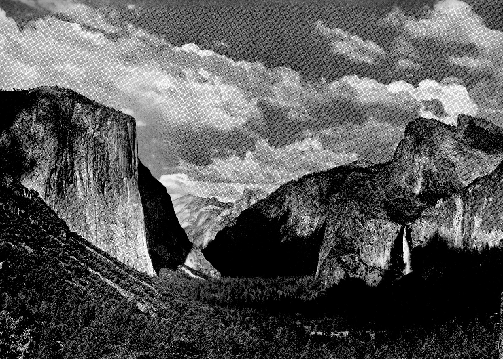
The first view of Yosemite Valley is a surprise. Whether you are driving from Big Oak Flats or El Portal, or descending on the Wawona Road, there comes a time when you round a corner and the valley suddenly appears before you. The view from the eastern end of the Wawona Tunnel, the longest highway tunnel in California, is especially remarkable (Figure 7.1). Ansel Adams took this photograph in 1938; it is one of the most famous of his career.
The view up the valley from the Wawona Tunnel is spectacular. On the left, six or seven kilometers away, is the prominent, near vertical west face of El Capitan. Beyond the face, El Capitan’s prominent buttress, aptly named the Nose, juts out and steepens slightly at the top, and so it appears to soar upwards to its brow as it rises more than 910 meters from the valley floor. Beyond El Capitan, the view continues eastward to the higher Sierra Nevada Mountains. In the distance, Half Dome, with a prominent black water streak on its north face, is silhouetted on the south side of the valley. Half Dome’s summit is 1,463 meters above the valley floor.
Opposite El Capitan, on the south side of the valley, Bridalveil Falls free falls 188 meters between the Leaning Tower and the Cathedral Spires. The valley contains many waterfalls, and most, like Bridalveil, are fed by streams draining hanging valleys that enter the main valley high above its floor. Bridalveil’s prominent location makes it the first waterfall seen by most valley visitors. Yet, the more famous Yosemite Falls, out of sight and a few kilometers farther up the valley, is the highest waterfall in North America and one of the highest in the world. Its upper portion drops more than 425 meters, and the entire drop, involving several falls, is 739 meters. Other tall Yosemite waterfalls include Ribbon Fall (491 meters) and Horsetail Fall (640 meters), both seasonal falls, which descend from the western and eastern ends of El Capitan, and another seasonal fall – Sentinel Fall (590 meters) – which is on the opposite side of the valley is a few kilometers farther east.
Yosemite Valley is cut into hard plutonic rocks of the Sierra Nevada Mountains. The valley floor lies at about 1,200 meters elevation, and cliffs rise a thousand of meters on either side. Yosemite is a small valley. The main part, the part considered by many to be most beautiful, is 11-16 kilometers long and about one to two kilometers wide. Near its upper end, it splits – the main valley trends east and Little Yosemite Valley extends several kilometers south before it too turns east and wraps around the southern side of Half Dome.
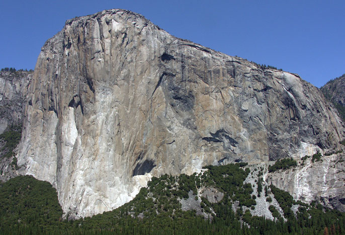
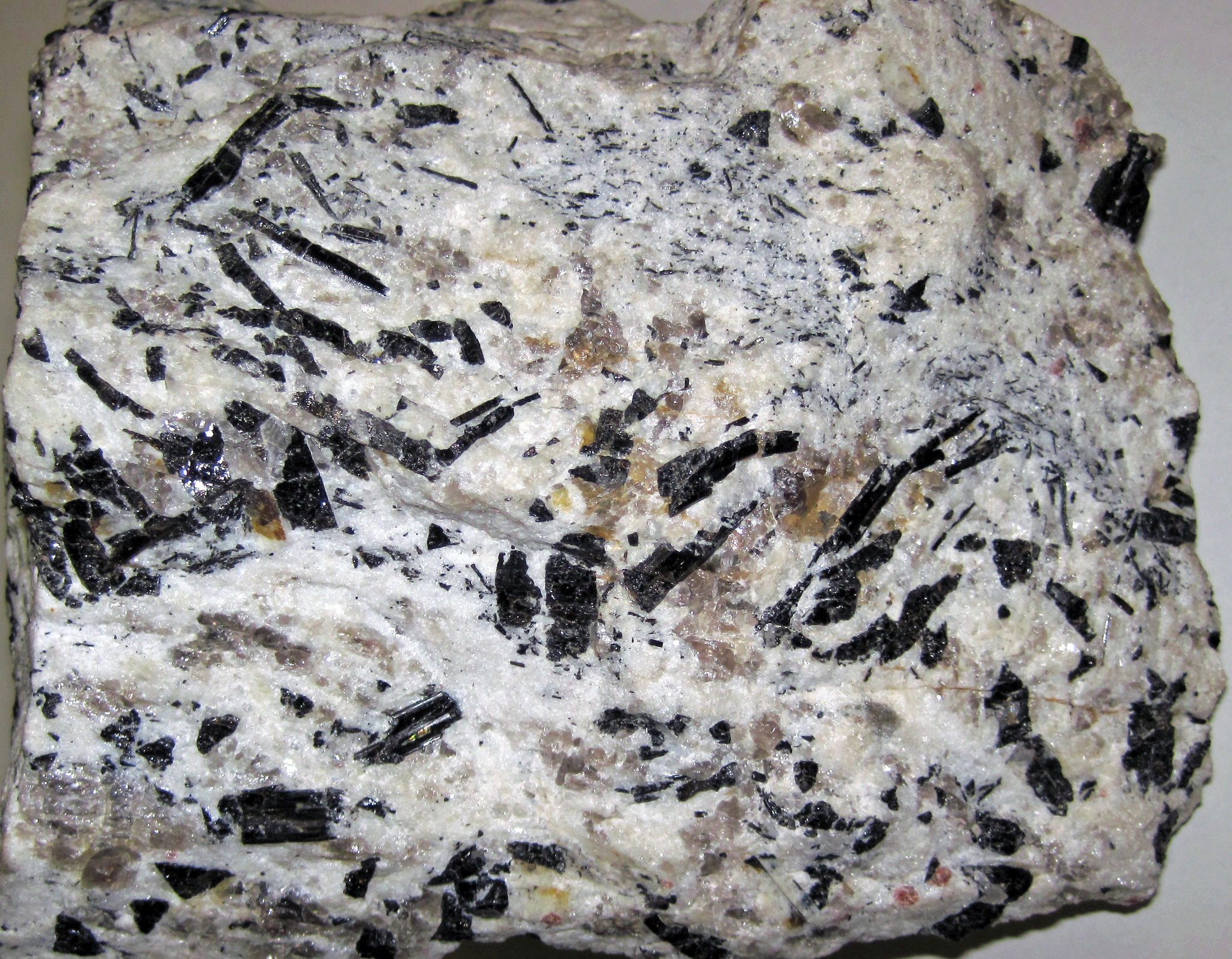
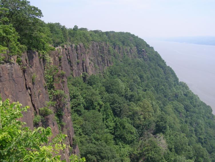
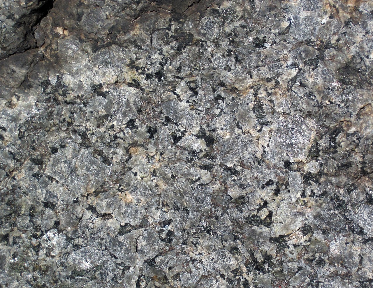
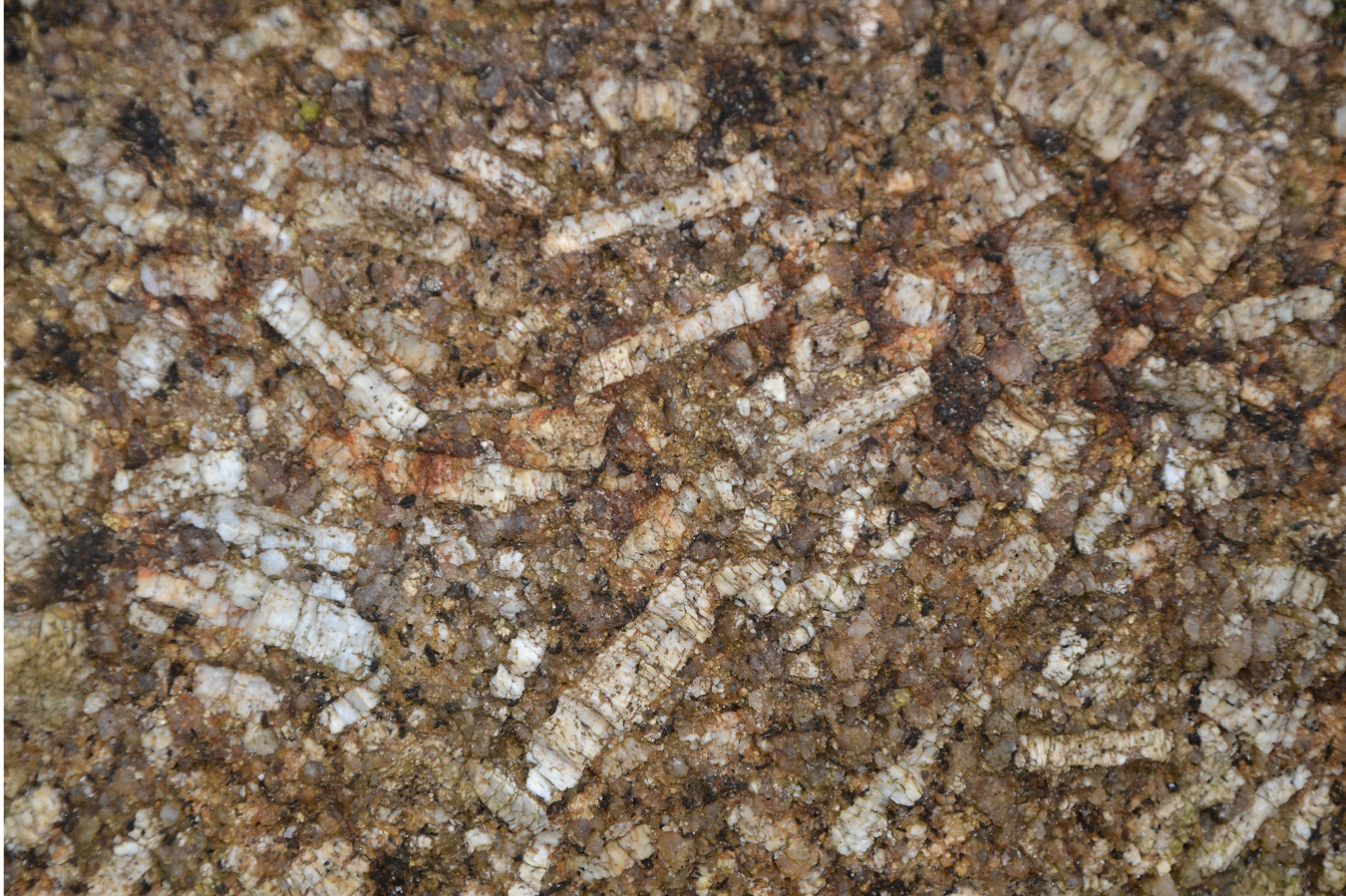
El Capitan is mostly composed of light gray granite or rocks closely related to granite. Collectively termed granitic, or sometimes granitoid, these light-colored rocks are composed chiefly of feldspars and quartz. But, if you focus in, you can see that there are different colors of rock exposed in El Capitan’s face, suggesting that there may be significant compositional variation. In places, a much darker rock, dark gray to black, is seen in blobs and splotches. This rock becomes especially prominent as you drive farther into the Valley, around the Nose. El Capitan’s southeast face, sometimes called the North American Wall, contains a large black body of rock shaped like our continent. It can be seen in Figure 7.2. On both the southwest and southeast faces, a myriad of white to light-gray dikes – small veins up to several meters thick – cut across the face in near horizontal directions.
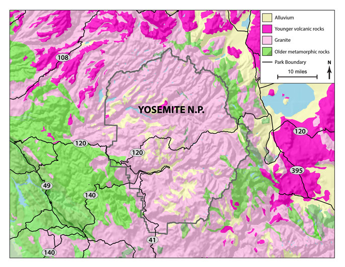
The plutonic rocks that make up the Yosemite region are part of the Sierra Nevada Batholith, a large mass of plutonic rocks made of multiple plutons of similar composition. The Sierra Nevada Batholith formed between 114 and 87 million years ago, when rising magmas intruded older country rocks. Remnants of the older host rocks can be found both east and west of Yosemite today. This geologic map of the Yosemite region (Figure 7.3) shows granitic rocks of the Sierra Nevada Batholith in light pink. Younger volcanic rocks and sediments are in yellow and hot pink to the north and east. Old metamorphic rocks – the rocks that the granitic magmas intruded – are in green, mostly west of the national park where the mountains give way to California’s Central Valley.
The intrusions that created Yosemite’s rocks marked the beginning of the formation of the Sierra Nevada Mountains. If associated volcanic rocks formed at that time, they have, for the most part, long since eroded away. However, much younger volcanic rocks (hot-pink color in the map) are in the region, most notably east of Yosemite near Bishop, California.
The Yosemite plutons crystallized several tens of kilometers beneath tall mountain ranges, but by about 70 million years ago, uplift and erosion had removed most of the overlying mountains. River valleys formed, and as erosion continued, the valleys deepened and cut downward. So, plutonic rocks were exposed, initially only in valleys and later over wider areas. The region was relatively static for a long time, but about 25 million years ago, renewed uplift and tilting began the process that led to present day Sierras. Streams cut even deeper, exposing more plutonic rocks.
Plutons solidifying at depth are under great lithostatic (same in all directions) pressure. During uplifting, the rocks are subjected to various kinds of directional stress as, simultaneously, pressure decreases and rocks expand. Consequently, once solid rocks may develop shear zones (zones of intense strain, associated with faulting or elastic deformation) and joints (fractures that lack any movement parallel to the plane of the fracture). The shear zones and joints may become focuses for weathering and erosion, often leading to rock falls. These processes began the formation of the steep outcrops we see in Yosemite today.

One result of decreased pressure is exfoliation. As uplifted rocks expand, joints develop parallel to rock surfaces. Layers can break off in the same way that layers may peel from an onion. Slabs and sheets up to meters thick can separate from the main rock body and either stay in place or fall away. The photo in Figure 7.4 is a picture of the summit of Yosemite’s Half Dome. The exfoliating slabs of rock are clear to see. For scale, look closely and you will see a parade of people going up a cabled walkway just to the right of the large pine tree. While granites and related plutonic rocks seem to provide the best examples of exfoliation, plutonic rocks of other sorts may exhibit the same features, too.
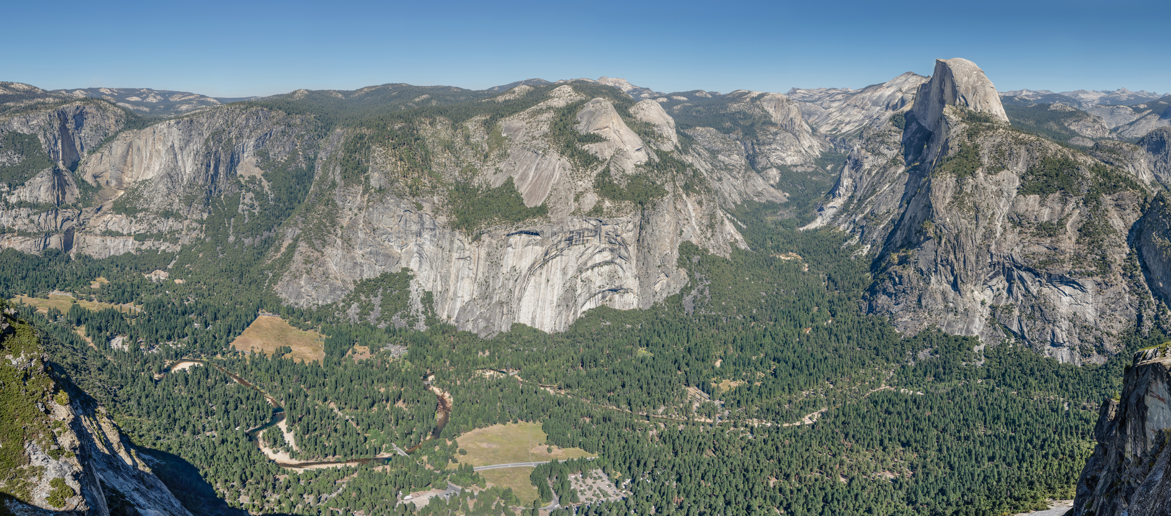
The view in Figure 7.5 shows Yosemite Valley with peaks of the High Sierra in the background. Exfoliation created the prominent Royal Arches in the center of the photo. And, over time, exfoliation has led to rounding of many rocky peaks – including Half Dome, the highest peak on the right – in the region. The ultimate sculptor of Yosemite National Park, however, was ice. The region has seen extensive glaciation during the past 30 million years. The Sherwin Glaciation, which occurred about 1 million years ago, added the final polishes. At that time, mountain icefields formed at higher elevations and flowing glaciers naturally occupied the river valleys already present. Moving ice rounded and polished mountain tops, deepened valleys, rounded and smoothed valley walls, and plucked pieces of rock that were later dropped far from their sources. Consequently, valleys became wider and obtained their present day flat bottoms and U-shapes as shown in Figure 7.5. During this process tributary valleys were cut off to produce hanging valleys far above the main valley floors, such as the one responsible for Bridalveil Falls, shown in Figure 7.1.
7.2 Two Large Plutonic Rock Bodies
7.2.1 The Sierra Nevada Batholith
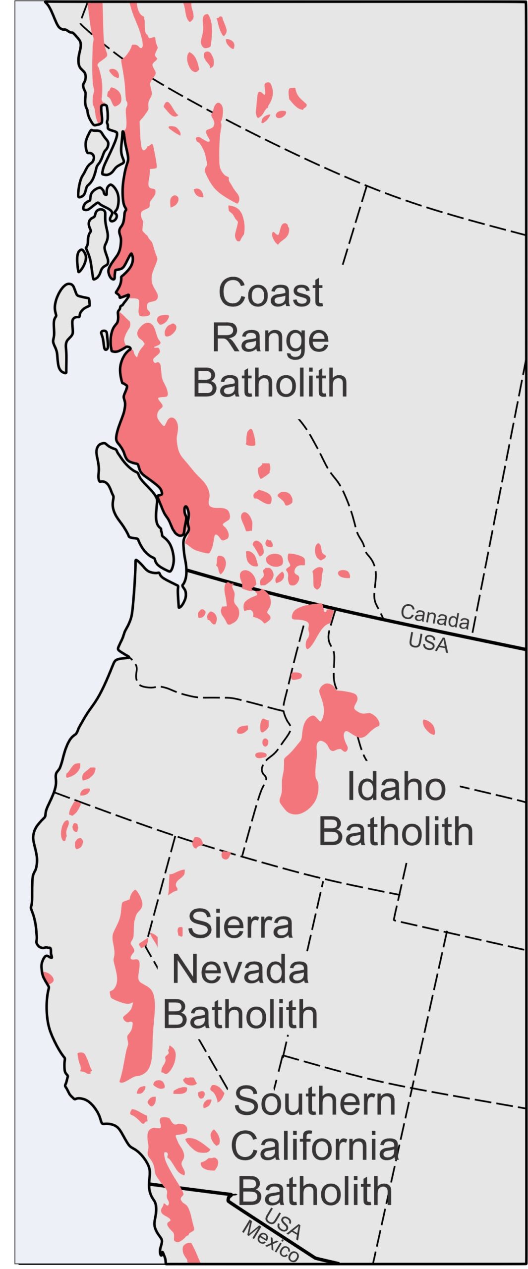
Silicic and intermediate magmas naturally rise toward Earth’s surface, but many stall. They cool slowly 5-30 kilometers beneath the surface, producing plutonic rocks, often creating batholiths made of many individual plutons of similar but not identical age and composition. Although by definition, a batholith must be larger than 100 square kilometers, this definition is misleading because most are much larger than the minimum. In western North America, the Coast Range Plutonic Complex of western Canada and Alaska is 182,500 square kilometers, the Idaho Batholith is 45,000 square kilometers, and the Sierra Nevada Batholith is 40,000 square kilometers. These batholiths, shown in Figure 7.6, along with the Southern California Batholith and the Peninsular Ranges Batholith in Baja California (not shown in Figure 7.6), form belts that roughly parallel the West Coast. Similar batholiths are found in the South America’s Andes. Nova Scotia’s South Mountain Batholith, at 7,300 square kilometers, is the largest in the Appalachian Mountains.
Batholiths have complex histories and irregular shapes, and their plutons often cut through or around earlier intrusions. Many, as can be seen in Figure 7.6, are associated with smaller plutonic rock bodies that do not connect to the main batholith but have similar compositions and ages. Most, like the Sierra Nevada Batholith, form deep in Earth near the base of the crust. Geochemical studies suggest that batholiths develop from multiple magma pulses (intrusions in the same place at different times) and contain multiple plutons. Contacts between different plutons, however, may be difficult to see in an outcrop because most of the rocks may look quite similar. Yet, although often appearing the same, individual plutons are sometimes distinguished by their chemistry, mineralogy, age, texture, or crosscutting relationships.
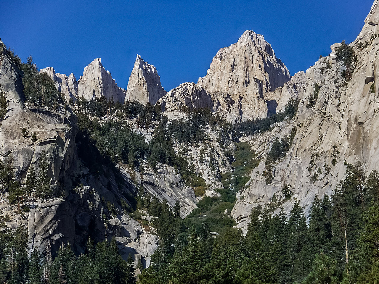
Although the rocks exposed in El Capitan are older, most of the plutonic rocks exposed in Yosemite National Park formed during the Cretaceous Period, about 114 to 87 million years ago. They are all part of the Sierra Nevada Batholith. Figure 2.27 shows Mt. Whitney, California, the highest point in the batholith and in the lower 48 states. The entire batholith, composed of hundreds of plutons ranging from small to huge size, took more than 100 million years to form.
7.2.2 The Idaho Batholith
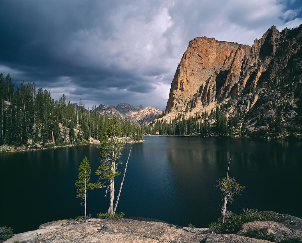
7.7 A view of the Elephant’s Perch, a prominent peak in Idaho’s Sawtooth Mountains
Figure 7.7 is a photo of the prominent Elephant’s Perch, 15 kilometers south-southwest of Stanley, Idaho. The “Perch” is part of the Idaho Batholith.
The Idaho Batholith is larger than the Sierra Nevada Batholith and covers an interrupted 25,000 square kilometers of central Idaho and western-most Montana. The batholith formed from a series of intrusions that developed in the late Cretaceous beginning about 98 million years ago. The last intrusions occurred about 53 million years ago in the earliest Eocene. Rocks of the batholith make up the high peaks of Idaho’s Bitterroot Mountains, Salmon River Mountains, and Sawtooth Range. The Elephant’s Perch, seen above, is in the Sawtooth Range.
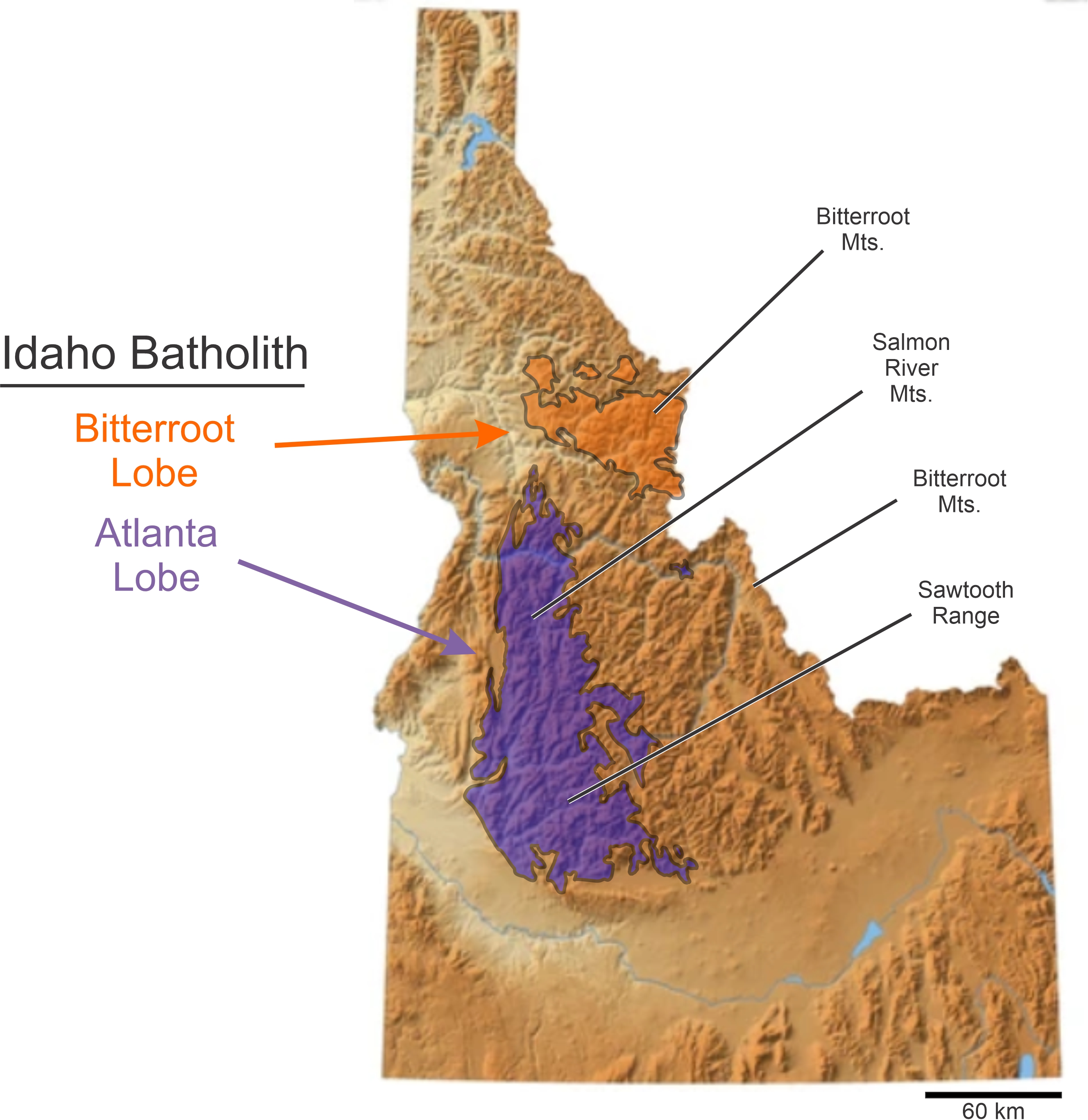
Figure 7.8 shows the location of the batholith. It is mostly in Idaho but extends a short distance into Montana (not shown). Like all large batholiths, rocks of the Idaho Batholith are silicic. The most common lithologies are muscovite-biotite granites and biotite-containing granodiorites. Lesser amounts of quartz monzonite, quartz diorite and diorite are also present. The Elephant Perch, seen in Figure 7.7, is made of pinkish granite and quartz monzonite.
The Idaho Batholith contains two parts: the smaller Bitterroot Lobe in the north (shown in orange), and the larger Atlanta Lobe in the south (in purple). The lobes are separated by a 20 kilometer wide region of Precambrian metasedimentary rocks (brown hues). The rocks of the Bitterroot Lobe are, on average, 40-45 million years younger than the rocks of the Atlanta. An even younger series of intrusions, the Challis Suite (omitted from this map), intrudes both lobes and country rocks of the surrounding region. The Challis suite is sometimes considered part of the batholith but is petrologically distinct because it contains a diverse suite of rocks that range from granite to gabbro.
● Box 7.1 The California Gold Rush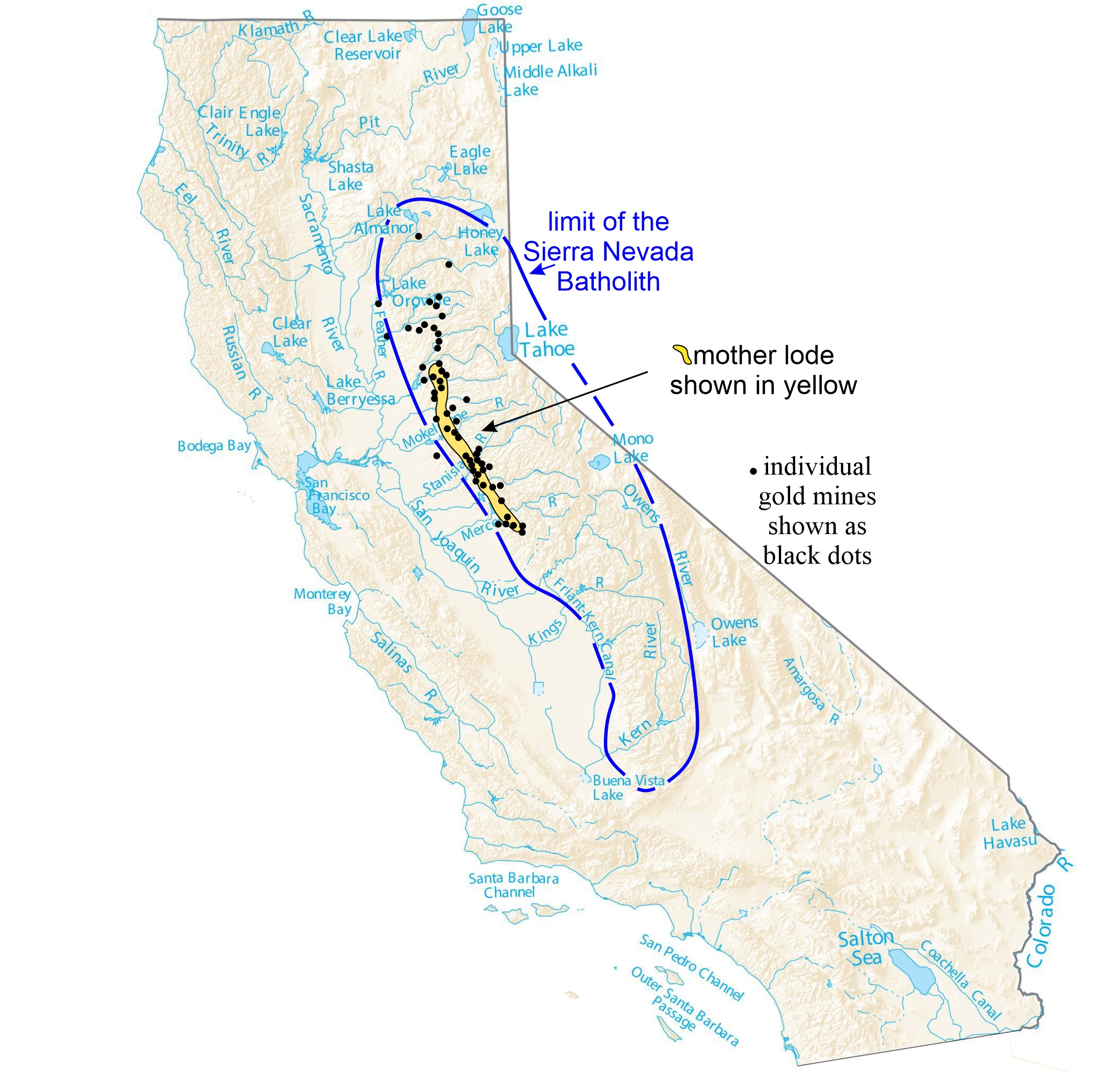 The batholith rocks of California were the source of the gold that sparked the short-lived California gold rush beginning in 1848. Figure 7.9 shows where the mining occurred. Gold, originally in granitoids, had dissolved and concentrated in veins called lodes. Subsequent weathering and erosion of the lodes produced detrital gold that concentrated in stream bottoms. The gold rush started with placer mining – mining of gold from stream deposits in Sierra Nevada foothill valleys. Mining soon exhausted the placers, but miners successfully followed the gold upstream and discovered the Mother Lode higher in the mountains. Some lodes are single ore-containing veins. The California Mother Lode, however, is not one vein, but a zone of veins in plutonic rock. The zone, which stretches from the mountains northwest of Sacramento to the foothills southwest of Yosemite National Park, is up to 6 kilometers wide and nearly 200 kilometers long. Although placer mining ceased after a few years following the initial gold rush, the Mother Lode produced significant amounts of gold for about 100 years. |
7.3 The American Cordillera
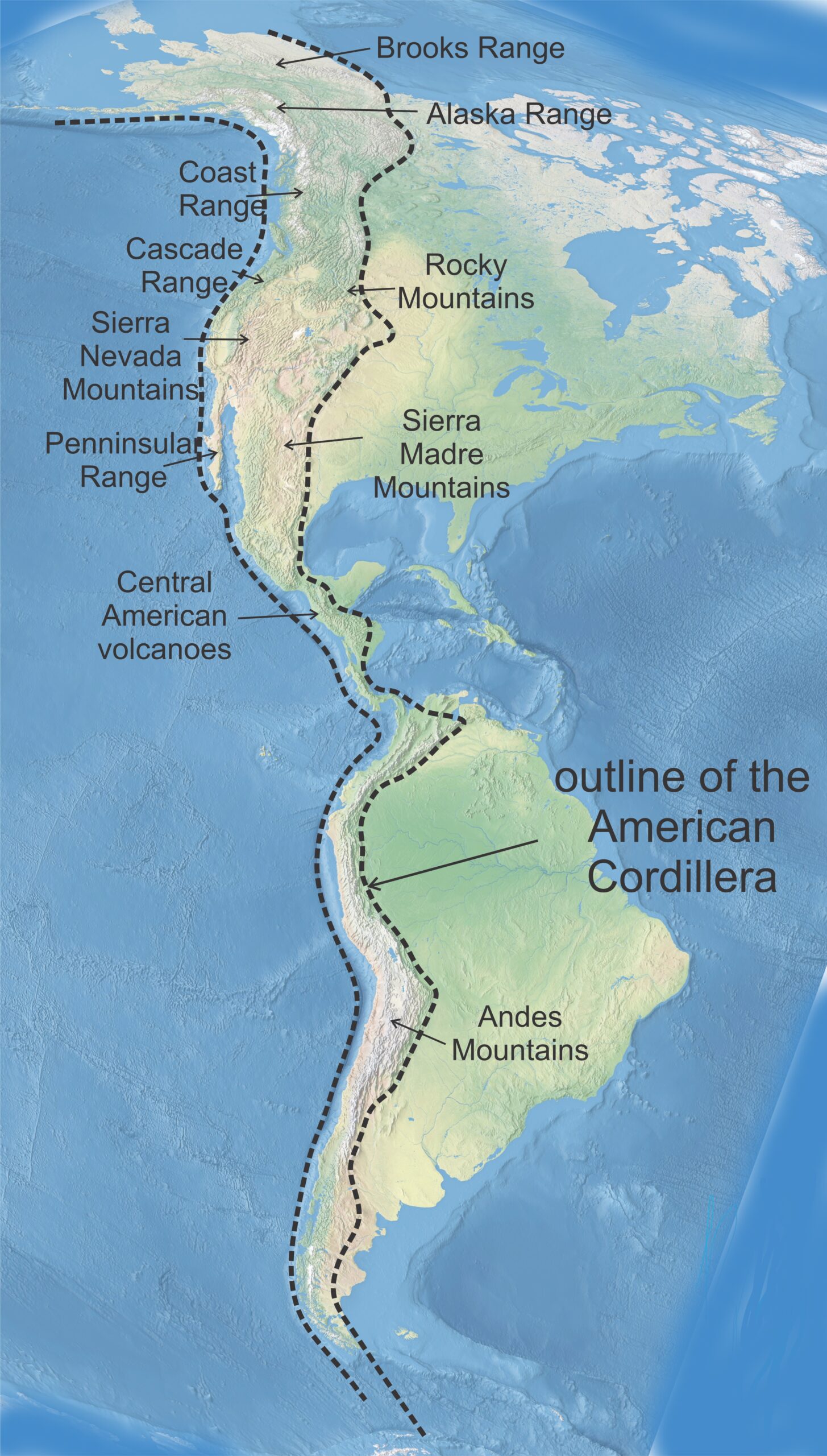
The batholiths of western North America are all part of the American Cordillera, a chain of mountain ranges, intermontane basins between the ranges, and plateaus extending from northern Alaska through North America, Central America, and South America and ending in Antarctica. The Cordillera, outlined in Figure 7.10, includes the Cascade Mountains of Washington and Oregon and other volcanic mountain chains. It includes coast ranges such as those along the western margin of North America and the Andes, and interior ranges including the Sierra Nevada and Rocky Mountains. The entire cordillera owes its origin to interaction of tectonic plates and subduction along the eastern margin of the Pacific Ring of Fire. Subducting slabs generated magmas that led to volcanic and plutonic rocks, and converging plates caused deformation and uplift, ultimately leading to exhumation of once deep-seated rocks.
Active volcanism still occurs in the Cordillera today: in Alaska, in the Cascade Mountains, in parts of Central America, and in many parts of the Andes Mountains. In other places, like the High Sierras, 10s to 100s of million of years of uplift and erosion has exposed plutonic rocks that were once deeply buried. In Yosemite, there are a few small occurrences of old volcanic rocks – older than the plutonic rocks – that once probably mantled the entire region.
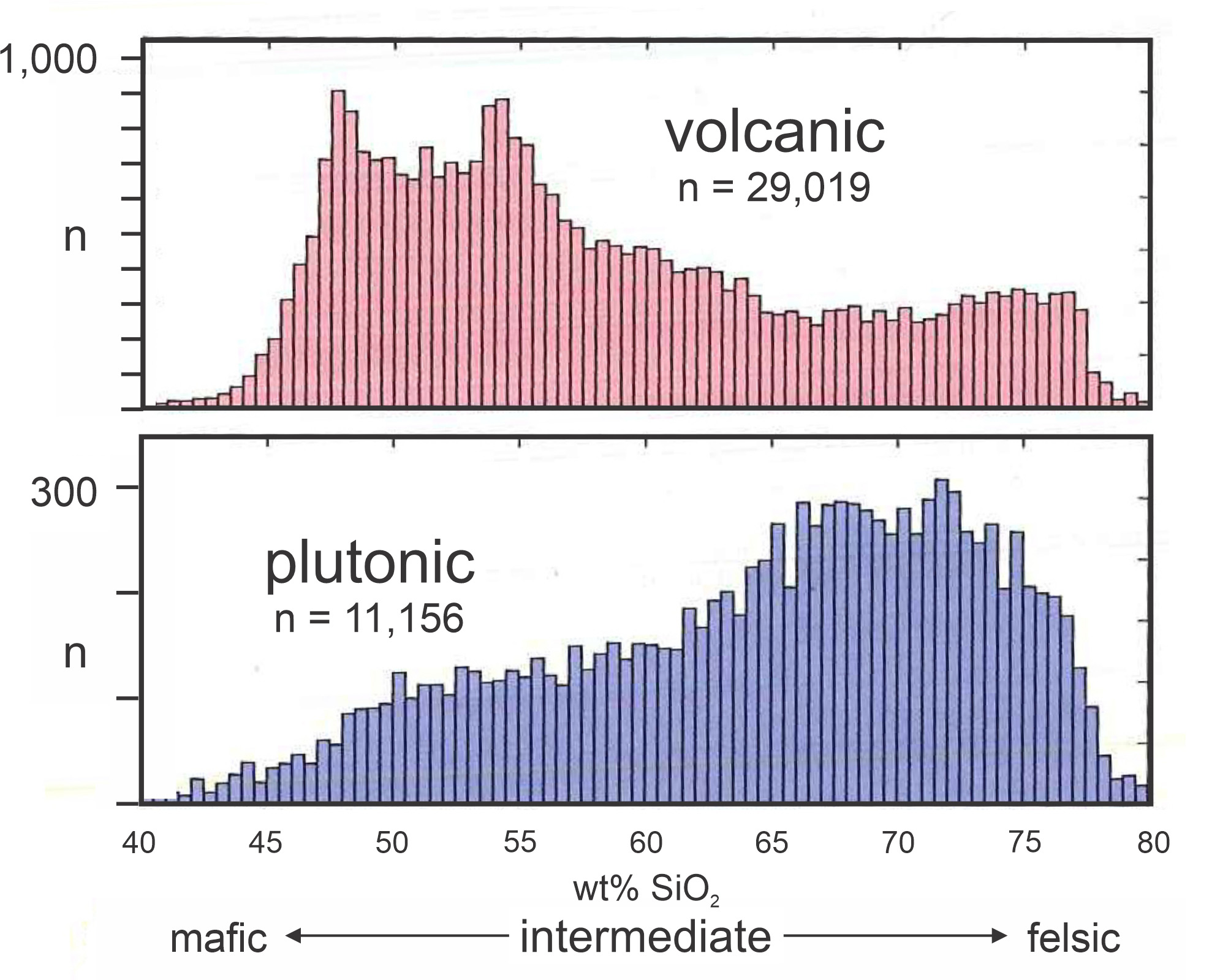
Although volcanic rocks dominate some regions, and plutonic rocks dominate other regions, both volcanic and plutonic rocks are found along the entire length of the Cordillera. As Figure 7.11 shows, both groups range from mafic to silicic. The vertical axis in Figure 7.11 (n) shows the number of occurrences and, although many more volcanic rocks have been analyzed than plutonic rocks, the similarity in composition range (40-80 wt% SiO2) is clear. Plutonic gabbro, diorite, tonalite, granodiorite, and granite match volcanic basalt, andesite, dacite, and rhyolite. Overall, though, the plutonic rocks are more silicic than the volcanic rocks are.
The close proximity of volcanic and plutonic rocks, and their similar compositions, support the historical view that the plutonic rocks are remnants of magma chambers that once fed active volcanoes above and that plutonic and volcanic rocks come from the same sources and processes. Some recent investigators, however, have suggested that the relationships may not be quite so simple, and research continues today to illuminate what Lundstrom and Glazner (2016) call an “enigmatic relationship” between silicic volcanic and plutonic rocks.
7.4 Plutons of Different Kinds
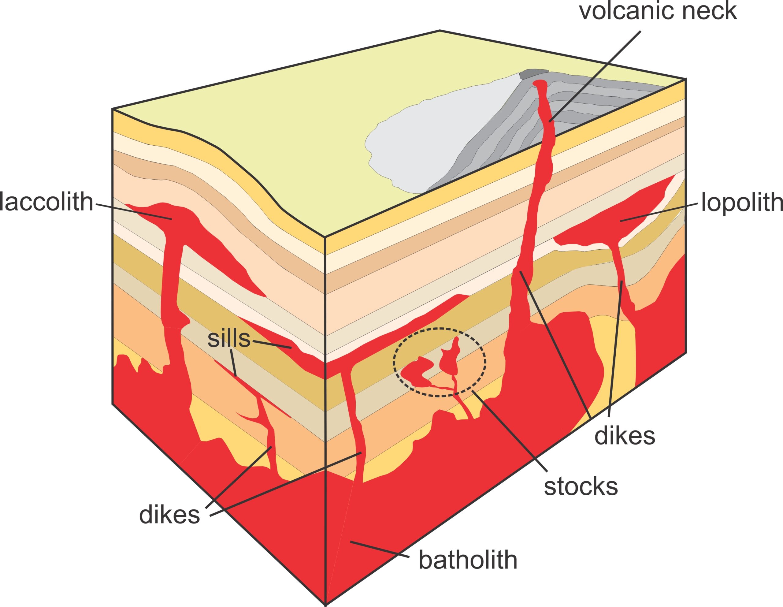
Petrologist have used many names to describe intrusive rock bodies – but fortunately, most see little use today. Pluton is a general term for any such body, and plutons come in many shapes and sizes (Figure 7.12). In practice, however, geologists use the word pluton mostly only to refer to blobby or irregular rock masses, and use more specific terms for rock bodies with more distinctive shapes (Figure 7.12). Table 7.1 defines some of the more specific names.
| Table 7.1 Different kinds of plutonic rock bodies | |
| intrusive rock body | description |
| pluton | any body of intrusive igneous rock |
| stock | a small irregularly shaped pluton with a surface exposure of less than 100 square kilometers |
| batholith | a large pluton or plutonic complex with a surface exposure of greater than 100 square kilometers |
| dike | a sheet-like intrusion that cuts through or across layers of preexisting rock |
| sill | a sheet-like intrusion that is conformable with layers of preexisting rock |
| lopolith | a large igneous intrusion with a relatively flat upper surface and an overall bowl-like shape |
| laccolith | a large igneous intrusion with a relatively flat lower surface and an overall shape of an upside-down bowl |
7.4.1 Batholiths, Lopoliths, and Laccoliths
Large plutonic bodies include batholiths, plutons, lopoliths, and laccoliths. We call all of them batholiths (from the Greek bathos meaning depth and lithos meaning rock) if they are larger than 100 square kilometers. Batholiths are generally compound (made of many individuals plutons like the Sierra Nevada Batholith and the Idaho Batholith). All of the world’s batholiths have an overall silicic (granitic) or, less commonly, intermediate composition.
Lopoliths may be quite similar to other intrusions or batholiths but have dish shapes or funnel shapes. They develop their shapes when magma intrudes into space between layers of preexisting country rock. Lopoliths may be huge and are typically layered. They generally form, like other batholiths, from multiple magmatic intrusions. Most lopoliths have an overall mafic or ultramafic composition. We will discuss lopoliths in more detail later in this chapter (Section 7.6.3) when we discuss layered mafic intrusions.
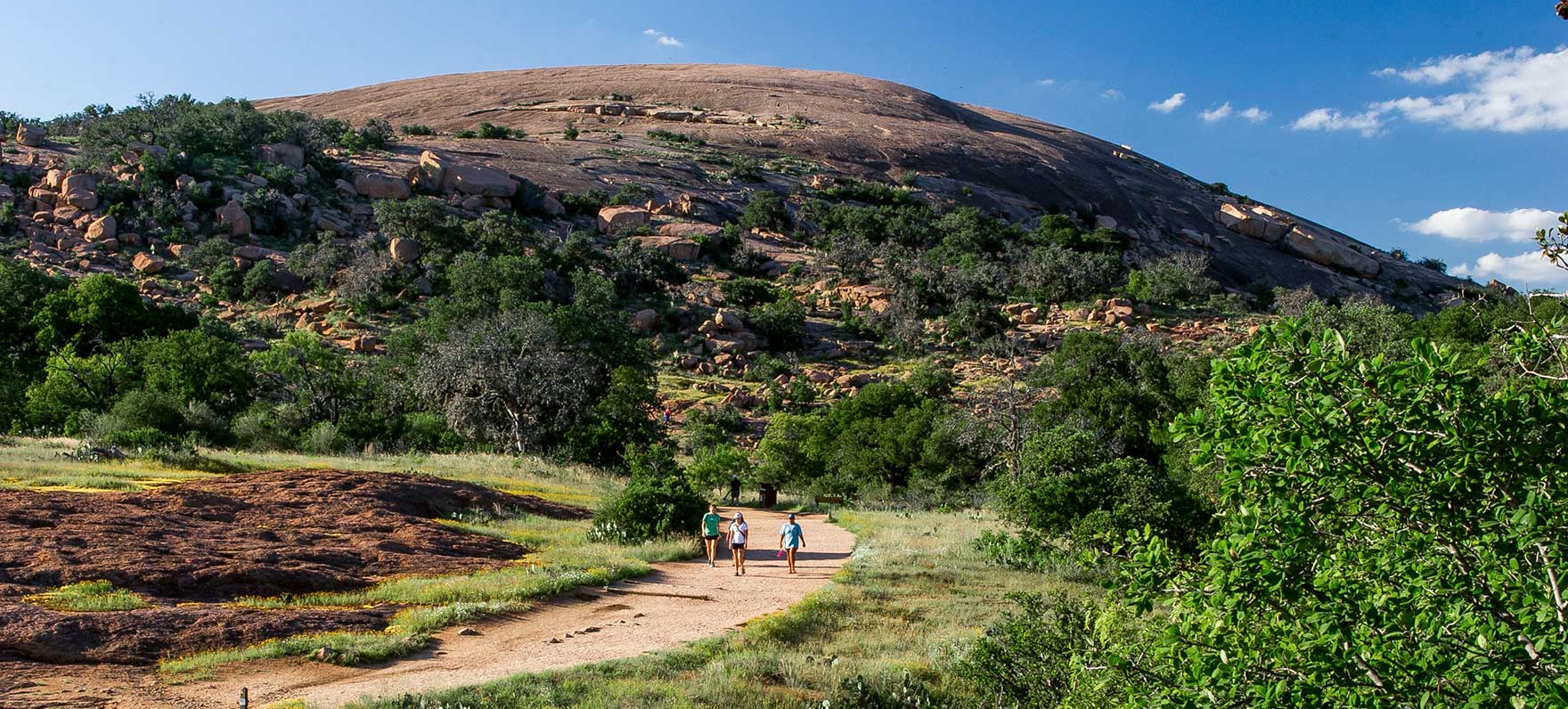
Laccoliths are quite similar to lopoliths and conform with country rock layering. The key differences between laccoliths and lopoliths is that laccoliths bulge upwards and have shapes akin to an inverted bowl or mound, and lopoliths do the opposite. Additionally, lopoliths are often complex layered intrusions of large size. Laccoliths, in contrast, may be relatively small. Figure 7.13 is a view of Enchanted Rock, a small laccolith in the Hill Country of central Texas, west of Austin.
Box 7.2 The Needles Highway, South Dakota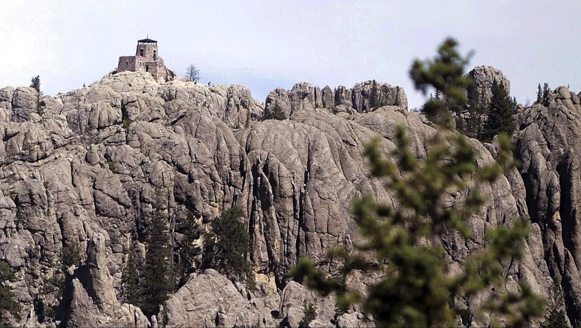 South Dakota’s Black Hills were formed by an uplift that occurred near the end of the Cretaceous Period about 65-70 million years ago. The uplift created a dome structure 10s of kilometers across. Younger sedimentary rocks lap up on the edge of the uplift. In the center of the dome, once deep-seated plutonic rock – the Harney Peak Granite – is exposed at the surface. The granite is two billion years old, and in many places coarse-grained and pegmatitic. The Black Hills contains thousands of granite outcrops, but the most spectacular exposures are at Mt. Rushmore (where Gutzon Borglum carved the Presidents’ faces into the rock during a long project between 1927 and 1941), on Black Elk Peak (seen in Figure 7.14), and along the Needles Highway near Custer, South Dakota. The top of Black Elk Peak is the highest elevation point between North America’s Rocky Mountains and Europe’s Pyrenees. 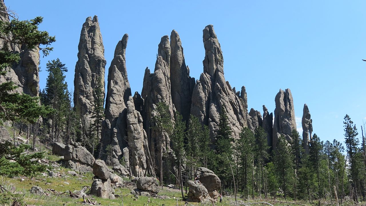 The Needles Highway, in the Black Hills near Black Elk Peak, provides a speculator drive. Along this highway granite spires, originally stocks (small plutons) that intruded into country rock, stick up like fingers into the sky. These stocks were uncovered by many millions of years of erosion when surrounding rocks eroded away. Figure 7.15 is a view from the Needles Highway 20 kilometers northeast of Custer, South Dakota. Enlarge the photo and you will see people for scale. |
7.4.2 Sheet-like Plutonic Rock Bodies: Sills and Dikes
Sheet-like intrusions include sills and dikes. The difference is that sills are conformable intrusions, which means they occupy space between layers that they push apart as they intrude. Thus, they develop parallel to sedimentary layering (and sometimes to metamorphic or igneous layering). In contrast, dikes are non-conformable intrusions, which means they cut through or across preexisting layers of rock. Dikes and sills range from very small to large, with thicknesses from less than a centimeter to many hundreds of meters. They may extend laterally for long distances. Some of the largest dikes and sills are differentiated because early-formed crystals were separated from the remaining magma.
|
|
|
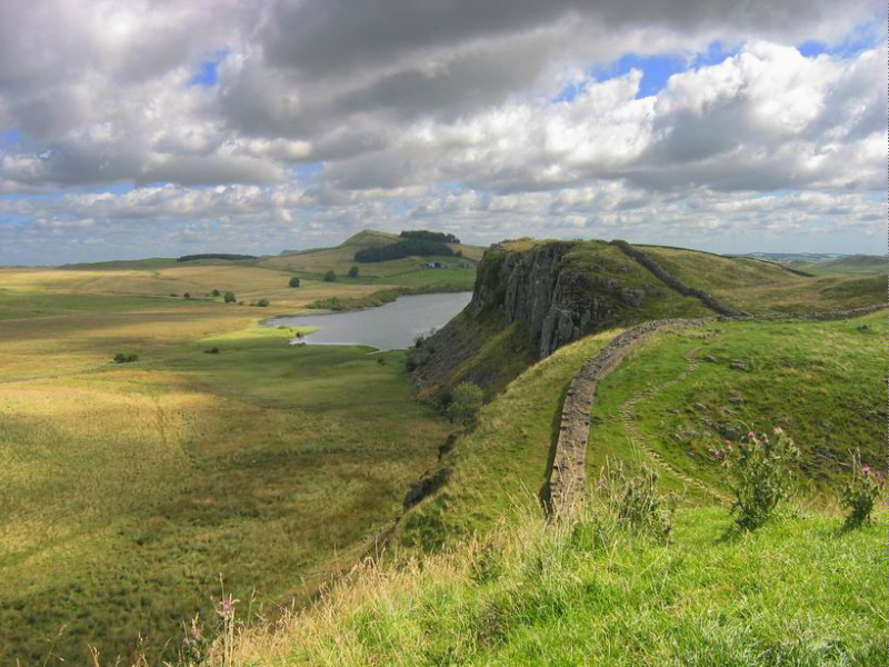
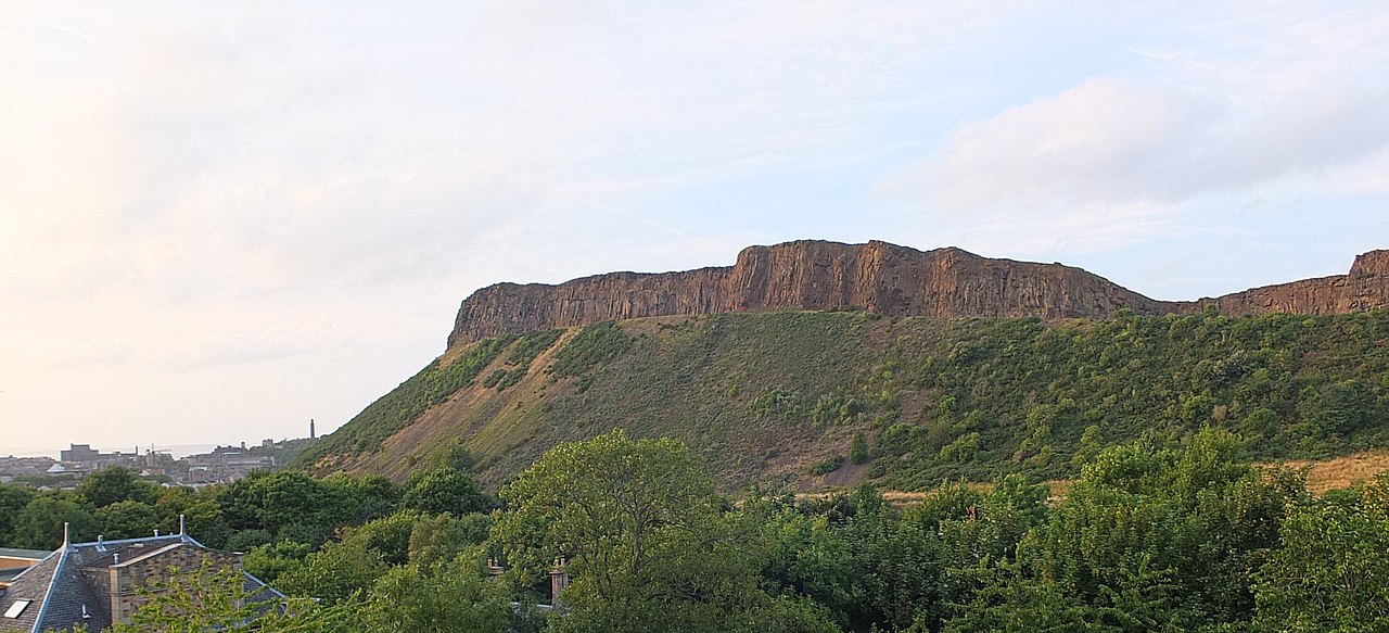
Most sills are created by magma delivered through dikes, but the sills themselves have geometries sometimes described as tabular. They are generally emplaced in horizontal layers but may subsequently be tilted during tectonism. Although emplaced at depth, uplift and erosion can expose sills at the surface. Figure 7.16 shows an outcrop of the Whin Sill forming a ridge in northern England. The stone wall on top of the sill is a restored portion of Hadrian’s Wall, a Roman fortification built around AD 122 that marked the edge of what the Romans considered the civilized world. And Figure 7.17 is a view of the Salisbury Crags, a major sill that towers over Edinburgh, Scotland.

Dikes, non-conformable sheet-like intrusions, cut across sedimentary or other layering, or through massive rock that has no layering. Dikes generally form from magma intruding along steep or near-vertical fractures, but tectonic forces may later rotate them to different orientations. The term vein is sometimes used as a synonym for dike, but most geologists reserve the word vein for small, irregular and branching, or discontinuous, intrusions. So, in contrast with veins, dikes are larger, sometime huge, and have uniform thickness and parallel sides. The photo in Figure 7.18 shows a typical example of light-colored veins cutting through igneous rock near Imperia, Italy.
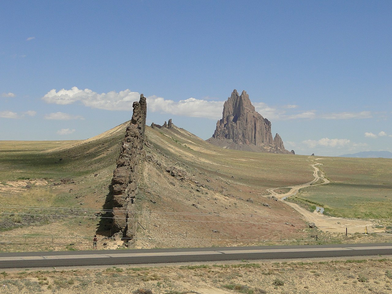
Although most dikes stall and crystallize before reaching Earth’s surface, a special kind of dike, called a feeder dike, carries magma to the surface to produce volcanic eruptions. In outcrop, distinguishing feeder dikes from other kinds of dikes is often difficult if erosion has removed all overlying volcanic rocks. However, remnants of feeder dikes are sometimes preserved as fins or volcanic necks, frozen magmas that once fed a volcano but now have become exposed by the removal of surrounding country rocks. The fin-like dike seen in Figure 7.19 is a feeder dike that delivered magma to Shiprock, a volcanic neck that is in the distance. Shiprock’s pointed peak is the erosional remnant of a volcanic neck, made mostly of volcanic breccia and a rare highly potassium-rich mafic rock called minette. Half a dozen major minette dikes radiate outward 1-10 kilometers from Shiprock; the most prominent is in this photo. Because the dikes are erosion resistant, they now stand as thin fins above the surrounding desert floor. anchor
7.4.3 Aplite and Pegmatite
As discussed in Chapter 3, magmas do not crystallize all at once, and their compositions change as crystallization proceeds. The last remaining liquid portion may crystallize separately from already-formed crystals, either as segregations within a larger pluton or as intrusions into surrounding rocks. These late stage magmas contain leftovers and so are typically enriched in dissolved volatiles (commonly water and sometimes chlorine, fluorine, or carbon dioxide). They also become enriched in incompatible elements that did not enter earlier formed minerals. Consequently, late stage magmas often contain high concentrations of boron, beryllium, lithium, uranium, thorium, cesium, and other generally minor elements. Because the first minerals to crystallize from any magma are relatively mafic, late-stage magmas are more silicic than their parents – they are richer in silicon, aluminum, and potassium.
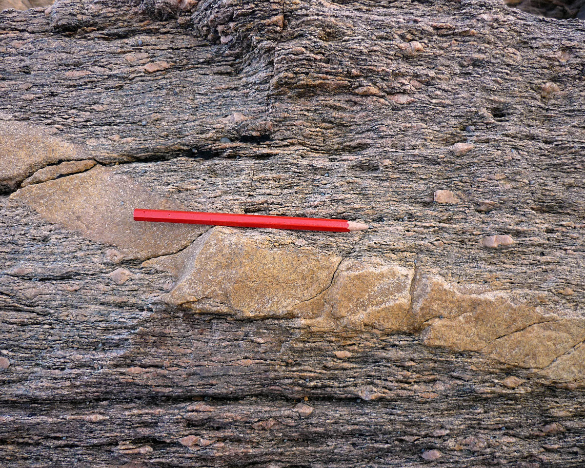
If late-stage magmas lose their volatiles, they may cool quickly and form aplites, very fine-grained rocks that contain crystals we cannot see without a hand lens. Aplites are typically narrow, from a centimeter to perhaps a meter in width, white, gray, or pink dikes and veins, sometimes described as having a sugary rock texture. They may intrude rocks of just about any sort, typically silicic or intermediate plutons or, less commonly, mafic plutons. Often, aplites occur in swarms of roughly parallel veins traversing a much larger host rock. The aplite shown here (Figure 7.20), with a pencil for scale, has intruded a metamorphic rock near Sables d’ Olonne in western France.
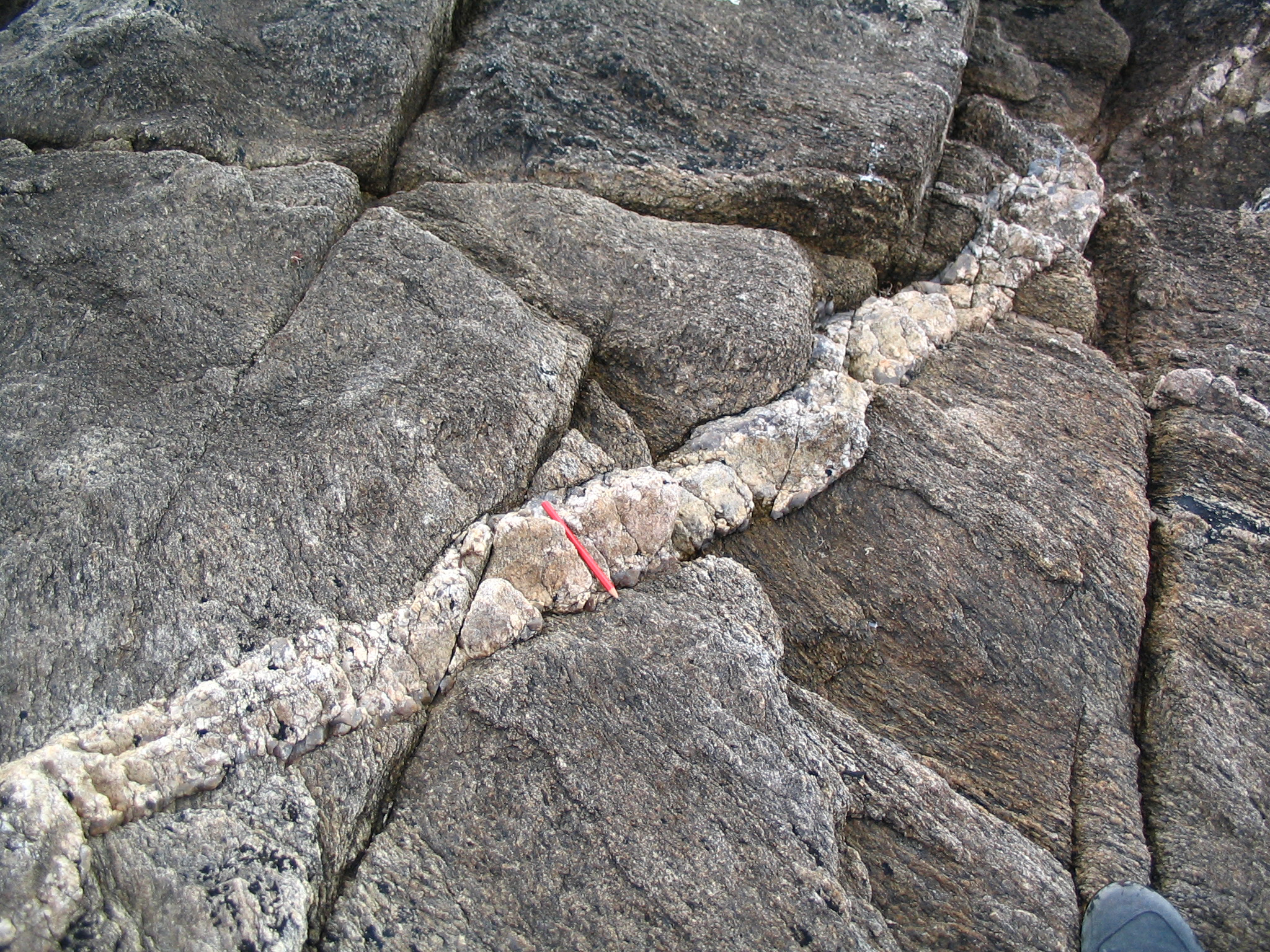
Instead of forming aplites, many late-stage magmas crystallize to form pegmatites. The word pegmatite comes from a Greek word for bind together, because typical pegmatite textures show intricate crystal intergrowths. The dike shown in Figure 7.21 is a pegmatite vein that intruded gneiss near Sables d’ Olonne in western France. Note the pencil for scale.
Pegmatites are generally small compared with other plutonic bodies, typically no more than a few hundred meters in their longest dimension and often much smaller. They may be dikes or sills. They also commonly form as small irregular plutons that contain coarse mineral crystals, often with exotic compositions. Typical pegmatites, like the one seen in Figure 7.21, cut across other igneous rocks or metamorphic rocks. Less commonly, they intrude sedimentary rocks. Although pegmatite bodies come in many different shapes and sizes, we use the adjective pegmatitic to describe any intrusive rock body that contains uncommonly coarse grains.

Large pegmatites are often mineralogically zoned, with inner zones having distinct mineralogies compared with outer zones. Pegmatites vary greatly in geometry and mineralogy, but Figure 7.22 shows a generalized configuration with different minerals in concentric zones. The border zone, commonly only a few centimeters thick, is the fine-grained chilled margin that developed at the time of pegmatite intrusion. Crystal size increases from the border zone inward to the core. The wall zone may be up to several meters thick and contain large crystals up to 30 cm or so in long dimension. In typical pegmatites, dominant minerals in this zone include feldspars, quartz and muscovite, sometimes with tourmaline and beryl. Intermediate zones contain larger crystals of feldspars, quartz and micas than the wall zone. But other minerals including beryl, spodumene, or tourmaline, may be present. Normally rare minerals such as columbite-tantalite, pollucite, and lithium phosphates may occur in this zone too. The core zone in many pegmatites is nearly entirely quartz.
No matter the rock composition, crystal size sets pegmatites apart from other intrusive rock bodies. The minimum crystal dimension in pegmatites is, by definition, 1 centimeter, and some pegmatites contain crystals are up to 10-15 meters in their longest dimension. Figure 7.23 is a photo of the tourmaline-bearing Crabtree Pegmatite in Mitchell County, North Carolina. Black tourmaline crystals up to several centimeters long are prominent. The white mineral that makes up about half the specimen is feldspar and the gray glassy material is quartz. Minor rose-colored garnet is also present – the most easily seen garnet crystal is near the bottom of the sample on the right side.
Pegmatites contain most of the largest mineral crystals in the world. In many rocks, large crystals are the result of very slow crystal growth, but the large crystals in pegmatites owe their size mostly to the presence of water and other volatiles in magmas. These volatiles kept the magmas fluid, allowing ions to migrate easily to growing crystals. This produced fewer, but larger, crystals than are found in most plutonic rocks. Although normal pegmatites form from magmas, similarly textured coarse rocks may also form by metamorphic or metasomatic (alteration) processes.
Most pegmatites have an overall granitic composition. Although pegmatites of other compositions exist, petrologists generally think of very coarse-grained quartz- and K-feldspar-rich rocks when they hear the word pegmatite. Granitic pegmatites are typically associated with granitic plutons but may be separated by short distances. These pegmatites contain all the minerals typically associated with granite, including essential quartz and K-feldspar, and often accessory plagioclase, micas, or amphibole. Intermediate and mafic pegmatites are usually in the margins of larger intermediate and mafic intrusive bodies.
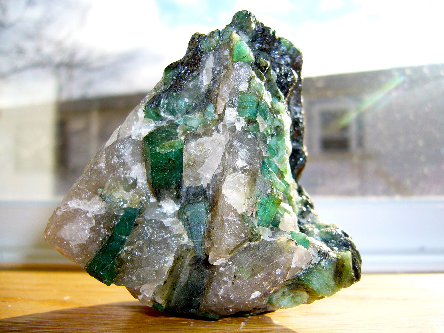
Because they crystallize from late-stage magmas containing incompatible elements, many pegmatites contain minerals that are otherwise uncommon. Boron, typically a very minor element in magmas, can concentrate in pegmatites to produce tourmaline – the most common boron mineral – for example the tourmaline in Figure 7.23. And beryllium, also typically a minor element, may concentrate to produce beryl – the most common beryllium mineral – like the beryl (emerald) seen in Figure 7.24. High concentrations of lithium may yield lithium minerals such as lepidolite, spodumene, or petalite. Cesium-, tantalum-, and niobium-minerals such as columbite, tantalite, or niobite may also be in granitic pegmatites. Less exotic, but often large and spectacular apatite and fluorite crystals are also commonly present.
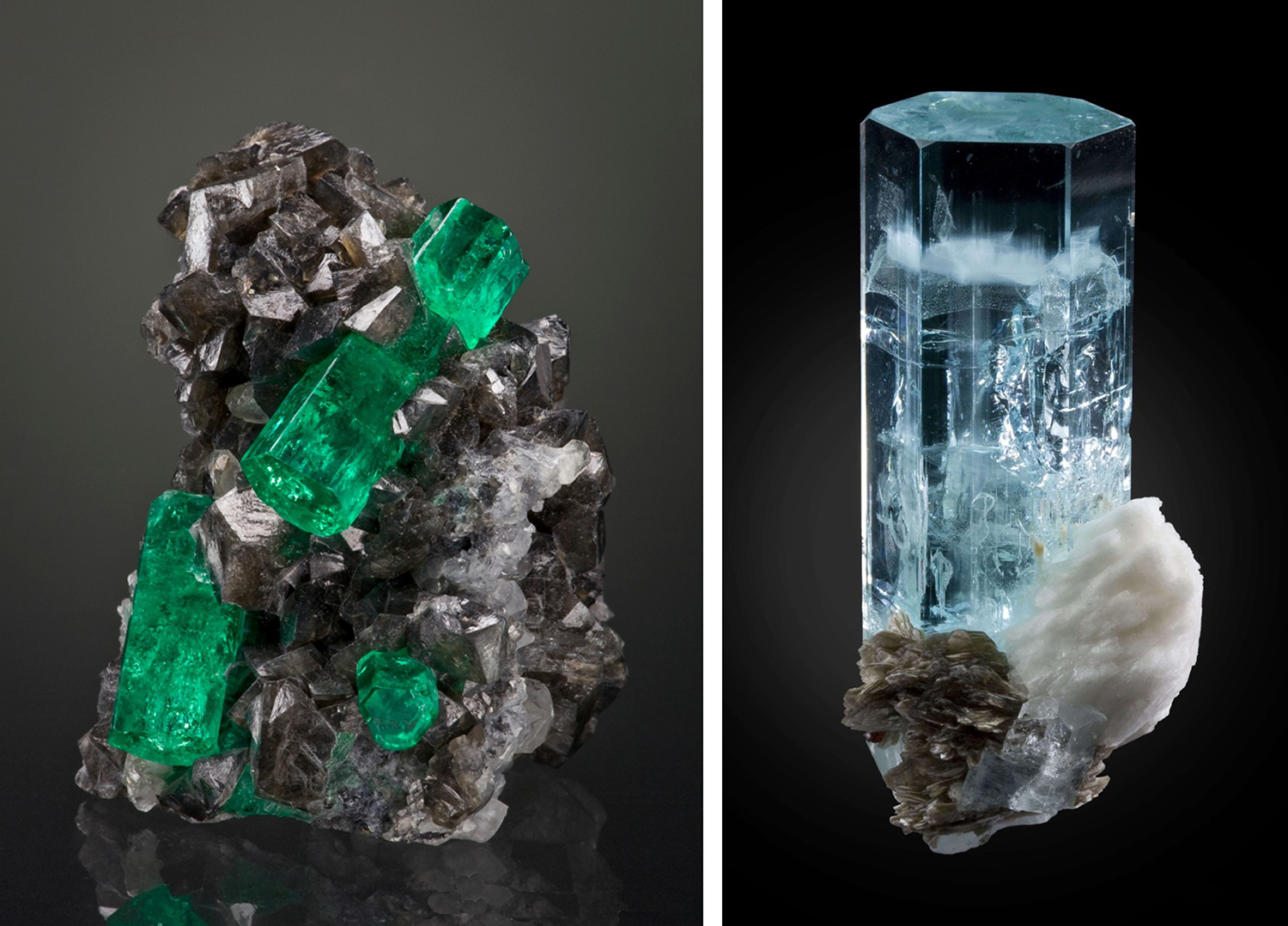
Pegmatites may be sources of spectacular mineral specimens that grace museum collections. Figure 7.24 is a photo of an example – a spectacular sample of beryl with quartz from Brazil. Figure 7.25 shows two more examples of pegmatitic beryl. The green beryl is from Columbia and the blue beryl is from Pakistan. Beryl comes in many different colors having different varietal names. The green specimens in Figures 7.24 and 7.25 are emeralds, the blue specimen in Figure 7.25 is aquamarine. Besides beryl, pegmatites often contain other beautiful mineral specimens, including various varieties of lepidolite, chrysoberyl, tourmaline, and topaz.
High concentrations of uncommon elements mean that some pegmatites can be valuable ore bodies. Some pegmatites yield profitable ores producing lithium, beryllium, and boron. Some are mined for zirconium, tin, tungsten, and rare earth elements. Additionally, because they often contain large euhedral crystals, pegmatites can be important sources of gemstones – including emerald, aquamarine, tourmaline, topaz, fluorite, apatite, ruby, and sapphire. However, mining is typically short lived due to the small sizes of most pegmatites, but may be lucrative.
7.4.4 Mafic Dikes and Sills

Dikes and sills range from silicic to mafic compositions, but the most common are mafic. And the most common and widespread kinds of mafic intrusions are dikes. Most mafic dikes and sills consist of diabase (a fine-grained equivalent of gabbro and basalt). This photo (Figure 7.26) shows a dark-colored diabase dike cutting, from left to right, through light-colored granite at Schoodic Point in Acadia National Park, Maine. Mafic dikes, such as the one shown, are fed by magmas of mantle origin. Some dikes are the conduits for rising magmas that feed erupting volcanoes or that erupt as flood basalt.
Mafic intrusions may involve a single intrusive event or multiple intrusions, or pulses, of the same kind of magma. Others form from multiple intrusions of magmas having different compositions. Mafic dikes commonly branch, and some get directed along rock layers to create sills. In many places, dikes cut across ancient igneous and metamorphic rocks, appearing to continue forever and disappear into the distance, as shown in Figure 7.26.
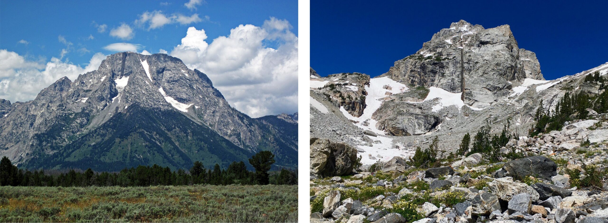
Individual mafic dikes or sills are widespread. Often, they are in sharp color-contrast with the country rocks around them. They may weather and erode differently from surrounding rock, sometimes making them especially easy to pick out. Figure 7.27 contains views of Mt. Moran and Middle Teton in Grand Teton National Park on the Idaho-Wyoming border. Both have vertical black diabase dikes cutting through their peaks. The dike on Mt. Moran is 45 meters wide; the one on Middle Teton is considerably smaller – 5 to 10 meters wide. The erosion resistant diabase is one reason the peaks are so tall.
Mafic sills, like mafic dikes, are quite widespread, but, because they are typically horizontal and conform with surrounding country rock, they are more difficult to notice. Often, only their top surface can be seen. Some are quite large and easily mistaken for basalt flows. The Palisades Sill (about 300 meters thick), which makes up the New Jersey Palisades on the Hudson River near New York City, is a diabase sill. Its outcrops resemble a columnar basalt in some places, so it was originally mistaken for a lava flow (Figure 7.28).
7.4.5 Mafic Dike Swarms
Mafic dikes intrude along fractures, so in regions where there are many fractures, there may be many dikes in dike swarms. Dike swarms can cover vast regions and include hundreds of individual dikes that are of about the same age. They may be arranged in linear, parallel, or radiating patterns. Most are Precambrian, which many geologists interpret to be due to an overall hotter Earth at that time that allowed large volumes of mafic magma to make it more easily from the mantle into the crust.

The Mackenzie Dike Swarm, one of several dozen dike swarms in the Canadian Shield, is the largest dike swarm in the world. It covers a huge area of the Shield – more than 500 kilometers wide and 3,000 kilometers long – from near the Great Lakes to the Arctic (Figure 7.29). The dikes make a fan-like pattern and all seem to radiate from a point on southern Victoria Island in the Arctic. Most petrologists believe that a large mantle plume carried heat and magma up in that region. The rising plume caused the crust to fracture, providing conduits for dike formation. The Muskox layered mafic intrusion, the Coppermine River and Ekalulia flood basalts, and several major plutonic complexes were all emplaced in the region at the same time – additional evidence for an active mantle plume that provided magma for both plutonic and volcanic rocks.
| Chapter 16 Section 16.1 contains many photos of plutonic rocks in hand specimen and in thin section. If you want to know what they look like, go there. |
7.5 Feldspar-Bearing Plutonic Rocks
Most popular web sites and books describe Yosemite Valley, and the nearby High Sierras, as being made of granite. This word is often used loosely to refer to any light-colored coarse crystalline rock, but the term has a more restricted definition to geologists. Much of the rock in the valley walls does not fit a geologist’s definition of granite, and the rocks are not the same everywhere. Many geologists duck the semantic problem and call Yosemite rocks granitic, or as granitoids. These terms are generally understood to refer to any light-colored plutonic rock composed primarily of quartz and feldspar (either alkali feldspar or plagioclase), although occasionally there is debate about whether the term can be used to refer to rocks such as syenite that contain minimal quartz.
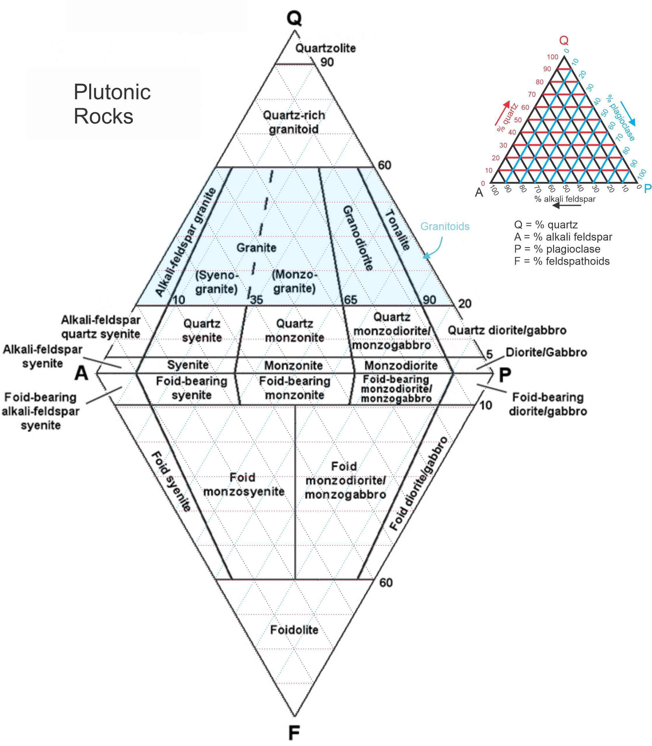
The International Union of Geological Sciences (IUGS) developed a widely used standardized classification system and nomenclature for plutonic rocks. Most common plutonic rocks fall into the IUGS subsystem for phaneritic feldspathic rocks shown in Figure 7.30. It is similar to the classification system for volcanic rocks presented in Chapter 4.
The IUGS system seen in Figure 7.30, called the QAPF classification system, is based on the relative amounts of quartz (Q), alkali feldspar (A), plagioclase (P), or feldspathoids (F) that a rock contains. The QAPF system applies to all plutonic rocks that contain more than 10% total quartz and feldspar (alkali feldspar or plagioclase). The IUGS uses the general term granitoid for any rock that contains feldspars and 20-60% quartz (blue in Figure 7.30).
The QAPF diagram for plutonic rocks has two triangular parts. The top triangle is for rocks that contain quartz, and the bottom (upside down) triangle is for rocks that contain feldspathoids (generally leucite or nepheline). Rocks that contain quartz never contain feldspathoids and vice versa, so it is generally clear which half (top or bottom) of the diagram to use. Due to coarse grain size of plutonic rocks, it is often possible to estimate QAPF proportions while examining outcrops or hand specimens – something generally not possible for volcanic rocks. More accurate determinations can be made by examining a rock in thin section with a petrographic microscope.
As modifiers to rock names, the IUGS suggests using the prefixes mela- (meaning dark colored) and leuco- (meaning light colored) when appropriate. A melagabbro, for example is a gabbro that has a darker color than most gabbros, and a leucogranite is a granite that has a lighter color than most granites.
7.5.1 Quartzofeldspathic vs Ferromagnesian Intrusive Rocks
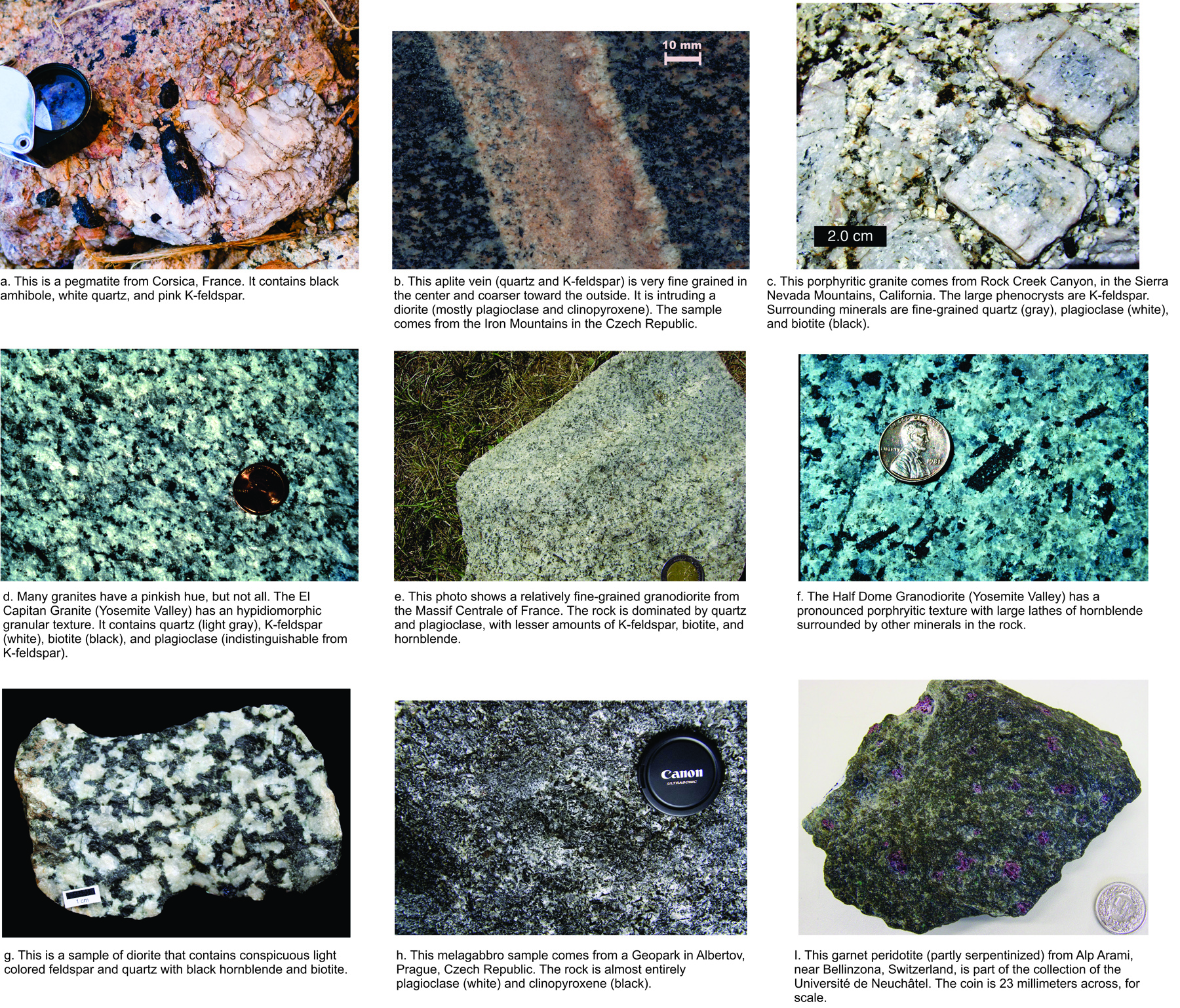
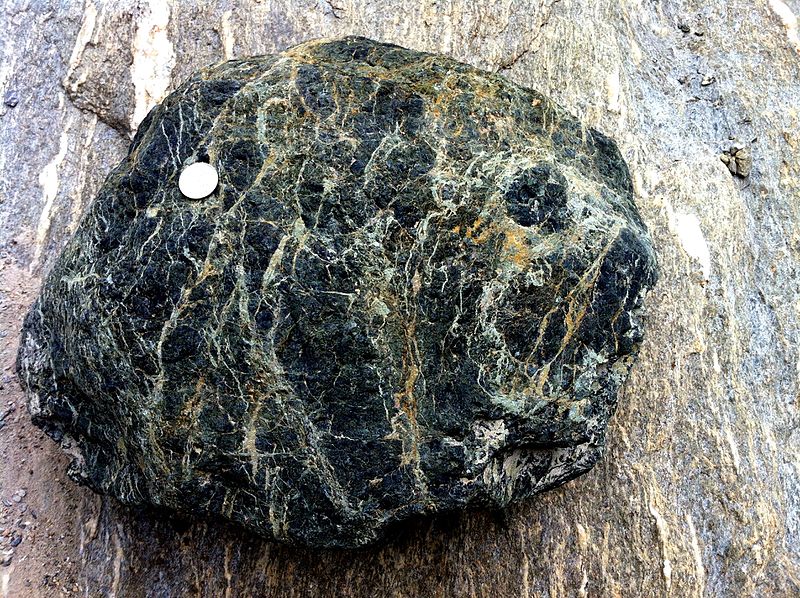
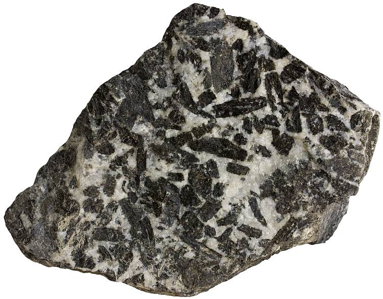
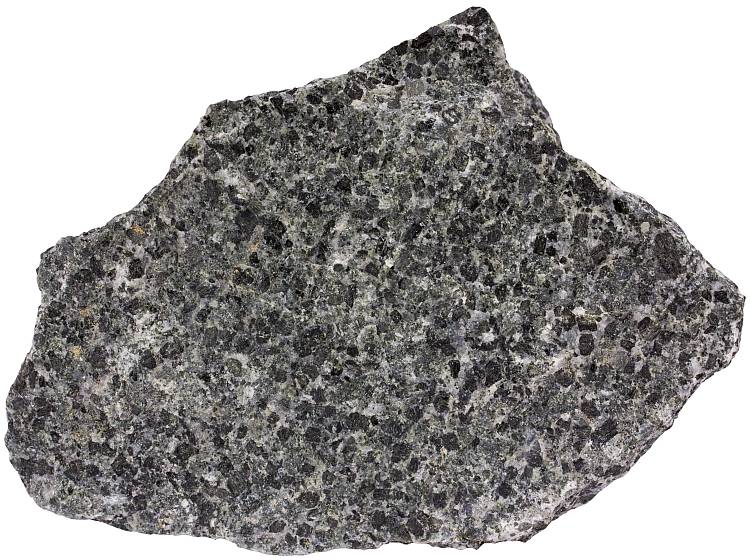
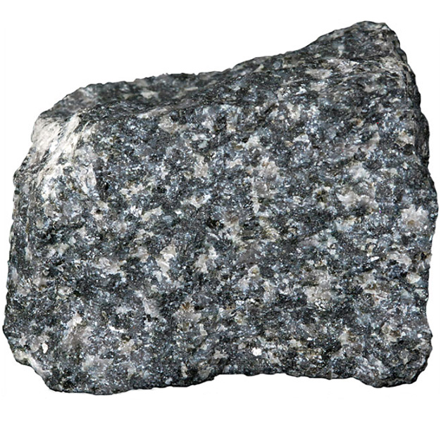
The opening photo in this chapter shows a large outcrop (Stone Mountain, in Georgia) made of plutonic rock (quartz monzonite). Figure 7.31 contains close-up photographs of some typical plutonic rocks in hand specimen; many are from the Yosemite region. Petrologists often divide plutonic rocks into two basic groups: quartzofeldspathic rocks and ferromagnesian rocks. Quartzofeldspathic rocks, commonly light colored, are made mostly of combinations of quartz and feldspar (alkali feldspar or plagioclase) with lesser amounts of biotite and hornblende, but the proportions vary greatly. Ferromagnesian rocks, commonly dark colored, are made mostly of ferromagnesian minerals, chiefly pyroxene, olivine, and, perhaps amphibole. All the rocks seen in Figure 7.31 are quartzofeldspathic, except the gabbro (h) and the garnet peridotite (i).
The most common quartzofeldspathic rocks include granite, granodiorite, tonalite, monzonite, and quartz diorite. Alkalic plutonic rocks, containing K-feldspar with little plagioclase and little or no quartz, have compositions equivalent to volcanic trachyte and phonolite. They are uncommon and mostly found in rare alkaline rock complexes such as the one at Magnet Cove, Arkansas. These rocks are, however, very important sources of rare earth elements and other uncommon metals.
The basic QAPF classification system for plutonic rocks, depicted in Figure 7.30, works well for silicic and intermediate quartzofeldspathic rocks but not well for mafic rocks that contain plagioclase and little quartz or alkali feldspar (and so plot near the P corner in Figure 7.30). These plagioclase-rich rocks include diorite, gabbro, norite, and anorthosite. So, distinguishing diorite from gabbro, for example, must be based on one or more of the following: (1) plagioclase composition (in diorite, plagioclase is Na-rich; in gabbro, it is Ca-rich), (2) the ferromagnesian minerals present (hornblende or biotite in diorite; clinopyroxene, orthopyroxene, or olivine in gabbro), (3) the generally darker color that gabbro has compared with diorite, or (4) the speckled black and white appearance of common diorite. Furthermore, the QAPF system is not applicable to ferromagnesian rocks that contain no feldspar or quartz. Consequently, the IUGS created separate, but still triangular, naming systems for gabbroic rocks, including gabbro, norite, and anorthosite, and for ultramafic rocks (discussed later).
7.5.2 A Closer Look at the Southeast Face of El Capitan

7.32 Geological map of the vertical southeast face of El Capitan, Yosemite Valley, California
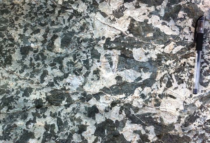
The southeast face of El Capitan, seen earlier in Figure 7.2, provides a fascinating view of many different kinds of plutonic rocks that can be found in the Yosemite region and in batholiths overall. Putnam et al. (2014) created a geologic map of the 914-meter precipice, identifying more than half a dozen distinctive rock types (Figure 7.32). To compile the map, Putnam made many trips up and down the face, gathered information from rock climbers who visited places he did not, took high resolution photographs from the valley floor, and used laser topographic scans to measure the shape of the face.
Because some kinds of rocks weather and erode more rapidly than others, rocks exposed in outcrops at Earth’s surface often give a highly biased indication of the bedrock below. Additionally, due to soil and vegetation, the contacts between different rock units may be difficult to see. The map of El Capitan avoids these problems because it is a map of a vertical slice through a batholith instead of outcrops at the surface.
Putnam et al’s map reveals that El Capitan is a complicated mix of several major plutonic rock types that cut across and through each other. Table 7.3 summarizes the overall composition. About 2/3 is granite, mostly the 106 million-year-old El Capitan Granite. 15% of El Capitan is the Taft Granite which crops out mostly in the upper portions of the face and intrudes into the El Capitan Granite. So, the Taft Granite is younger than the El Capitan Granite. The still younger Leaning Tower Granite (about 2% of the face) cuts both of the others. Of the non-granitic rocks, 14% of the face is a gray tonalite; it is found mostly between the Taft Granite and the El Capitan Granite. 15% of the face is the North American Diorite, so named because part of this dark rock appears shaped like North America. About 5% of the rocks exposed in the face are in dikes. Some are narrow and made of fine-grained aplite or pegmatite (both granitic); others are wider, blobbier, and composed of diorite or granodiorite. The different rocks can be distinguished by slightly different colors and textures (Table 7.3).
| Table 7.3. The rocks that make up the Southeast Face of El Capitan, Yosemite Valley, California, and appear as map units in Figure 7.27. All these rocks are about 100 million years old. In this table, they are ordered from youngest (at the top) to oldest (at the bottom). | |||
| southeast face area % | map unit | description | mineralogical composition |
| 2 | aplite and pegmatite dikes | white to light-gray; generally fine-grained; locally coarse | quartz and alkali feldspar with rare accessory garnet and muscovite |
| 15 | North American Diorite | dark gray to black; fine to medium-grained | plagioclase and augite with accessory biotite and hornblende |
| 2 | Leaning Tower Granite | medium to dark-gray; medium to fine-grained; commonly contains 1-5 centimeter clots of biotite or other mafic minerals | quartz and alkali feldspar with accessory biotite |
| < 1 | pegmatite bodies | white to light-gray; coarse-grained granite | quartz and alkali feldspar |
| 14 | tonalite of gray bands | medium to dark gray; medium to fine grained | mostly quartz and plagioclase, but biotite and minor hornblende are common |
| 3 | dikes of oceans | medium to dark-gray; medium to fine-grained diorite to granodiorite | mineralogically variable; plagioclase rich with K-feldspar and quartz; typically biotite rich and hornblende poor |
| 14 | Taft Granite | light-gray; medium to fine-grained; equigranular (not porphyritic) | Quartz and k-feldspar dominate; biotite averages 3% |
| 49 | El Capitan Granite | light-gray; medium to coarse-grained; commonly porphyritic (alkali feldspar phenocrysts up to 2 centimeters) | Mostly quartz and K-feldspar with lesser plagioclase; biotite < 10% |
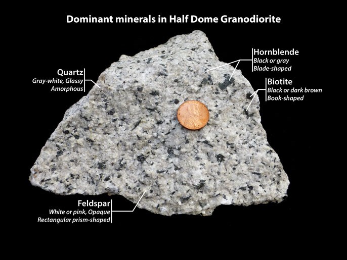
The rocks comprising El Capitan are typical of the entire Yosemite region and of the Sierra Nevada Mountains overall. Yosemite is a mosaic of many different intrusive bodies that formed over millions of years, including some additional rock types not seen in El Capitan’s face. For example, Figure 7.33 is a sample of the Half Dome Granodiorite. This rock crops out just a few kilometers east of El Capitan on the north side of the valley in the Royal Arches and North Dome. The Royal Arches are prominent in Figure 7.5; North Dome is the rounded peak above the Arches. This granodiorite also crops out on the opposite side of the valley from the Arches, at Glacier Point. Farther east, it forms the vertical cliff face of Half Dome itself, seen on the right in Figure 7.5. The granodiorite is medium to coarse-grained and contains conspicuous plates of biotite and crystals of hornblende. It is the youngest of the major plutonic rocks in the region. The granite, granodiorite, tonalite, quartz monzonite, and quartz monzodiorite found in Yosemite are all granitoids, which explains why sometimes the imprecise name granite is used for all of Yosemite’s rocks.
7.6 Mafic and Ultramafic Rocks
Previous discussions in this chapter have been mostly about quartzofeldspathic rocks. Such rocks make up most large plutons, batholiths, and many dikes. And we name these rocks using the QAPF system described above.

In contrast with quartzofeldspathic rocks, various combinations of plagioclase, clinopyroxene, orthopyroxene, and olivine dominate mafic and ultramafic plutonic rocks. They generally lack K-feldspar and quartz, rendering the QAPF system inapplicable. As shown in Figure 7.34, we classify mafic and ultramafic rocks based on proportions of plagioclase, pyroxene, and olivine. We call those that are mostly plagioclase anorthosites; those that are mostly pyroxene and olivine are ultramafic rocks. Rocks that are mostly pyroxene and plagioclase, or pyroxene and plagioclase with olivine, are gabbroic rocks.
Accessory amphibole, generally hornblende, and biotite may also be present in mafic rocks, but not in most ultramafic rocks. Olivine, an essential mineral in many ultramafic rocks, is absent or only an accessory in mafic rocks. Especially silica-rich gabbro may contain small amounts of quartz. Other gabbro, deficient in silica, may contain feldspathoids such as nepheline, analcite, or leucite. In both mafic and ultramafic rocks, apatite, magnetite, ilmenite, and several other minerals are common in very minor amounts.

Figure 7.34 depicts the general IUGS system for differentiating mafic and ultramafic rocks. The IUGS developed a more specific system for naming gabbroic rocks, rocks consisting mostly of one or two pyroxenes and plagioclase. These are rocks that plot near the left side of the triangle in Figure 7.34. This naming system (Figure 7.35), is based on the proportions of plagioclase, clinopyroxene (generally augite), and orthopyroxene. Gabbro contains mostly plagioclase and clinopyroxene, norite contains mostly plagioclase and orthopyroxene, and rocks between are gabbronorite.
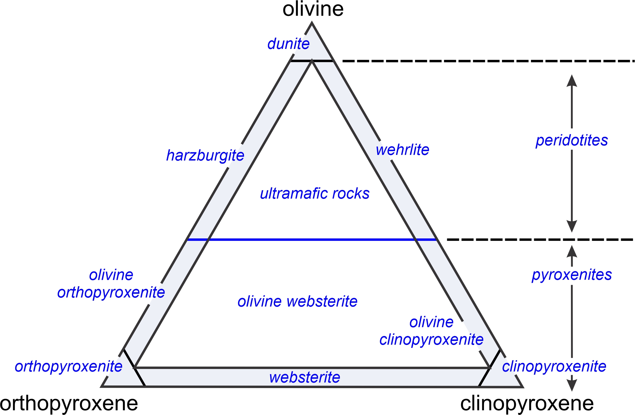
The IUGS uses the proportions of olivine, orthopyroxene, and clinopyroxene to differentiate different kinds of ultramafic rocks – rocks that plot near the bottom of the triangles in Figures 7.29 and 7.35. Figure 7.36 shows the system. Peridotites, which are rocks containing more than 50 weight % olivine, include harzburgite (mostly olivine and orthopyroxene), wehrlite (mostly olivine and clinopyroxene), and lherzolites (subequal amounts of orthopyroxene and clinopyroxene). Pyroxenites may be orthopyroxene-rich (orthopyroxenite), clinopyroxene-rich (clinopyroxenite), or contain similar amounts of both pyroxenes (websterite). We put the modifier olivine in front of a pyroxenite name if a rock contains more than 5% olivine. A different triangular diagram (not shown) is used for the rare ultramafic rocks that contain hornblende.

Mafic and ultramafic magmas can crystallize in the same way that their more silicic cousins (granitic and intermediate magmas) crystallize. A magma body may cool slowly to produce a large rock body of uniform composition and texture. Often, however, the first formed mineral crystals settle to the bottom of a magma chamber, producing cumulates. Less commonly, early formed plagioclase may float to the top of a magma chamber and accumulate.
Cumulate minerals include high-temperature minerals such as chromite, olivine, pyroxene, or Ca-rich plagioclase. No matter how they form, these minerals eventually become surrounded by a matrix composed of lower-temperature finer-grained mineral crystals. Figure 7.37 is a photo of a cumulate from the Stillwater Complex, Montana. The dominant brown crystals are cumulus orthopyroxene. White plagioclase has filled space between. The less abundant green crystals are intracumulus augite.
Very fine-grained plutonic rocks may be hard to distinguish from volcanic rocks. For example, a hand sample of aphanitic gabbro, called diabase, also called dolerite, may be indistinguishable from (volcanic) basalt. However, most mafic and ultramafic plutonic rocks are phaneritic, containing crystals millimeters across or larger. These rocks are usually equigranular but may be porphyritic. Some gabbros, for example, contain very large plagioclase phenocrysts surrounded by groundmass. Rarely, mafic and ultramafic rocks are exceptionally coarse-grained and pegmatitic.
Mafic and ultramafic magmas crystallize in steps over a range of temperature. Consequently, lower-temperature minerals (e.g., augite, hornblende, or pyroxene) may fill spaces between earlier-formed euhedral high-temperature minerals (e.g., olivine, spinel, or magnetite). Plagioclase is often the last mineral to crystallize and, consequently, may fill interstices between larger Fe- and Mg-rich mineral crystals. In some rocks, however, especially some diabase and gabbro, plagioclase crystallizes first and becomes incorporates as inclusions in later-formed pyroxene. Although plagioclase and pyroxene dominate mafic rocks, lesser amounts of amphibole, olivine, oxides, and other minerals may also be present. anchor
If smaller grains of an early formed mineral are completely enclosed by larger later formed mineral crystals, the rock has a poikilitic texture. The most common type of poikilitic texture, an ophitic texture, is found in some diabase and gabbro when plagioclase crystallizes first and randomly oriented plagioclase lathes are trapped in later formed pyroxene. This cobblestone (Figure 7.38) from Lausitz, southeastern Germany, shows an exceptionally well-developed ophitic texture. The white lathes are plagioclase, and the surrounding dark material is clinopyroxene.
7.6.1 Occurrences of Mafic Plutonic Rocks
Mafic plutonic rocks, generally simply called gabbros, or gabbroic rocks, are not as abundant as granitic rocks, but gabbroic rocks are more widespread. Gabbroic rocks, containing 45-52 weight % SiO2 and subequal amounts of FeO and MgO, have compositions equivalent to the volcanic rock basalt. Different varieties of these mafic rocks vary slightly in mineralogy and chemical composition depending on their origin. True gabbros contain abundant essential plagioclase and augite (clinopyroxene); other gabbroic rocks contain orthopyroxene instead of clinopyroxene. Characterizing accessary minerals include olivine and amphibole. Gabbroic rocks typically contain small amounts of other accessory minerals too.
The oceans comprise 362 million square kilometers of Earth’s surface – 71% of our planet. Ocean waters are underlain by oceanic crust up to 10 or 15 kilometers thick, and that crust is almost entirely made of gabbro, such as the rock shown in Figure 7.31h. So, gabbro is arguably the most common rock type in Earth’s crust, and most gabbro on Earth is created by decompression melting at mid-ocean ridges. Less commonly, we see gabbro on continents, in plutons related to continental volcanism.
Basaltic volcanism occurs when mafic magma makes it to the surface in a continental region. Sometimes, however, magma stalls, producing large volumes of gabbro that crystallize in magma chambers that later may be uplifted and exposed at the surface by erosion. The connection between mafic magma chambers – perhaps later to become plutons – and mafic volcanism is well established. Figure 7.39, for example, is a photo of gabbro outcrops on Meall Meadhonach, a hill in northernmost Scotland. Nearby basalt occurrences of about the same age suggest that the same mafic magma may have produced both plutonic and volcanic rocks.
Gabbros are also found in the lowermost levels of flood-basalt terranes, such as the Columbia River flood basalts of the northwestern United States and the Deccan Traps of India. There, thick sequences of basalt flows accumulated and the flows on the bottom cooled slowly enough to become coarsely crystalline; thus, the magma became gabbro instead of basalt. Still other gabbros are found associated with ultramafic rocks in layered igneous complexes, including the Stillwater Complex of Montana and the Bushveld Complex of South Africa.
Because they generally contain abundant mafic minerals (pyroxene and sometimes hornblende or olivine), and at most very small amounts of quartz, most gabbroic rocks are dense and moderately to darkly colored. Mafic minerals are mostly unstable at Earth’s surface, and commonly hydrate to form chlorite or serpentine and other green or greenish minerals. So sometimes, especially when weathered, mafic rocks have a greenish hue.
7.6.2 Occurrences of Ultramafic Plutonic Rocks
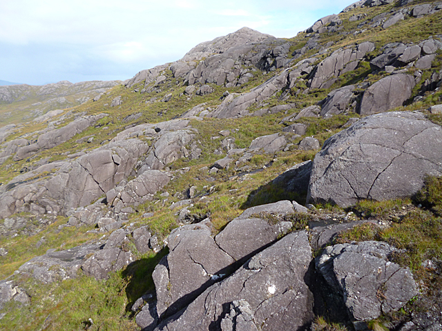
Ultramafic plutonic rocks (for example, peridotites and pyroxenites) that formed during the Phanerozoic Eon (younger than Precambrian) are rare, and Phanerozoic ultramafic volcanic rocks are even rarer. This is because, as discussed in Chapter 4 (Section 4.6.1), Earth has cooled since the Precambrian. So, ultramafic magmas – which once could make it to the surface – crystallize before they can rise to shallow depths. Most peridotites and pyroxenites are found in layered igneous complexes that originated deep within Earth. Outcrops of these rocks are rare, but we find them as blocks exposed in outcrops of mountain belts or in the eroded roots of mountain belts exposed in Precambrian shields.
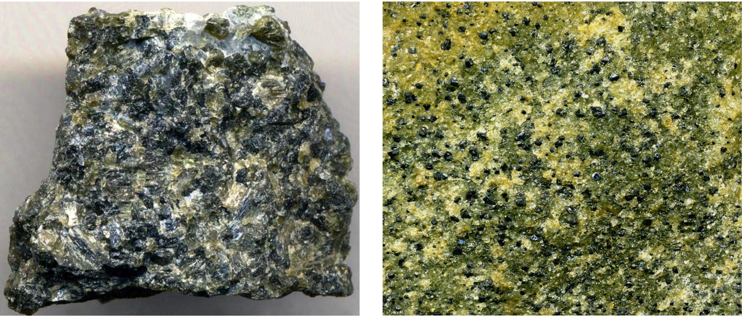
Ultramafic rocks, because they are mostly made of mafic minerals, are typically dark colored (if unaltered), but some peridotites are light green because they contain abundant olivine. The peridotites in Figure 7.40 both contain green olivine. The harzburgite on the left also contains a great deal of dark colored orthopyroxene. The lherzolite on the right, besides olivine, contains darker green clinopyroxene. The darkest-colored grains in this rock are chromite and orthopyroxene but the two cannot be easily distinguished in this photo. Figure 7.31i shows a different peridotite that contains garnet.

Because ultramafic rocks are quite unstable at Earth’s surface and near-surface, they often alter to produce green serpentinites. Typical serpentinites contain one of the serpentine minerals (antigorite, lizardite, or chrysotile) with ancillary chlorite, brucite, magnetite, and sometimes talc. These minerals form when (anhydrous) olivine and pyroxene react with water. Figure 7.41 shows an outcrop of typical serpentinite near San Francisco. These rocks were once part of the ocean floor but were obducted onto the North American continent. Most serpentinites, even if not green, have a dark color due to the presence of abundant magnetite. Figure 2.24 shows another example of serpentinite – a sample from the Maurienne Valley of France. anchor
7.6.3 Layered Mafic Intrusions
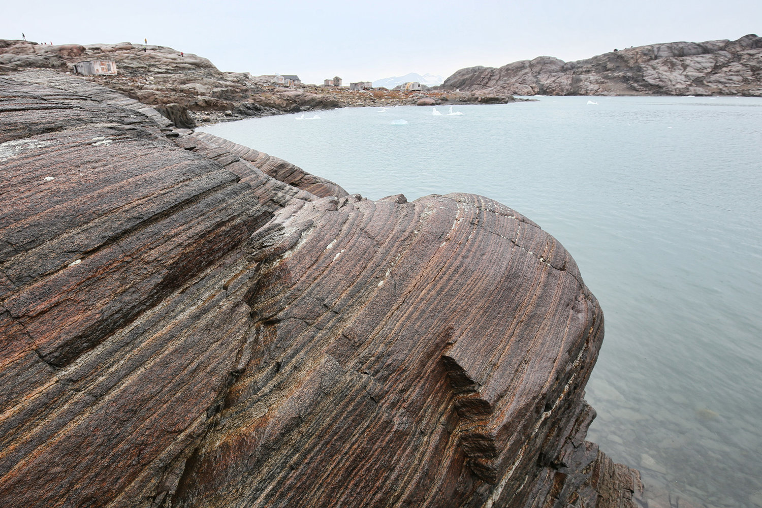
Figure 7.42 is a photo of an outcrop of ultramafic rock in the Skaergård Complex of Eastern Greenland. The Skaergård is an example of a layered mafic intrusion (LMI). LMIs are plutonic complexes containing mafic and ultramafic rocks. They form from multiple intrusions, and range in size from quite small (like the Skaergård Complex) to very large. These complexes can be found in just about every geological setting (Table 7.4). Most are lopoliths, funnel shaped intrusive bodies with flat upper surfaces (Figure 7.12). The majority of LMIs are Precambrian, but some famous ones, including the Skaergård and Dufek intrusions, are much younger. The complexes all formed over long times, estimated to be as long a million years in some cases. Many, but not all, layered mafic intrusions are associated with flood basalts of similar age.
| Table 7.4 Some of the Most Studied Layered Mafic Intrusions | |||
| Complex Name | Geologic Age & Time of Formation |
Location | area (km2) |
| Bushveld | Precambrian 2 billion years ago |
South Africa | 66,000 |
| Dufek | Jurassic 184 million years ago |
Antarctica | 50,000 |
| Duluth | Precambrian 1.1 billion years ago |
Minnesota USA |
4,700 |
| Stillwater | Precambrian 2.7 billion years ago |
Montana USA |
4,400 |
| Muskox | Precambrian 1.2 billion years ago |
Northwest Territories Canada |
3,500 |
| Skaergård | Eocene 56 million years ago |
Greenland | 100 |
The largest layered mafic intrusion is the Bushveld Complex, a large lopolith in South Africa near Johannesburg. Figure 7.43 is a cross-section of the complex. The layered intrusion, with an area of more than 66,000 square kilometers, covers 15% of South Africa. It is up to 10 kilometers thick in places. The complex contains near-horizontal horizons of different compositions. Most are ultramafic and many are cumulates.
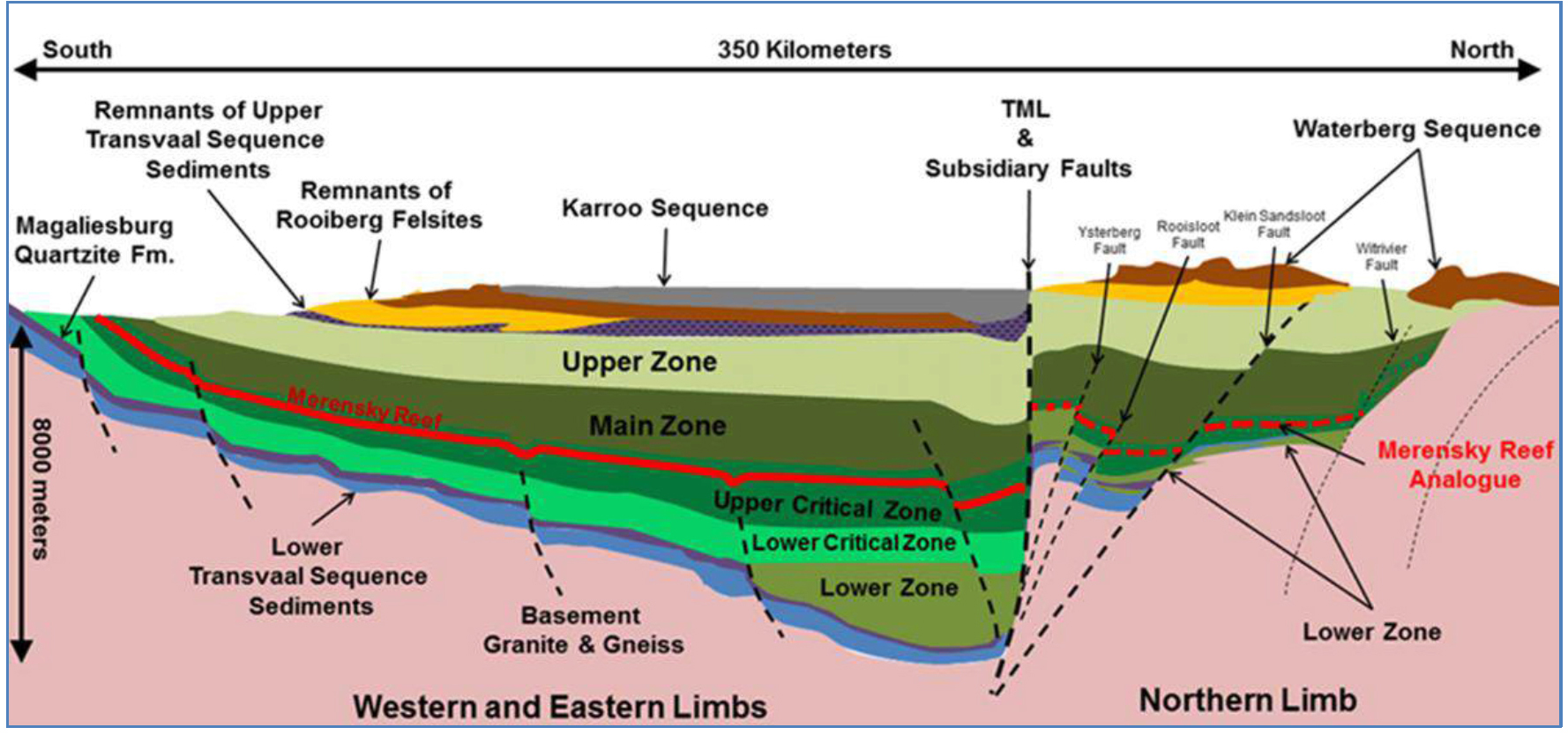
Layered mafic complexes include typical mafic and ultramafic rocks, and sometime intermediate or silicic rocks. The complexes are characterized by multiple intrusions and fractionation due to cumulate formation. A generic model has ultramafic rocks (both peridotites and pyroxenites) at the bottom of the complex grading into mafic rocks (norites, gabbros, and anorthosites) higher up – with perhaps intermediate and silicic rock bodies at the top. However, sometimes the sequences repeat, some rock compositions are missing, or there has been significant deformation after emplacement – making the geometry difficult to interpret. The Bushveld complex has peridotite, harzburgite, orthopyroxenite, and chromite cumulates near its base, with norite, anorthosite, and gabbro above. A several kilometers thick layer of granitic rocks is found at the very top.
Layered mafic complexes are important natural laboratories. By studying them geologists have answered some key questions about fractionation, and how Earth differentiated over time. Field investigations of the spectacular rocks in these complexes have confirmed what was known from laboratory experiments – that magmas evolve as igneous minerals crystallize over a range of temperature in predictable order.
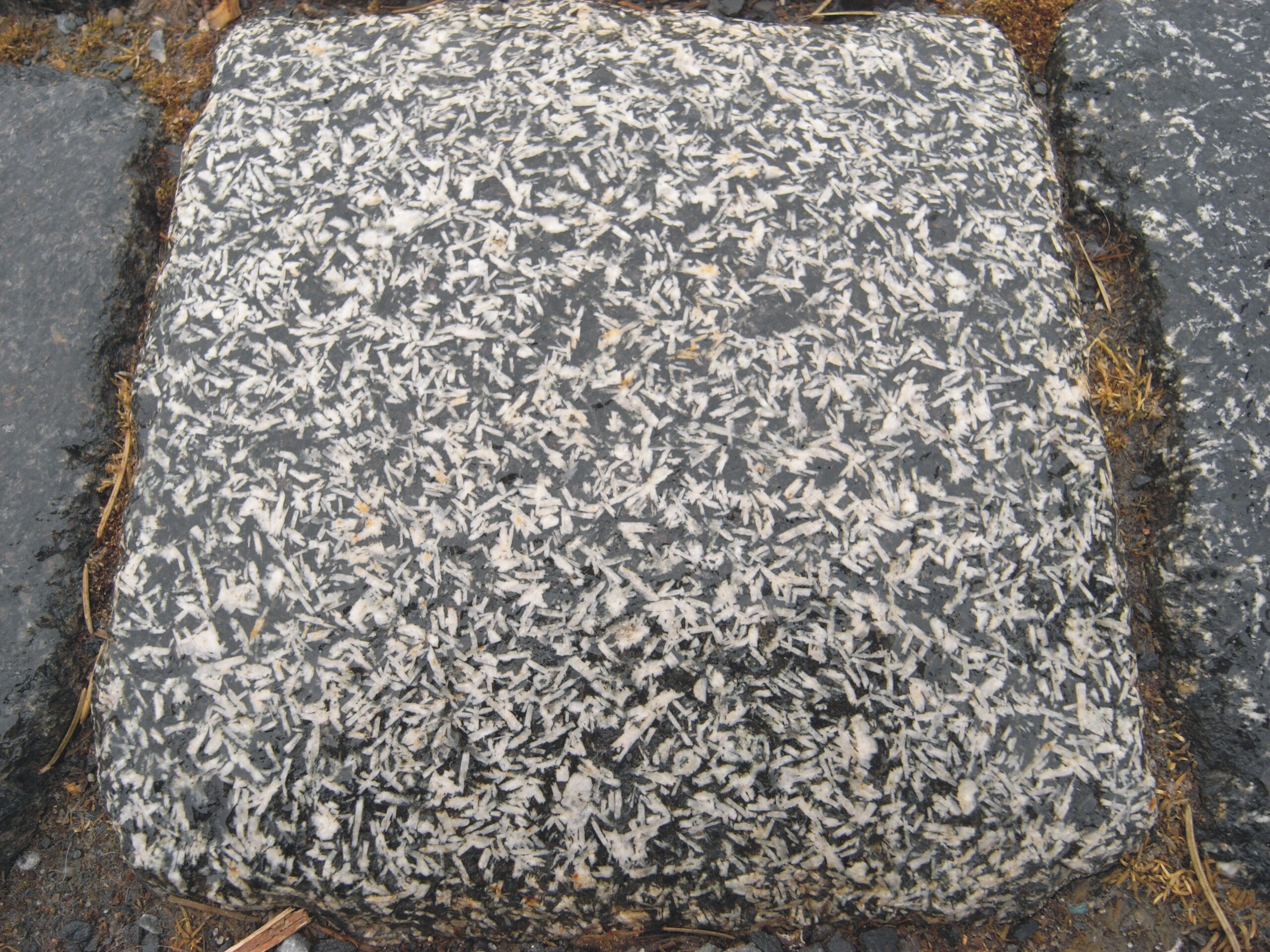
Layered complexes are also important for the ore bodies they contain. In some complexes, chromite and other oxide and sulfide mineral cumulates provide rich concentrations of chromium, platinum group elements, titanium, and vanadium. For example, the Merensky Reef of the Bushveld complex is a 30 to 90 centimeters thick layer of norite that includes cumulate sulfide and chromite layers. The reef appears as a red line in Figure 7.43 but its size has been greatly exaggerated. The Merensky Reef produces chromium, but more importantly contains most of the world’s known reserves of platinum, palladium, and several other key industrial elements. Gold, silver, and copper are produced as ancillary products.
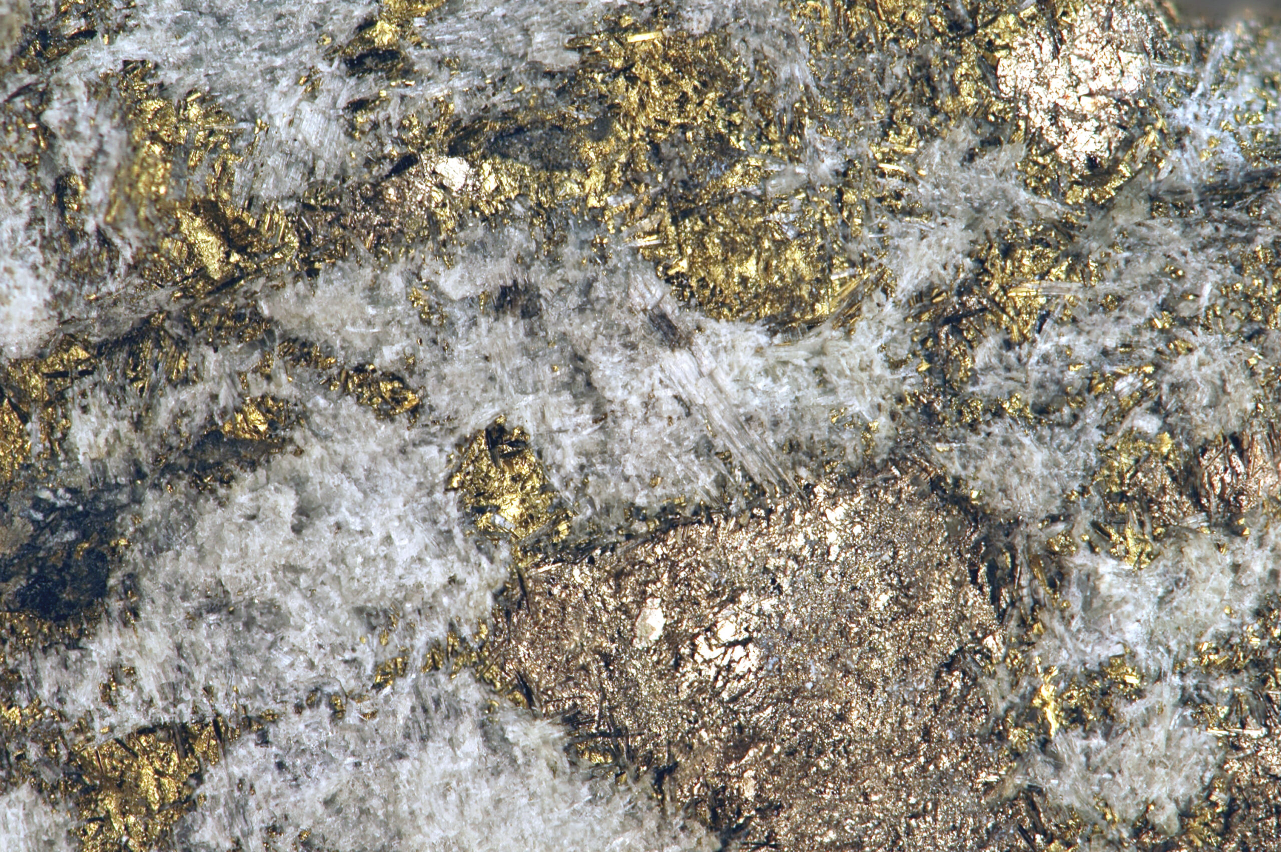
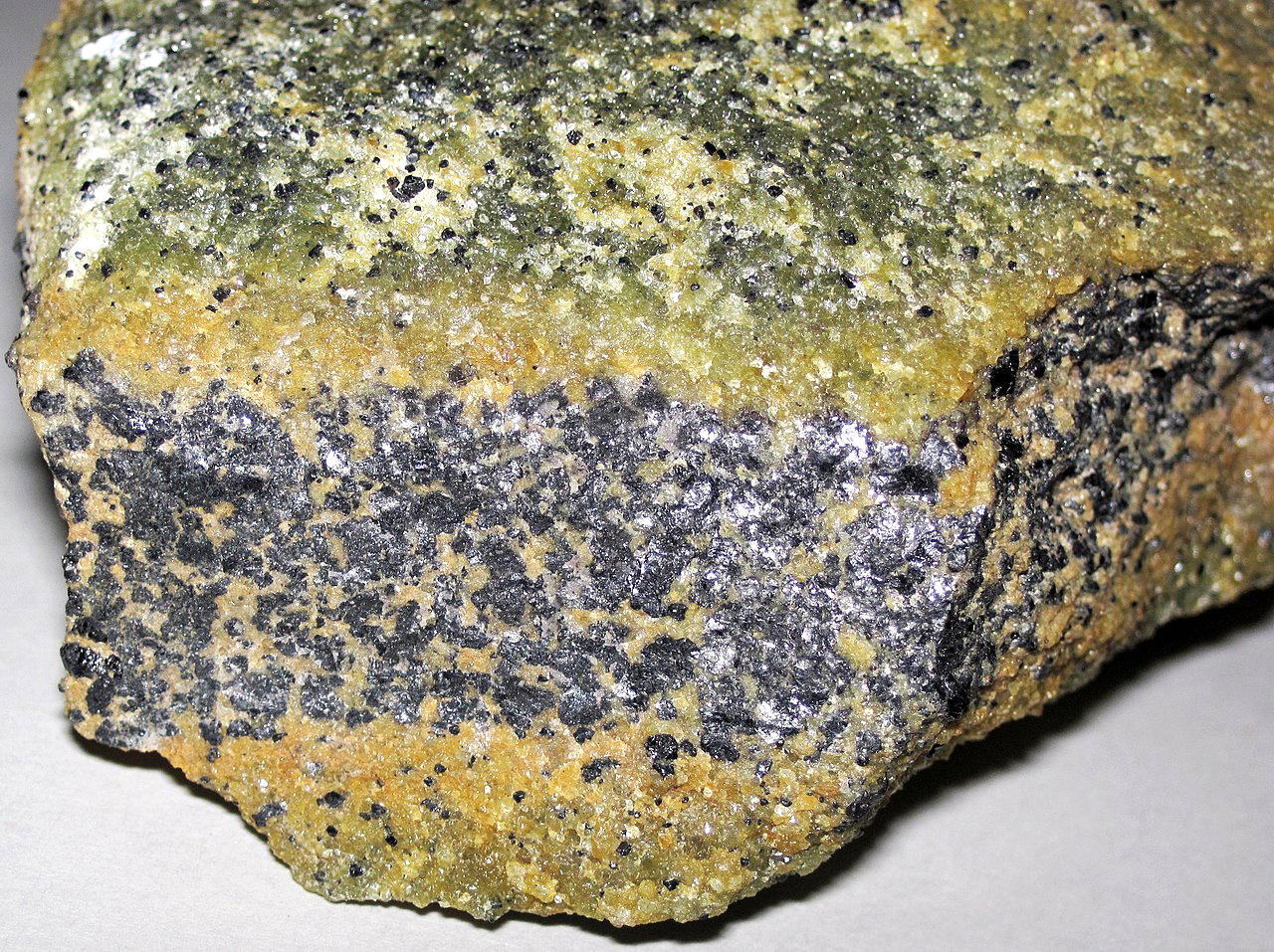
The Stillwater Complex, a layered mafic complex in Montana, contains the J-M Reef, an ore body similar too, but smaller than, the Merensky Reef. The J-M Reef is a one- to three-meter thick body of altered ultramafic rock that contains pockets of very high-grade platinum and palladium ore. The photo in Figure 7.44 shows ore rock taken from the reef. This ore rock contains light-colored tremolite, golden chalcopyrite, and bronze pyrrhotite. The chalcopyrite and pyrrhotite are the targets of mining because they contain exceptionally high amounts of platinum and palladium.
7.6.4 Anorthosites
Anorthosites are a distinctive kind of rock that contains more than 90% plagioclase. Layers of anorthosite are common in layered mafic complexes. The anorthosite in Figure 7.45 is an example from the Duluth Complex in eastern Minnesota. The gray coarse crystals are all plagioclase and the black mineral between them is augite. Besides being in layered complexes, anorthosites also form in other settings as separate plutons, and they sometimes make up large batholiths. Archean anorthosites, common in shield areas, range from small dikes or sills to plutonic bodies more than 100 square kilometers in area. In these anorthosites, the plagioclase is always Ca-rich. Archean anorthosites are typically associated with mafic and ultramafic intrusions including gabbros and peridotites. Massif anorthosites, which differ from Archean anorthosites, also occur as large plutons or batholiths. In these anorthosites, however, plagioclase has intermediate composition instead of being Ca-rich. Additionally, associated mafic or ultramafic rocks are rare or absent.
7.7 A Closer Look at Plutonic Rock Textures
7.7.1 Grain Size and Shape
Above we discussed many different kinds of plutonic rocks. Most were named on the basis of their compositions. Yet, different plutonic rocks with similar compositions may have many different appearances. The appearance of a rock depends, in part, on rock composition and mineralogy. Additionally, however, many different textures can develop depending on how a rock forms. Some rocks have distinct textures because of their constituent grain sizes or grain shapes. Other distinct textures develop because of the way grains fit together or, perhaps, because of the textural relationships between grains of different minerals. And, on a smaller scale, individual mineral grains may develop textures of different sorts.
Below we look at examples of the most common textures and discuss the terms used to describe them. We introduced some of these terms earlier in this chapter. Now we discuss textures in more detail and look at many photo examples. Besides the terms introduced in this chapter, other textural terms, described in the discussion of volcanic rocks in Chapter 4 (Section 4.5.2), sometimes apply to plutonic rocks, too.
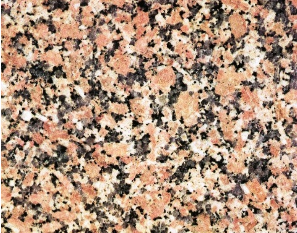
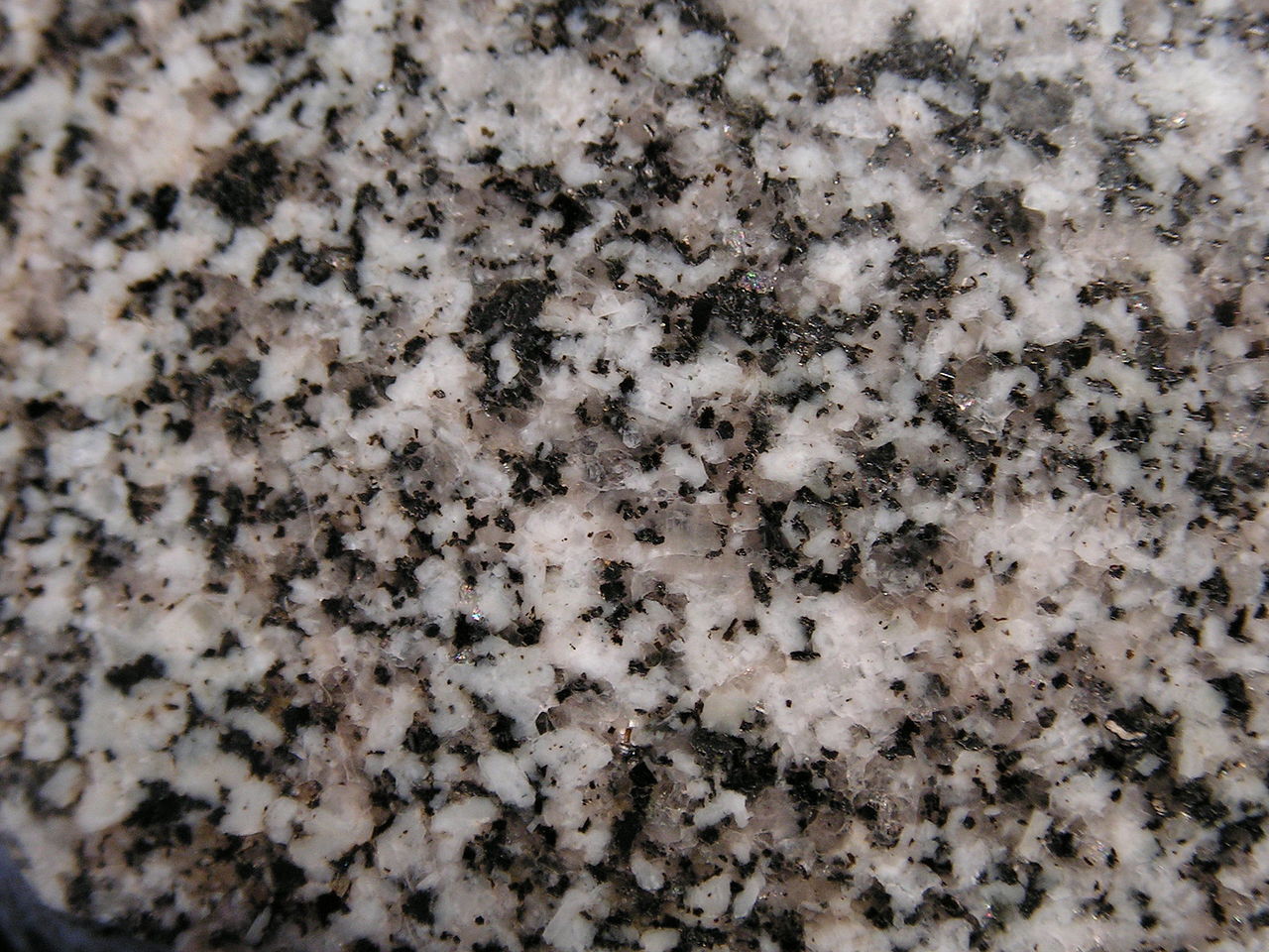
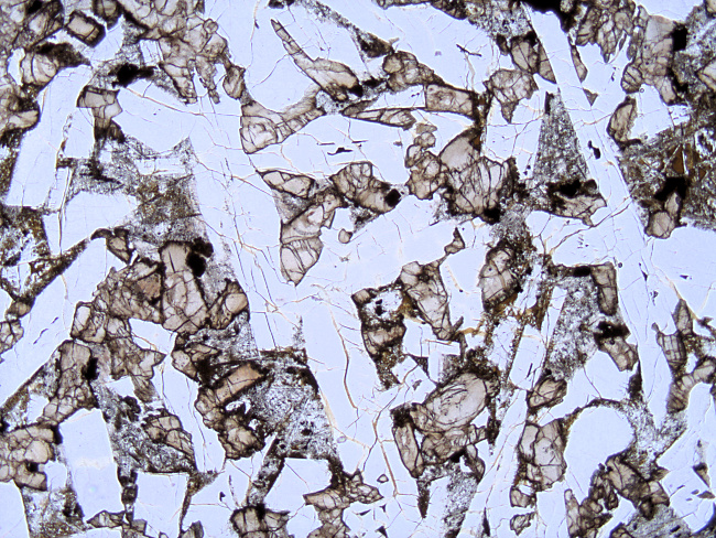
Some plutonic rocks are equigranular, sometimes just described as being granular, containing grains that are all about the same size. The diorite seen in Figure 7.46 is an example. It contains crystals of plagioclase, quartz, hornblende, and biotite that are all about the same size. Other rocks are inequigranular, containing grains that range considerably in size. Figure 7.47 is a photo of an inequigranular granite from the Giants Range Batholith in northern Minnesota. Large pinkish grains of K-feldspar dominate the rock. Smaller black and white minerals are quartz, plagioclase, and biotite.
Whether equigranular or not, plutonic rocks vary in grain size. They range from fine-grained aplites, diabases, and other rocks, to coarse-grained pegmatites. We discussed both pegmatites and aplites in more detail previously (Section 7.4.3). Fine-grained rocks consist of grains with average diameters less than 1 mm; medium-grained rocks contain grains with average diameters of 1-5 mm, and coarse-grained rocks contain grains with average diameters greater than 5 mm.

Most plutonic rocks are relatively coarse-grained, largely because the slow cooling rates of intrusive rocks generally lead to large crystals. For example, Figure 7.48 is a photo of the Mt. Blanc granite near Martigny, Switzerland. This granite contains large blocky orthoclase crystals surrounded by slightly smaller crystals of plagioclase and quartz. Figure 7.49 is a photo of an even coarser rock, a pegmatite outcrop on the Island of Corsica, France. Figure 7.21, earlier in this chapter, shows an example of a narrow pegmatite vein containing large crystals. Pegmatites are coarse because of slow cooling, but also because pegmatite magmas contain large amounts of water and sometimes other volatile components. The volatiles act as fluxes that readily transport atoms to growing crystals. The pegmatite above in Figure 7.49 is relatively fine grained compared with many other pegmatites. Some contain crystals several to many meters across.
Most pegmatites are granitic, but not all. For example, the photo in Figure 7.50 is a gabbroic pegmatite from the Troodos Massif of Cyprus. The major minerals are dark-gray clinopyroxene and light-colored plagioclase. Some of the mineral crystals are more than 15 cm long.

At the other end of the size spectrum, the finest-grained plutonic rocks, such as some aplites or diabases, contain grains of millimeter size or smaller. Petrologists use the term aplitic to describe any fine- to medium-grained igneous rock made primarily of equigranular anhedral crystals. Sometimes we describe this texture as sugary. Figure 7.51 is a photo of an aplite dike (top of photo) cutting through quartz monzonite (bottom) at Butte, Montana. Figure 7.20, earlier in this chapter, shows a narrower aplite vein.
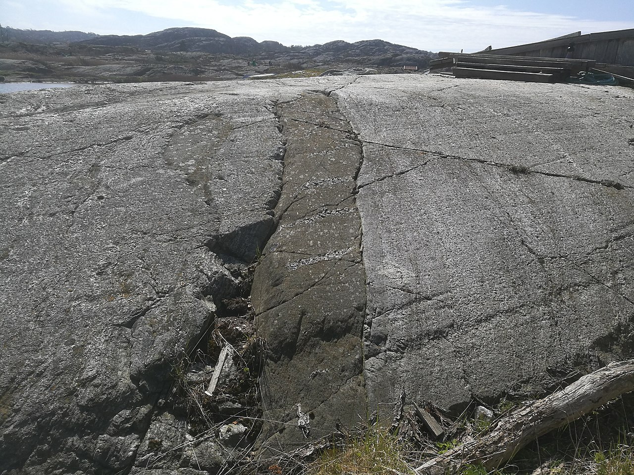
Figure 7.52 shows another fine-grained plutonic rock, a diabase dike near Björnshuvudet on the west coast of Sweden, 300 km south of Oslo, Norway. Most of the finest-grained plutonic rocks are in dikes because dikes cool very quickly, leaving little time for crystals to grow large. Sills, too, may consist of fine-grained plutonic rock for the same reason. Dikes and sills, however need not be as thin as the dike in Figure 7.52. Figure 7.27, earlier in this chapter, shows dikes, many meters wide, in the Teton Mountains. And Figure 7.28 is a photo of the thick Palisades Sill in New York.
Igneous mineral crystals may be euhedral, subhedral, or anhedral. If most crystals in a rock are euhedral, the rock is idiomorphic. Idiomorphic rocks are, however, rare. Many plutonic rocks have a hypidiomorphic texture – they are a mix of euhedral, subhedral, and anhedral grains. This texture is typical of granites; common granites contain anhedral crystals quartz and K-feldspar with subhedral plagioclase and biotite. Figure 7.53 shows a hypidiomorphic granite from Monforte, Portugal. The largest grains in the rock are centimeter-sized salmon-colored subhedral K-feldspar. A few euhedral laths of plagioclase are also present, but most of the mineral grains are subhedral or anhedral. The granite in Figure 7.47 also has a hypidiomorphic texture but the grain size varies between different minerals. Hypidiomorphic rocks that contains grains all about the same size are sometimes described as being hypidiomorphic-granular. Figure 7.31d shows an example, a hypidiomorphic-granular granite.
If most grains are anhedral, a rock has an allotriomorphic texture. Allotriomorphic rocks are more common than idiomorphic or hypidiomorphic rocks. Figure 7.54 is a photo of an allotriomorphic granodiorite. Figure 7.46 is a photo of allotriomorphic diorite. In these kinds of rocks, late-forming mineral crystals are constrained and take the shape of the space where they crystallize. In the granodiorite (Figure 7.54), the smoky gray quartz crystals were the last to form. They are xenomorphic crystals, meaning their shape is an artifact of their surroundings during crystallization.
Plutonic rocks, like volcanic rocks, may be porphyritic, containing large phenocrysts in a finer-grained matrix. Figure 7.48, earlier in this section, showed an example of porphyritic granite. Figures 7.31c and 7.31f show other porphyritic rocks. In porphyritic volcanic rocks, the matrix is often very fine-grained or microscopic. In porphyritic plutonic rocks, the matrix is generally phaneritic. In either case, finer matrix surrounds coarser phenocrysts. If the phenocrysts in a porphyry are unusually large, we call them megacrysts. Figure 7.55 shows feldspar megacrysts in a granite from Brittany, France.
Plutonic rocks may also contain xenocrysts, large crystals, sometimes megacrysts, that did not crystallize from the parent magma but instead were incorporated from surrounding country rocks. Xenocrysts may be hard to distinguish from phenocrysts unless they have compositions making them unusual minerals to find in the host rock.
Figures 7.56 and 7.57 show two examples of porphyritic gabbros. These gabbros, both from Tangen, Norway, contain black phenocrysts of augite surrounded by matrix plagioclase. The gabbro in Figure 7.56 contains centimeter-long phenocrysts of augite. The gabbro in Figure 7.57 contains more equant, and much smaller augite phenocrysts. Figure 7.58 is a photo of another gabbro, one that is more typical. This gabbro is phenocryst-free, equigranular, and allotriomorphic.
7.7.2 Textures Involving Mineral Intergrowths or Inclusions
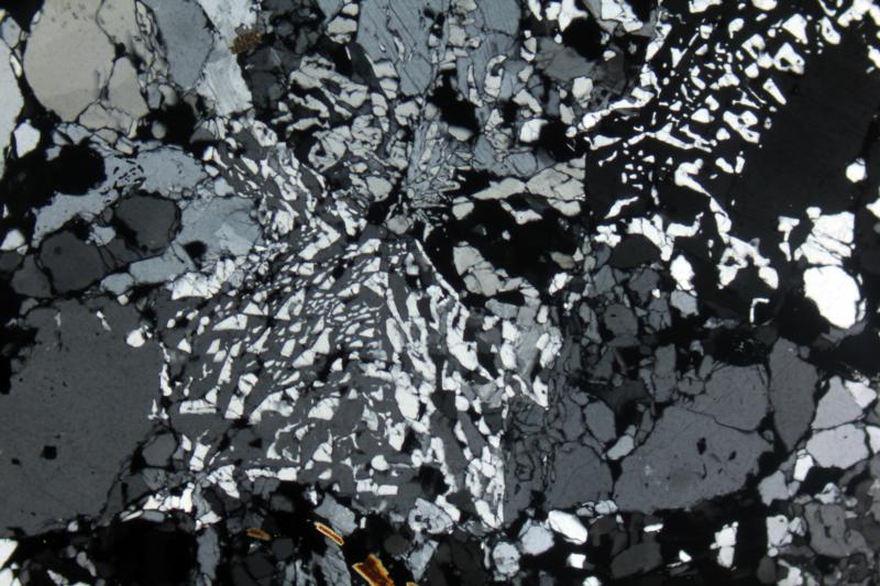
Many plutonic rock textures are difficult to see in hand specimen but easily seen in thin section. Poikilitic textures are one example. We briefly discussed poikilitic texture above in Section 7.6. In poikilitic mineral grains, smaller grains of one mineral are completely enclosed in large grains of a different mineral. The larger mineral grains are oikocrysts. Poikilitic textures develop when one kind of mineral crystallizes first and space around the early-formed crystals becomes filled by a second mineral.
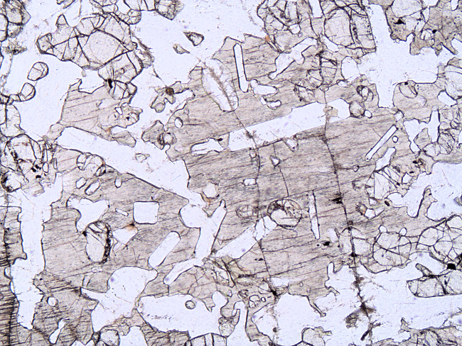
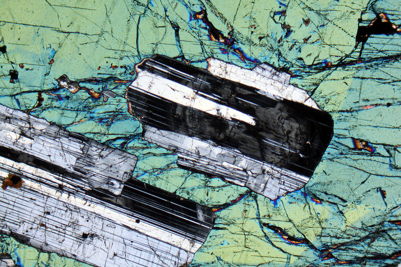
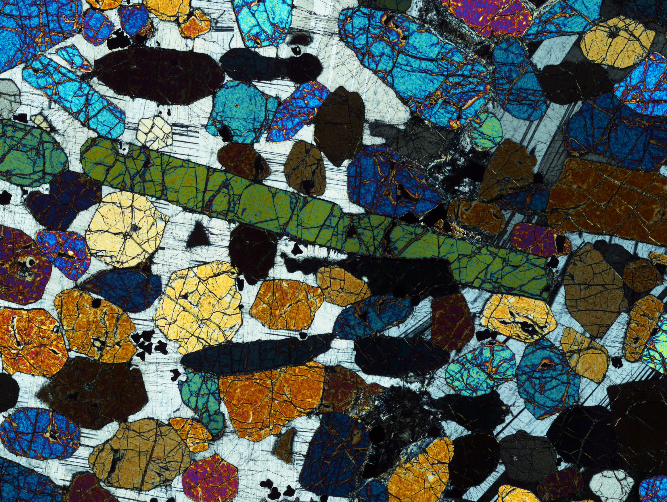
Figures 7.59 and 7.60 show two thin-section views of poikilitic augite surrounding plagioclase inclusions. In Figure 7.59, a crossed-polars view, augite has bright green-blue interference colors and gray plagioclase shows diagnostic lamellar twins. In Figure 7.60, a plane-polarized view, plagioclase appears as clear laths and augite is darker colored with higher-relief. Both of these views are 7 mm across, making the poikilitic crystals easy to see. The texture, however, is common at a much finer scale.
The photos in Figures 7.59 and 7.60 are of a specific variety of poikilitic texture called ophitic texture. This texture is common in diabases, gabbros, and diorites. In ophitic rocks, pyroxene (or less commonly olivine) surrounds laths of plagioclase because plagioclase crystallized first and pyroxene (or olivine) subsequently filled remaining space. The cobblestone in Figure 7.38 shows ophitic texture visible at the outcrop scale.
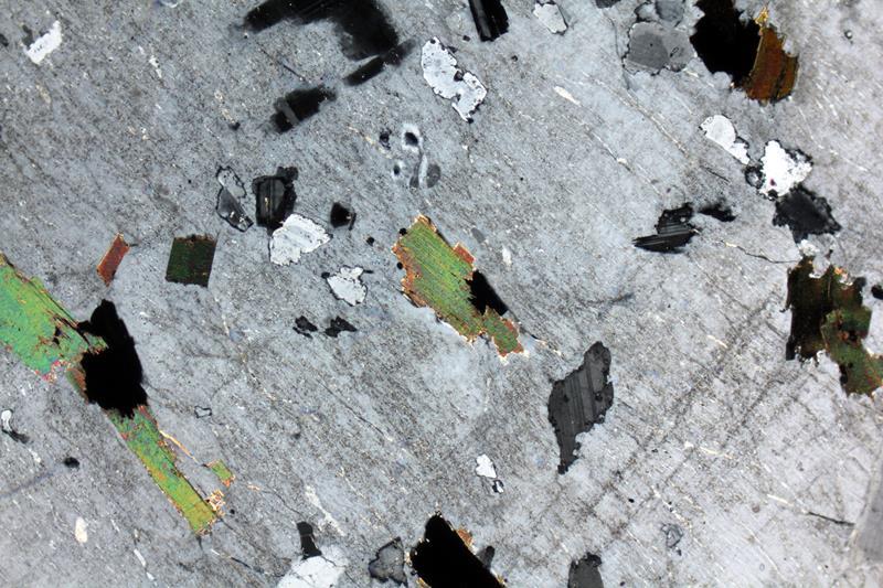
Figure 7.61 is a crossed-polars thin-section photo that is mostly poikilitic orthoclase (gray interference color). The orthoclase contains hard to see exsolution lamellae. It also includes small crystals of biotite, plagioclase, and magnetite. Small plagioclase crystals have white to gray interference colors and some show faint twinning that can be seen if the photo is enlarged. Biotite has green and other second- and third-order interference colors, and the opaque magnetite grains appear black. Poikilitic orthoclase typifies many syenites and monzonites.
The general term intergranular refers to any texture in which mafic or oxide minerals occupy angular interstices between plagioclase grains. Ophitic textures are one example; subophitic textures are another related texture. In rocks with subophitic textures, plagioclase crystals are large and in contact, and angular spaces between plagioclase crystals contain pyroxene. The photomicrograph in Figure 7.62 shows an example. In this plane-polarized view, clear laths of plagioclase have created a framework with irregular-shaped openings between them. Pyroxene and minor glass occupy the openings. Figure 7.45 shows an example of a subophitic anorthosite.
Some rocks develop cumulate textures when early-formed crystals settle to the bottom of a magma chamber. Subsequently, groundmass made of other minerals fills the space between the cumulate grains. If a rock is nearly entirely cumulate minerals, with little groundmass (<7%), we call it an adcumulate. Mesocumulates contain greater amounts of groundmass (7-15%) and orthocumulates even more (>15%). Figure 7.63 is a thin-section view of an olivine mesocumulate. In this photo, the grains with colorful interference colors are all olivine. Black (opaque) grains are chromite, and the gray matrix in the background is plagioclase.
The photo in Figure 7.64 shows an ultramafic cumulate rock from Montana’s Stillwater Complex. Green layers are altered olivine and the metallic gray mineral is cumulate chromite. These minerals collected in layers at the bottom of a magma chamber as ultramafic magma crystallized. Figure 7.37 is a photo of a different Stillwater cumulate rock, one that contains cumulate orthopyroxene.
For other examples of cumulates: Figure 7.43 is a photo of cumulate layers in an outcrop of ultramafic rock in Greenland’s Skaergård Complex. This rock was tilted after horizontal cumulate layers formed. Figure 3.29 is a photo of chromite-rich cumulate layers in the Bushveld Complex.
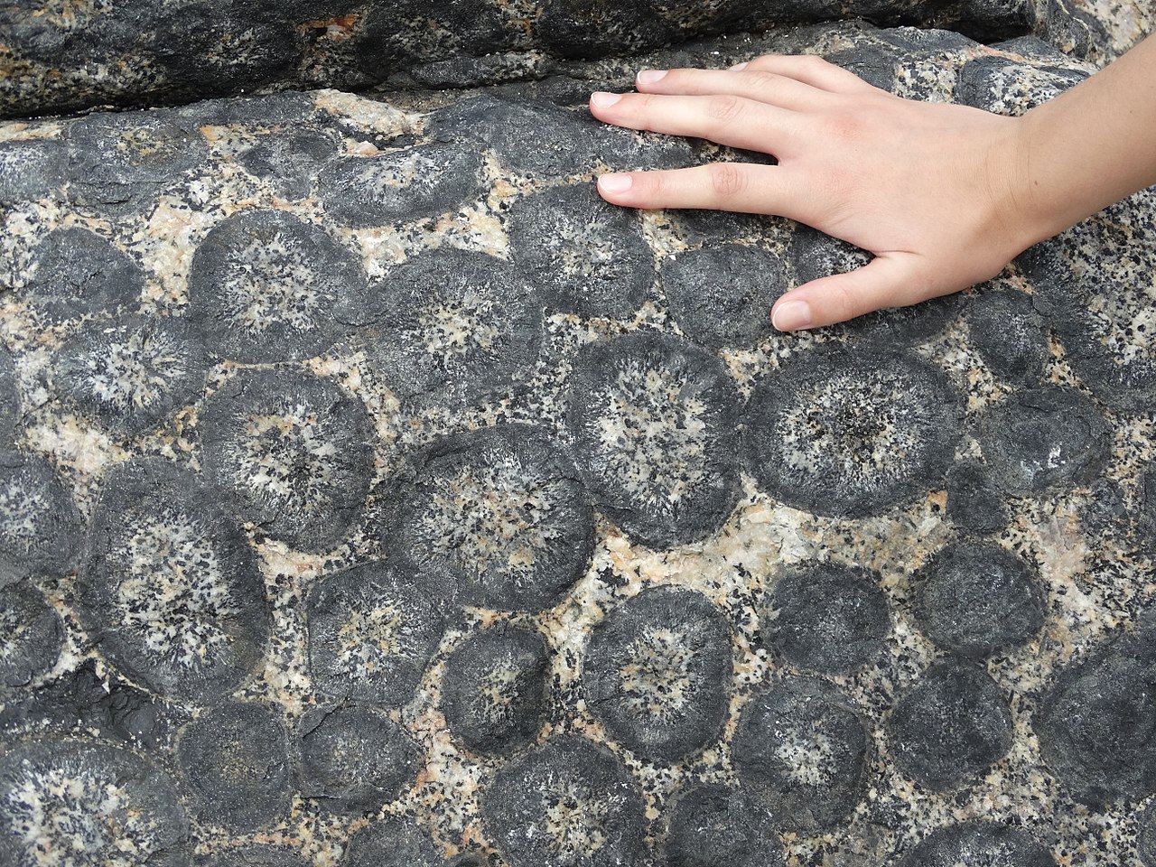
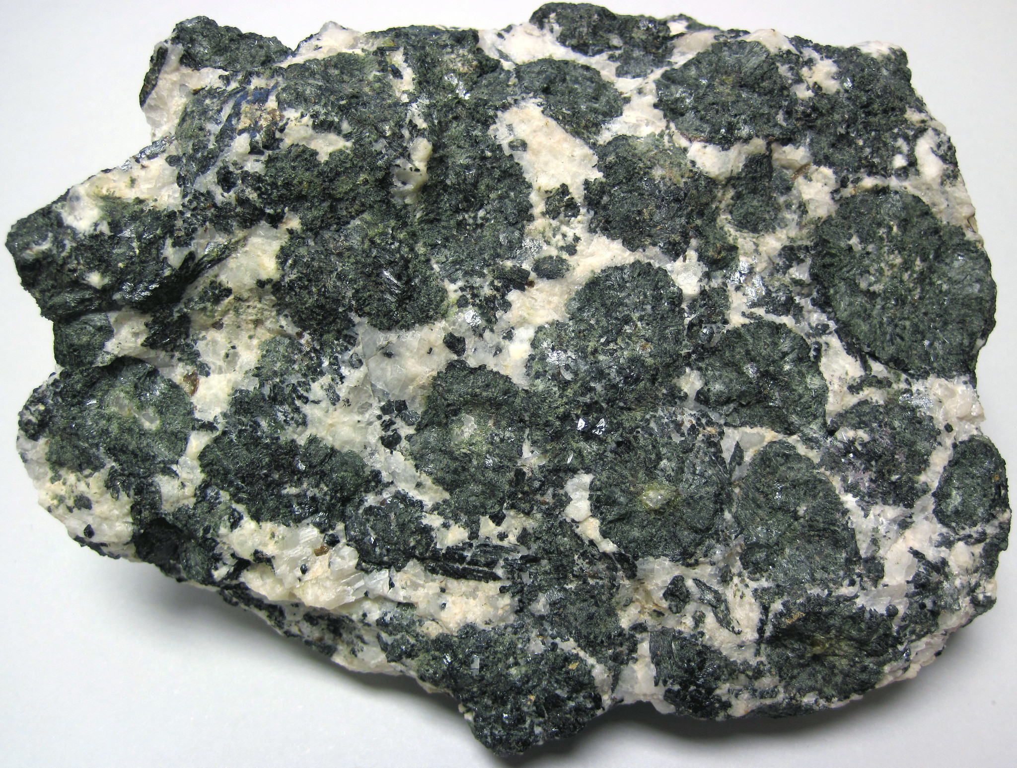
Orbicular plutonic rocks contain orbicules. Orbicules, which may be up to about 10 cm in diameter, are round, sometimes distorted, structures with contrasting concentric layers. They form as crystallization occurs around seed grains when a magma experiences rapidly changing conditions during cooling. Figure 7.65 is an example of orbicular granite from Chile. The orbicules consist of radiating hornblende, clinopyroxene, and plagioclase crystals. Most orbicular rocks are granitic, but Figure 7.66 shows one with a slightly different composition -an orbicular monzodiorite. The dark orbicules in this monzodiorite contain hornblende and clinopyroxene. The surrounding matrix comprises plagioclase, microcline, and quartz.
Sometimes mineral crystals begin to form and later separate into two separate compositions, forming two separate intergrown minerals that are coarse enough to see at the hand-sample scale. For example, some granitic rocks develop graphic textures. Graphic textures are most common in pegmatites. These textures consist of intergrowths of quartz and K-feldspar. Petrologists sometimes describe graphic intergrowths as runic or cuneiform (because the intergrowths look like characters in ancient alphabets). Often the quartz appears as V-shaped inclusions in the feldspar, such as in the rock seen in Figure 7.67.
7.7.3 Mostly Microscopic Textures
We use the terms micrographic and granophyric to describe fine-grained textures similar to graphic textures that are only visible with a microscope. The terms mean about the same thing. The photo in Figure 7.68 shows an example. It is a crossed-polars thin-section view of a granite with K-feldspar crystals that contain many wormy quartz inclusions. Micrographic textures may be fine-grained equivalents of the texture seen above in Figure 7.67. In contrast, granophyric textures often appear to involve radiating crystals. Graphic, micrographic, granophyric, and related textures are thought to form by simultaneous crystallization of two minerals from a hydrous silicate melt.

Myrmekitic texture, generally only seen in thin section, often appears similar to graphic texture but involves intergrowths of quartz and plagioclase instead of quartz and K-feldspar. Figure 7.69 shows an example. Myrmekitic grains contain worm-like stringers of quartz, typically smaller than a millimeter across, in larger plagioclase crystals. This texture, unlike graphic and granophyric textures, is metasomatic rather than magmatic. It is common in granites.
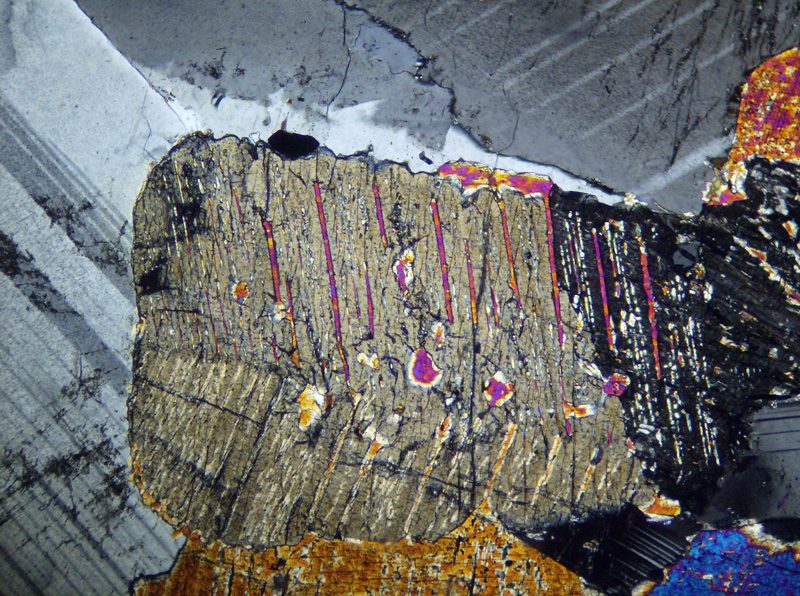
Sometimes minerals that form at high temperature become unstable and exsolve into two separate compositions at lower temperature after a mineral has crystallized. This can result in separate grains with different compositions, or in a single exsolved grain that contains lamellae (narrow regions) of different minerals. Many different minerals may exhibit exsolution. Figure 7.70, a crossed-polars thin-section view, shows exsolution in pyroxene. The large grain that occupies most of the thin section is an originally high-temperature augite crystal that exsolved upon cooling. It now contains thin stripes of pigeonite exsolution lamellae displaying bright yellow, orange, pink, and blue interference colors. The lamellae are narrow with straight sides. The twinned grains (with gray interference colors) behind the pyroxene are plagioclase.
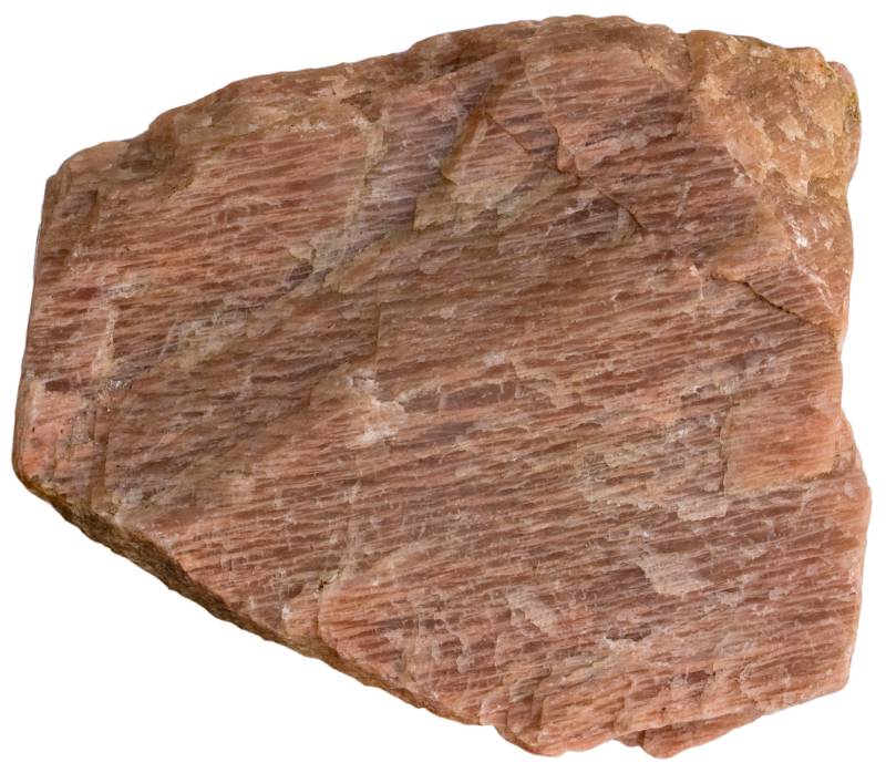
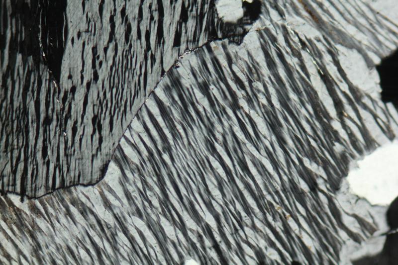
Figure 7.71 is a photo of a hand sample of perthite. This term refers to an intergrowth of K-rich and Na-rich feldspar formed by exsolution. In this specimen, the large pinkish orthoclase hand sample contains exsolution lamellae of lighter-colored albite.
Some perthitic feldspars, like the feldspar in Figure 7.71, exhibit exsolution that can be seen in hand sample. More commonly, exsolution is only visible with a microscope. For example, the thin-section view in Figure 7.72 shows microscopic perthite. The alkali-feldspar grains in this view contain about equal amounts of Na- and K-feldspar lamellae. Because the lamellae have different optical properties, they appear as alternating black and white stripes under crossed polars. Unlike exsolution in pyroxenes, exsolution in feldspars often produces wormy domains such as those seen in this photo.
| Chapter 16 Section 16.1 contains many photos of plutonic rocks in hand specimen and in thin section. If you want to know what they look like, go there. |
● Figure CreditsUncredited graphics/photos came from the authors and other primary contributors to this book. 7.0 (opening photo) Stone Mountain, ChrisYunker, Wikimedia Commons |

