KEY CONCEPTS
- Explosive eruptions can occur when viscous magma, such as rhyolite or andesite, erupts at the surface. The eruptions are powered by expanding volcanic gases, and by expanding steam if magma interacts with water.
- Explosive eruptions yield pyroclastic material consisting of ash and coarser debris thrown into the air. The material may stay in the atmosphere for years and may have profound effects on global climate.
- The most explosive eruptions produce large eruption columns that carry pyroclastic debris to high altitudes, sometimes more than 10 km above Earth’s surface.
- When it returns to Earth, pyroclastic material may harden to produce a volcanic rock or it may remain unconsolidated. If unconsolidated, it is easily eroded and may be transported to a different place and eventually become a volcanoclastic rock.
- If hot pyroclastic material settles on a volcano’s slope, the material may rush down a volcano’s side at high speeds, producing dangerous pyroclastic flows or surges.
- If pyroclastic debris and water mix, the result may be a debris flow – a wet landslide that moves downhill rapidly – or a lahar, a dangerous mudflow that move down a river valley.
- Volcanologists classify eruptions based on the volume of material they produce, which is proportional to eruption violence. From least-violent to most-violent, eruption classes are Icelandic and Hawaiian, Strombolian, Vulcanian, Peléan, Plinian, ultra-Plinian, and supervolcano eruptions.
5.1 Explosive Eruptions
▶️ Link to explosive of Krakatua Volcano in October, 2018
Explosive eruptions can occur when viscous magma, such as rhyolite or andesite, erupts at the surface. Magmas at depth in Earth contain dissolved gases but as they rise, pressure drops. The pressure decrease allows gas bubbles to form, and the bubbles expand as magma continues upwards. If the gas cannot escape easily, gas pressure builds up, especially if a bottleneck or blockage obstructs magma flow. Eventually, gas pressure becomes so high that the magma explodes out of the volcano, sending ash and coarser volcanic debris into the air. Most explosive eruptions take place at summit craters but the 1980 Mount St. Helens exploded from the side of the mountain.
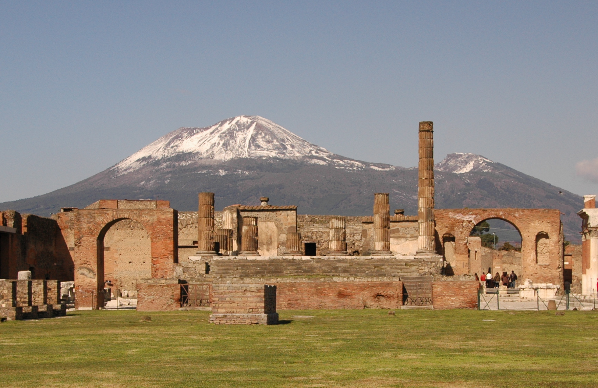
The 79 AD eruption of Mount Vesuvius that destroyed Pompeii was an explosive eruption. Pompeii and nearby Herculaneum were buried beneath 4 to 6 meters of volcanic ash, and 11,000 people died. Figure 5.1 is a photo of the ruins at Pompeii today, with Mount Vesuvius in the background. The Vesuvius eruption is often thought of as a very large event, but the modern 1991 eruption of Pinatubo in the Philippines was three or four times larger. Still earlier, the prehistoric eruptions at Yellowstone or Toba may have been 1,000 times larger than Pinatubo. Hawaiian eruptions are everyday events, but supervolcanoes the size of Yellowstone or Toba only occur on the order of every 100,000 years.
Table 5.1 lists and compares some of the more famous eruptions that geologists have studied. It includes most of the examples discussed in this book. The eruptions range from simple Hawaiian-type effusive events to huge catastrophic explosive events. The largest eruptions, at the bottom of this table, were on the order of 50,000 times more powerful than the smaller ones at the top.
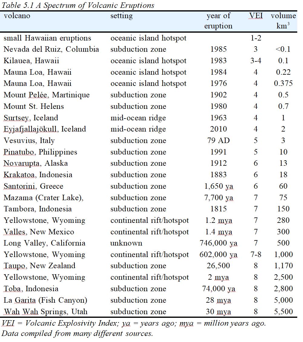 Table 5.1 is ordered from eruptions with a low volcanic explosivity index (VEI), at the top of the table, to eruptions with a high VEI, at the bottom. The VEI scale is a measure of eruption size and intensity, based primarily on the volume of material thrown into the air. Effusive eruptions, including most Hawaiian eruptions, generally have VEIs of 1 or 2. Some Hawaiian eruptions, however, are partially explosive with VEIs of 3 or 4. The VEI scale is a logarithmic scale that goes from 1 to 8. So, the eruption of Mt. Vesuvius in 79 AD (VEI = 5) was 10 times more powerful than any Hawaiian eruption (VEI = 1 to 4), and the eruption of Novarupta (VEI = 6) in 1912 was 10 times more powerful than Vesuvius.
5.2 Pyroclastic Material and Ejecta
Explosive eruptions do not produce lava but instead yield pyroclastic material, also sometimes called pyroclasts, or ejecta, consisting of ash and other debris thrown into the air. The words pyroclastic and pyroclast derive from the Greek word for fire (pyro) and an English word for fragment (clast). Pyroclastic material contains tephra, fragmental clasts derived from the exploding magma. The tephra ranges from fine ash to lapilli (little stones) to volcanic bombs and blocks that are occasionally several meters across (Table 5.2). The term bomb describes rounded clasts formed from magma ejected from a volcanic vent while molten or semi-molten. Bombs often develop “bread-crust” textures because of rapid air cooling. In contrast, blocks have an angular or blocky texture, suggesting that they were already solid at the time of eruption.
| Table 5.2 Naming tephra and rocks based on particle/rock size | ||
| clast size | clast name | rock name |
| <0.06 mm | fine ash | fine-ash tuff |
| 0.06 – 2 mm | coarse ash | coarse-ash tuff |
| 2 – 64 mm | lapilli | lapilli tuff or lapillistone |
| >64 mm | bomb (rounded) | agglomerate |
| >64 mm | block (angular) | pyroclastic breccia |
Pyroclastic material may not be uniform and commonly contains mixed clast sizes. Petrologists use specific terms to refer to clasts of different size and shape (Table 5.2). Additionally, besides tephra (ash or rock fragments created during an eruption), pyroclasts include pieces of older volcanic rocks from the same volcano or xenoliths derived from country rocks beneath the volcano. So, pyroclastic material is quite variable and, consequently, so are pyroclastic rocks. Table 5.2 includes the most commonly used rock names.
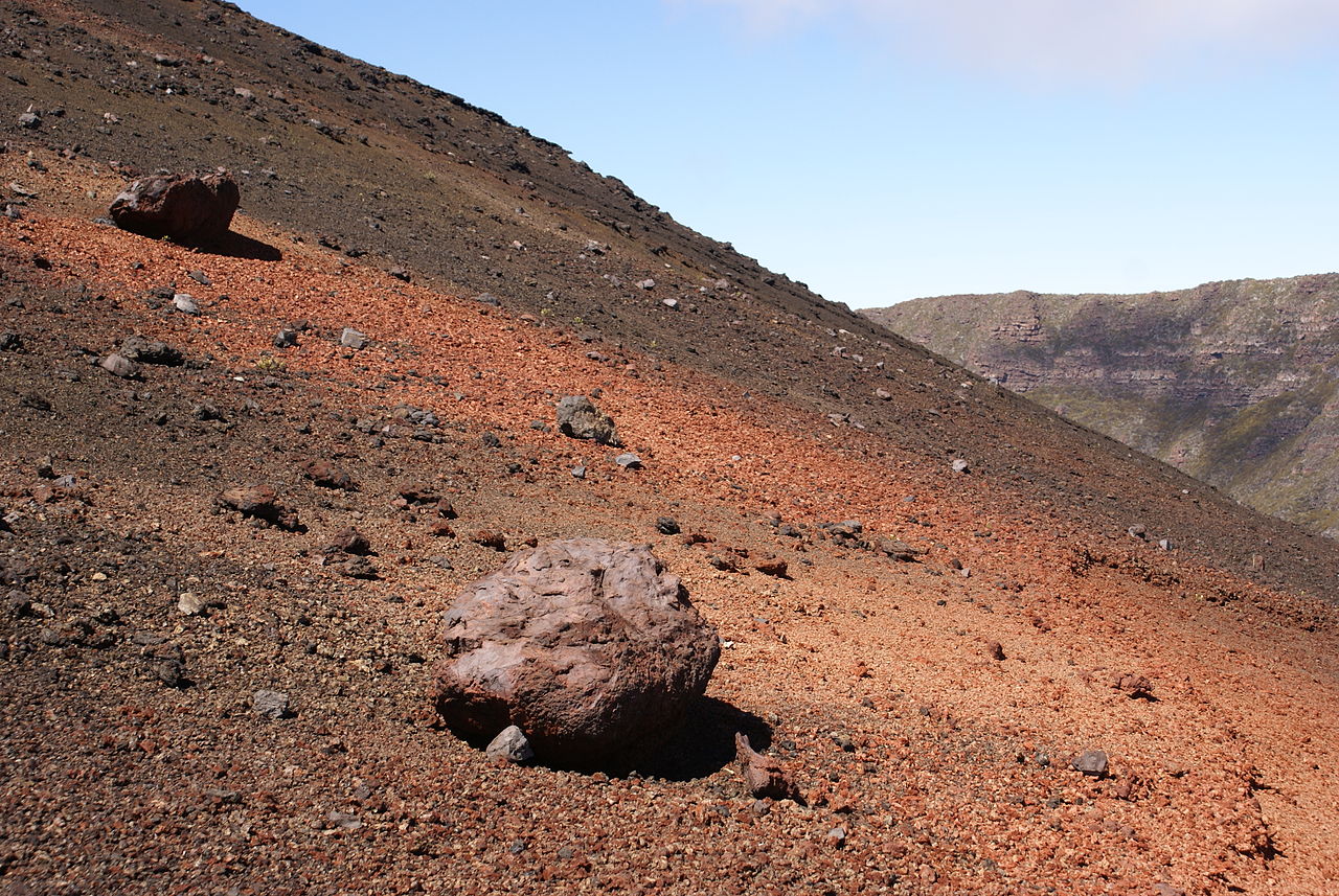
Figures 5.2, 5.3, and 5.4 are examples of ash, lapilli, and bombs from Redoubt Volcano (Aleutian Islands), Pico do Fogo (Cape Verde Islands), and Réunion Island (Indian Ocean). Tephra of all sizes may consist of any combination of glass and mineral matter.
|
|
|
|

Once it falls to Earth, water, wind, or gravity may move unconsolidated pyroclastic material to a different place. This produces a reworked deposit – a sedimentary deposit that has a volcanic origin but retains little volcanic character. We use the general adjectives pyroclastic or volcanoclastic for both in situ and transported material. The two terms are often used interchangeably, but in strictest sense, pyroclasts are volcanic material ejected from a volcanic vent. Volcanoclastic rocks may consist of pyroclasts and also of other kinds of materials including rock fragments of various origins and other erosional debris.
Pyroclastic and volcanoclastic material may remain as unconsolidated debris, or may become lithified to produce a volcanic rock. Lithification can occur quickly or may take a long time. We use the noun tuff and adjective tuffaceous in a generic sense to refer to any lithified volcanoclastic rock. Tuffs typically contain volcanic ash and glass, mineral crystals, and sometimes rock fragments.

If a volcanoclastic rock contains clasts of uniform size, we name it using the names listed in the right-hand column of Table 5.2. However, many volcanoclastic rocks contain a mix of clast sizes. The International Union of Geological Sciences (IUGS) developed a standard classification system, depicted in Figure 5.5, that considers variable clast size. The system is based on the volumes of clasts of different sizes that a rock contains. In the IUGS system, the noun tuff refers only to rocks containing mostly ash.
We can make the IUGS rock names more specific by using modifiers that describe the nature of the clasts or the composition of the rock (Table 5.3). A vitric tuff, for example, is a tuff dominated by glassy clasts. A basaltic tuff-breccia is one having the overall composition of a basalt. We also can distinguish between tuffs and welded tuffs. Welded tuffs are those that lithified (welded together) immediately during cooling after material settled to the ground.
| Table 5.3 Naming tephra and rocks based on particle/rock size | |
| terms describing the nature of clasts | terms describing composition |
| vitric: composed of glassy clasts | rhyolitic: having the composition of rhyolite |
| crystalline: composed of crystalline clasts | dacitic: having the composition of dacite |
| lithic: composed of rock fragments | basaltic: having the composition of basalt |
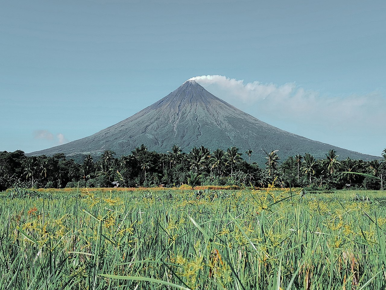
Some explosive volcanoes produce both pyroclastic material and lava flows. The magmas of explosive volcanoes generally have silicic to intermediate compositions and, consequently, flows are quite viscous. So the lavas are sticky and do not flow downhill easily or travel long distances. This can produce a classic volcano-shaped mountain – a steep sided conical mountain with a crater on top, called a stratovolcano, also called a composite volcano. These volcanoes may comprise layers of pyroclastic rocks alternating with lava. The Philippines’ Mayon Volcano is a classic example (Figure 5.6).
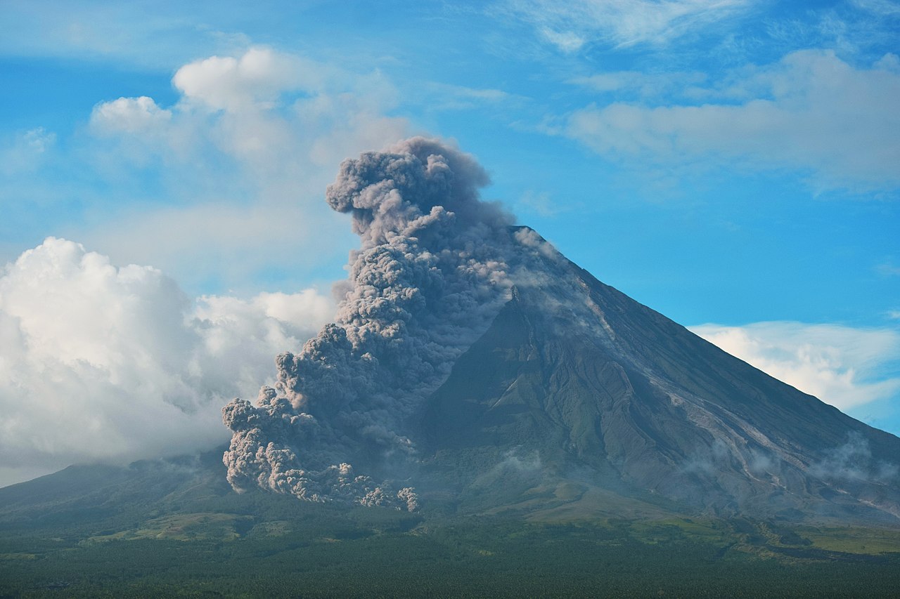
Figure 5.6 is a view of Mayon Volcano at a quiet time. But Mayon is a very active volcano and its eruptions often involve huge volumes of ejecta consisting of ash and other material thrown into the air. Figure 5.7 shows a violent Mayon eruption in 1981. Some ejecta settled on the flanks of the volcano, producing flows of hot gas and ash that travel down the volcano’s flanks, as seen here. This photo was taken during Mayon’s 1981 eruption, but the most destructive eruption was in 1814 when tephra completely covered the nearby town of Cagsawa, causing several thousand deaths. The total ash deposits were nearly 10 meters deep in some places, and some volcanologists believe that airborne ash from the eruption contributed to the global Year Without Summer created by a globe-circulating ash cloud after Tambora erupted of 1815.
5.3 Eruption Columns
In contrast with effusive eruptions, explosive eruptions produce large eruption columns that carry pyroclastic debris up to high altitudes, occasionally reaching the stratosphere 10-15 kilometers above Earth’s surface. The size of an eruption column varies, depending on the volume of material involved and the violence of the eruption.
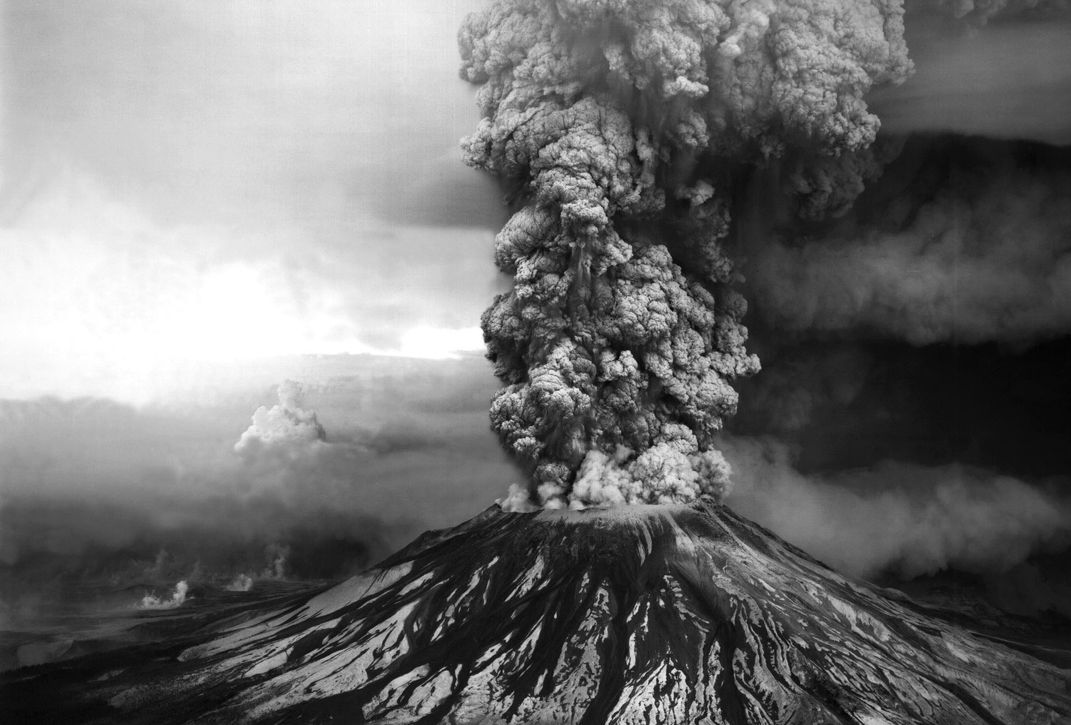
Mount St. Helens, in Washington, erupted in spring, 1980. For two months it produce much ash and created a large eruption column (Figure 5.8). Winds dispersed ash and other fine material across much of North America. Overall, the 1980 eruption was not particularly large, but it was the only major eruption in the continental United States to occur in nearly 40 years. On May 18, 1980, at about 8:30 a.m., the volcano exploded. The event destroyed many homes and much infrastructure, and it killed 57 people (Box 5.1).
● Box 5.1 The 1980 Mt. St. Helens EruptionBeginning in late March, 1980, Mt. St. Helens came alive after a long time of no volcanic activity. Earthquakes, steam venting, and some relatively small explosive eruptions and pyroclastic flows occurred over about two months. During this time, magma accumulated and the mountain began to bulge on its north side. At a little after 8:30 am on May 18, an earthquake triggered a major landslide (the largest landslide ever known to occur in recorded history) on the volcano’s north slope. High-pressure gas, steam, magma, and solid rock debris exploded outward. The eruption had a VEI value of 5, and was the largest eruption in the lower 48 states since a 1915 eruption of Lassen Peak in California. David A. Johnston, a USGS volcanologist, was monitoring the volcano from 10 km away when the major eruption occurred. He was the first to report the eruption, transmitting “Vancouver! Vancouver! This is it!” on his radio before he was engulfed by the fast-moving volcanic cloud a minute or two later. Johnston’s body was never found, but state highway workers discovered remains of his USGS trailer, including a propane tank, electrical wiring, insulation, and some siding, in 1993. 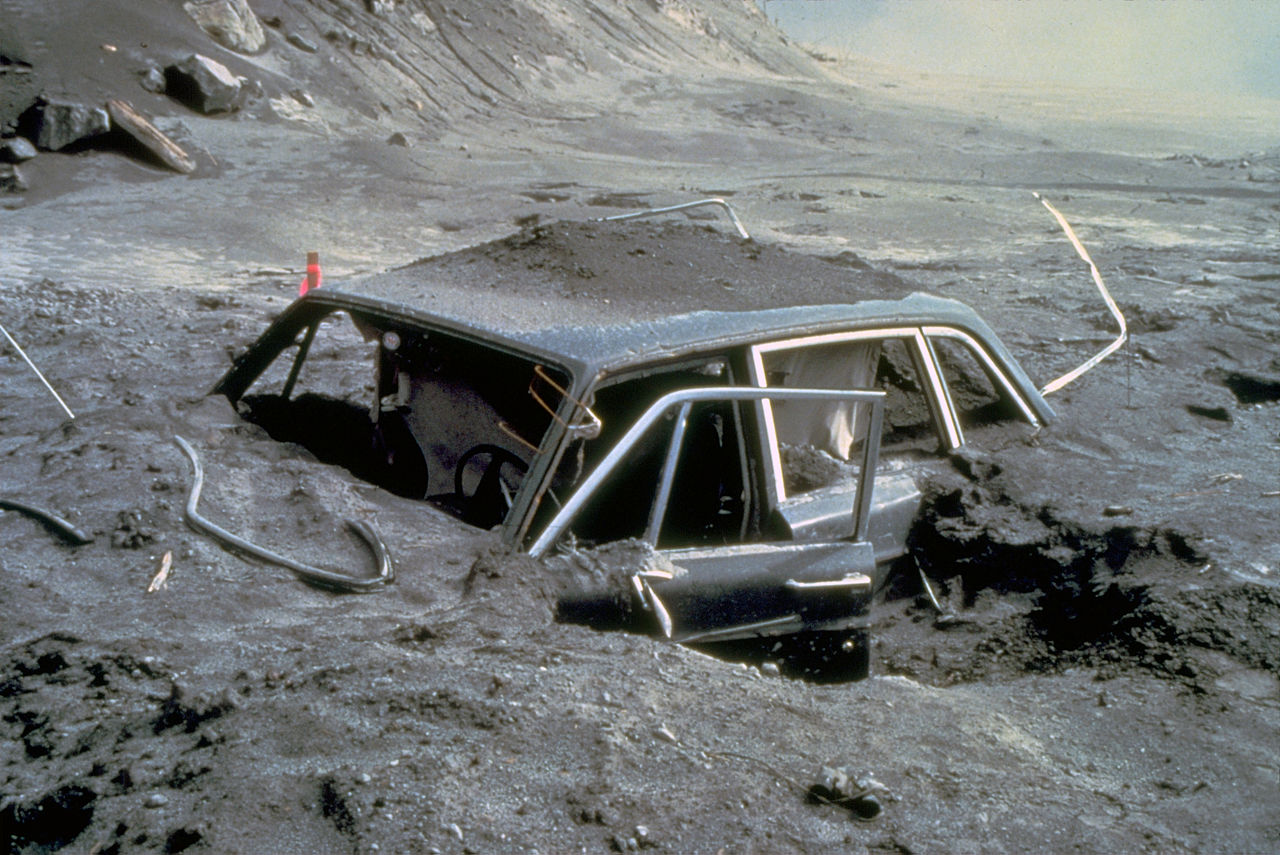 Besides Johnston, 56 others were killed, most by asphyxiation due to inhaling ash and hot gases. The dead included an innkeeper who refused to leave his lodge at the base of the mountain and was buried by the landslide produced by the explosion, and two photographers. One died in the car seen in Figure 5.9. The car was in a campground 15 km from the volcano. The other victims were mostly hikers and campers who wanted to be near the volcano to watch it erupt. None were in the zone closed to all visitors but all were too close. Complete devastation extended 17 km from the volcano, and killer ash and gas clouds went twice that far. Although Johnston and others warned of such possibilities, Washington state officials lacked the political courage to keep all visitors a safe distance away. They argued afterwards that there was no way to know that devastation would extend so far from the volcano. |
Explosive volcanoes may erupt many times. For example, Mayon Volcano, discussed earlier in this chapter, has exploded more than 50 times in the past 400 years. Most volcanoes, however, do not have as long a history of activity, and may erupt for weeks or months and then become dormant. Figure 5.10 shows an eruption of Mount Pinatubo, in the Philippines, in June 1991. Pinatubo exploded often over an eight-day period. The volcano has erupted many times in the past, but the 1991 eruptions were the only ones in modern history.
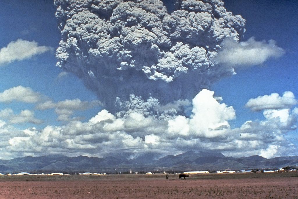
The photo in Figure 5.10 was taken three days before the Pinatubo’s last major explosion. The large cloud of volcanic ash and gas above the volcano is impressive, and the eruption column rose more than 40 km and reached the stratosphere. In total, Pinatubo produced more than ten times the amount of pyroclastic material produced by Mount St. Helens.
Material that rises in an eruption column eventually returns to Earth. More than 350 people died during Pinatubo’s 1991 eruptions – most from collapsing roofs due to ashfall. Disease in evacuation camps and mud flows caused additional deaths, bringing the total death toll to 722 people.
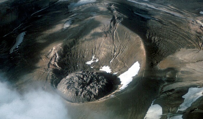
Pinatubo’s 1991 eruption was large, but an eruption of Novarupta, in a remote part of Alaska’s Aleutian Islands, was larger. When this volcano erupted for three days in June 1912, it was the largest eruption by volume in the 20th century. Novarupta still has signs of activity today. Three explosive episodes produced 20 times more material than the 1980 eruption of Mount St. Helens, and 30% more material than Pinatubo. The eruption column rose to 50 km, and Novarupta ash traveled around the globe for more than three years. The eruption ended when a lava dome, similar to the one in Figure 5.11, formed in the summit crater and plugged the vent. The dome in this 1987 photo is nearly 90 meters high and 360 meters wide. It is larger than the dome in the crater at the top of Mt. St. Helens in Washington but is smaller than Wilson Butte in California (see Figure 4.62).
5.3.1 Airfalls
Pyroclastic material thrown into the air during an eruption is quite variable in composition and contains particles of many grain sizes. When the material falls back to Earth, we call it an airfall, or simply a fall. Most airfalls have a silicic or perhaps an intermediate composition. They may contain volcanic ash, pumice, or rock fragments. Although much less common, mafic magmas may produce pyroclastics, too, most notably when mafic magmas interact with water, creating steam explosions that blast material into the air.
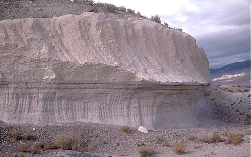
Although pyroclasts range from fine ash to quite large fragments (sometimes as large as footballs or basketballs, or even larger), the largest sizes fall to Earth quickly and collect close to the source volcano. Finer-grained material, however, may spread out and create airfalls that cover large regions, like the deposits that characterized the Tambora and Toba eruptions that affected life in profound ways. Figure 5.12 is a photo of thick layers of the Fish Canyon Tuff that formed about 28 million years ago. The tuff consists of ash from an eruption associated with La Garita Caldera in southwestern Colorado. The eruption that produced this tuff was one of the largest eruptions on record, producing 5,000 km3 of ejecta. Figure 4.4 is another view of this tuff.
Volcanic ash, when it settles, can be solid and dense, or very light (tuffaceous), depending on how much air is between ash fragments. It may remain as tephra (unconsolidated ash), but often erupted silicic and intermediate magmas are still molten or partially molten when they land. If so, they may become welded during cooling, creating a pyroclastic rock. Ashfalls and other airfall deposits are often well-sorted. Layers have a generally uniform grain size because different sized materials settle at different rates and in different places. The finest material may remain suspended for days or much longer. It may travel around the globe causing a volcanic winter like the Year Without Summer created by Tambora in 1815, and affecting climate for years. Figure 5.13 is an example of an airfall tuff that contains mostly pumice.
5.3.2 Flows and Surges
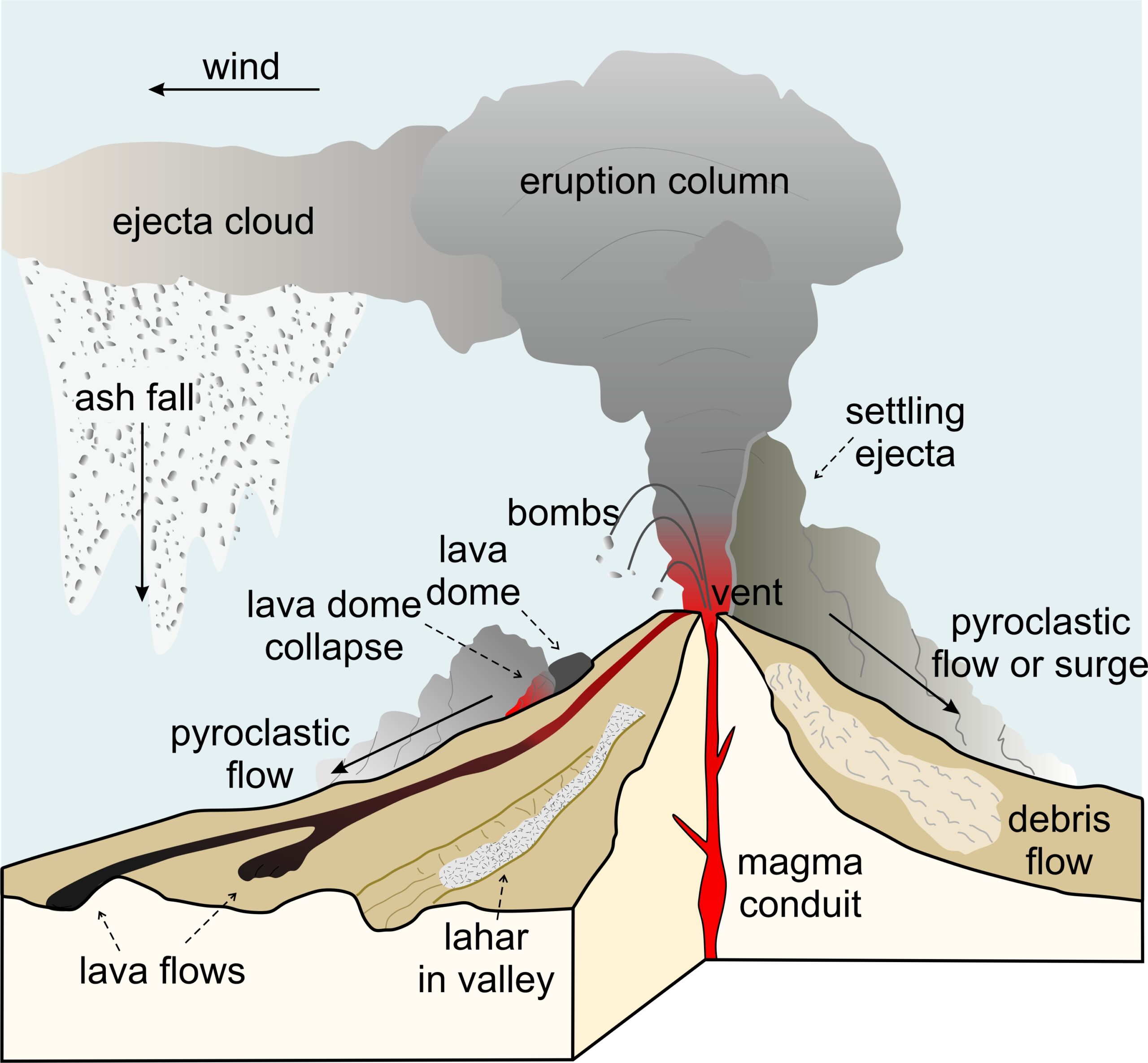
After losing its momentum, gravity can overcome a rising eruption column and large amounts of pyroclastic material may fall to Earth rapidly (Figure 5.14). Often, the hot pyroclastic material settles directly on slopes of the volcano that created it. Clouds of hot gas (up to 1,000 ̊C), ash, and rock can rush down a volcano’s side (at up to 700 kilometers/hour) in a pyroclastic density current (Figure 5.14). These current may be of two types, pyroclastic flows or pyroclastic surges, but the distinction between the two is a hazy one based on the ratio of gaseous to solid material. Flows contain more solids and, due to their density, often follow and are confined to river valleys. Surges, however, are more gaseous than flows and, consequently, less dense. They rise to cross ridges and hills. Flows and surges are some of the deadliest volcanic events, but fortunately today, we usually have ample warning before they occur.

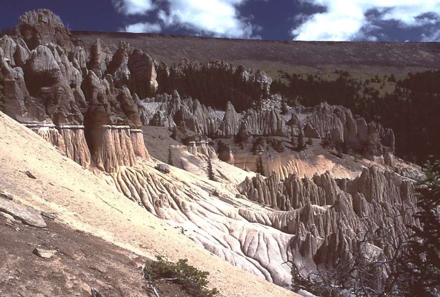
The Bandalier Tuff (Figure 5.15), in Bandalier National Monument, New Mexico, contains the remains of homes carved into the tuff by Ancestral Puebloans more than 11,000 years ago. The soft tuff, made from glassy silicic volcanic ash, was perfect for carving homes with primitive tools. The ash in this photo was deposited as ashflows during eruptions associated with the nearby Valles Caldera 1.14 million years ago. Flows, with temperatures up to 700 oC, moved faster than 100 km/hr and traveled more than 25-35 km from the eruption site. The tuff is more than 300 meters thick in places, and is especially thick where it filled valleys and canyons. Ashflows are relatively local, but airfall deposits associated with the Valles Caldera have been found more than 1,000 km from their source. See Figure 4.29 for another view of this tuff.

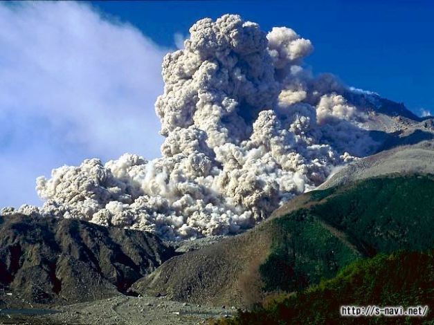
The photo of Mayon Volcano in Figure 5.7 shows a large pyroclastic flow that occurred in 2001. Figure 5.16 is a photo of a different pyroclastic flow. The photo is an aerial view Sarychev Volcano in the Kuril Islands (Russia’s equivalent of the Aleutian Islands) with a huge eruption column and a flow running down the volcano’s side. This volcano has erupted more than 15 times during the past 200 years, and most eruptions that have been witnessed involved pyroclastic flows.

Upon settling and cooling, pyroclastic material from both flows and surges typically lithifies to produce tuffs called ash-flow tuffs, also called ignimbrites. In contrast with airfall deposits, ignimbrites may be a jumble of poorly sorted material of many sizes, including pumice fragments, rock fragments of other sorts, ash, and mineral grains. The rock seen in Figure 5.17, from the Sierra Madre Occidental volcanic field in Mexico, is an ignimbrite containing consolidated volcanic ash with coarser grained rock fragments of variable composition. Most of the fragments are pumice squashed into flattened shapes called fiamme. The fiamme weathered and eroded, in places leaving long skinny holes. Ash-flow tuffs range in composition, but most are silicic to intermediate. Rhyolitic (silicic) ash-flow tuffs are one of the most common volcanic rocks in continental regions.
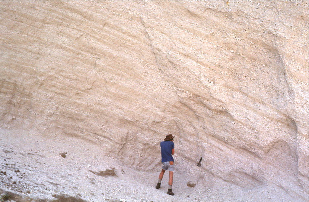
Different eruptions of the same volcano, and different times during a single eruption, may produce different kinds of deposits. For example, Figure 5.18 shows a 10-meter tall outcrop of Bishop Tuff, near Mammoth Lakes, California. Airfalls produced the typical horizontally layered pumice deposits in the bottom part of this outcrop. The top massive part of the outcrop contains ash-flow tuff.
5.3.3 Nuée Ardentes
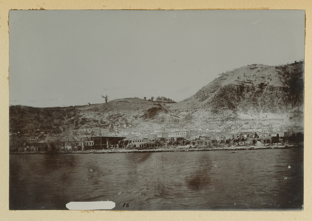
Lava domes form when silicic to intermediate lava piles up over a vent because it is too viscous to flow away. Typically this occurs in craters or near the tops of steep sided volcanic mountains. Sometimes, as depicted in Figure 5.14, the domes become unstable and collapse to flow down a volcano’s side. The flows move rapidly, up to 80 kilometers/hour, and may travel as far as 10 or 15 kilometers from their source. In 1902, a dome on Mount Pelée, on the Caribbean Island of Martinique, collapsed and created a pyroclastic flow that engulfed the town of St. Pierre. The infamous flow killed all except two of the town’s estimated 29,000 residents. Figure 5.19 is a photo of St. Pierre in the aftermath of the eruption. The name nuée ardente (French for “glowing cloud“) is from the 1902 Pelée eruption because, in the dark, the volcano’s flows glowed red.
Even experienced volcanologists can misjudge a volcano’s behavior. In the summer of 1991, a dome at the summit of Mount Unzen, Japan, collapsed. It created a flow, seen in Figure 5.20, that killed 43 people, including volcano experts and journalists who thought they were in a safe spot.
▶️ Link to some good film footage of pyroclastic flows
5.3.4 Debris Flows and Lahars
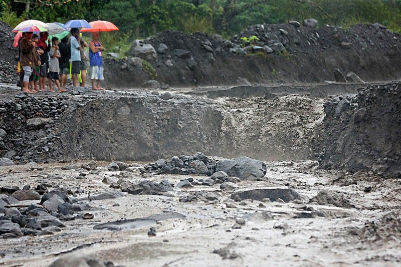
If pyroclastic debris and water mix to produce a fluid mud, the result may be a debris flow – a wet landslide that moves downhill rapidly (Figure 5.14). If flowing mud becomes confined in a valley, it can produce a lahar – a mudflow that moves like a river. Figure 5.21 shows a lahar near Mayon Volcano in 2018.
▶️Link to video of lahar caused by Merapi Volcano (Indonesia) in 2015.
Lahars range from being small and inconsequential to being large and disastrous. The largest lahars may be hundreds of meters wide, tens of meters thick, and travel at speeds greater than 200 kilometers per hour. They can travel hundreds of kilometers down valleys and destroy everything in their path. In 1985 Nevado del Ruiz, a volcano in Columbia, erupted. Hot pyroclastic material melted snow on the volcano’s summit, creating a lahar. The mudflow traveled nearly 50 kilometers down a river valley and buried the city of Armero beneath 5 meters of mud and debris, killing 23,000 people.
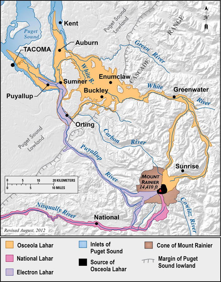
Washington’s Mount Rainier is considered dangerous because of the risk of lahars. Many towns near Mount Rainier are on lahar deposits that are only a few hundred or a thousand years old. So, we can expect lahars to reach them in the future. An eruption is not required to produce a lahar. Heating at the summit could catastrophically melt snow and produce lahars from meltwater mixing with pyroclastics from earlier eruptions. Aware of this risk, the United Stated Geological Survey has installed lahar monitors and warning systems so that people may escape if lahars pose a threat. Figure 5.22 shows some of the paths of past lahars originating from Mt. Rainier. Some major towns and cities are sitting in harm’s way today.
5.4 Hydrovolcanic Eruptions
5.4.1 Phreatic Eruptions
Expanding magmatic gases power most explosive eruptions, but some explosive events are partially or entirely powered by expanding steam created when magma interacts with groundwater or surface water. These are phreatic eruptions, a type of hydrovolcanic eruption, involving steam-blast explosions powerful enough to fracture and disperse pieces of surrounding rock. Such eruptions produce columns composed of rock fragments and steam, commonly with little ash or other tephra.
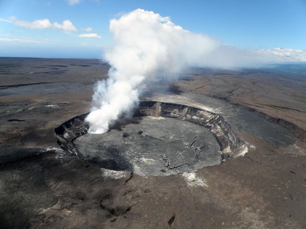
Much of the 1980 volcanic activity of Mt. St. Helens involved phreatic eruptions. And Kilauea Volcano, in Hawaii, known today for its typical effusive eruptions, has been more violent in the past. On May 10, 1924, a huge phreatic eruption began at Kilauea’s summit and lasted nearly three weeks. Eruption columns rose to altitudes of more than 1,830 meters, and huge rocks – up to 8 tons – were thrown more than 800 meters from the crater. The eruption created the large Halema’uma’u crater, 950 meters across and 400 meters deep. Figure 5.23 is the crater in 2009. A large steam plume is emanating from hot lava reaching the surface.
5.4.2 Phreatomagmatic Eruptions
If an eruption is partly powered by dissolved gases in magma, and partly by steam, we call it a phreatomagmatic eruption. The 1991 eruption of Pinatubo was, in large part, phreatomagmatic. This, in part, explains why the eruption was so explosive. Figure 5.24a is a photo of a phreatomagmatic eruption 32 km south of Iceland in 1963. The first signs of the eruption were seen by people on fishing boats in the region – dark smoke rising from ocean waters. Continuing phreatomagmatic eruptions created a new island after four years of activity, and Surtsey Island was born. Today, the island is a nature preserve, only visited by scientists studying succession, the colonization of the island by different plant and animal species over time.

More recently, on November 20, 2013, a series of spectacular phreatomagmatic eruptions created the Japanese island of Nishinoshima. The explosions lasted many weeks. Figure 5.24b is a view of the island during its early days. This infrared image shows lava (red) at the summit, and flows that erupted on the bottom edge of the island. During the formation of this island, lava, ash, and rock fragments, propelled by steam derived from ocean water, were ejected into the air. The debris settled and accumulated to create an island where none existed previously.
Hydrovolcanic eruptions can produce eruption columns that are mixtures of pyroclasts and water. Due to their high density, the columns often collapse on themselves to produce surges, called base surges, similar to, but often more dynamic than surges produced by a collapsing eruption column associated with a normal “dry” volcano. In such a surge, a fast-moving cloud of steam and debris hugs the ground and spreads outward from the center, traveling as much as a kilometer from the eruption site. The surges have geometry and motion similar to what occurs during nuclear explosions – clouds rolling outwards in a big ring. Figure 5.25 below contains photos of the recent eruption of Taal Volcano in the Phillipines and the base surge that it created.

5.4.3 Maars
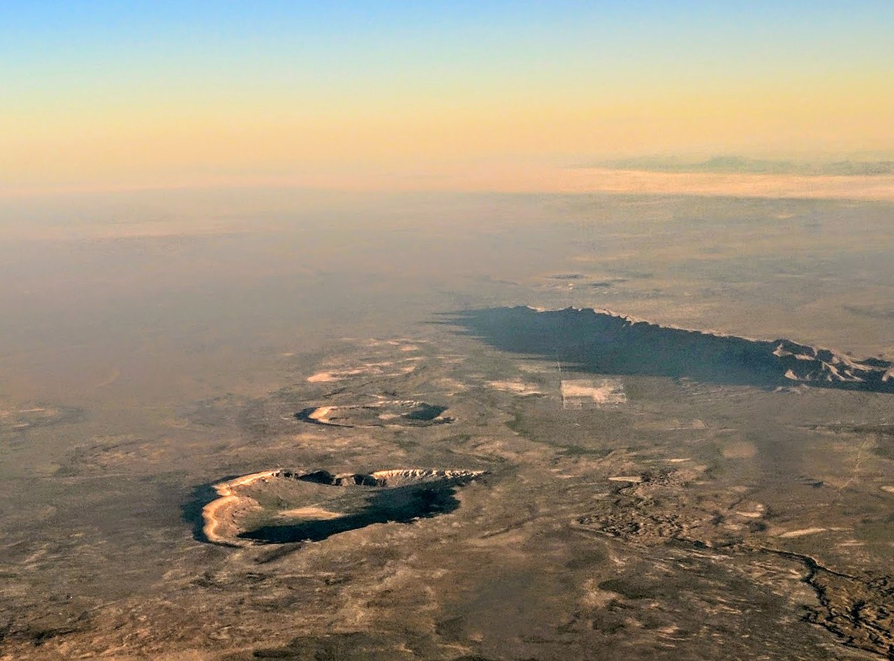
On continents, hydrovolcanic eruptions may produce shallow craters called maars, often surrounded by unconsolidated deposits called tuff rings. Maars form when an explosive eruption creates a broad flat-bottomed hole in the ground, and tuff rings – a little like dunes – contain material ejected during the explosion. Figure 5.26 shows two maars with tuff rings in the Potrillo Volcanic Field of New Mexico. The largest depression is Kilbourne Hole, and the smaller one behind it is Hunt’s Hole. The tuff rings appear as narrow ridges that surround the shallow craters. Maars range in size from 60 to 8,000 meters in diameter and 10 to 200 meters in depth. Box 5.2 describes Kilbourne Hole, a small maar, in more detail.
● Box 5.2 Kilbourne Hole National LandmarkFigure 5.25 is a view of Kilbourne Hole, a U.S. National Landmark, seen from the north. The hole is a maar volcano crater about 50 km west of El Paso, Texas. The crater is elliptical, close to 3 km in longest dimension, and 90 m deep at it deepest spot. The eruption that created Kilbourne Hole blasted a shallow depression in loose sediments and a thin basalt flow. A 10-14 m tall basalt cliff surrounds the crater on most sides. The eastern and northern edges of the crater have a slight rim composed of pyroclastic surge deposits on top of the basalt. 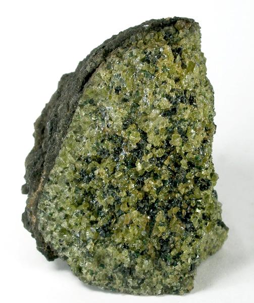 Kilbourne Hole is exceptional and famous with geologists because of the large number of xenoliths in the loose crater deposits. The xenolith seen in Figure 5.27 is a typical example. The xenoliths are fragments of Earth’s lower crust and upper mantle that were carried to the surface by erupting magma. Geologists have few mantle samples to study – because mining and drilling do not go deep enough – so xenoliths such as those from Kilbourne Hole receive lots of attention. Most of the Kilbourne mantle samples are harzburgites or lherzolites – kinds of ultramafic rocks composed primarily of olivine and orthopyroxene, with lesser amounts of clinopyroxene. Some samples are pyroxenites containing orthopyroxene and clinopyroxene, and lacking olivine. In Figure 5.27, the dominant light green mineral is olivine, the dark green-brown mineral is orthopyroxene, and small crystals of emerald-green clinopyroxene are present but difficult to pick out. The xenolith is encased in a thin layer of dark gray basalt on its left side. |
5.5 Different Types of Eruptions
Before concluding this discussion of explosive volcanoes, it is worth reviewing some of the different kinds of eruptions. Different volcanoes erupt in different ways, eruptions vary greatly in character, and some are a hundred, or even a million, times more violent than others. Volcanologists often classify eruptions based on their style of eruption, which correlates very well with the volume of material they expel, their eruption column height, and explosivity (VEI). Figure 5.28 depicts these relationships. VEI increases from left to right, and so does the volume of erupted material, depicted by the red spheres. Eruption column height, too, increases from left to right, with the largest eruptions sending material more than 25 km up into the atmosphere.
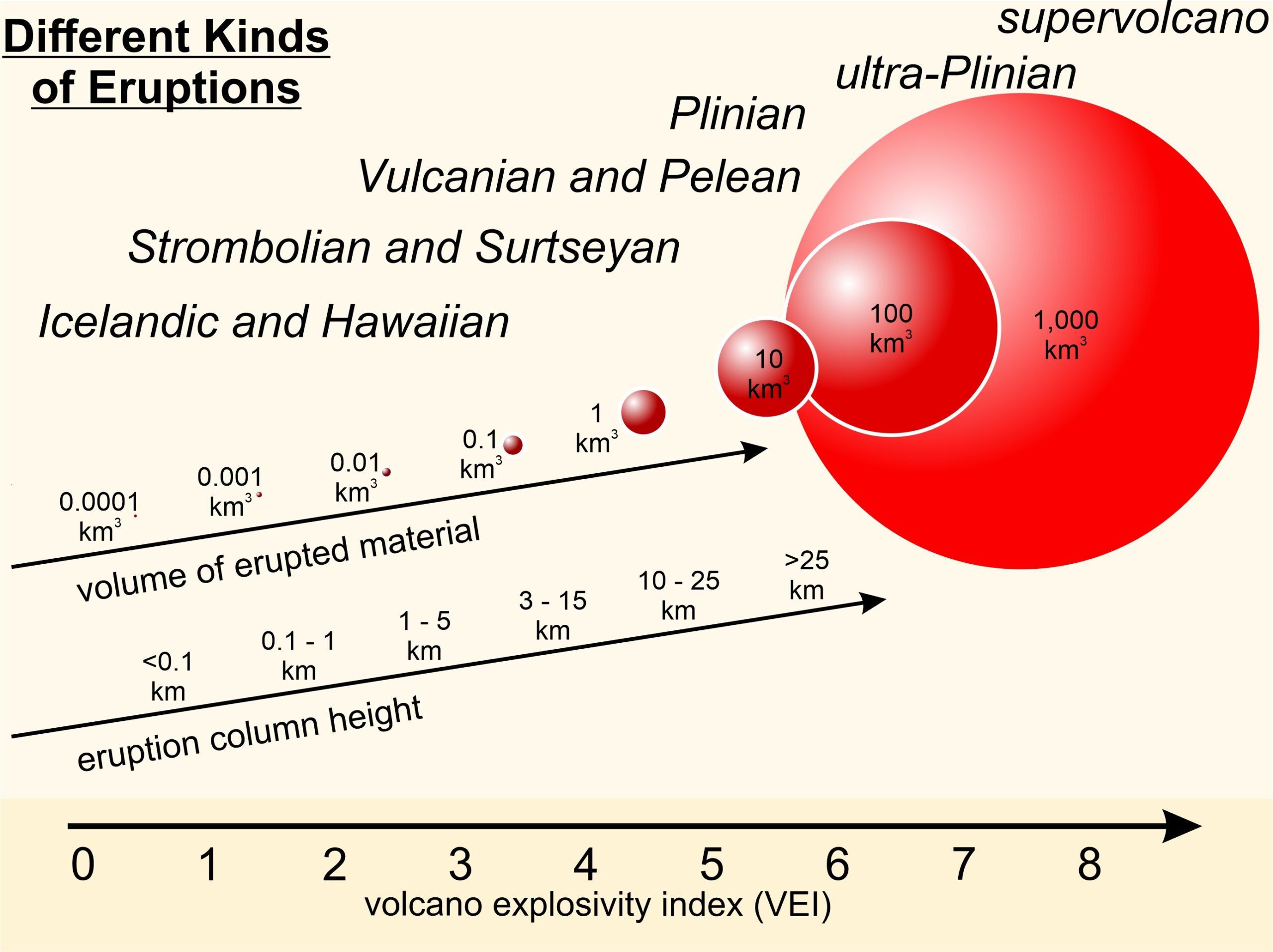
The least violent eruptions, Icelandic eruptions and Hawaiian eruptions, are effusive. They involve small amounts of magma and rarely create eruption columns. Icelandic eruptions are mainly vent eruptions whereas Hawaiian eruptions are often associated with large volcanoes.
As seen in Figure 5.28, explosive volcanoes, in order of increasing VEI and size, create Strombolian, Vulcanian, Peléan, Plinian, ultra-Plinian, and supervolcano eruptions. Most of these different kinds of eruptions are named after classic volcanoes. We discussed an additional type, Surtseyan eruptions, above. Surtseyan eruptions are phreatomagmatic eruptions with explosiveness about the same as Strombolian volcanoes, but are not included in this figure because of their special mode of origin.
Volcanoes with low VEI are commonplace today, but those with high VEI (ultra-Plinian and supervolcanoes) occur rarely. Only four eruptions with VEI of 7, and none with VEI of 8, have occurred during the past 10,000 years. Supervolcanoes, Plinian eruptions that produce more than 1,000 cubic kilometers of pyroclastic material, are exceptionally rare.
5.5.1 Icelandic and Hawaiian Eruptions
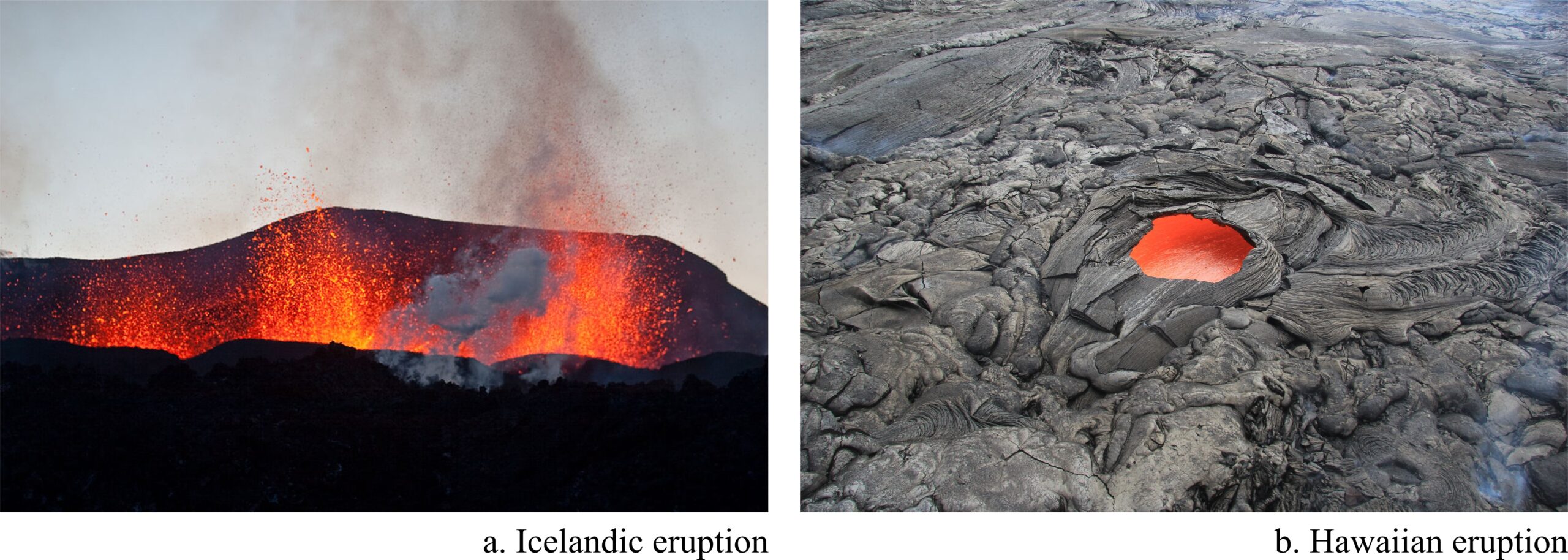
Figure 5.29a is a photo of a typical Icelandic fissure eruption with lava fountains. Figure 5.29b is a Hawaiian lava flow containing a skylight. Both kinds of eruptions involve basaltic magma and produce basalt flows. Hawaiian eruptions may also create shield volcanoes.
5.5.2 Strombolian Eruptions
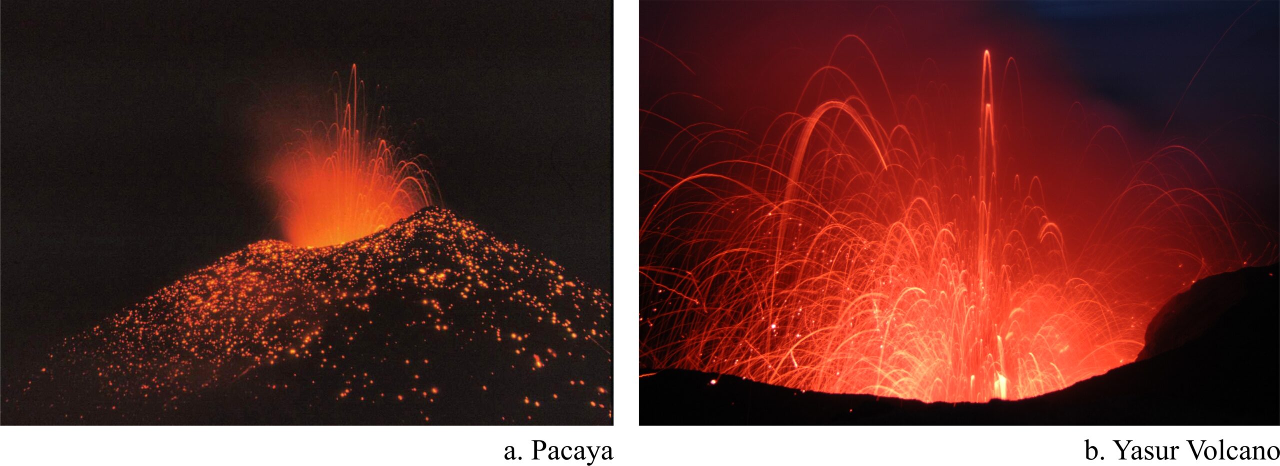
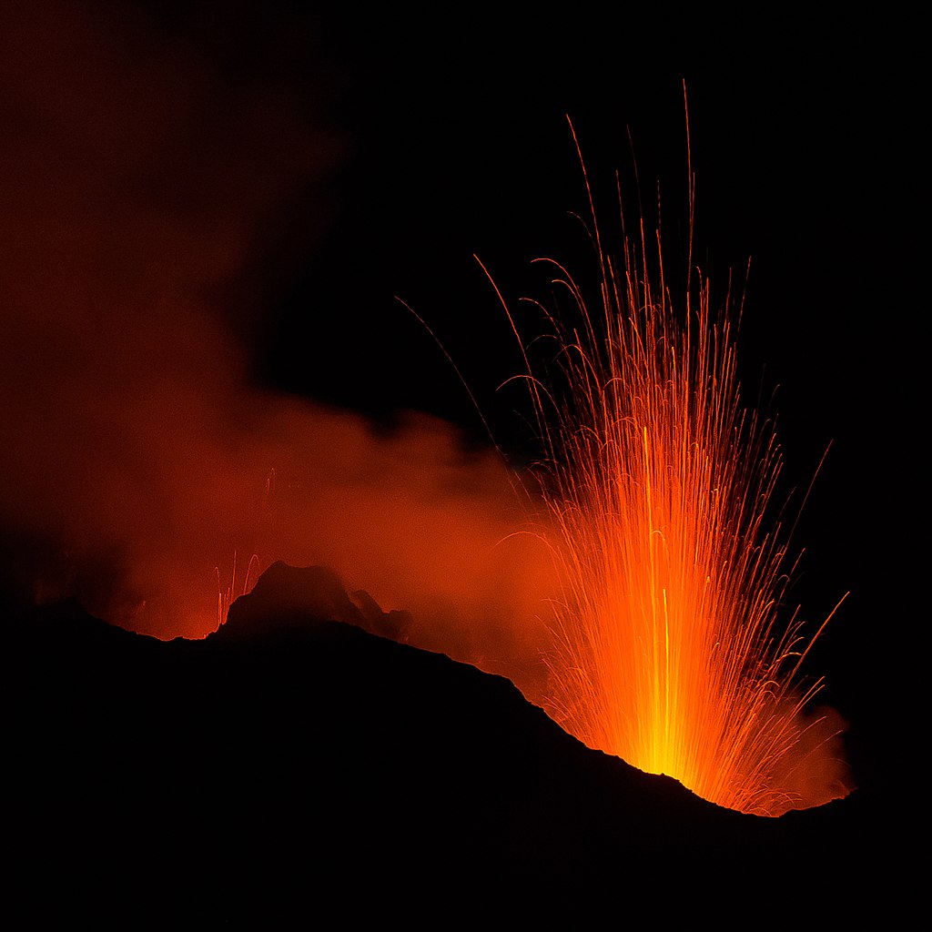
Strombolian eruptions, named after the island volcano Stromboli, near Sicily, are characterized by basaltic eruptions that toss incandescent pyroclasts of various sizes as high as several hundred meters, sometimes creating incandescent “rooster-tails.” These eruptions are shorter lived and involve fewer flows than Hawaiian eruptions. Significant eruption columns do not form as they do for larger eruptions. Strombolian eruptions often create cinder cones, and, sometimes, small to large composite volcanoes composed of solidified lavas, ash, pumice, and other tephra. Figure 5.30 contains photos of two Strombolian eruptions: Pacaya Volcano in Guatemala and Yasur Volcano, in Vanuatu, 1,600 kilometers northeast of Australia. Both photos show the rooster tails of bright pyroclastics that characterize Strombolian eruptions. The opening photo in this Chapter is another example, and Figure 4.6 shows Stromboli erupting in 2015.
5.5.3 Vulcanian Eruptions
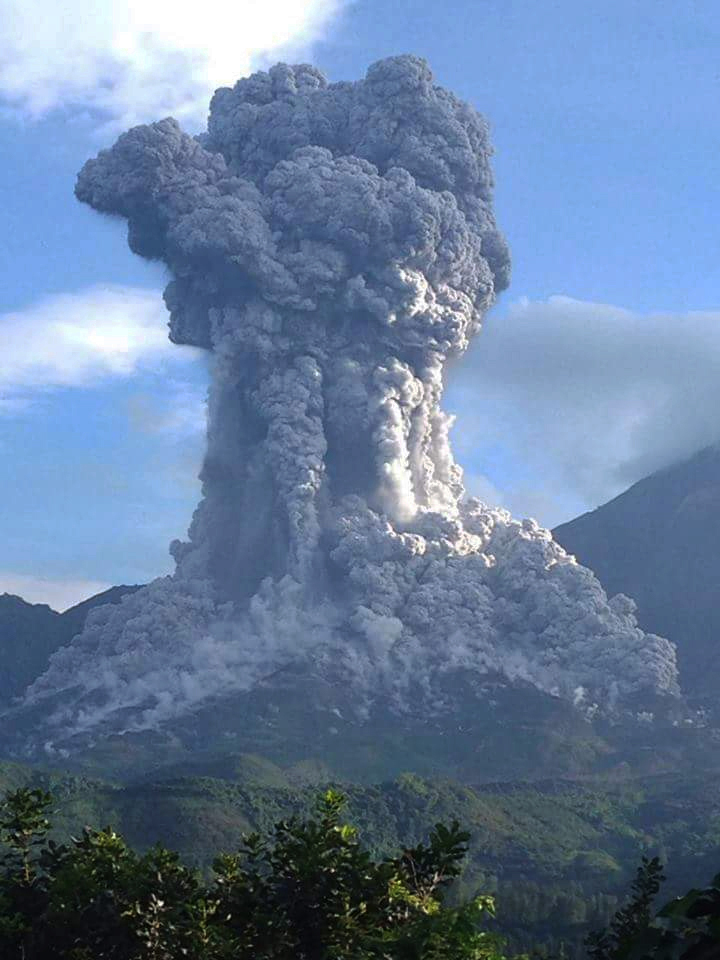
Figure 5.31 shows a 2016 eruption of Guatemala’s Santiaguito Volcano. This type of eruption is a vulcanian eruption, named after a small volcanic island about 25 kilometers north of Sicily. Santiaguito and nearby Vulcano are both active volcanos, but Vulcano has not erupted in more than 125 years.
Vulcanian eruptions are generally more explosive than Strombolian ones but erupt intermittently and produce only small volumes of magma. They may create moderate-sized eruption columns that rise as far as 10-20 kilometers into the atmosphere. Large blocks and bombs are typical eruption products. Additionally, collapsing pyroclastic columns or collapsing domes can create pyroclastic flows (like the ones seen in this photo, Figure 5.30) that travel downhill at speeds as fast as 150 kilometers per hour.
5.5.4 Peléan Eruptions
Peléan eruptions, named after Mt. Pelée on the island of Martinique in the Caribbean, are similar to Vulcanian eruptions in many ways. In contrast with Vulcanian eruptions, however, Peléan eruptions often occur as a single large explosion. Nuée ardentes, the pyroclastic flows created by collapsing lava domes, are an essential part of the definition of a Peléan eruption. An earlier part of this chapter described the destruction of St. Pierre, Martinique, by a nuée ardente in 1902. There have been other examples since then, including the 1948-1951 eruption of Hibok-Hibok (Camiguin Islands, Philippines), the 1951 eruption of Mt. Lamington (Papua New Guinea), the 1968 eruption of Mayon (Luzon Island, Philippines), and the 2021 eruption of La Soufrière (Saint Vincent Island in the Caribbean).
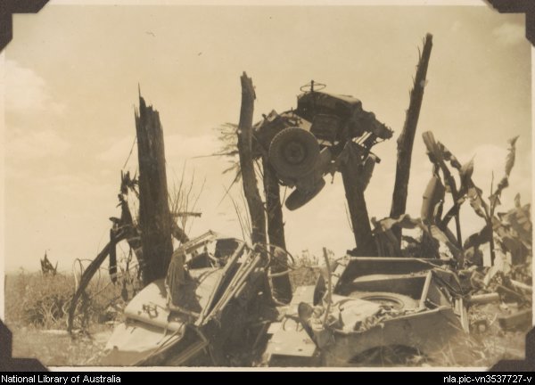
Mt. Lamington, an andesitic volcano in Papua New Guinea, began erupting in early January, 1951. Three days later, domes at the summit collapsed and the volcano produced a pyroclastic flow that caused much destruction and many deaths to 14 km away from the eruption site. More than 3,000 people died. The photo in Figure 5.32 is a photo of a jeep left in a tree after eruptions ceased.
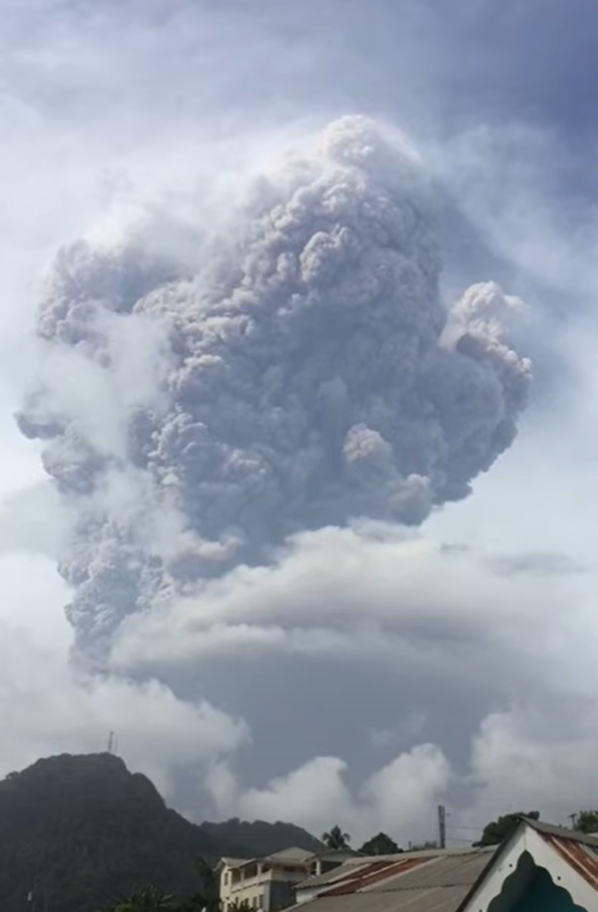
The most recent example of a Peléan eruption was the eruption of La Soufrière, on the Caribbean island of Saint Vincent. Although it had erupted many times in the past several thousand years, the volcano had been dormant for 40 years when it came to life again in 2021. Effusive eruptions began on December 27. Lava flows continued for several months while a lava dome began to form at the volcano’s summit. Several major explosive eruptions occurred beginning on April 9. Figure 5.33 is a photo taken during the April 9 eruption. Lava flows and pyroclastic flows triggered by dome collapse continued until late April. During that time, nearly 20,000 people were evacuated and another 20,000 were left homeless.
5.5.5 Plinian Eruptions
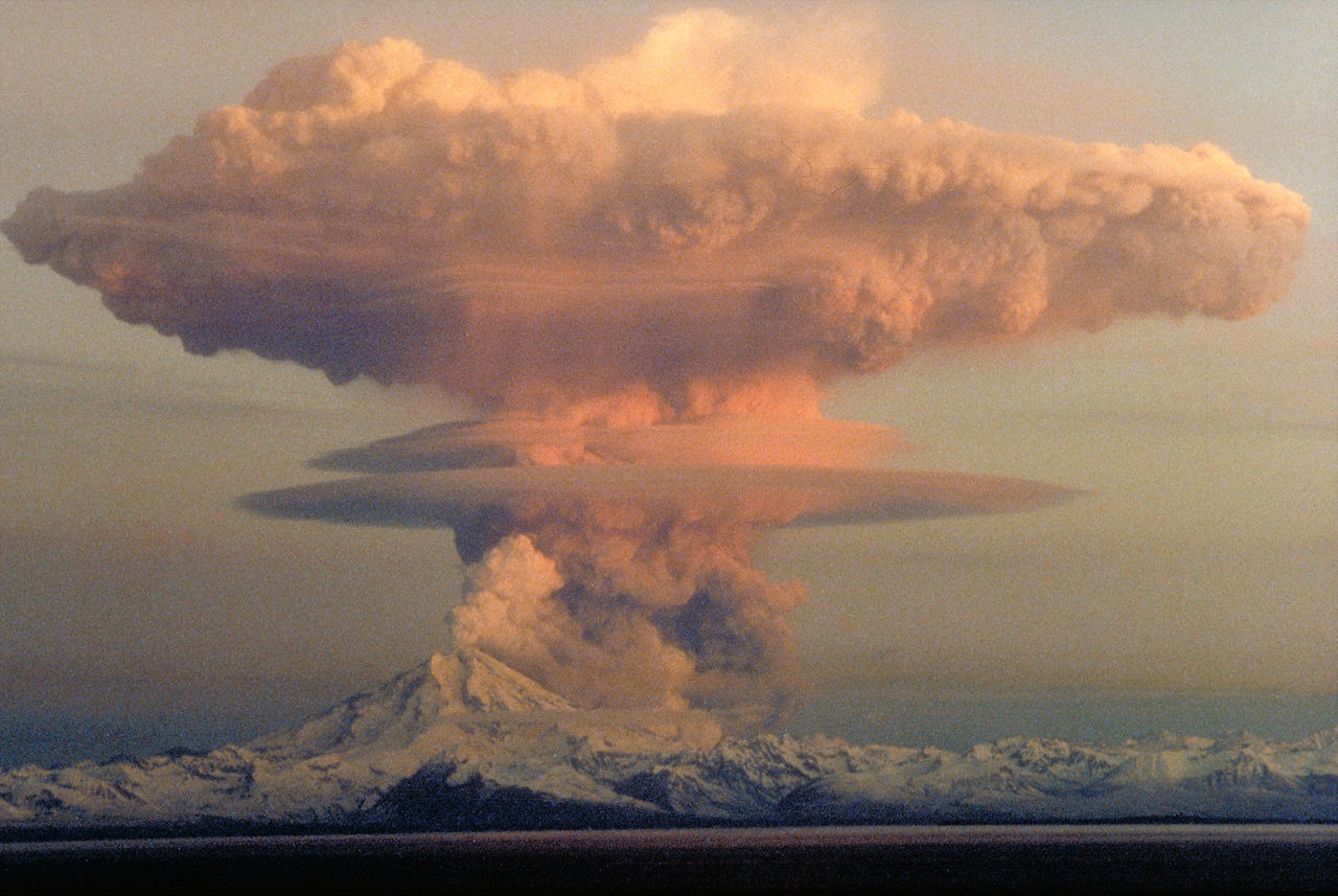
Plinian eruptions, sometimes called Vesuvian eruptions, are named for the historical eruption of Mount Vesuvius in 79 AD that Pliny the Younger chronicled. These eruptions are extremely explosive, varying from large to super-large. People can hear the explosive eruptions far away from the eruption site. Some Plinian events are short-lived, perhaps lasting less than a day, but others may continue up to many months. The photo in Figure 5.34 is a Plinian eruption of Redoubt Volcano in Alaska in 1990.
Even the smallest Plinian eruptions produce at least a cubic kilometer of pyroclastic material. They send gas and ash through the troposphere and into the stratosphere that spread out with an umbrella shape. Once pyroclastic material settles, thick ash deposits may cover large regions . Pyroclastic flows and lahars are common near the eruption source.
5.5.6 Ultra-Plinian Eruptions
Ultra-Plinian eruptions are the largest of all volcanic eruptions. They produce more than 100 cubic kilometers of pyroclastic material, and supervolcanoes, the largest of Ultra-Plinian eruptions, produce more than 1,000 cubic kilometers. Typically these eruptions are associated with the formation of large calderas and thick ash-fall deposits that cover large regions, sometimes far from where the eruption occurred. Fortunately, supervolcano eruptions are rare – the remains of about 20 have been identified around the globe. The last one to erupt was Indonesia’s Toba Volcano, about 74,000 years ago. The bottom six eruptions listed in Table 5.1 were all supervolcanoes, including eruptions of La Garita, Taupo, and Yellowstone.
● Figure CreditsUncredited graphics/photos came from the authors and other primary contributors to this book. 5.0 (opening photo) Eyjafjallajokull Volcano, Iceland, David Karna, Wikimedia Commons |

