Geologic virtual field experience to Glacier National Park, Montana:
-
- Overview
- Stratigraphy (this page)
- Structural geology
- Glacial geomorphology
The sedimentary sequence
There are three principle packages of sedimentary bedrock that we will encounter in our virtual field experience. From oldest to youngest, they are:
-
- The Belt Supergroup: Mesoproterozoic-aged shallow-ocean sediments of mixed character
- Mississippian carbonates: limestone and dolostone full of coral fossils, laid down during the late Paleozoic
- Cretaceous Western Interior Seaway siliciclastic sediments: sand and mud deposited in a vast linear sea that stretched from the Gulf of Mexico to Alaska.
There are also surficial deposits of glacial sediment that we will devote some attention to at the end of our VFE. But first, the focus should be on the really old stuff; the bedrock.
Did I get it?
The Belt Supergroup
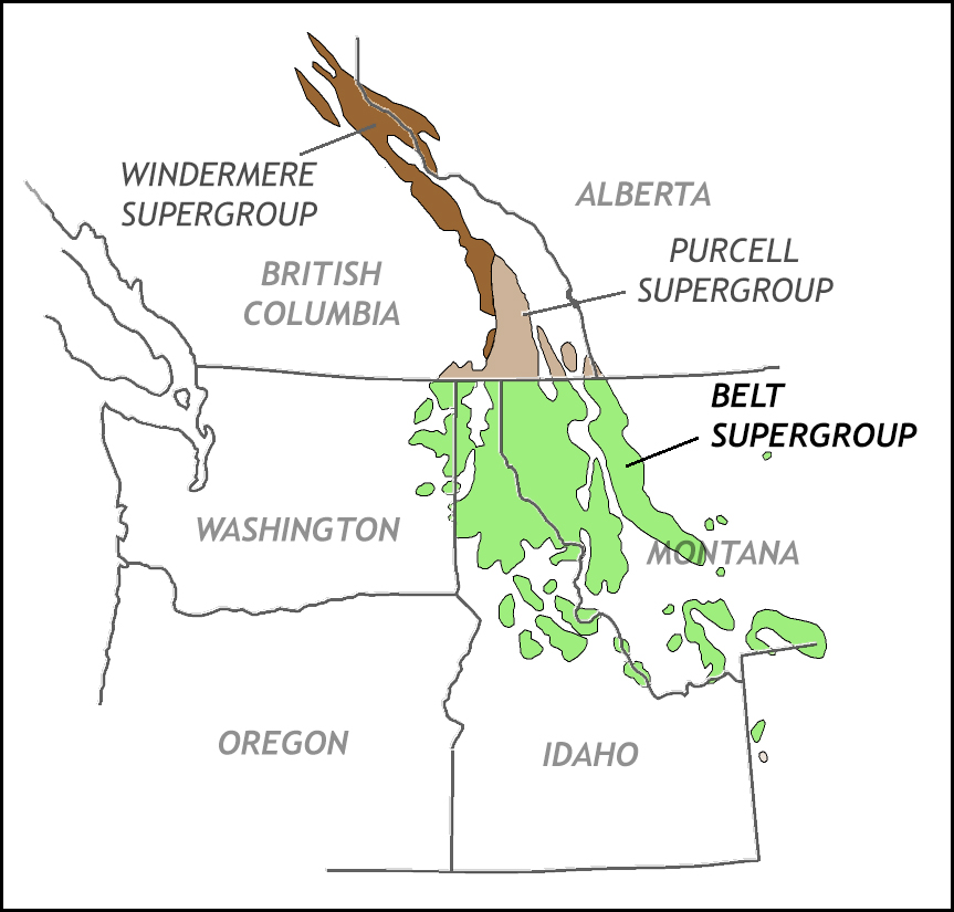
Modified from an original by Tapanila and Link (n.d.).
The Belt Supergroup is a collection of related sedimentary groups, which are each collections of sedimentary formations. For such a voluminous, inclusive definition, you might expect the Belt to be substantial in volume. You would be right: the whole supergroup is more than 15 km thick. That is 10 miles from top to bottom! It covers an area of some 200,000 km2 (77,220 square miles), including most of western Montana, much of Idaho, and portions of neighboring Oregon, Washington, Wyoming, as well as British Columbia and Alberta in Canada. It is named “Belt” for the place it was first described, the Big Belt Mountains in Montana, as well as the adjacent Little Belt Mountains. (Note that in Canada, they call it the Purcell Supergroup, but it is the same thing. Further north from the Purcell outcrops are similarly aged rocks, dubbed the Windermere Supergroup.)
Sedimentary rock types
Belt strata come in many varieties, but most are sedimentary. There are deposits of gravel and grit, sand, and clay. There are carbonates too. All have been subjected to low levels of burial metamorphism. The resulting rocks are conglomerates, quartzites, and argillites, limestones and dolostones. You will notice that some of these are sedimentary names and some metamorphic names. This reflects the Belt’s primary sedimentary nature, with a very light metamorphic overprint (greenschist facies). Belt quartzites are slightly metamorphosed quartz sand deposits; Belt argillites are slightly metamorphosed clay deposits. To further complicate things, some formations consist of one main lithology, while others show substantial internal variety.
There are also a few mafic volcanic units, and Belt rock hosts some impressive sills (of much younger age) as well.
Age and tectonic context
The strata of the Belt Supergroup were deposited in the Belt Sea, a Mesoproterozoic shallow sea that existed in roughly the same place (perhaps a bit to the west of) where we find Belt rock exposed today. This sea formed as a consequence of rifting, probably of a block of continental crust that went on to be included in the heart of Siberia. We can make such a claim on the basis of sediment deposited in the Belt Sea. Along the margins of the Belt Sea, coarser sediment dominated, with finer-grained material making it out to the center of the basin. The Lahood Formation in Jefferson River Canyon near Three Forks (or in the northern Bridger Range, for instance in Corbly Gulch) is a coarse sandstone to matrix-supported conglomerate, containing chunks of rock from the Wyoming Craton basement complex. Further west, the sediment is also coarse, and can be traced to now-Siberian source outcrops. But since the Mesoproterozoic, Siberia has rifted away and has left the vast Pacific between it and its original position on the margins of ancestral North America.
The sedimentary sequence at Glacier National Park
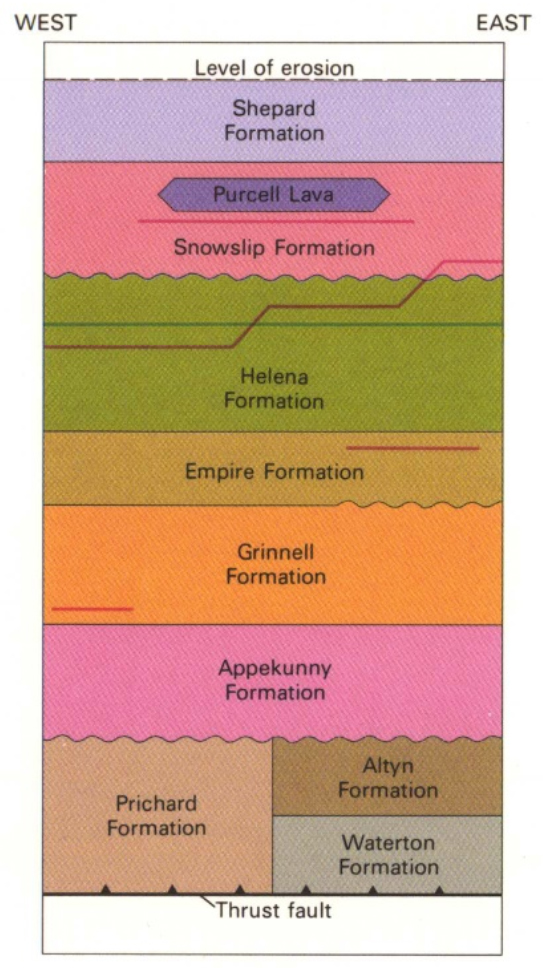
Modified from Whipple (1992).
At right is a stratigraphic column for the Belt rocks in Glacier. Diagrams like this one summarize the vertical stack of different sedimentary layers in a location.
Let us start at the bottom and work our way up, since chronologically that is the order in which nature formed these layers (i.e., the principle of superposition). At the bottom is one of two formations: either the Pritchard Formation or the Altyn Formation. The Pritchard appears on the west side of the park, and the Altyn appears on the east side. The Pritchard is a mix of black and gray argillite with some white quartzite and some limestone, while the Altyn is a gleaming white dolostone containing only small amounts of quartz sand. In Waterton Lakes National Park in southwestern Alberta, another formation is found below the Altyn, the suitably named Waterton Formation. It is mainly a dolomite, with some sand and silt in it, to varying degrees, but it does not crop out especially well in Glacier. So we will focus here on the Altyn Formation, which makes up the prominent cliffs that rise suddenly from the plains east of the park. It is about 250 m thick, and very resistant to erosion.
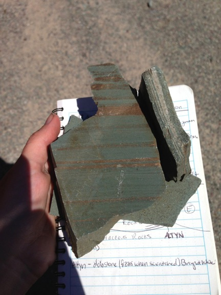
Photo by Maddy Rushing.
Overlying the Altyn is the Appekunny Formation. The Appekunny is 530 to 690 m thick, mostly green argillite in thin beds. There are some quartzite layers too. The green results from the mineral chlorite, which is a low-grade metamorphic mineral and one of the few signatures that the Belt rocks at Glacier experienced burial metamorphism. In other words, this green color is not original; it is a diagenetic feature that resulted from deep burial of the sediments.
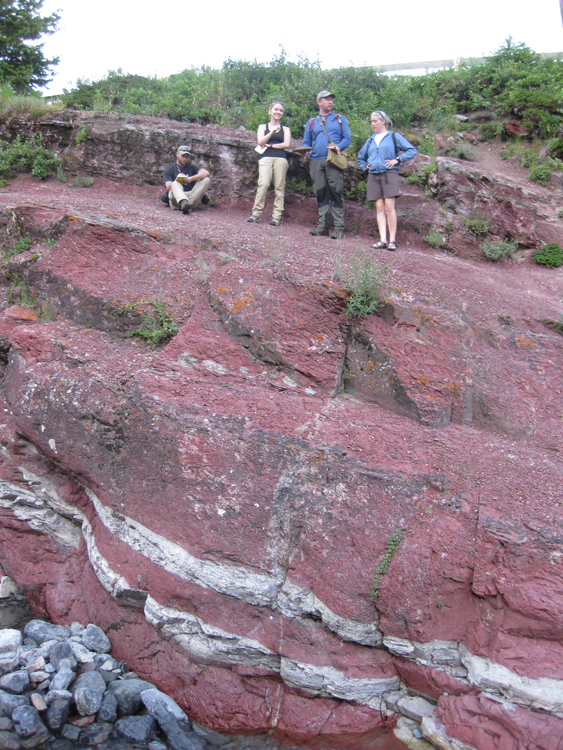
Above the Appekunny is the Grinnell Formation. The Grinnell Formation is mostly bright red argillite, but there is a lot of quartzite in it too – a higher proportion of quartz sand than we saw in the Appekunny. The argillite in the Grinnell is red because the iron in it is oxidized. The inference is that it was deposited under higher-oxygen-level conditions than was the Appekunny. Both formations’ argillites have identical proportions of iron (less than 3% apiece) but in the Appekunny the iron is reduced, and in the Grinnell it is oxidized. The difference between them is not iron content, but oxygenation state. The Grinnell is 530 to 790 m thick.
Callan Bentley photo.
The bright, bold colors of mint green Appekunny and crimson to burgundy Grinnell are striking aspects to the landscape of Glacier. Even if they do not understand what these colors mean (because they don’t speak Rock), almost every park visitor will revel in their glorious color.
The thick package of Grinnell transitions to another thick package, the Helena Formation, via a thinner transitional formation called the Empire Formation. (It is only 125 to 150 m thick.) Some geologists feel that the Empire is not distinctive enough to warrant its own formation name, but it is a well-displayed unit on the Siyeh Pass hike, so it is included it here. The Helena Formation is mostly limestone, so the Empire shows a mix of red argillite and quartzite (typical of the Grinnell) and limestone (typical of the Helena).
Callan Bentley photo.
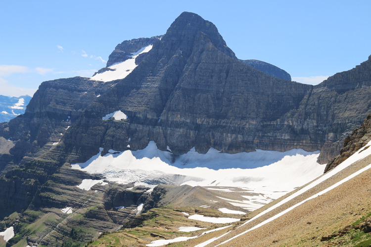
The Helena Formation proper is 750 m to 1 vertical km of bluish limestone that weathers to an appealing honey-colored tone. The Helena makes up much of the distinctive rocks in the central part of the park, including at Siyeh Pass itself and in the cirque of Grinnell Glacier. It features many extraordinarily well-developed stromatolites in a 30 m thick band called the Conophyton Zone. This band is very well exposed in the area recently uncovered by the melting Grinnell Glacier, where the massive Conophyton Zone has resisted erosion and defines the threshold of the cirque.
In the central part of the park, the Helena Formation also hosts the intrusive diorite sill that makes a distinctive black stripe on many mountain peaks in the region. The diorite sill is not a primary feature of the Helena; it was intruded much later. The Helena’s limestone strata are about 1400 Ma (1.4 Ga), and the sill likely dates to 750 Ma. The sill intruded as magma into the solid rock layers of the Helena Formation 650 million years after they were originally laid down as sediment.
The Helena is overlain by the Snowslip Formation, which is 360 to 603 m of mostly siliciclastic strata: quartzites, siltstones, and argillites of various colors, thicknesses, and characters. There are some thin stromatolitic limestones, too, particularly lower down near the contact with the underlying Helena. 95 m of the Snowslip are the basalt lava flows called the Purcell Lava.
The Shepard Formation is the youngest Belt layer exposed within immediate view of the Going-to-the-Sun Road in Glacier; it can only be seen at the highest peaks around Logan Pass. The top of the Shepard is not exposed because it has been removed by erosion, but of the portion that remains, we can say it is at least 400 m thick. It consists of dolostone, siltstone, and argillite, with some limestone and quartzite thrown in too. Like the Snowslip, the Shepard is a bit of a grab-bag of rock types.
There are a few more formations above the Shepard that crop out in high peaks in less accessible parts of the park (see Whipple’s 1992 map for all the details), but we do not need to focus on those here.
Here is a video summary of the different formations exposed along the Going-to-the-Sun Road:
Did I get it?
Primary sedimentary structures
Besides bedding, Belt strata show a variety of primary sedimentary structures. Primary sedimentary structures are patterns in the sediment that form at the time of deposition, revealing information about depositional conditions at Earth’s surface in the past. (They should not be confused with deformational structures, which are imposed much later due to tectonic stresses.) In Glacier National Park, most of the Belt strata’s primary sedimentary structures are consistent with a shallow basin.
They include:
Ripple marks
Callan Bentley cartoon.
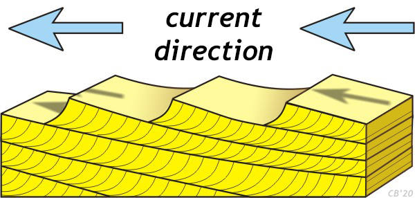
Ripples, or ripple marks, come in two principal varieties: Asymmetric ripples form in a directional current, and symmetrical ripples which form in oscillation (wave dominated) settings. In the Belt supergroup, there are both types, but asymmetric ripples dominate. These are the ripples associated with cross-bedding. How are ripples related to cross-bedding? The ripple creates a difference in water energy upstream and downstream of it. It is an obstacle to water flow. This means that the downstream side of each ripple is slightly calmer than the upstream side. The upstream side might experience erosion due to its higher-energy conditions, and the leeward side can receive that liberated sediment in a setting that is calm enough for it to settle out. The deposited sediment accumulates as a drape over the ripple, but only the concave-up “smiley face” portion of the drape is likely to survive.
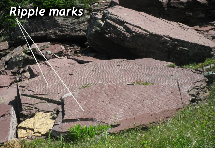
Photo by Shelley Jaye.
In other words, ripple marks are the 3D expression of this single depositional bedform. Cross-bedding is the preservation of the “internal anatomy” of a migrating ripple.
Ripples are are found in many Belt formations in Glacier, but are most prominent in the Grinnell and Empire Formations.
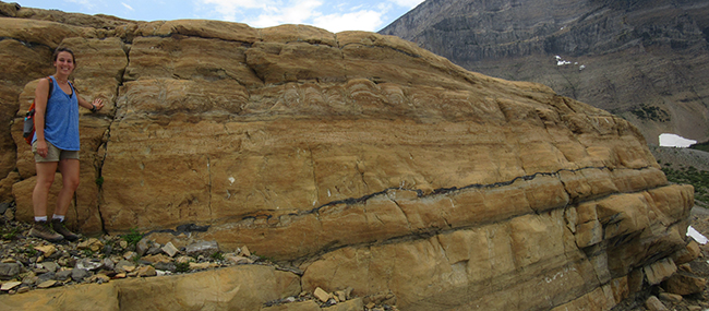
Cross-bedding
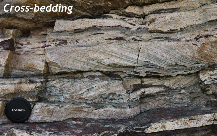
Callan Bentley photo.
Cross bedding is a primary sedimentary structure that forms in a moving current of water or air. In the strata we observe on this virtual field experience, there are not windblown (aeolian) deposits, so all cross-beds you observe are ones that formed in flowing water. As the water moves in one direction over the sediment/water interface, ripples form. In many circumstances, the “line” of the ripple will form perpendicular to the water flow direction. The ripple creates a difference in water energy upstream and downstream of it. It is an obstacle to water flow. This means that the downstream side of each ripple is slightly calmer than the upstream side. The upstream side might experience erosion due to its higher-energy conditions, and the leeward side can receive that liberated sediment in a setting that is calm enough for it to settle out. The deposited sediment accumulates as a drape over the ripple, but only the concave-up “smiley face” portion of the drape is likely to survive.
If two sets of cross-beds sit atop one another but “lean” in opposite directions, it creates a “herringbone” pattern, and should be interpreted as two different current flow directions in succession. Such bidirectional flow indicators suggest shallow water, and potentially tidal flux.
Examine this sample of Grinnell Formation quartzite + argillite to note the cross-bedding in the middle, the rippled upper surface, plus the presence of something else – chunks of red argillite surrounded by white quartzite. These are mud-chip rip-up clasts…
Mud chip rip-up clasts
When current strength is higher, clay particles remain entrained in the flow of water, and do not settle out, but because sand grains are larger (and heavier) they can settle out to be deposited. When current strength drops, clay can be deposited instead. So clay deposits (now argillite) represent relatively calm water conditions, and sand deposits (now quartzite) represent relatively energetic water conditions. But what happens when these are combined in sequence?
If energetic water precedes calm water, then you would expect a deposit of sand topped with a deposit of clay. If calm water precedes energetic water, then an initial deposit of clay may get scoured by the new, high-energy currents. Clay particles tend to stick together, while sand particles tend to disaggregate readily if blasted by high-energy water. The clay will be ripped up in chunks, which we call mud-chip rip-up clasts. These will be tumbled along in the current, potentially getting rounded as they travel. Any current strong enough to rip up mud chunks is also strong enough to transport sand, so there may also be sand grains tumbling along in the same flow. Finally, when the current ebbs, the sand and the ripped-up mud chunks will be deposited together.
Here is an example of such a deposit: showing red argillite at the bottom (high oxygen deposition), followed by green argillite (low oxygen deposition), followed by sand with rip-up clasts of green argillite. Zoom in on the rip up clasts to examine their shapes:
Desiccation cracks (“mud cracks”)
When wet, muddy sediment is exposed to the air, it can dry out. As water evaporates, there is less “stuff” in the mud deposit, and it no longer takes up quite as much volume. As a result, it shrinks. A flat deposit of mud shrinks across its upper surface, and the amount tension induced by the shrinkage is greater than the cohesive strength of the mud layer. The mud stiffens, and cracks. These cracks are widest at the top, where evaporation is most intense, and they narrow downward.
Examine this gallery to see what Glacier’s mud cracks have in common, and what distinguishes them:
 Mucracks in white argillite, possibly of the Snowslip Formation. Photo by James St. John, CC licensed.


Raindrop impressions
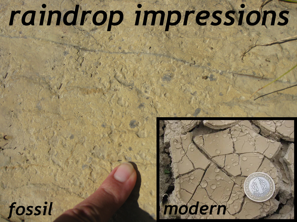
Large photo by Shelley Jaye; inset by Callan Bentley.
When mud dries out in exposure to the air, it is also subject to another distinct, uncommon, but intriguing primary sedimentary structure: little tiny craters carved out when raindrops impact. Obviously, the rain must not have been especially hard or voluminous – just a little sprinkle, like virga trailing from a passing cloud. Those delicate little divots can be preserved in the geological record for us to marvel at, billions of years later. When you find raindrop impressions in the field, it is a special moment: we have all felt a few cold drops hitting our skin as the storm passes to the south, and here is the geological evidence that the same thing happened in that exact spot, an unimaginably long time ago.
Halite casts
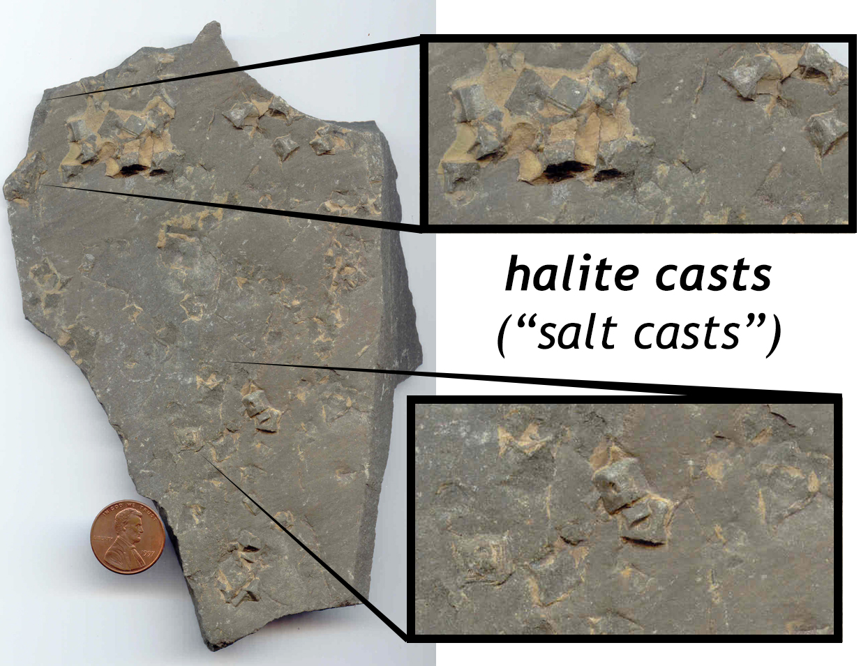
Callan Bentley photo.
When seawater dries out, it often gets saltier. The solutes in the seawater do not leave as the water does (through evaporation). When they become sufficiently concentrated, they will precipitate out. The mineral halite (NaCl; familiarly known as table salt) is one such mineral that records high evaporation conditions. The issue with salt, though, is that it is so soluble. It is not likely to persist through the geologic record in small amounts in wet sediments. However, we can still see the record of past salt crystals when they are “cast” in mud.
Here is how this works: The water dries out and gets salty. A salt crystal nucleates on the seafloor, growing in size as it adds Na+ and Cl- ions add on to the outside of the existing crystal structure. Given sufficient space, it will grow into the classic cubic habit that is typical of halite. The edges of the cube will grow faster than the center of each square face, and so some crystals may take on a “hopper” structure. Then the whole salt-encrusted layer gets buried by a new deposit of sediment: it could be clastic sediment (mud) or it could be carbonate. Either way, the salt crystals are now underneath a layer of fresh, wet sediment. The salt dissolves away in these wet conditions, and the sediment slumps inward, filling the salt-crystal-shaped hole, mimicking the shape of the original crystal with high fidelity. This “cast” has the shape of a salt crystal, but it would not taste good on popcorn.
Halite casts (“salt casts”) can be found in several Belt formations at Glacier, including the Appekunny and the Helena.
Did I get it?
Ooids
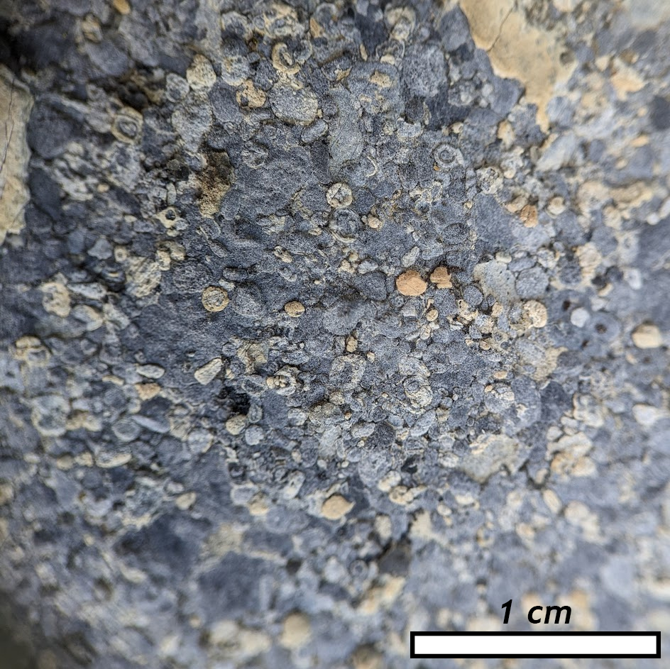
Callan Bentley photo
Ooids are small spheres of calcite, deposited in thin layers that coat some small initial “nucleus” object. They are roughly sand sized, and internally layered. Their smooth, round outer appearance makes them look like fish eggs (think caviar or the orange stuff in sushi), which is where the name comes from (ōon is Greek for egg). Ooids form in shallow tropical seas, on a bottom that is within reach of the waves. A great place to see them forming in the modern world is the shallows surrounding the islands of the Bahamas. Gently turned over by the sloshing waves, they get an even coat of calcite on all sides, resulting in their hailstone-like shape. Ooids get cemented together to make oolitic limestone.
Stromatolites

Callan Bentley photo.
Stromatolites are fossil microbial mats, typically found in carbonate strata like the limestone of the Helena Formation. They are much more common in Precambrian strata (Archean and Proterozoic) than in post-Cambrian strata, for an ecological reason: Once snails had evolved their grazing lifestyle with their rasping radula, they began to mow down microbial mats wherever they encountered them. The only places that stromatolites survive in the modern era are snail-free locations: places where the water is too salty, or the tidal currents too strong, or other circumstances that result in water good for growing stromatolites but bad for snails’ survival.
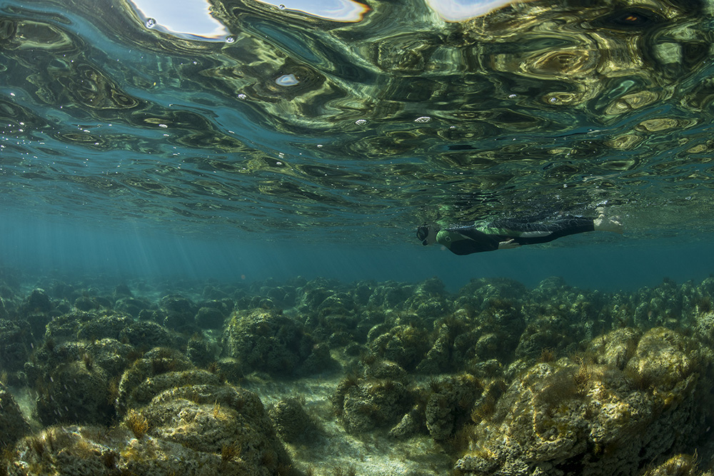
Photo by Justin Gilligan; reproduced with permission.
Modern stromatolites are survivors, but their ancestors were vital to producing the world we have now: a world where animals (yes, including snails) can survive. Specifically, they are responsible for pumping out enormous quantities of oxygen into Earth’s atmosphere. They did this because the microbes that build stromatolites were largely cyanobacteria. They were Earth’s first photosynthesizers, in other words, using their own biochemical apparatus to shred water and carbon dioxide molecules from their surroundings, building simple sugars and dumping the leftover oxygen atoms into the surrounding water. Some of that oxygen exsolved from the water, building up in the atmosphere. And some of it reacted with chemicals such as iron in the water. The Archean was an anoxic eon, but oxygen levels began to rise going into the early part of the Proterozoic. By the time of the mid-Proterozoic (when the Belt rocks of Glacier were deposited), stromatolites’ oxygen waste had accumulated to great levels in the atmosphere, allowing oxidized sediments such as the red argillite of the Grinnell Formation to be deposited.
So when you contemplate the exemplary stromatolites of Glacier National Park, a key moment of perspective should emerge: you should thank these ancient microbes for the world they built!
They typically show a domed shape in three dimensions and have many fine internal layers. Viewed in cross-section, they show a convex-upward shape to these layers. Here is a GigaPan of a stromatolite-bearing limestone that shows convex-up doming shapes in its internal laminations (very fine layers). Zoom in and explore this sample, and use the rotation tool to see what these shapes look like if they are flipped up-side-down:
Viewed in map view, they show round, semi-circular forms, with the layers showing as concentric rings. Compare these two 3D models to get a better sense of their shape.
This up-directed doming is very useful for figuring out “younging direction,” or which way was “up” when the strata were deposited, since often times strata get rotated during tectonic deformation. Sometimes they are even flipped up-side-down! Such geopetal applications make stromatolites interesting fossils as well as useful tools.
Did I get it?
Other odd fossils
The Belt strata at Glacier are older than the oldest known animal fossils (the Ediacaran fauna). As we have seen however, these rocks do contain fossil evidence, in the form of stromatolites, but those are interpreted as cyanobacterial mats. What, then, are Horodyskia? These intriguing “string-of-beads” features are found in several locations in Glacier National Park, all within the Appekunny Formation. Because of how old they are, and how big they are, they have been interpreted as some of the oldest evidence of eukaryotic life on this planet. This interpretation is controversial within the scientific community, and some workers think it is instead a pseudofossil or macroscopic manifestation of prokaryotic microbes (that is, akin to a stromatolite). Possibly it is fungal in origin, as a recent paper claims.
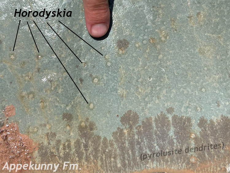
Callan Bentley photo.
There are still mysteries yet to be solved in Glacier’s sedimentary stack!
Molar tooth structure
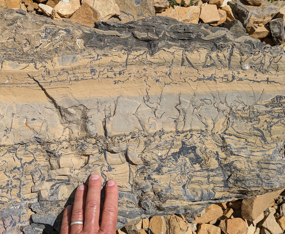
Callan Bentley photo.
Molar tooth structure is the name given to an odd feature that is especially common in the carbonate strata at Glacier (i.e. the Helena Formation). It is defined as “arrays of closely spaced, sharply defined, upright veins, and subordinate horizontal sheets and spheroids composed of calcite microspar. Veins are vertically to obliquely oriented, discontinuous, typically strongly squashed or crumpled, and often brecciated” (Pratt, 2011). It looks very messy in cross-section, and something like the upper surface of a molar when viewed on the bedding plane.
Molar tooth structure is pretty much an extinct structure; it no longer forms on this planet. The principle reason for this appears to be that animals and other organisms disturb the sedimentary substrate too much these days. This makes explaining it rather problematic. Is it related to organisms modifying the substrate in an old, no-longer-used way? Is it due to trapped gasses from decomposition of organic matter? As with Horodyskia, we do not really know. With molar tooth structure, we can make the observation that it exists, but it is hard to interpret with any confidence.
Did I get it?
A bit of lava
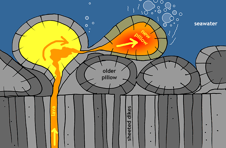
The vast majority of Belt rock is sedimentary. However, within the Snowslip Formation, there are some mafic volcanic rocks too – basalts that show both evidence of lava flow in the open air and of eruption underwater. Evidence for underwater eruption comes in the form of the primary volcanic structure “pillows” (rounded forms of chilled lava with a quenched crust, radiating vesicles, and often a distinctive upside-down teardrop shape). As for subaerial flow, pavement exposures show pahhoehoe texture, another primary volcanic structure. This “ropey” surface forms as the “skin” of basalt flows wrinkles, perpendicular to the flow direction. There are analogues in modern day Hawaii, Iceland, and the Galápagos.
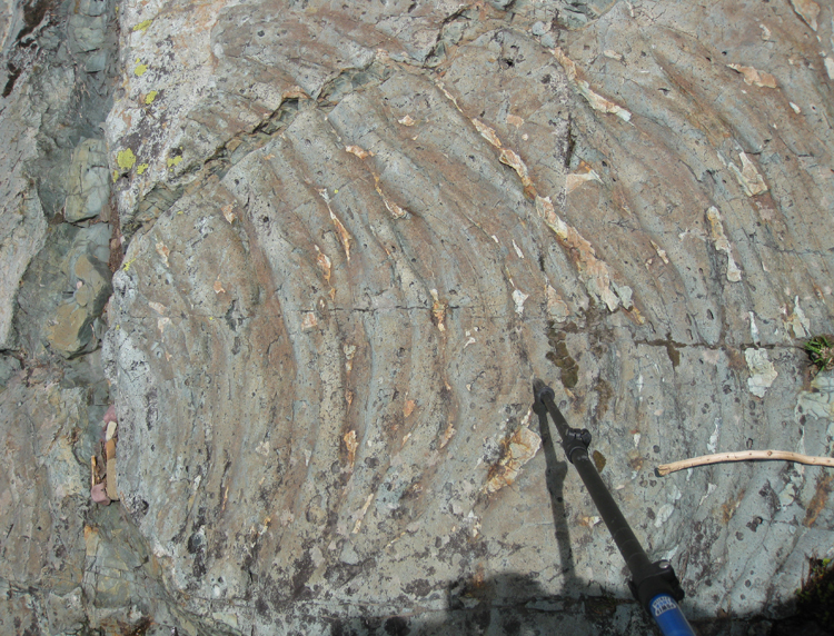
Photo by Shelley Jaye.
Sills
Callan Bentley photo.
Much later, more magma enters the story, intruding between layers of the Helena Formation to make a huge sill. This sill, which is diorite (intermediate) in composition, baked the surrounding rock as it squeezed in. This altered the adjacent limestone to a much lighter color. This “reverse Oreo” pattern of white/black/white shows up very prominently on the mountains around Glacier National Park.
Here is a gigapixel panorama showing the sill’s upper contact with the surrounding Helena Formation limestone, as exposed on Going-to-the-Sun Road. Explore it to note the change in the color of the Helena Formation as it gets closer to the top edge of the sill:
Similar mafic sills and dikes in the region have been dated at 750 Ma (Neoproterozoic). Of course, based on the relative dating principle of cross-cutting relationships, we would expect the sill to be younger than the rocks into which it intruded, but the isotopic date confirms this.
The dark sill and its flanking zones of white altered limestone are very prominent features high on mountain peaks throughout the central part of the park:
Did I get it?
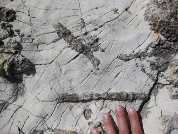
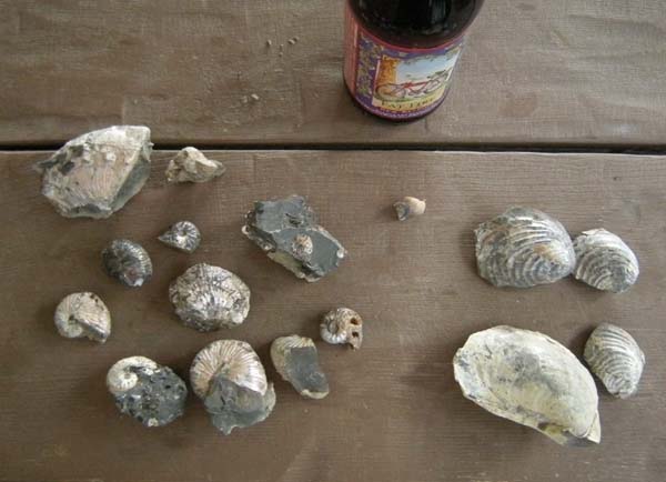
Mississippian carbonates
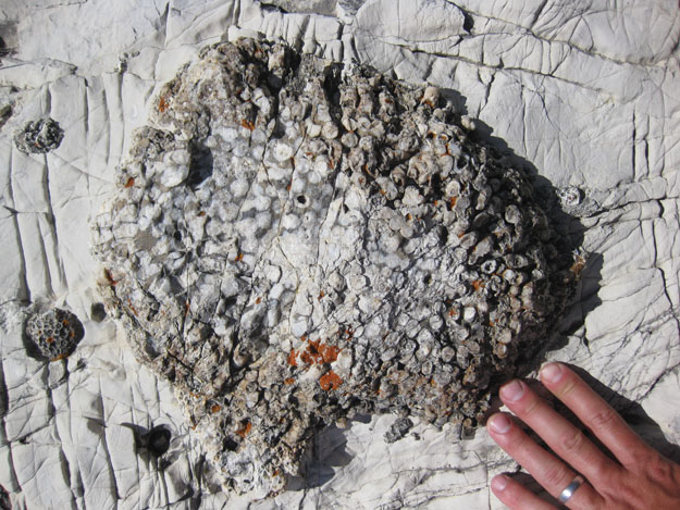
Callan Bentley photo.
There is a huge jump in time between the deposition of the Belt Supergroup’s strata and those of the next major package of sediment in our story. Elsewhere in Montana, the stories of the intervening times are well recorded and exposed. But in the vicinity of our virtual field experience, we are going to jump over those intervening times and drop straight into the Mississippian period of geologic time, about 340 Ma. This is the mid-to-late Paleozoic Era, which means it is well recorded by fossil animals, particularly marine invertebrates.
During the Mississippian, global sea level was high, and western Montana was low. Accordingly the spot that is today Glacier National Park was then flooded by shallow tropical seas. Shoreline must have been far away, as the resulting sediments are clean limestones lacking significant mud or sand content. They suggest that during the Mississippian, Montana would have looked a lot like Australia’s Great Barrier Reef, or the Dry Tortugas in Florida.
Montana was not alone in being below a shallow tropical sea during the Mississippian. The famous Redwall Limestone in the Grand Canyon was deposited during this same transgression, as were carbonate strata in many locations, even as far away as the Appalachians.
Callan Bentley photo.
Lots of fossil animals are found in these layers, ranging from crinoids and brachiopods to corals and bryozoans. These are all marine-dwelling invertebrate animals, most of which are filter-feeders. They made their hard skeletal material from CaCO3, and when they died, fragments of those skeletal remains built up in vast thickness of limestone.
The limestones are known as the Madison Group limestones. Because of the arid climate of Montana, they tend to weather more slowly than sandstones or shales, and become etched out as prominent ridge-forming units in the landscape. This climatological influence on landscape development is important: similar limestones exposed in the more humid climate of the American east are etched away to form valleys.
Here are two examples of fossils to be found in Mississippian-aged limestones in Montana:
On our VFE, we will see these carbonate strata in the Sawtooth Range (at Sun River Canyon and Swift Dam), but not at Glacier National Park itself.
Did I get it?
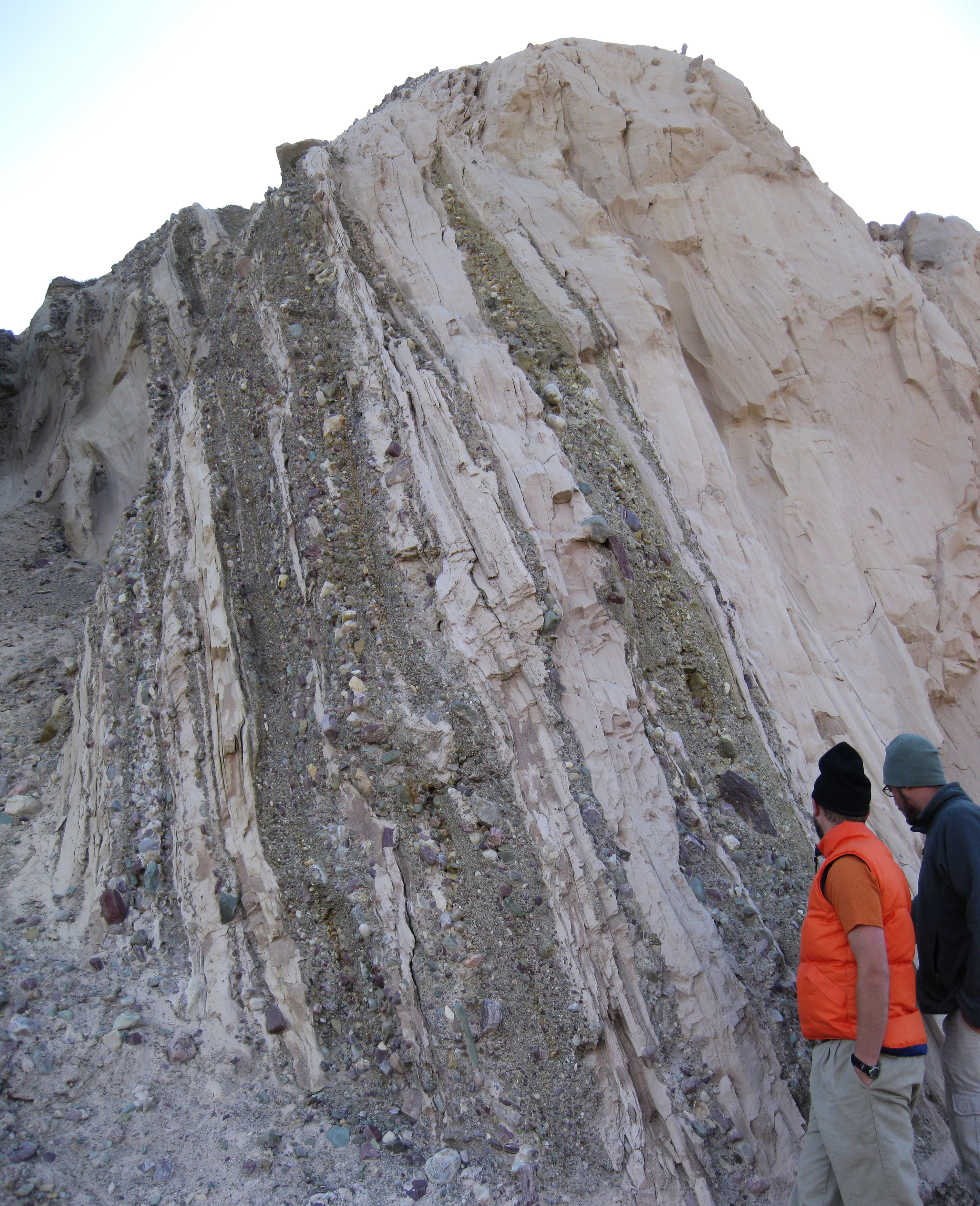
Cretaceous sediments of the Western Interior Seaway
Jumping ahead again in time, we arrive at the youngest package of bedrock in the Glacier region, a collection of Cretaceous-aged sand and mud deposits.
Tectonic context
In the Triassic, the supercontinent Pangaea began to break apart. In the Paleozoic, North America had been heading east to make Pangaea (compressing the rocks on the east coast and building the Appalachian Mountains), but by the Mesozoic, the tectonic motion of the continent shifted into reverse. The east coast became a divergent boundary, and North America began moving westward. This shift in motion opened up the Atlantic Ocean in the “wake” of the continent, with the east coast becoming a passive margin on the trailing edge of the plate. The west coast was now the focus of all the tectonic action. By the Jurassic, North America had started smashing into other landmasses and accreting new rocks along its western edge, now an active margin. Those mountains generated sediment, and those sediments were transported down and into a foreland basin to their east. The Sevier Orogeny had begun.
By the Cretaceous (say, around 100 Ma), the loading of new terranes onto the western continental margin had thickened the crust sufficiently that it subsided a bit into the mantle, both directly underneath the mountains, but also the neighboring crust too. This was a time of vigorous seafloor spreading around the world, so sea level was already high. It was also a time of extreme global warming, with no evidence for glacial ice anywhere on the planet. So there was lots of water in the oceans, but there was also a lot of oceanic ridge volume, displacing water, and now crustal loading of earliest Sevier mountains caused the continent to the east of the range to flex downward. This allowed the development of a substantial sea to develop, stretching from the Gulf of Mexico to the Arctic Ocean. This was the Western Interior Seaway.
Examining this virtual globe will give you a sense of the incredible extent of the Western Interior Seaway:
Earth as it appeared in the middle Cretaceous period of geologic time. Find ancestral North America and note the band of water running from the Yukon to Texas through the middle of the continent. This is the Western Interior Seaway. This dyanmic visualization was created by Ian Webster using tectonic and paleogeographic maps by C.R. Scotese’s PALEOMAP Project, and is embedded here with permission. Grab it and spin it around! Zoom in and out! Explore!
Sedimentary facies
The Western Interior Seaway changed size as sea level rose and fell, so sometimes it was wider and sometimes it was more narrow. In the vicinity of Glacier National Park, if the seaway was in a “wide” phase, then the water was deep at Glacier (i.e., it was an offshore marine facies), and that was principally recorded in the form of lots of black mud. When the seaway was “narrow,” the Glacier region hosted the seaway’s shoreline, a circumstance recorded by sandier, higher-energy, higher-oxygen deposits. At times when sea level was especially low, the area around Glacier was exposed above sea level (making it terrestrial). Fortunately, plenty of rivers were draining the Sevier Mountains to the west, and dumping plenty of the resulting sediment on their way downhill toward the Western Interior Seaway.
Callan Bentley photo.
The deepwater deposits of the Western Interior seaway host fossils of marine organisms, including oysters, squid relatives called belemnites, ammonites, and massive marine reptiles such as mosasaurs and sea turtles such as Archelon. At Swift Dam, exposures of the deepwater shales include the “Devil’s Toenail” oyster more formally known as Gryphea, as well as belemnite fragments that look like translucent brown bullets.
The shoreline facies deposits of the Western Interior Seaway host the fossil remains of terrestrial organisms, most notably dinosaurs. Sites like Egg Mountain near Choteau or Dinosaur Provincial Park in Alberta are terrestrial, and retain an astounding record of these fascinating creatures.
Most of the Cretaceous strata cropping out at the locations visited by this VFE is black shale, but about a third of it is sandstone. You can tell the two apart, even at a distance, by two variables: (1) shale is darker colored (sandstone is lighter) and (2) shale weathers into crumbly slopes (while sandstone weathers in blocky ridges). Formation names include the Blackleaf Formation, the Kootenai Formation, the Marias River Shale, the Bearpaw Shale, the Virgelle Formation, the Two Medicine Formation. For the purposes of this VFE, we will not distinguish among these, lumping them all together instead: a lot of sandstone and black shale.
Here are three examples of representative outcrops, placed in order of most-shale-dominated to most-sand-dominated… And therefore more-offshore/deepwater to more-nearshore/shallow water. Explore each to estimate the proportion of shale to sandstone:
You will also have noticed in each of those GigaPan images that the strata are not in their original horizontal orientation, implying serious tectonic deformation after they formed. We will cover that in the next major segment of this VFE.
Did I get it?
Pleistocene sediments
Callan Bentley photo.
Glaciation during the recent Pleistocene ice ages served not only to sculpt the landscape by removing rock, but then the resulting debris was deposited as sediment. Glacial “till” was deposited directly by glacial ice, and glacial outwash sediment called “drift” was deposited by rivers flowing away from the glacial termini. Where these rivers were impounded by moraine dams, lakes formed, and in these lakes, glacial silt settled out. Glacial icebergs floating in these lakes rafted dropstones out to calm-water sites. You can learn more about this sequence of sediments in the final excursion on this virtual field experience. For now, it is enough to know that there are patchy Pleistocene deposits on top of the Belt strata, the Mississippian carbonates, and the Cretaceous siliciclastic strata of the Western Interior Seaway.
Did I get it?
Further reading
James L. Dyson (1957). The Geologic Story of Glacier National Park. Special Bulletin No. 3; Glacier Natural History Association, available online from the National Park Service.
Mikhail A. Fedonkin and Ellis L. Yochelson (2002). “Middle Proterozoic (1.5 Ga) Horodyskia moniliformis Yochelson and Fedonkin, the Oldest Known Tissue-Grade Colonial Eucaryote,” Smithsonian Contributions to Paleobiology, p. 1–29. https://doi.org/10.5479/si.00810266.94.1
Alex T. Feucht (1971). Geology of the Swift Reservoir Area, Sawtooth Range, Montana. M.S. thesis at the University of Montana.
Lori Tapanila and Paul Link (n.d.), “Mesoproterozoic Belt Supergroup,” a module in the Digital Geology of Idaho website.
Brian Pratt (2011). “Molar-tooth structure,” chapter in Encyclopedia of Earth Sciences, p.662-666.
Omar B. Raup, Robert L. Earhart, James W. Whipple, and Paul E. Carrara (1983). Geology along Going-to-the-Sun Road, Glacier National Park, Montana. Glacier Natural History Association.
(2013). “Problematic Mesoproterozoic fossil Horodyskia from Glacier National Park, Montana, USA,” Precambrian Research 226, p. 125-142.
Don Winston and Paul K. Link. (1993). “Middle Proterozoic rocks of Montana, Idaho and Eastern Washington: The Belt Supergroup,” in Reed, Jr, J.C., Bickford, M.E, Houston, R.S, Link, P.K., Rankin, R.W., Sims, P. K., and VanSchmus W.R., eds., Precambrian: Conterminous U.S.: Boulder, Colorado, Geological Society of America, The Geology of North America, v. C-2, p. 487-517.
Chapter Contents
- 1 The sedimentary sequence
- 2 The Belt Supergroup
- 3 Mississippian carbonates
- 4 Cretaceous sediments of the Western Interior Seaway
- 5 Pleistocene sediments
- 6 Further reading