Stratigraphy
The view from Cedar Mesa near Bluff, Utah. Several thousand feet of stratigraphic record are recorded here, visible due to the benevolence the downcutting of the San Juan River as the Colorado Plateau continues to uplift. (Source: Kohrs, Russell)
“Time, which measures everything in our idea, and is often deficient to our schemes, is to nature endless and as nothing; it cannot limit that by which alone it had existence; and as the natural course of time, which to us seems infinite, cannot be bounded by any operation that may have an end, the progress of things upon this globe, that is, the course of nature, cannot be limited by time, which must proceed in a continual succession.”
James Hutton, “Theory of the Earth”, 1788
The Story of Basins Past, Present, and Future
Plates move and collide, mountains rise, sea level ebbs and flows. All the while, chemical and physical weathering processes, buoyed by important interactions between the Earth’s spheres, break rock down in place. After it breaks down, erosional forces powered by gravity and aided by wind, water, and ice provide the energy and work necessary to move weathered materials downhill, downstream, into a new place of rest. The story of these weathered sediments, large and small, has great variety. Numerous variables determine the outcome for these sediments. Latitude, the parent rock that weathered, the climate and degree of physical and chemical weathering, life forms that interacted with the grains, and so many more ultimately determine the story eventually told by the layers of sediment. As these layers accumulate, so does the tableau of stories they tell.
Strata
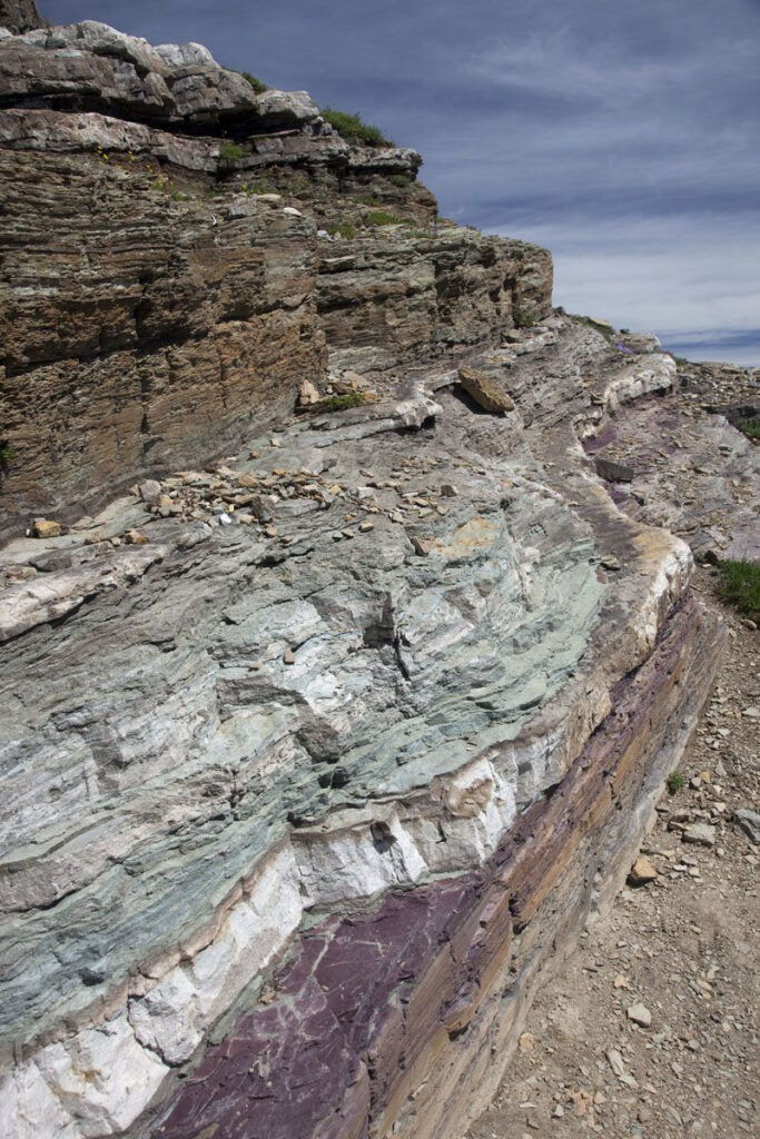
Used with permission for educational purposes from Marli Miller Photography.
Sedimentary rocks come in strata, or layers, much like a nice birthday cake or pages in a storybook, and stratigraphy is the study of the record of these layers. These rocks are formed from sediments originally deposited in a basin. A basin is an area of depressed elevation generally surrounded by land at higher elevations. Basins can be on dry land or be filled with freshwater or saltwater. Over time, the land surrounding a basin erodes and the resulting sediment begins to fill the basin. From the point of origin in the highlands to the point of deposition in the basin, a great deal can happen to this sediment. Weathering, in various physical and chemical forms, takes its toll. By the time of their final moment of deposition, these sediments record a memory of their former existence as rocks, of their transport journey, and of processes that occur in the basin. Much of this sediment is solid and arrives as particles. Some of it arrives in aqueous solution, becoming the salts we experience in the seas around us. Some of it forms in the bodies of organisms, such as carbon-rich plant tissues or the skeletal remains of animals.
Depending upon the distance particles travel, some will remain the size of massive boulders and some will be reduced to the size of tiny flakes of clay. The range of grain sizes, or sorting, is the result of weathering and subsequent changes in energy as the particles move downslope. Some are well-rounded, others still retain their rough edges. Some sediment, found far from its source, will be composed primarily of quartz, with less stable minerals having rotted away. Other sedimentary deposits will still contain unweathered minerals like micas and feldspars. Once deposited, sediment and rock will begin to undergo physical and chemical processes associated with the local environment. Soil formation will begin on land. In marine settings, chemical processes associated with water chemistry and biogenic materials will occur, adding onto the earlier story of transport. These layers of sediment, accumulating over time, are the subject of stratigraphy.
(Wikipedia Commons)
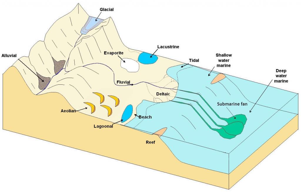
The journey a sediment grain takes ultimately ends with deposition in a basin. Throughout that journey, sediments will take up residence for a time, waiting for a sufficiently energetic event to move them further along toward this end. The collective experience of sedimentation along these myriad pathways creates situations, as illustrated above, where different depositional environments are created. Geologists refer to the unique sedimentary characteristics of these varying environments with the term “facies“. A sedimentary facies is defined as the body of characteristics of a sediment, or rock, that are indicative of the environment of deposition at the time. Real-time facies migrate, or change, at a location as conditions change. All of the environments in the figure above are dynamic in nature. We can also assume, using uniformitarianism, that similar environments have existed in the past, producing rocks in the geologic record that record similar characteristics we see in their modern counterparts. As sediments deposit and facies migrate, strata are generated. Geologists call such strata, beds. As beds representing similar environments accumulate and lithify, they will come down to us as mappable units called formations.
All of this action ultimately occurs in sedimentary basins.
Basins
Basins can be thought of as a library filled with books, which are the layers of rock that accumulate. These layers tell the story of global geologic changes, regional changes, and changes within the basin itself. There is great variety among sediments and other materials deposited in basins and in the layers, or strata, that they create. This variety and layering provides the equivalent of text on the pages of a novel or even in this textbook. Individual pages are the strata, or beds, and their characteristic portion of the story on that page are the facies. These pages are laid down horizontally, building up vertically over time, reflecting the order in which they occurred (superposition). Eventually, these pages (beds) accumulate into books (formations). Processes that occur after deposition, such as lithification, deformation, and further weathering and erosion can then make changes to this record that are akin to the deterioration seen in ancient Egyptian papyrus, or in a book whose pages and cover have been subject to the ravages of the elements. Strata can be torn (faulting), wrinkled (folding), or younger material may be injected (igneous intrusions). Depending on the context, these modifications may provide some confusion or clarification to the overall story. Over time, some of the material that makes up the strata and rock of this “book” can be lost or altered (erosion, metamorphism, secondary chemical alteration, etc.). Sometimes, even entire pages, or beds, are removed. Entire books, or formations, can be truncated, leaving gaps in the storyline (unconformities). Stratigraphers grapple with a record that was incomplete to begin with, and is further reduced over geologic time. Still, the remaining story these layers of sediment have to tell is powerful and important. It is of critical value in providing a more complete understanding of the history of our planet, including your own home landscape. Geologists who study this record are called stratigraphers. They are the historians within the geosciences.
Consider the office bookcase below as a stratigraphic metaphor:
Facies – The words, notations, etc. on an individual page of a book;
Beds = Pages within periodicals or books;
Formations = Books full of pages, come complete, some perhaps incomplete;
Groups of Formations = Shelves of books with similar topics (assuming they are organized as in a library!);
Bookcase = Stratigraphic record of the entire basin.
The limitation of this metaphor is that most of the “stratigraphy” you see here is vertical, implying a great deal of geologic alteration. Putting that aside and remembering the “Principle of Original Horizontality”, we know that if these were rocks, they would be stacked differently.
The gigapan below depicts the Hampshire Formation. It was taken along Corridor H (US 48) in West Virginia. The image depicts a single formation. If you observe this formation, akin to a book, you may first see the varying color. These are beds. Some of these beds, or pages, could be broken down further into smaller beds. Ultimately, these beds are all related because they were deposited in similar depositional environments, as illustrated by their facies.
(Source: By The original uploader was Maveric149 at English Wikipedia. – Transferred from en.wikipedia to Commons., CC BY-SA 3.0, https://commons.wikimedia.org/w/index.php?curid=2257589).
Layers of sediment are not static recipients of the story only. They are also participants. As we will learn in the next section, they are recording their story and being acted upon by outside forces such as tectonic change, sea level change, and lithification. But, they are also having their own impact on tectonics and sea level. Layers of sediment also play an important role in the record of geologic history that is important to understand also. As these layers accumulate in basins, they record the history of an area. Stratigraphy is the study of that history.
Basins, Sea Level, and Accommodation Space
What is a Basin?
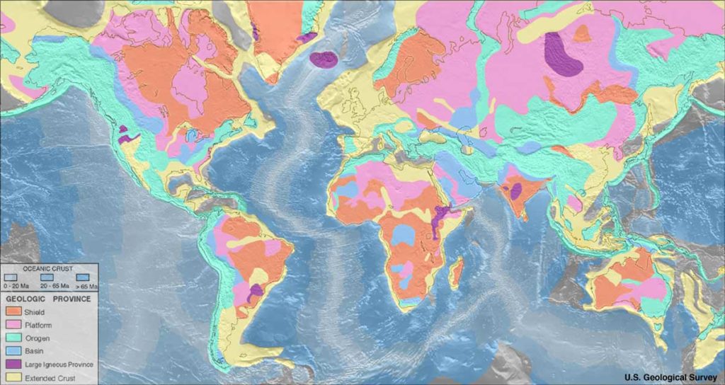
Sedimentary basins are geographic depressions where sediment accumulates. Some basins are epicontinental; they reside on top of the continental platform. Other basins are tectonic, located around the margins of the continents, after the continental shelf break. The power of stratigraphy lies in its ability to help scientists understand the history of basins in general. Basins sometimes contain water and sometimes do not. If the basin is dry, as with Death Valley, California, then the primary control on the creation of stratigraphic sequences would be changes in tectonics, such as the uplift or subsidence of the land itself. If the basin is connected to a body of water, then the cyclical rise and fall of this water will be recorded in the material deposited in the basin. Climatic and astronomical factors can cause changes regionally or locally that can affect the level of the water. The melting of ice or the thermal expansion of water are among the variables that can cause sea level to rise in a basin. Such changes typically do not occur within the lifespan of a single human. The record left behind is the pattern of sedimentary deposits. This pattern is preserved when the sediments become sedimentary rocks, and reading it is how we understand the history contained in this deep time.
The long-stable igneous and metamorphic cores of the original continents are referred to as cratons. Some portions of these cratons are exposed at the surface and some other portions are covered with blankets of sedimentary rock. The exposed portions are called shields. The portion of the craton that is buried is referred to as the platform. It is on these platforms where basins exist and where sedimentary strata accumulate.
First, sediments accumulate as individual beds. Eventually, groups of beds that are widespread enough to be geologically long-lasting will be referred to as formations. Platforms make up the continental areas in which formations accumulate. The stacking of formations is like adding pages to a book. Some platform environments are dominated by carbonate sedimentation while others are dominated by siliciclastic sedimentation.
(Wikipedia Commons)
All basins have limited space. The interplay between tectonic changes, global sea level, local water level, and sediment accumulation all affect changes in space within any given basin. This “accommodation space” is the volume of available within a basin to accommodate influxes of sediment. This concept will be dealt with in a bit more detail in chapter on “Sequence Stratigraphy.” Accommodation space is not static. It adjusts as changes occur in tectonics, sedimentation, water level, and global (eustatic) sea level. As Earth’s systems interact over time, the ability of a basin to accumulate sediment or even the amount of sediment being produced fluctuates. This is true of all basins.
Types of Basins
Several types of basins develop in different tectonic situations, each bearing the distinctive signatures of the conditions under which it originated. Let’s now examine the sedimentary basins that form in divergent tectonic settings, convergent boundaries, and along strike-slip fault systems.
Rift Basins
As divergent boundaries rip apart a plate, a rift basin is produced. Similarly, at convergent subduction zones, rifting in a backarc basin can open up accomodation space for sediment. The character of such basins evolves significantly as the rift widens. Basins created by rifting occur along the edges of continents and well within the interior of the continent. At first, the basin will be intracratonic. This kind of basin is landlocked. Subsidence, a drop in land elevation, will occur as the rift develops due to thinning of the lithosphere. Once the topographically low rift develops a body of water, the nature of the depositional setting will also change. The result is an epicontinental basin.
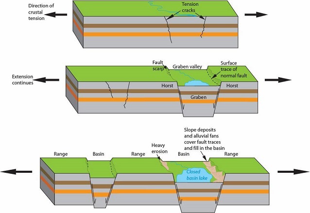
(Source: National Park Service, Trista L. Thornberry-Ehrlich, Colorado State University.)
In these locations, basins form as the graben subsides during the ripping apart of the crust. At this point, the basin may be entirely devoid of water and in fact will stay dry unless it intersects with a body of water or is not located in a wet climate.
In the case of the East African Rift, the only bodies of water within the rift valley itself are lakes fed by rivers. The thinning of the lithosphere in such basins can lead to volcanism. The East African Rift, as depicted below in two images, is an excellent example of an intracontinental rift basin that contains active volcanism. Famous mountains like Mt. Kilimanjaro, Mt. Kenya, Oldoin’yo Lengai, and others have important places in the cultural traditions and mythology of the people from these areas. They also present an interesting array of igneous materials.
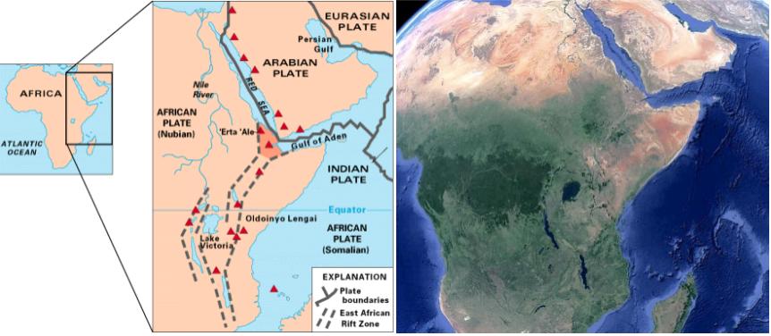
(Wikipedia Commons)
GigaPan of Lake Borgoria with Geysers
Passive Margins
Our modern ocean basins are the ultimate in sedimentary basins. Many of them, the Atlantic Basin in particular, are the result of ancient rifting. These ancient rift margins are also referred to as “passive margins“. Major tectonic activity is generally absent at these locations. These are basins where active sedimentation is occurring. The characteristic of the sedimentation is, as always, dependent upon the environment, its energy regime, and other factors. The character of local sediment is indicative of its facies. As such, what you find at a passive margin beach, like Myrtle Beach, SC, is very different than what you find well off of the continental shelf in the abyssal plain, where you might find a siliceous or calcareous ooze.
The GlobSed map below, compiled by the Center for Earth Evolution and Dynamics, illustrates the current positions of epicontinental marine basins around the globe today. It also highlights their thickness. Note that many of the very thickly sedimented basins are where major rivers flow into the ocean. The Gulf of Mexico is one, but also the Mediterranean Sea, and the Bay of Bengal. Nearly every continental margin outside of the Pacific Ocean (and even some of those are!) are examples of very ancient rift basins. It is worth noting that land-based rifting, such as in East Africa, is not highlighted here due to the nature of this data.
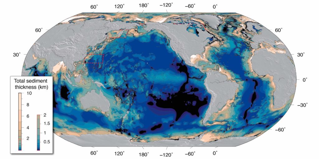
(Straume, E.O., Gaina, C., Medvedev, S., Hochmuth, K., Gohl, K., Whittaker, J. M., et al. (2019). GlobSed: Updated total sediment thickness in the world’s oceans. Geochemistry, Geophysics, Geosystems, 20. DOI: 10.1029/2018GC008115)
Sedimentation in Rift Basins
All sediments that have accumulated in the basin have resulted from the weathering of the horsts that form the surrounding mountains, from the materials erupted by volcanoes, or from the marine or freshwater itself that has filled the basin. Rift valley basin sediments are a mix sediments from all of these sources. Sedimentary beds formed from surrounding mountains are dominated by quartz and feldspar, often producing arkosic sandstones. The East African rift meets up with two other rift zones in its northeastern-most area, the Gulf of Aden and the Red Sea, both of which are flooded rift valleys. These areas record not only the sediments weathered during the early opening of the rift, but also now the substantial accumulations of material deposited in these seas. The shorelines of the Gulf of Aden and the Red Sea, like the shorelines of all landmasses on the margins of rift zones, represent passive-margin deposition.
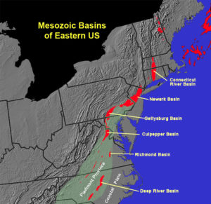
The east coast of the United States is an example of a very ancient passive margin, a remnant of the rifting of Pangaea. Key evidence for this not only comes in the form of the Mid-Atlantic Ridge itself, but in the array of Triassic/Jurassic rift basins that run parallel along the east coast from Nova Scotia south into North Carolina. Over the intervening millions of years, there has been ample time for coastal wave action along the Coastal Plain of these states to winnow out most everything but quartz sand. Eventually, such passive margin sands will produce excellent sandstone rich in quartz and poor in other minerals. These are referred to as quartz arenites.
(Wikipedia Commons)
Not all rift zone basins flood with water, and none rift forever. Some rift basins fail and stop rifting. Others continue rifting for hundreds of millions of years, forming ocean basins like the Atlantic Basin. At some point, a rift basin will cease its stretching due to changes in tectonic stress. When this happens, space within the basin will be reduced as eroding sediments continue to fill the basin until there is no “accommodation space” left, barring further tectonic or isostatic changes. While the basic storyline is very similar for any kind of rift basin, the types of sediments deposited and resulting secondary changes will define the story in much greater detail.
Subduction-Related Basins
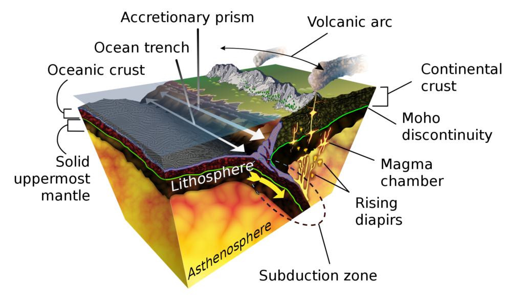
(Wikipedia Commons)
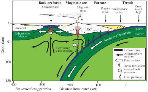
At subduction zones, there are three basins where sediments can accumulate. These include forearc basins, backarc basins, and the trench. Trench basins are deepwater settings formed where the subducting and overriding plates meet. Forearc basins form between the volcanic arc and the trench. Backarc basins form opposite the subduction zone, on the other side of the volcanic arc. Because of the tectonics involved, backarc basins tend to be extensional in nature. Such basins were discussed in the section on rift basins above. In the cross section below, the setting is an oceanic island arc and the backarc basin has thinned enough to develop into a rift basin. Backarc basins need not be submerged by water, as they can also occur on land.
Sediments in Subduction Zone Basins
Trench basins source their sediment from three sources: those sediments produced in the water column, those weathered from the overriding plate, and those scraped off of the subducting plate. Some sediments are generated in the water column by organisms that then rain down into the trench. These are generally siliceous, but can also be carbonate, if the depth is not too great. The balance of the sediment comes from land, sometimes via submarine mass movements like turbidity currents. Finally, sediment is conveyed to the trench atop the subducting plate, sometimes riding passively over great distances.
Forearc Basins
(Wikipedia Commons)
Forearc basins form between the accretionary wedge and the volcanic arc areas of a subduction zone and can occur both on land and underwater. The location of the foreland basin is dependent upon whether the subduction occurs between oceanic and continental lithosphere, or oceanic and oceanic lithosphere. In all cases, the basin is the result of downwarping, or flexure, of lithosphere created by the subducting plate. Such basins will contain a mix of siliciclastic material weathered off the volcanic mountains on its margin, volcanic deposits formed during eruptions of the volcanoes on the overriding plate, along with biochemical sediments from life forms living within any water in the basin. Lithic sandstones are common in such basins because sediments do not travel long distances before deposition. An excellent modern example of a forearc basin can be seen in the Central Andean Forearc in South America. At this location, there are actually two forearc basins, the Atacama Bench and the Iquique Terrace.
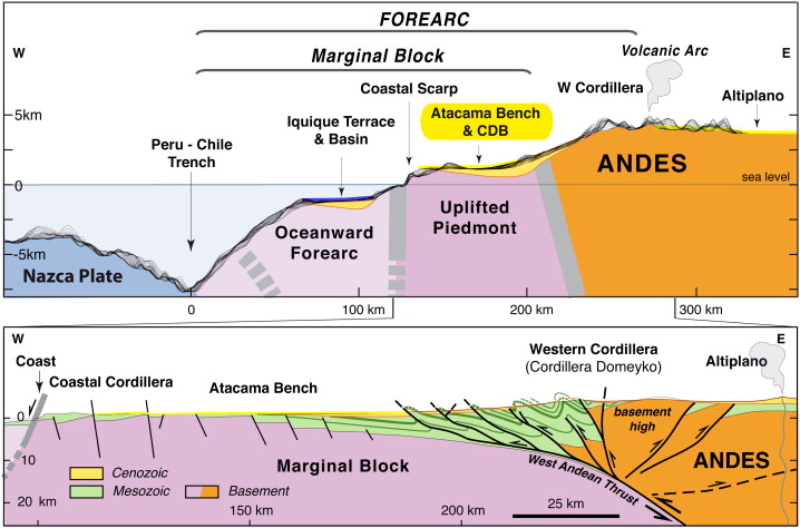
(Used with permission: Armijo et al., 2015).
Because of the compression involved with the tectonic processes in these areas, the sediments have often undergone intense metamorphism, leading to large amounts of secondary mineralization. These metamorphic signatures, such as those contained in the Franciscan Blueschist below, are important for historical context. Before metamorphism, these were ocean floor sediments, deposited in a basin. They were then scraped up as subduction occurred and altered to their present form. The metamorphism itself is a part of the history of these sediments, even if the rock is no longer sedimentary. It is a great example of how non-sedimentary rocks are also important players in teasing out the stories rocks have to tell.
Franciscan Blueschist GigaPan
Foreland Basins
Foreland basins are the inland portion of the backarc region at subduction zones. They form parallel to mountain belts. They result from the massive crustal thickening and the downwarping of this increased mass on the lithosphere. This process is called lithospheric flexure. These basins vary in width according to the ability of the underlying lithosphere to flex. In all situations, the primary sediment flux into foreland basins is material eroded from the nearby mountain belt. Sedimentary strata are much thicker when proximal, or close to the mountains, and thinner in more distal, or far away, areas from the mountains. The thickness of the strata of sediment contained in such environments can provide information about the depth and lateral extent of the ancient basin. Studying these details helps sedimentologists apply these same principles to ancient foreland basin environments, resulting in more accurate models of basin development.
(Wikimedia Commons)
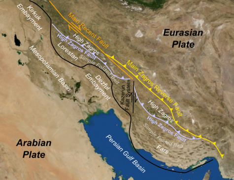
There are many excellent modern examples of active foreland basin deposition. For example, the Persian Gulf is the foreland basin for the Zagros Mountains of Iran.
Many ancient examples of foreland basins exist across North America. During the development of the Appalachians, the successive Taconian, Acadian, and Alleghenian Orogenies left behind a record of successive foreland basins deposits. These “sequences” of sediments form the Valley & Ridge province of the Appalachian mountain belt, and will be discussed later in this chapter. Their sedimentary record is prevalent along the eastern coast of North America, from Maritime Canada to northern Alabama and Georgia. Beginning with the limestones of the “Great American Carbonate Bank” of the Cambrian and Ordovician Periods, these sedimentary strata represent thousands of feet of deposition over several hundred million years. The most recent layers, deposited as the ancient supercontinent of Pangaea developed during the Permian Period, make up the hills west of the Appalachian Mountain chain. These Appalachian foreland basin strata contain economically important deposits of coal and natural gas. These deposits are evidence of the ancient seas and swamps that once existed in these regions.
In the Cretaceous North American west, another important foreland basin developed that is known as the Western Interior Seaway. This seaway not only preserves some of the most marvelous marine invertebrate and reptilian fossils from that period, but also some of the iconic and important dinosaur fauna that lived in coastal environments of the time.
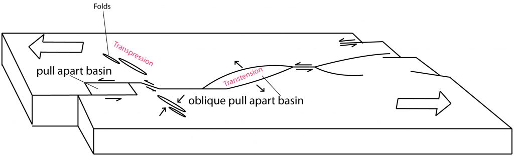
Strike-Slip Basins
Strike-slip basins, or pull-apart basins, form due to the pulling apart and resulting subsidence of land along strike-slip faults. They can also form along transform boundaries. As shearing forces rip the lithosphere, blocks of lithosphere can detach and drop down relative to the surrounding land. This lateral and diagonal motion and associated subsidence should not be confused with the subsidence of horst and graben structures discussed earlier in rift basins. Good modern examples of such basins occur along the San Andreas Fault Zone in California and the North Anatolian Fault Zone in northern Turkey. In the San Andreas Zone, a classic result is the generation of the Gulf of California, running between the Baja Peninsula and the northwestern Mexican state of Sonora. This basin is the result of a series of pull-apart strike-slip basins that have effectively led to enough subsidence that the region has been infilled with significant amounts of water, forming the narrow Gulf seaway. Smaller examples can be seen along the Hayward Fault in Fremont, California.
(By Wtbarron – Own work, CC BY-SA 3.0, https://commons.wikimedia.org/w/index.php?curid=32163143).
Sediments in Strike-Slip Basins
Sediments in strike-slip, or pull-apart, basins will typically only consist of the materials weathered from the uplifted sides of the basin, bounded by faults. In the case of the Gulf of California, sediments will also include marine biogenically-derived sediments and sediments derived from shoreline processes.
Basic Principles of Stratigraphy
The history of a basin is recorded in its strata
Throughout the Earth’s 4.5 billion year history, the interactions between the geosphere, hydrosphere, atmosphere, exosphere, and biosphere have evolved. These systems have evolved together throughout Earth’s past and, over time, the results of this interplay has also changed. The introduction of the biosphere during the Archean Eon, for example, had a significant effect on how these systems have interacted with one another. The interplay between these spheres and the progressive nature of their development together has left a long rock record. While the record is incomplete, much of this long history is recorded in basins as sedimentary rocks. Sediments, deposited in basins and containing the evidence of this past, accumulate under the force of gravity in layers. It is these layers that make up the strata of stratigraphic record. These records vary across time, geography, and tectonic situation, but there are some basic principles, a kind of “rock grammar,” that guide our interpretation of their story. These tools of stratigraphy are the geoscience equivalent of the Rosetta Stone, allowing us to peer into past worlds and translate what we find.
Strata and Stratigraphy: The Pages of Earth’s History
Sedimentary layers are called strata. Strata form the stratigraphic record of the basin. The word stratigraphy comes from Latin roots that can literally be translated as “layer writing.” Weathered sediments are eroded into basins and deposited in laterally extensive, horizontal layers. These strata form bedding and beds. Beds of strata accumulate into formations, the functional unit of stratigraphy. Formations, as collections of strata deposited in related environments, represent a collective facies. A facies is a body of rock with specific characteristics, such as the quartz sands and cross-bedding structures that might make up a sandstone that was once a beach. The “principle of original horizontality” describes this tendency for strata to form in a flat orientation. All sediments that eventually lithify into rock formations were originally laid down in a horizontal fashion. As these horizontal strata accumulate in the basin, younger strata will lie on top of older strata. This is called the “principle of superposition.” Both of these principles were first formulated to Nicholas Steno in 17th Century Italy, and were the result of years of observations he made of rock strata in the Italian Alps. Horizontal and successively younger strata will retain much information about not only the environments in which they were deposited, but also the original rocks from which they weathered before that. Each layer of strata contains a detailed story.
The gigapan image below illustrates these layers, or strata, very nicely. This formation is no longer horizontal, but was originally. It was tilted by tectonic activity. Prior to that activity, these layers of alternating sandstones, siltstones, and shales were deposited deep under water as multiple series of submarine landslides. These are called “Bouma Sequences”, and begin with the massive light tan sandstones which become gradually finer in grain size upward through the package. Each package is a new deposit, a new landslide at the time. The oldest rocks in this image are in the lower right and the youngest in the upper left.
Another very critical aspect of stratigraphy is understanding that depositional environments, preserved in vertically stacked strata occurring in geologic contact with one another were also at one point, laterally adjacent depositional environments. This is called “Walther’s principle.” Basins are not static and sea levels change for a variety of reasons. As they do this, environments that exist in time next to one another will migrate laterally. Over time, they will stack on top of one another. Eventually, this creates the sequences we see of rocks at outcrops, similar to the layers of cake in the image below.
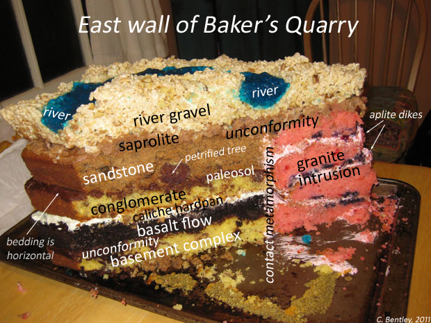
(Source: Callan Bentley, AGU Blogs. For a detailed analysis of this stratigraphy, click here).
Formations and Walther’s Principle
As mentioned above, when sediments are deposited into a basin, they are affected and also affect the basin. Where sediments ultimately come to rest is dependent upon the energy level of the system and how it is able to handle sediment grain size. Generally, the energy level of water moving sediment decreases as gradient shallows, from mountains to the sea, gradually leaving behind successively smaller particles. Beaches, locations many of us are very familiar with, are full of sand because the energy levels at the seashore are well-suited to that grain size. In deeper water, grain sizes diminish even more, until all you find are marine muds well offshore. These successive sedimentological changes, along with the flora and fauna adapted to living in them and the unique structures created are how we determine local facies. The facies are the characteristics of a rock, formed under its unique depositional environment. Along a seashore, sedimentary facies will display a gradual decrease in grain size from areas well above the tidal zone (supratidal) to areas well below wave base (deep marine).
In these seashore locations, one of the key variables that affects how strata develop through facies are changes in sea level. Sea level change is continuous. Sediment deposition along shorelines is also continuous during these changes in sea level. When sea level rises, we call it a transgression. When it falls, we call it a regression. As water level rises, or transgresses, something interesting happens. These facies migrate shoreward also! Likewise, as water level drops, or regresses, the facies migrate seaward. Named after German geologist Johannes Walther as “Walther’s Principle”, these ideas describe how changes in sea level lead to changes in stratigraphic “stacking” of strata, or sequences.
Please watch this video below for an excellent explanation.
As seen in the video above, Walther’s Principle applies to both siliciclastic basins and carbonate basins. In siliciclastic basins, our shoreward to deep marine progression might begin with conglomerate and then continue offshore with sandstone, siltstone, and end with mudstone. If sea level rises, deep marine facies will be pushed shoreward and deposited on top of shallower water units in a fining-upward sequence, typically of a transgressive sequence. Likewise, if sea level regresses, shoreward facies will migrate toward the sea, being deposited on top of deeper water facies, creating a stratigraphic succession of coarsening-upward layers.
In carbonate systems, the shoreward to deep marine sequence runs from grainstone (mostly fossil material) to packstone, wackestone (more mud), and ends with a limey mudstone. The same transgressive and regressive sequencing applies with changes in sea level up and down in these environments.
Packages of stratigraphic sequences can be transgressive or regressive in nature. When a transgressive sequence lies below a regressive sequence, the boundary between them is referred to a as a “Maximum Flooding Surface“. Likewise, the top of a regressive sequence is erosional and referred to as a “Sequence Boundary“.
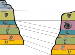
Pattern Matching and Stratigraphic Correlation
Millions of years of weathering and erosion shape our landscapes. Over that time, the records of deposition in ancient basins are washed away, often leaving only sparse remnants of these strata. Measured stratigraphic sections, separated by great distances due to erosion, provide the record necessary to reconstruct these larger ancient environments. The process of connecting layers across these distances is called correlation. Such correlation typically focuses on thicker strata, but can also be done in some cases with microstratigraphic strata, such as minute beds of fossils, volcanic ash beds, impact deposits, etc. Stratigraphic correlation is about making connections. It is a set of scientific activities that seek to match rock patterns across distances.
There are a wide variety of ways that stratigraphic patterns are identified and matched, and quite commonly, the patterns do not match up perfectly. Bedding thickness varies over distances. Beds “pinch out” between outcrops. Sometimes, in some places, a new bed is introduced. Physical or chemical characteristics may be missing. The reasons for these variations are multiple. Simple way to consider these variations is to imagine walking along the coast of eastern North America, and observing the changes you see. While there are many commonalities between the beaches of Florida, Virginia, and New Jersey, changes in the shape of the shoreline, development of large bays, variations in water chemistry, the presence or absence of barrier islands, subtle climate variations, inflowing river channels, the slope of the continental shelf, and a great many other features along a coast will cause shoreline conditions to change. As a result of these natural physical variations, populations of organisms and even entire ecosystems will vary, too. Post-lithification processes can also erase physical and chemical characteristics of the rocks through compaction and diagenesis. All of this natural variation can make correlation quite tricky! Stratigraphers, the geoscientists who study patterns within sedimentary rock layers, have developed a variety of complementary methods that aid in correlation between sites. Ultimately, these tools help establish relative age connections between distant units sometimes separated by millions of years of erosion, tectonic uplift and change, and other geological processes.
Dual GigaPans of Tonoloway Formation along Corridor H. You are seeing two sides of the highway at the same location. Click on the title of the Gigapan and then make it full screen so that you can play with the images. How would you go about correlating these layers from one side to the other? For what distinctive features might you look? List some in the quiz below.
Dueling Tonoloway Outcrops
Patterns that emerge from measured stratigraphic sections represent not only environmental changes on various scales, but also record the local interactions with the biosphere, atmosphere, hydrosphere, and even with the exosphere, the space environment. If stratigraphy is a record of events in a basin over time, then it will be recorded in complex ways due to these interactions between systems. There will be a record of climate change and large-scale weather events, biosphere events, evolutionary change, changes in the Earth’s magnetic field, and astronomical events that leave an impact (pun intended!). Such changes will often be global and regional in nature and occur across different environments, requiring an analysis focused on events in time across a region. Over the years, stratigraphers have developed various subfields to help provide focused study in these areas. These subfields of stratigraphy include chronostratigraphy, lithostratigraphy, biostratigraphy, and magnetostratigraphy. Together, these fields provide tools that allow the piecing together of the geological past.
Lithostratigraphy
The name, lithostratigraphy, comes from the Greek words lithos, meaning rock, and strata, meaning layers. So lithostratigraphy is the study of rock layers. In lithostratigraphy, we are very interested in the sediment grains that make up these layers. We want to know their mineral composition. We want to examine their shape, whether they are rounded or not. We also want to know something about their sorting, whether they contain a diverse mix of grain sizes or just one grain size. These pieces of evidence describe, in part, the “facies” of the rock,which allows scientists to determine how the rock was formed and where it might have originated. In a stratigraphic section, stacked strata will often come vary from bottom to top, indicating a detailed record of environmental change. This record provides a history of the sediment deposition in that basin, changes in sea level, and can also provide important insights into climate fluctuations, all at a variety of time scales.
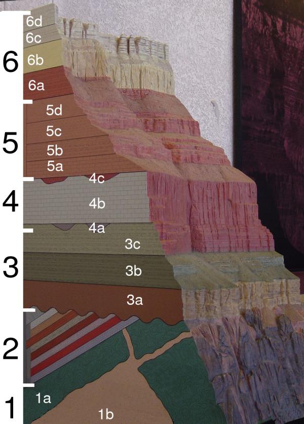
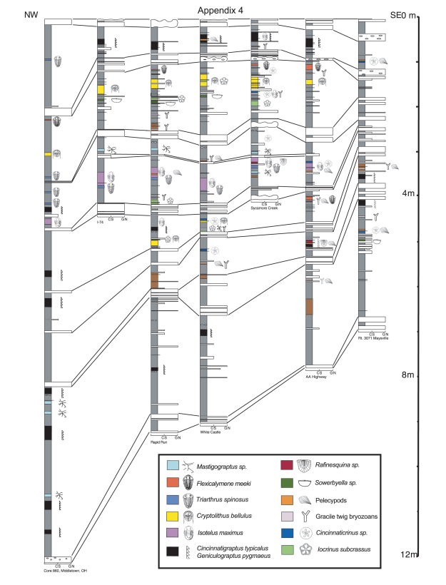
In lithostratigraphy, rock strata are placed in a hierarchy based upon several factors. Key among these is their lateral regional extent. The basic lithostratigraphic unit is called the formation. In order to be given this designation, a layer of rock must be mappable across an area. It must bear the very similar characteristics when seen in locations across that area,and have similar, distinct boundaries, or contacts, with layers above and below. Formations are the units used by field geologists when creating geologic maps. Formations also have a “type section” identified that represents the outcrop for which the standard description of the unit was created. They also have contacts with formations above and below, which are also mappable. Within formations, samller subunits called members can be identified. A member is a lithologically distinct bed within the larger formation. In stratigraphic columns below, the Kope Formation is divided into several members. And, within these members, beds are often discernable. The type Cincinnatian is an ideal section for the study of individual beds, as they are often laterally extensive and therefore traceable across the region. A single limestone bed, such as those numbered as 25-31 in column C below, mark distinct moments in time across the region. If enough stratigraphic sections exist from across a region, further patterns will emerge. Roadcuts, cliff faces, and other locations are ideal study areas. Individual rock layers may or may not be present in all of these. They may vary in thickness and content. But this information can help reconstruct the history of not just a single location, as represented by one section, but an entire region.
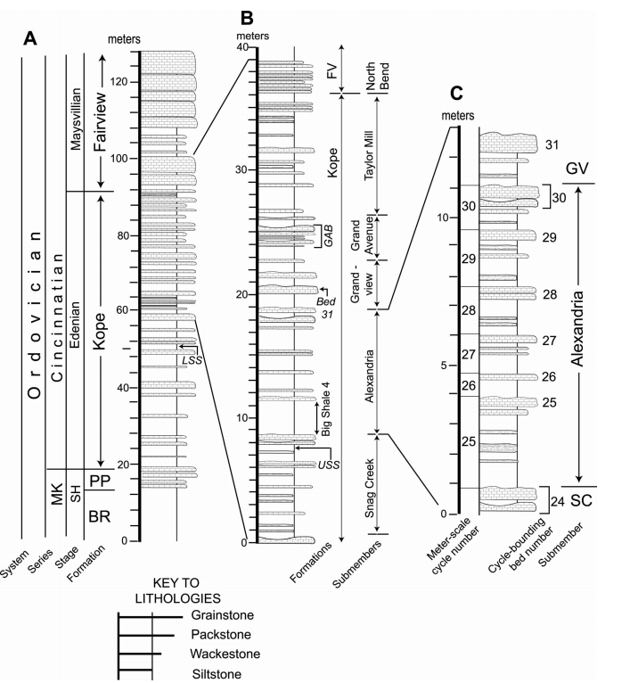
(Adapted and used with permission: Kirchner and Brett, 2008).
Normal Fault in Chalk – Correlation of both sides of the fault. Try to match the two sides up be moving the gigapan images around. Can you get ride of one of the faults? If so, you just correlated layers!
Lithostratigraphic Hierarchy
Flow (if volcanic materials are included) → Bed → Member → Formation (Basic Lithostratigraphic Unit) → Group → Supergroup
Packages of formations can be put together into groups. Packages of groups can be assembled into supergroups. Such higher designations are not always necessary or ideal, but in situations where the rock formations are closely related, their use makes good sense. The Grand Canyon Supergroup and the Belt Supergroup are two well known American examples of this largest designation.
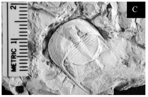
Fossils as Stratigraphic Tools: Biostratigraphy
(By דקי – אני יצרתי, CC BY-SA 3.0, https://commons.wikimedia.org/w/index.php?curid=17935309)
Biostratigraphy is a set of tools used to correlate patterns and beds using fossils. Fossils come in a variety of forms, either as body fossils, such as skeletal parts or impressions, or trace fossils, evidence of movement or activity. Usually, this information is collected in addition to the lithostratigraphic information. Biostratigraphic designations are based upon the existence of a particular diagnostic feature within strata specific to fossil material. Sometimes, such fossil material can be traced over great distances, much like lithostratigraphic layers (Kohrs and Brett, 2008). Biostratigraphic units can vary across a location and so such tracing of fossil beds is not necessarily a basic goal of biostratigraphy. Communities within an ecosystem vary across an environment, depending upon physical and biological conditions. Water depth, temperature, salinity and currents, along with sedimentation rates and nutrient levels can cause the distribution of particular organisms to be quite spotty. However, some fossils are more ubiquitous, for instance due to planktonic life habits, and so are found more commonly over larger areas as they are spread by currents. Because of all of this variation, while biostratigraphic designations can be used to correlate beds, they are also very important tools for understanding the paleoecological history of a location.
Index Fossils
(Source: USGS)
Across basins or even within a basin, fossil assemblages can vary a great deal. Consider a modern oceanic shoreline, even one with a barrier island system like the Outer Banks of North Carolina. In such areas, there are species that live across facies, and species whose lives are spent entirely within more restricted zones. Species with a broader distribution, that are plentiful, and that fossilize well can serve very well as markers for important intervals. Ideally, the organism’s existence is short-lived. If all of these criteria are met, then that fossil can serve as a marker in strata, an index fossil. Some excellent examples of index fossils can be found here.
Biozones
Biostratigraphy comes with its own unique set of terminology. Unlike chronostratigraphy and lithostratigraphy, there is no hierarchical system of designations. The biozone is the basic element. Biozones are defined by the basic characteristics of their fossil taxa. There are five kinds of biozones. These include range zones, interval zones, assemblage zones, abundance zones, and lineage zones. Due to the lack of hierarchy, and the variety of ways biostratigraphic designations can be made (by single fossils or multiple fossils present), it is possible to have overlapping biozones within a single rock unit.
(Kohrs, 2003).
Range zones come in two varieties. The first, a taxon-range zone, is defined as a body of strata with a geographically and temporally defined occurrence of a single fossil taxon. The geographic range can be narrow or very broad, but is defined by the entire known set of occurrences of that taxon across the basin or set of basins where it has been identified. The second, concurrent-range zones, are only different from the taxon-range zone in that they consist of overlapping ranges of at least two taxa. Range zones can be used for stratigraphic correlation across locations, due to their geographic extent.
Interval zones are the fossiliferous strata that exist between two defined stratigraphic horizons. These are sometimes referred to as range zones. For instance, you will not find fossils of modern humans going back more than at most 350,000 years. The interval zone of our species only represents the last 350,000 years. Interval zones are bounded by the occurrence of the taxon in question, so do not necessarily have a correlative power. However, because they are defined by lower and upper horizons, these horizons can be used as stratigraphic correlation markers.
Lineage zones are defined by their evolutionary importance. They are zones that contain a particular evolutionary branch of a taxon. These very specific biohorizons, again defined by their lower and upper limits of occurrence, are very reliable means of relative time correlation in biostratigraphy. It is one thing to be able to correlate across a region the existence of a particular family or genus of a brachiopod, but quite another to be able to define a correlatable time horizon using a specific species.
Assemblage zones are defined by the lower and upper boundaries of strata that are defined by the presence of three or more fossil taxa. These taxa may represent members of a community within the paleoenvironment defined by the strata in which they are contained. Across a region, not all members of the assemblage need be present to be defined in this way, but most of them should. Individual taxa can also have more extended ranges above and below the assemblage zone.
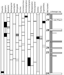
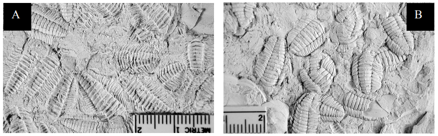
Abundance zones represent a body of strata where the abundance of a particular taxa is significantly greater than usual. The Triarthrus eatoni zones in the figure below from Kohrs (2008) can be defined as abundance zones within the context of a single location, though such zones are potentially also correlative tools. This trilobite can be found here and there within the Kope Formation, but at each one of these localities, could be found in unusual abundance and preservation as a fossil lagerstätte. As correlative markers, they mark a particular useful biohorizon.
(Kohrs and Brett, 2008).
Abundance Zones or Lack Thereof: Fossil Lagerstätten, Epiboles, and Outages
(Kohrs and Brett, 2008).
Some fossils are exceptional in how they are preserved. Exceptionally rich fossil deposits are given the name lagerstätten, a German term that literally means “storage place” because the preservation is so exquisite as to represent what the original organism was like in appearance. Such fossils can sometimes be found in beds that are traceable as units across a region, their exception preservation being caused by the rapid deposition of sediment downslope during a storm event or by some other means. As such, they can be used as important biostratigraphic marker beds (Brett and Baird, 1997).
(Kohrs and Brett, 2008).
In general, beds that are stratigraphically traceable across a region may contain fossils that appear in one place but not in another. Fossils are suddenly very abundant in bed or formation may represent what is referred to as an epibole, or a sudden flourishing of a species or community in the stratigraphic record. These can at times be important event beds for correlation across a region. Likewise, the opposite of this is an outage, which represents the disappearance of a fossil or community. This could even be a localized extinction event (e.g., Brett and Baird, 1997). Again, such outages can be important biostratigraphic event be markers.
Principle of Faunal Succession
Because of the way evolution has influenced life on Earth, there is a distinct sequence of appearances of organisms through time. This sequence of life begins four billion years ago, with the appearance of single-celled prokaryotic microbes. Since then, origination and extinction have formed and killed off numerous species, always giving way to new species with novel adaptations based upon shared and derived characteristics. Important patterns develop across the fossil record that allow paleontologists to identify rock units as being of a certain age or environment. It is known, for instance, that humans never lived with dinosaurs. Human fossils have never been found with, among, or in units with dinosaur fossils, and these groups of fossils are separated by at least 61 million years of time, sediment, and events. If a rock contains a dinosaur fossil, we can thus tell that it is at least 65 million years old but not more than 243 Ma (Nyasasaurus parringtoni). If it contains a human fossil, our species specifically, it is likely less than 500,000 years old.
Chronostratigraphy
Some sediments are deposited at the same time within a basin, but within different depositional environments. Likewise, at any given point in geologic time, multiple basins around the planet accumulate sediments depending on regional tectonic and climatic conditions. Chronostratigraphy, or stratigraphy based upon time, provides a way to correlate units that would otherwise seem to be unrelated. Chronostratigraphy uses aspects of biostratigraphy and numerical dating to constrain the time of deposition within basins using notable fossil beds and other unique features, like volcanic ash deposits.
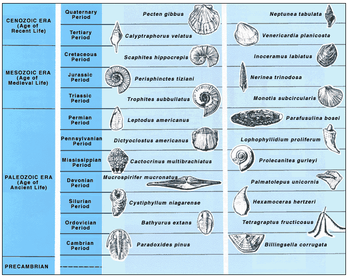
Chronostratigraphy places strata in a hierarchy based upon radiometric dates calculated from sampling minerals in a rock, rather than relying solely on physical features in the rock. Common examples of such markers are volcanic ash layers, magmatic intrusions, and zircon crystal inclusions. Globally, the International Commission on Stratigraphy (ICS) has created a time chart based upon an agreed global chronostratigraphy. Each boundary on this time chart is marked by a GSSP, or Global Stratotype Section and Point. A GSSP is a chronostratigraphic “type locality” where that boundary has been marked as the example for entire geological community. Global chronostratigraphic names can be different than regional names for these periods of time. There is a long tradition of applying regional names to rock and time units in the geosciences. Many of the names on the geologic time scale, such as Cambrian and Devonian are derived from locations in Europe. Sometimes, old regional names fall away in favor of others. Among scientists, more regionalized names become a part of the common geological vernacular, where there may be much less familiarity with global designations. For example, the Cincinnatian Series is the local name in the eastern United States for the global Upper Ordovician Series.
Chronostratigraphic designations are roughly equivalent to their lithological counterparts. What follows is a table showing the various lithologic units with their chronostratigraphic equivalents.
Comparison of Chronostratigraphic and Lithostratigraphic Designations
| How to Name Our Moment in Geologic Time: Lithostratigraphically and Chronostratigraphically | Lithostratigraphic Designation | Chronostratigraphic Designation |
|---|---|---|
| Phanerozoic | Phanerozoic Eon | Phanerozoic Eonothem |
| Cenozoic | Cenozoic Era | Cenozoic Erathem |
| Neogene | Neogene Period | Neogene System |
| Holocene | Holocene Epoch | Holocene Series |
| Meghalayan | Meghalayan Age | Meghalayan Stage |
Chronostratigraphic designations and boundaries are marked with radiometric dates. For the GSSPs that do exist, the dates are accompanied by a feature in the rock, such as a fossil zone, magnetic horizon, or other distinctive feature found widely at that time. This combination of factors can be hard to find. Because of this, not all boundaries on the ICS timescale have agreed upon GSSPs. Sometimes, the term “Golden Spike” is used to refer to GSSPs.
“Golden Spikes”
On May 10th, 1869, politician Leland Stanford drove a 17.7 karat copper-alloyed “golden spike” into a wooden railroad tie at Promontory Summit, Utah. At this location, the Union Pacific and Central Pacific railroad lines connected their respective ends of the transcontinental railroad, ending many years of labor and connecting a nation just beginning the long recovery from a civil war. The term “golden spikes” is now used to mark moments of geological importance where significant changes, or shifts, occurred.
Geologically, a “golden spike” is used to mark a boundary on the geologic time scale (note the “golden spikes” on the ICS timetable linked above). “Golden Spike” is a colloquial term used for the more technical Global Boundary Stratotype Section and Point, or GSSPs, that are used to define most boundaries on the geologic time scale. There are rules for marking these, and they are as follows:
- A GSSP has to define the lower boundary of a geologic stage (body of rock deposited during an Age).
The lower boundary has to be defined using a primary marker (usually first appearance datum of a fossil species). - There should also be secondary markers (other fossils, chemical isotope signatures, geomagnetic reversal).
- The horizon in which the marker appears should have minerals that can be radiometrically dated.
- The marker has to have regional and global correlation in outcrops of the same age
- The marker should be independent of facies.
- The outcrop has to have an adequate thickness
- Sedimentation has to be continuous without any changes in facies
- The outcrop should be unaffected by tectonic and sedimentary movements, and metamorphism
- The outcrop has to be accessible to research and free to access. This includes that the outcrop has to be located where it can be visited quickly (International airport and good roads), has to be kept in good condition (Ideally a national reserve), in accessible terrain, extensive enough to allow repeated sampling and open to researchers of all nationalities.
GSSP markers provide geoscientists with a common language globally. They also provide common markers that are used to mark boundaries on the geologic time scale. In science, it is important to have a common language that everyone can use for efficient and clear communication. In the story of the rock record, it is important to identify important highlights. While the determination and description of a GSSP is not a flashy act, these markers are used throughout the discipline in a variety of important ways. “End-Permian” is used to discuss a very large mass extinction. “Frasnian-Fammenian”, two stages at the end of the Devonian, is used to discuss that extinction.
Magnetostratigraphy
Like other stratigraphic tools, magnetostratigraphy relies on special properties in the rocks to correlate them across distances. In the case of magnetostratigraphy, the record examined is the recorded inclination and declination of the Earth’s magnetic field at the time of deposition, also known as normal and reverse polarity. This includes correlating times of magnetic reversal, or times when the Earth’s magnetic poles have reversed polarity, with “Geographic South” becoming “Magnetic North”, and vice versa. Operating irrespective of the lithology or fossil content, magnetostratigraphy relies on minerals in the sediment at the time of deposition or in volcanic ash deposited during eruptions, allowing a different set of correlations to be applied.
Magnetostratigraphic “zones”, or magnetozones, are portions of the stratigraphic section that share polarity from the same time period and, within these zones, “magnetic chrons” can sometimes be identified that allow numerical dating of specific moments within such zones. Such zones and chrons, when traceable over distances, contribute unique information about a time period in that location and region, but also complement the tools offered by chronostratigraphy, lithostratigraphy, and biostratigraphy in characterizing the rock record or by filling in knowledge gaps left by them.
Many important GSSPs are marked by magnetozone boundaries. All of the important ratified GSSP boundary markers for the Pleistocene Series of the Quaternary System (1.8ma and 2.58ma) and the Pliocene Series of the Neogene System (3.6 Ma and 5.33 Ma) are marked by magnetic polarity changes in the stratigraphic record. These boundaries mark global changes in the Earth’s magnetic field polarity as seen in iron-bearing minerals. For example, the GSSP for the Gelasian Stage of the Pleistocene marks the end of the Pliocene and the start of the Pleistocene System. This magnetic boundary is described at an outcrop in Calabria, Italy, located just off of the main road near an old farm. In this bucolic setting and contained within the limey muds of the unit, lies a magnetic anomaly that marks an important reversal of the Earth’s magnetic field. You could sample this rock and never see it, as such a boundary is not visible to the eye, but only through a magnetometer. Still, this reversal should be recorded globally and represents an important boundary between two stratigraphic units.
Measuring Stratigraphic Sections
In order to use stratigraphic tools provided by lithostratigraphy, biostratigraphy, etc., sections of strata have to be measured. This critical work is done primarily in the field. The stratigrapher plans a field outing, beginning with researching relevant background information collected from geologic maps of an area academic and state geologic survey publications. Direct exploration of brand new stratigraphic sections created by human or natural processes, such as cuts in a hillside for new roads or new stream cuts caused by flooding, are also excellent means to examine strata. Once the preliminary library or fieldwork is done, detailed fieldwork can begin. This includes measuring sections, photography, sample collection, and sketching. Sometimes, sections are measured at a meter-scale, sometimes at a centimeter-scale or finer, depending on the research questions being considered. Data is recorded at intervals, relative to a known datum and a detailed stratigraphy will emerge through the drawing of stratigraphic columns. However the measurements are taken, using consistent techniques from one site to the next is critical toward providing a solid stratigraphic model that is useful for drawing conclusions about the data and for generating predictions to be tested.
Measuring sections on multiple scales can be very important. At the time of deposition, sedimentary units are much thicker than they are once millions of years of compaction and lithification have taken place. Sedimentation rates can vary over time and compaction is one secondary effect that begins to remove some of the original information from a particular page in the stratigraphic record. While the original thickness of the unit can be a matter of some speculation, it is usually possible to produce a good estimate. This can give us an idea of the rate of erosion, climate, and other factors working at the time of deposition. Because compaction also leads to burial and, with burial, heating, we can obtain information about these secondary processes from fossils and other sedimentological evidence.
The analysis of fine layering within a unit of rock or entire stratigraphic column can be described as microstratigraphy. At these scales of analysis, from sub-millimeter to perhaps up to a meter of scale, it is possible to describe environmental events and processes occurring within rather small time scales. The Tonoloway Formation of West Virginia preserves packages of alternating gypsum crusts resulting from periodic evaporation events. While we cannot be absolutely certain about the timescales involved with each layer of limestone and gypsum crust, we can surmise that it is possible that such deposition represents time intervals of days to years, or perhaps seasonal changes over the course of a single year. Other microstratigraphic evidence could help constrain this further.
Microstratigraphic record of Silurian tidal flat carbonates, including salt casts, in the Tonoloway Formation, West Virginia. What can we learn from such fine layering? What can we read from the packages of sediment here that are no more than 2-3mm thick after compaction and lithification?
Studying stratigraphic layering is most often done at a larger scale, by describing strata on the order of decimeters on up to perhaps thousands of meters. These larger patterns of deposition can represent a few million to tens of millions of years. Providing a broader, larger, view of events occurring within a basin over larger spans of time allows for a deeper understanding of the behavior of the basin as a whole. These behaviors would include being able to study the tectonic processes occurring or major changes of sea level at a variety of scales. As space in a basin fluctuates and, eventually, a basin infills, this large-scale record provides the story of how deposition took place. Just as important, this story provides direct evidence for developing models of tectonic change for mountain belts, changes in paleogeography, or changes in ancient climates.
A larger stratigraphic record of the Devonian Foreknobs Formation in West Virginia, along Corridor H. This roadcut, created by the human activity of building a road, documents just one section of this formation and its alternating sequences of sandstone, siltstone, and shale.
Stratigraphy is not just an Earth Thing…
Even on Mars, robots take pictures and measure crater stratigraphy! As human and robotic exploration push further out into our planet’s solar system, we are increasingly finding application for stratigraphic principles outside of Earth. On Mars, one of the places in our solar system where might likely be found one day, the search for water, past or present, has always been important. In recent years, evidence of water has been found in phyllosilicate (clay mineral) layers in crater walls in places like Gale Crater. While the mere presence of water does not in itself indicate that life was ever present, it does help round out the requirements. From a stratigraphic point of view, the presence of water means that sediment was washed from highlands into a basin via streams.
“Shaler” outcrop at Gale Crater on Mars, taken on Sol 0309, Mars Science Laboratory (Curiosity). This outcrop contains shale deposits in a very typical layered strata, possibly representing an ancient lake bed. These can be measured on different scales. Near the top of the outcrop, a darker colored rock appears, perhaps basalt from a lava flow.
There is little doubt that the principles of stratigraphy tha we have found so useful and informative on Earth will cease to continue to reveal new insights into our own planet’s past. But, as we dive more deeply into the geologic history of places like Mars, what will stratigraphy’s insights have to say that help tell the unique story of that planet and various locations on it?
Further reading
Kirchner and Brett (2008). Subsurface Correlation and Paleogeography of a Mixed Siliciclastic-Carbonate Unit Using Distinctive Faunal Horizons: Toward a New Methodology. Palaios 23(3).
Brett, C. E. & Baird, G. C. (eds) (1997). Paleontological Events. Stratigraphic, Ecological, and Evolutionary Implications. xvii + 604 pp. New York: Columbia University Press.
Kohrs, Russell H. and Carlton Brett (2008). Paleontological event beds from the Upper Ordovician Kope Formation of Ohio and northern Kentucky and the promise of high-resolution event stratigraphy. Cincinnati Museum Center Scientific Contributions Number 2.
Cutler, Alan (2003). The Seashell on the Mountaintop: A Story of Science, Sainthood, and the Humble Genius Who Discovered a New History of the Earth. [a biography of Nicholas Steno] William Heinemann Ltd. 208 pages.
Chapter Contents
- 1 Stratigraphy
- 2 The Story of Basins Past, Present, and Future
- 3 Basins, Sea Level, and Accommodation Space
- 4 Basic Principles of Stratigraphy
- 5 Pattern Matching and Stratigraphic Correlation
- 6 Measuring Stratigraphic Sections
- 7 Stratigraphy is not just an Earth Thing…
- 8 Further reading