Geologic virtual field experience to Glacier National Park, Montana:
-
- Overview
- Stratigraphy
- Structural geology (this page)
- Glacial geomorphology
Structural signatures of the Sevier Orogeny
In addition to the sweeping cliffs and brilliant colors of Glacier, there is also a profound story of mountain-building recorded in the rocks of the park. The mountains of Glacier formed during the late Mesozoic and early Cenozoic due to the Sevier Orogeny. This episode of mountain-building shoved older Belt rocks and Mississippian carbonates atop Cretaceous siliciclastic strata in an impressive inversion of their original stratigraphic order.
Tectonic context
The Northern Rocky Mountains of Montana were impacted by mountain-building processes during the Cretaceous. The Sevier Orogeny shoved stacks of sedimentary rocks (including Mesoproterozoic Belt strata, Mississippian carbonates, and Cretaceous siliciclastics) from their original positions deep in the crust and further to the west to new positions, upward and to the east. These displaced layers of rock arched upward and broke, with the slabs of older rock traveling along thrust faults up on top of younger rocks.
The cause of the Sevier Orogeny was the accretion of numerous terranes from the ancient Pacific Ocean, brought eastward as the Farallon Plate subducted beneath the North American Plate. The Farallon Plate used to exist between the Pacific Plate and the North American Plate. The Farrallon’s western boundary with the Pacific Plate was divergent: it was a spreading center (an oceanic ridge). The Farallon’s eastern boundary (with the North American Plate) was convergent: a subduction zone. There, the Farallon was recycled into the mantle. Any island arcs, microcontinents, or oceanic plateaux it was carrying were too thick, buoyant, or protruding to subduct. When they reached the subduction zone, these “terranes” were scraped off and pushed onto and into the North American continent. As they were pushed eastward, they acted like a bulldozer, scraping and shoving the sedimentary rocks that were layered atop the continental crust.
Consider the nascent mountain-building evident in western North America in this paleogeographic depiction from 105 Ma:
Those mountains were driven by compression from the west. As new terranes accreted to the continent, they pushed the pre-existing sedimentary layers out of the way, so that direction was to the east. This process initiated during the Jurassic period of geologic time, but reached its zenith during the Cretaceous. Most of the Farallon Plate was recycled during that time, but two remnants persist into the present day: the Cocos Plate, currently being subducted beneath Central America, and the Juan de Fuca Plate, currently being subducted beneath the Pacific Northwest states of Washington, Oregon, and northern California.
Did I get it?
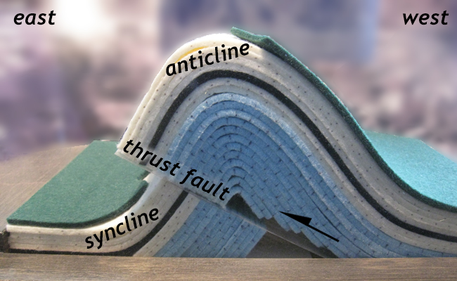
When the sedimentary layers of western Montana were compressed, they buckled and broke, shearing to the east as they deformed. The result was an immense number of asymmetric folds with the short limb on the east and the long limb on the west, frequently breaking at the hinge of the fold, and initiating a fault. These distinctive structures are the typical “structural ingredient” in compressional mountain belts around the world, and they are on great display in the region around Glacier National Park.
An illuminating outcrop on the north side of the Going-to-the-Sun Road shows this structure in three dimensions:
It shows quartzite and red argillite of the Grinnell Formation, with prominent ripple marks on the upper surface of the bed, folded and overturned on the leading edge. This asymmetric, recumbent fold is representative of the general shape of the various thrust sheets in the Disturbed Belt. Minor deformation of the same character occurs within the Lewis Thrust sheet, in a variety of orientations.
In general with faults, the footwall rocks are those below the fault, while the rocks above the fault are called the hanging wall. However, additional terminology is used when it comes to thrust faults, with their significant lateral offsets, and their orientations so close to horizontal. The block or slab or rock above the thrust fault is sometimes called a thrust sheet, or by the term nappe.
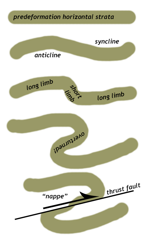
Nappes form when horizontal rock layers are compressed laterally (i.e., from the side) and first buckle into asymmetric folds. The short “limb” of these anticlines and synclines forms in the transport direction (the direction toward which the strata are being thrust). Frequently, this short limb rotates back on itself and becomes tectonically inverted. It also frequently is the place where the strata rupture, and a new thrust fault initiates. Once the mechanical discontinuity of the fault exists, it’s the “weakest link,” and further deformation is accommodated mainly through sliding along that fault surface, not additional folding. Eventually, the fault stops moving, and a new fault forms “outboard” of the first (i.e., further away from the source of the compression). In the case of the Sawtooth Range at Sun River Canyon and Swift Dam, this “more outboard” direction is to the east.
As deformation proceeds, the older thrust sheets get shoved backward and out of the way as new thrusts form beneath them, rising up to the surface. The result is that the older, more western thrust sheets get rotated to steeper dip angles as deformation proceeds. This whole “stack” of nappes is said to be “shingled,” or “imbricated.”
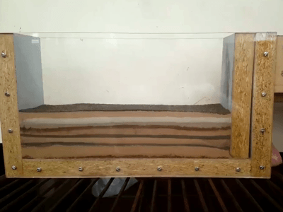
Watch the animated GIF here of a sandbox deformation experiment to get a better sense of this process. It’s useful to watch it many times, focusing on a different region each time and watching how it changes with increasing deformation. Imagine that the perspective here is the same as you would see if you were (a) able to go back in time and (b) hover above the crust north of the Sawtooth Range, looking south, and (c) watch geological processes happen at much faster rates than they really do, and (d) had a magical pair of X-ray glasses that allowed you to peer into the Earth and see these complicated 3D structures evolve in a 2D cross-section.
Did I get it?
Sevier vs. Laramide deformation
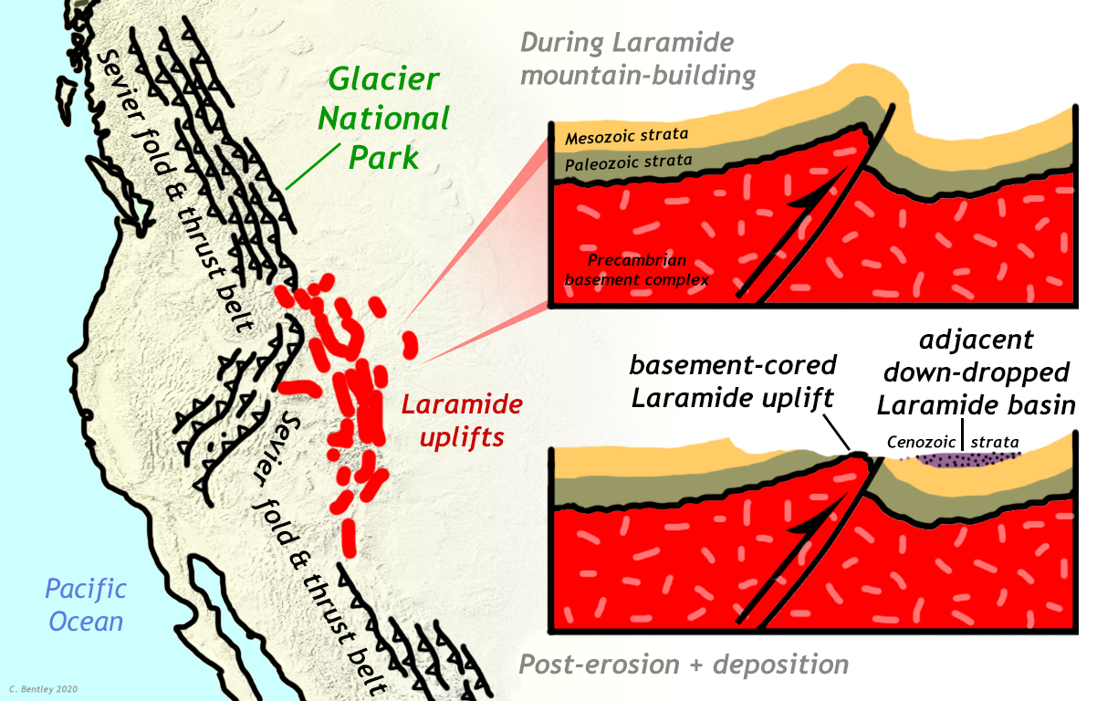
There is another mountain-building event that took place in the Rockies during the late Mesozoic and early Cenozoic, related to but distinct from the Sevier Orogeny. This is the Laramide Orogeny. Ultimately, the Laramide too was caused by the subduction of the Farallon Plate. Compared to the Sevier, however, (1) the deformation style was different, (2) the deformation was more recent, and (3) the deformation took place further to the east. These three variables allow the two orogenies to be distinguished.
Deformation style
The Sevier Orogeny resulted in a classic fold-and-thrust belt of sedimentary layers. This is an example of “thin-skinned deformation,” where the sedimentary cover is deformed, but not the underlying continental crust (the “basement rock” of metamorphic and plutonic rocks). In contrast, the Laramide Orogeny’s style is “thick-skinned,” which is a way of noting that the crustal “basement” is very much involved. Laramide deformation is characterized by very large anticlines and synclines that involve basement rock. The anticlines generated highlands and mountain ranges, which were weathered and eroded. The synclines were so significant that they warped the surface of the Earth, generating lowlands. These sedimentary basins that were filled with huge amounts of cast-off sedimentary detritus from the eroding mountains nearby, making new Cenozoic-aged sedimentary deposits that filled the depressions. In some cases, these young sedimentary layers reach thicknesses of 5000 meters! The economically important coal and natural gas deposits of Wyoming formed in Laramide basins, as did the fossil-rich lake deposits of the Green River Formation.
Timing
Because the Sevier Orogeny was caused by accreting terranes pushing sedimentary layers eastward, out of their way as they collided with the western edge of the continent, it began first. It began in the Jurassic, around 160 Ma, and the last of the thrusting was concluded by around 50 Ma. Because the Laramide Orogeny was driven from beneath, once flat-slab subduction had been achieved, it came later. The onset of Laramide mountain-building was in the late Cretaceous, 80 to 70 Ma, with the episode wrapping up in the window of 55 to 35 Ma. So the two orogenies overlapped in time, but the Sevier started first and ended first.
Location
Laramide deformation is not in the same place as Sevier deformation. Generally, Laramide deformation is further east. The Black Hills of South Dakota, the Bighorn Mountains of Wyoming, and the Colorado Front Range are all examples of basement-cored Laramide deformation. In contrast, the Sevier fold and thrust belt is further west, in a sinuous arc that runs from the Alberta/British Columbia border through western Montana, Wyoming, Utah, and Nevada, and all the way to Chihuahua, Mexico. The Sevier orogen is a much longer feature, too running from Canada through the U.S. to Mexico, while the Laramide uplifts are all clustered in the mountain west of the United States alone.
With these distinctions between Laramide and Sevier deformation now clarified, we will return our attention fully to the Sevier, which is the only orogeny recorded in the structures and strata of the Glacier National Park region.
Did I get it?
Thrust faulting
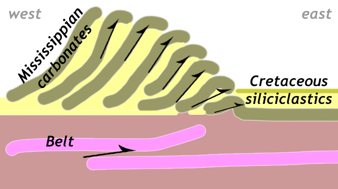
Reverse faults are faults that form in compressional settings, with the fault’s upper block of rock (the “hanging wall”) moving up relative to the lower block of rock (the “footwall”). The motion of the hanging wall over the footwall of a reverse fault creates a repetition of strata in vertical sequence. Thrust faults are reverse faults that dip at a low angle. Some are pretty much horizontal! There are two basic thrust fault varieties in the vicinity of Glacier National Park: (1) an imbricated stack of relatively small thrusts, such as at Sun River Canyon, placing Mississippian carbonates on top of Cretaceous siliciclastics, and (2) large coherent thrust sheets of Belt Rock, again climbing on top of Cretaceous siliciclastics, such as (2a) the Eldorado Thrust at Little Prickly Pear Canyon and (2b) the Lewis Thrust at Glacier National Park itself.
The geologic map below gives some context to these different styles of thrust faulting along the Rocky Mountain front. At Glacier National Park, Belt rock (lavender colored) is thrust atop Cretaceous siliciclastic strata (green) along the Lewis Thrust. Notice how the outcrop pattern of that lavender rock makes a northeastward-directed “bulge.” This is called a “salient.” South of that location, at Sun River Canyon, west of Augusta, the Belt rock is much further west of the mountain front. Instead, at Sun River Canyon (and also at Swift Dam) the leading edge of the fold and thrust belt shows Mississippian carbonates (blue on the map) are thrust atop Cretaceous siliciclastics (green) along dozens and dozens of smaller thrust faults. Further south still, at Little Prickly Pear Canyon, another eastward salient of Belt rock is thrust atop Cretaceous siliciclastics along the Eldorado Thrust.
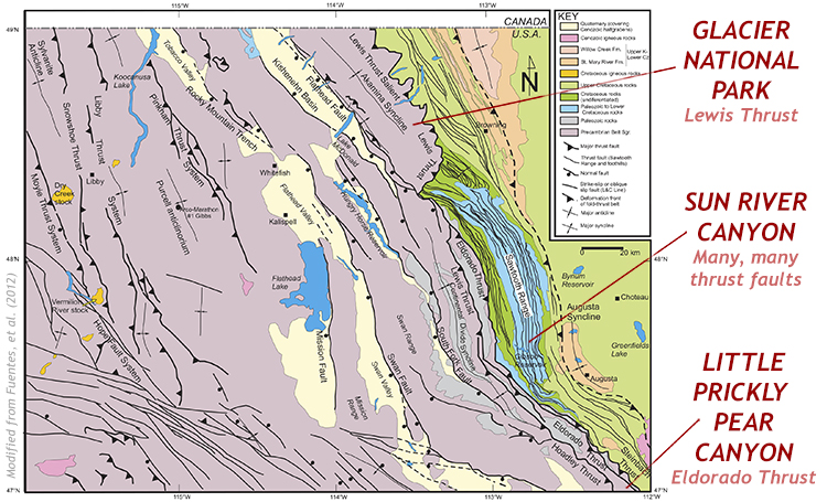
Where the Mississippian carbonates appear, they appear between the Belt rock and the Cretaceous rock, a reflection of their original stratigraphic order. Where the Mississippian carbonates do not appear, the displacement of the Belt rock is greater. Tectonic transport has displaced it further, overriding the Mississippian package completely, and coming to rest atop much younger strata.
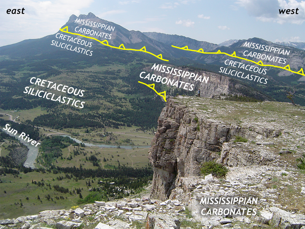
The Disturbed Belt at Sun River Canyon
West of Augusta is Sun River Canyon, a terrific place to view an imbricate stack of thrust faults from the Sevier Orogeny. Collectively, the mountains around Sun River Canyon are called the Sawtooth Range. Let’s begin with a Google Maps overhead view:
Each of the north-south-trending white stripes in that Google Map are mountain ridges that are held up by Mississippian carbonates. In between each of them, the dark green valleys are floored by Cretaceous shales and sandstones. The plains at the right (east) side of the map are also Cretaceous siliciclastic sediments from Western Interior Seaway.
In this geologic map, showing roughly the same field of view, the Mississippian-aged carbonate rocks are shown in blue and purple colors, while the Cretaceous siliciclastics are shown in green and brown. Separating them (and oftentimes within them, too!) are thrust faults, marked as black lines with triangular “sawteeth” coming off them to the west (the hanging wall side of the fault):
In cross-section, east-west along the line of Sun River’s course, we can see dozens of undulating west-dipping thrust sheets, with the blue/purple Mississippian carbonates underlying the many mountain ridges and green/brown Cretaceous siliciclastic strata cropping out in the intervening valleys (colloquially called “gulches” here):
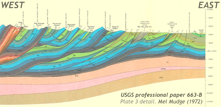
One thing that should jump out at your eye from this map and cross-section is that the strike of the strata and the trace of the faults are parallel. This tells us that the sedimentary layers themselves are controlling the style of deformation: strong, stiff layers are riding up atop weak, pliable layers. The tectonic compression is “accommodated” by displacement mainly along weak shale layers. The over-riding slabs of stiff rock are the layers of Mississippian carbonates.
Structural geologists who have mapped these rocks along a 145-km-long transect across the mountain front have estimated that these rocks experienced about 135 km of tectonic shortening. In other words, the stack of sedimentary layers (Belt, Mississippian, & Cretaceous) has been horizontally compressed 135 kilometers east to west. This has resulted in vertical thickening, mainly via thrust faulting and stacking of stiff layers atop weak layers. That tectonic thickening has built the Rocky Mountain front. The mountain front is so topographically extreme for a related reason: Not only are the Mississippian carbonates stronger than the Cretaceous siliciclastics, they are also more stable in terms of weathering. They stand up tough to mechanical weathering and chemical weathering and erosion, and so form topographic “highs,” resistant features in the landscape. In contrast, the Cretaceous shales and sandstones are readily removed by erosion, the shales even more rapidly than the sandstones. These strata form topographic “lows” and gently rolling terrain.
Most shortening in the Lewis Thrust system, Sawtooth Range, and foothills occurred roughly between late Cretaceous and Early Paleogene time (ca. 75–52 Ma), yielding a shortening rate of ∼5.9 mm/yr. Even though these mountains are very impressive today, they grew slowly: your fingernails grow faster than that!
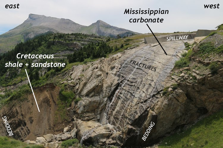
Here is an example of some imbrication in the Cretaceous siliciclastic strata immediately east of the mountain front at Swift Dam. The sandstone layers get repeated along a set of parallel thrust faults:
One of the best places to examine the fault contact between the two different rock units in the Sawtooth Range is where the French Thrust crosses the road in Sun River Canyon. Here is a GigaPan that allows you to explore this contact. At the left (east) is Cretaceous black shale of the Kootenai Formation, and at the right (west) is Mississippian carbonate of the Castle Reef Dolomite.

(It should be noted that although our focus at the moment is on the structural geology of this site, the outcrop above also features two surficial sedimentary deposits: till (from glaciers) and colluvium (from mass movement), both at the left (east) side of the image. Can you tell which is which? Check your answers with this field sketch, drawn on-site last year.)
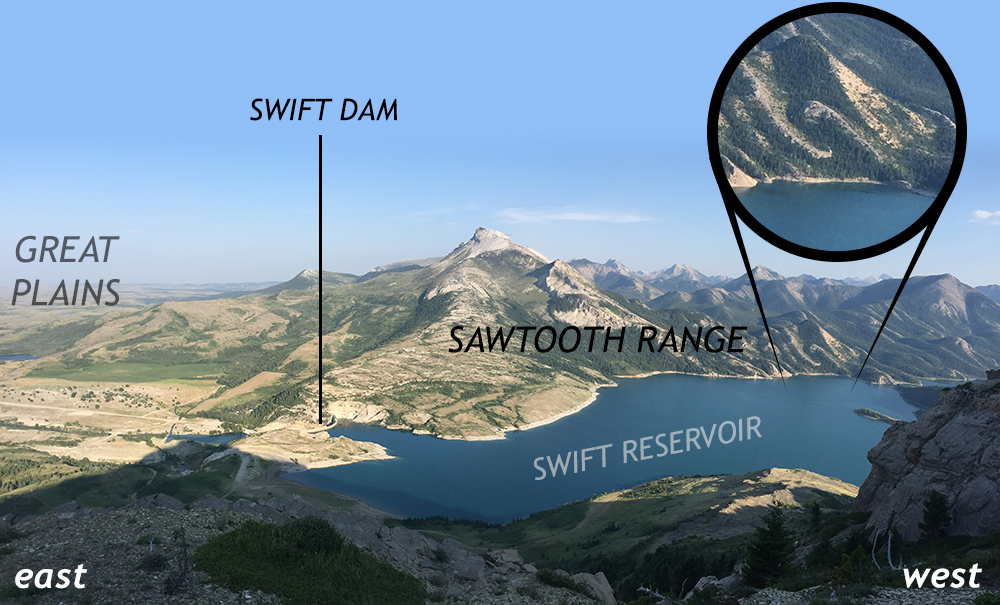
Swift Dam
Swift Dam is a nearby site that adds perspective to this deformation. There, you can see the “nose” (hinge) of the lowermost (newest) anticline bulging out of the mountain front. Cross-sectional views are available both looking north from Swift Dam itself and looking south from near the Swift Reservoir spillway. The spillway actually drains over top of it! The gently curving shape of the overturned anticline is plainly exposed. Additionally, many fractures cross the carbonate rock there (the Castle Reef Dolomite) in an orientation that is parallel to the hinge of the fold. Just to the east of the front of this anticline “nose” are decent exposures of the strata it has ridden over: the Cretaceous-aged shales and sandstones of the Kootenai Formation and the Blackleaf Formation. Let’s look in detail at both sides of this contact:
The weaker siliciclastic strata of the Cretaceous package are intensely sheared and folded on smaller scales. If you climb the dolostone of the Swift Dam spillway and look eastward, this is your view of these sheared footwall sandstone and shale:
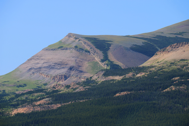
Zooming out a bit shows that, as at Sun River Canyon, there are many fold/fault pairs at Swift Dam. As you head west into the Sawtooth Range, you encounter more of the same, repeated packages of Mississippian carbonates asymmetrically folded and thrust over Cretaceous shale. As at Sun River Canyon, the dip angle of the thrust sheets gets steeper to the west.
Below is a geologic map of the Swift Dam area: Examining it, you can see the lavender Mm (the abbreviation for the Mississippian Madison Group carbonate; specifically the Castle Reef Dolomite) thrust over the olive Kk and light yellow Kb (Cretaceous Kootenai Formation and Blackleaf Formation, respectively). Note the many northwest-southeast trending faults, again with the black triangular “sawteeth” on the west side, indicating (a) that is the hanging wall and the fault dips to the west, meaning (b) that the compressional force came from the west.
The Eldorado Thrust
The Eldorado Thrust is the name for the fault at the leading edge of the southern Belt salient in our region. (The Lewis Thrust is the fault at the leading edge of the northern Belt salient.) Driving Montana 287 (also Interstate 15) through Little Prickly Pear Canyon takes vehicular traffic through the Eldorado thrust sheet between Helena and Wolf Creek.
In this geologic map, of a location just west of Little Prickly Pear Canyon, you can see the Eldorado Thrust prominently labeled, placing Belt rock (pꞒes, the Empire Formation) atop various Cretaceous siliciclastic and volcanic units.
Schmidt, R.G., and Strong, C.P., 1972, Geologic map of the Roberts Mountain quadrangle, Lewis and Clark County, Montana: U.S. Geological Survey, Geologic Quadrangle Map GQ-977, scale 1:24,00. Explore more here.
Driving north from Helena, one crosses a normal fault at the southern end of Little Prickly Pear Canyon, and enters the hanging wall of the Eldorado Thrust, a southern equivalent to the famous Lewis Thrust that underlies Glacier National Park. The whole drive along route 287 through this canyon is spectacular: cliffs of maroons and mint green rise on either side of the road. Check it out in this Google Maps “Streetview,” which you can manipulate and explore:
In places, additional structures can be observed, like smaller-scale faults…
And intrusive dikes:
The Lewis Thrust
This brings us finally to Glacier National Park itself, where the Lewis Thrust has emplaced an even more coherent hanging wall thrust sheet atop a footwall package of sheared-out siliciclastic strata of the Western Interior Seaway. The mountains of the park are the Lewis Range, from which the fault takes its name, and the mountains were so dubbed in honor of Meriwether Lewis, explorer and co-leader of the Corps of Discovery expedition.
Though the Belt sequence is more or less intact throughout Glacier National Park, smaller-scale deformation can be seen, in particular along the eastern edge of the Lewis Thrust sheet. There, recumbent folds and subsidiary faults can be seen.
As at Little Prickly Pear Canyon with the Eldorado Thrust, the principle of superposition has been upended, with Mesoproterozoic Belt strata coming to rest atop much younger Cretaceous aged rock. However, Glacier is much more impressive for the exposed thickness of the Belt rocks in the hanging wall that are exposed, as well as their impressive glacial sculpting, a later modification that is missing at Little Prickly Pear Canyon.
Did I get it?
Klippen
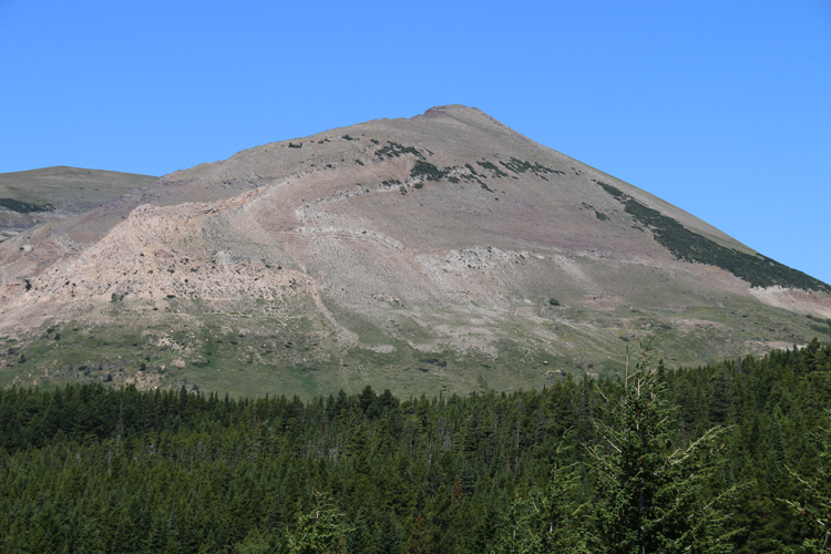
When a thrust sheet such as the Belt rocks above the Lewis Thrust is subject to erosion, sometimes it gets sufficiently chewed away so that only small remnants are left, like “islands” surrounded by the footwall rocks below the thrust. This situation results in a feature called a klippe. If you have more than one, they are klippen, plural.
The classic “textbook” example of a klippe is Chief Mountain, on the park’s northeastern boundary with reservation lands of the Blackfeet tribe:
The rolling, vegetation-covered slopes in the foreground are Cretaceous strata below the Lewis Thrust, mantled with a thin covering of Quaternary-aged landslide deposits. The Lewis Thrust itself is almost perfectly horizontal here, and runs across the base of Chief Mountain, cropping out at the bottom of the cliffs. Above the Lewis Thrust are Mesoproterozoic Belt rocks of the Altyn Formation. There’s actually another ~horizontal thrust running through Chief Mountain, too, about 2/3 of the way up. It can be detected by looking at the change in angle of the Altyn strata within the mountain: horizontal at the top, dipping moderately northward at the bottom.
Here is what that looks like on the geologic map, with Altyn Formation (brown, Ya) sitting atop Cretaceous strata (green, Ku), topped with landslide deposits (orange, Qls).
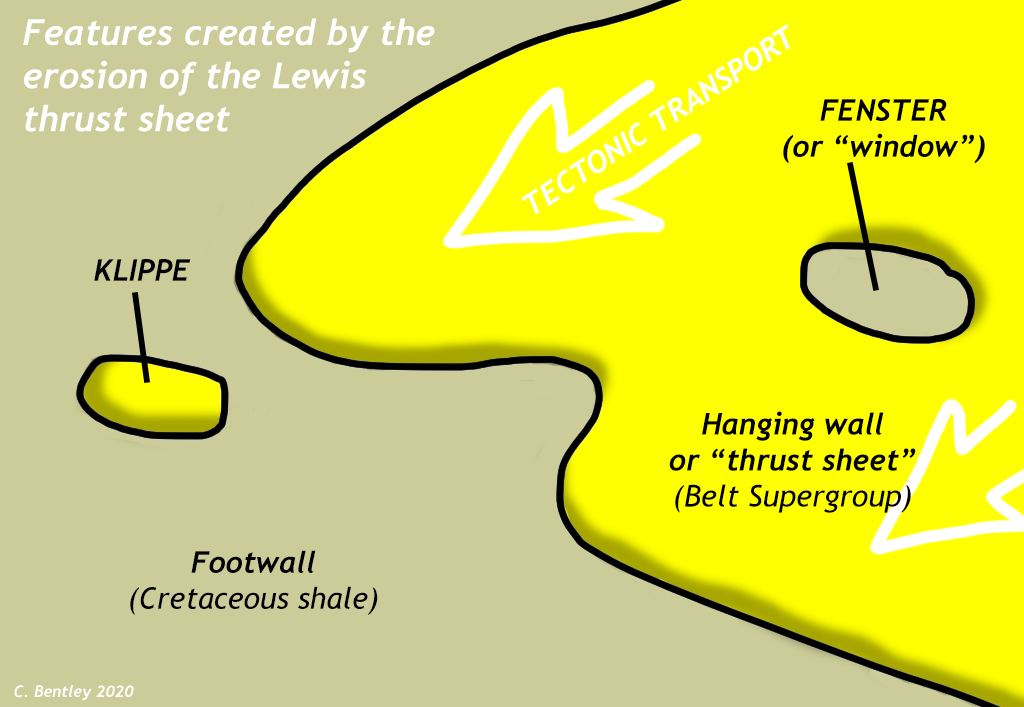
Klippen form when erosion removes the connection between a salient and the rest of the thrust sheet. In the case of Chief Mountain, the erosion was accomplished by glaciers, which flowed here during the Pleistocene, gouging away at the Cretaceous-aged thrust sheet, including its Mesoproterozoic-aged Belt rocks and the Cretaceous siliciclastic strata that comprised the footwall of the fault. It’s also possible for erosion to remove some of the hanging wall rock so a “window” (German: fenster) is opened up, and a small zone of footwall rock peeks out from beneath the thrust sheet. Klippen and fensters are “opposite” features of one another.
Did I get it?
Folding on several scales
Overall, the Belt rocks of Glacier have been folded into a vast trough-like fold, the Akamina Syncline. This results in the overall southwest-to-northeast symmetry of the outcrop pattern across the park: pinks and lavender in the middle, flaked by maroon, then olive green, then pumpkin orange and brown headed out in either direction:
It is a fold with a wavelength of more than 20 km! That’s big.
The axis of that syncline (the line of maximum inflection) passes under some of the tallest peaks in the park, and is highlighted by outcrops of the youngest Belt strata. It is reasonable to infer that this same syncline extends through all the Belt strata down to the Lewis Thrust itself at the bedding-defined base of the hanging wall.
That is the interpretation shown on the Whipple (1992) map, which shows a scoop-shaped profile to the fault, reaching its deepest nadir beneath the axis of the syncline:
Beneath the Lewis Thrust, in the footwall rock, there’s plenty more folding to be observed, but it occurs on much smaller scales: folds with wavelengths of km to m to cm, as the tectonic “banana peel” of shale and sandstone smeared out underneath the massive overriding Lewis Thrust sheet. While the thick stack of burial-metamorphosed Belt rock was stiff and strong, these thinly-layered sandstones and shales were never buried deeply, and are quite weak. As a result, they were pulverized as thrusting brought the Belt rock eastward over their position. Good outcrops showing this deformation can be found along the Looking Glass Highway, north of East Glacier:
Did I get it?
Conclusion
Tectonic compression impacted the sedimentary strata at Glacier National Park during the Cretaceous due to the Sevier Orogeny. The accretion of exotic terranes at a subduction zone far to the west shoved extant rock layers out of the way, piling them up on one another to the east. Older rock, such as Belt Supergroup strata and Mississippian carbonates, climbed atop younger rock, in particular the siliciclastic strata laid down by the Western Interior Seaway during the Cretaceous. The structure of the rock layers changed from a “layer cake” with oldest at the bottom and youngest at the top into a new arrangement dominated by asymmetric folds and thrust faults, with nappes of ancient rock transported eastward and upward by astonishing distances. In places where the Belt rock made it to the surface (Glacier National Park and Little Prickly Pear Canyon), we find more or less coherent thrust sheets, though later erosion has carved klippen out from the leading edge in several places. In places where Mississippian carbonates were instead the rocks on the leading edge (Sun River Canyon and Swift Dam), we instead find a densely-imbricated stack of smaller thrust sheets, older and steeper on the west, and younger and more shallowly dipping on the east.
Further reading
Anne DeVaney (n.d.) “Structural Geology of the Rocky Mountain Front,” Montana Geoheritage Project, hosted on the SERC website.
Facundo Fuentes, Peter Decelles, and Kurt Constenius. (2012). Regional structure and kinematic history of the Cordilleran fold-thrust belt in northwestern Montana, USA. Geosphere 8. p. 1104-1128. 10.1130/GES00773.1.
David R. Lageson (1987). “Structural geology of the Sawtooth Range at Sun River Canyon, Montana Disturbed Belt, Montana,” in Beus, S.S., ed., Centennial Field Guide Volume 2: Rocky Mountain Section, Geological Society of America, p. 37-39.
Omar B. Raup, Robert L. Earhart, James W. Whipple, and Paul E. Carrara (1983). Geology along Going-to-the-Sun Road, Glacier National Park, Montana. Glacier Natural History Association.