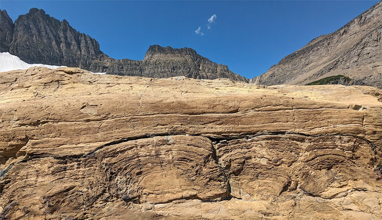
Callan Bentley photo
LEARNING OBJECTIVES
After reading this chapter, students should be able to:
- Understand broad concepts that are incorporated into historical geology
- Recognize the importance of studying historical geology
Who do you know that tells great stories?
A friend, a grandparent, a sibling, a teacher, an author, a director, a singer… Gifted storytellers come in many forms, and tell their tales in many styles.
Now imagine all the stories you have not heard. Imagine the stories you could hear if you could speak every language in the world, and sit across the table from people with fundamentally different experiences, speaking of ancient times and exotic places. Their stories might change the way you look at the world. They might change the way you live your life.
The planet you live on has some stories to tell. Earth has had 4.5 billion years to rack up experiences that range from ordinary to unimaginably violent. Through a variety of rock-forming processes, Earth has written her autobiography. Historical Geology is the science of reading that autobiography. But in order to read it, we first need to understand the language in which it is recorded.
We must learn to “speak Rock.”
Stories from stone
What stories has the Earth written in the language of Rock? Consider this cobble, found in Montana:
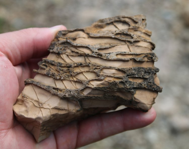
Callan Bentley photo.
This chunk of rock contains features that we can translate into information. The variety of materials it is made from, how those materials are arranged, other features that cut across them, and the shape of the sample all convey information about past processes and circumstances. What would it take to make a rock just like this one? Why does it exist in this particular way?
As an exercise in practicing decoding Rock, let’s translate: The smooth tan material is limestone. It originally formed as inorganic deposits of carbonate mud, laid down (1) in calm water, as evidenced from its very fine grain size. It sat still long enough to stick together into a semi-coherent mass. But then it must have been savagely ripped up to make (2) mud-chip clasts & entombed in (3) quartz sand. The event that was energetic enough to tear into the carbonate mud and rip it up, as well as energetic enough to transport in coarse particles of sand. It must have been a storm, perhaps a hurricane. The threat of more violent storms diminished as the sediment was buried and sank further and further underground, smothered beneath the crushing weight of thousands of feet of sediment piled atop it. Then the carbonate mud chunks and surrounding quartz sand (4) lithified into rock: No longer loose sediment, it was transformed through compaction and cementation into solid, coherent rock: limestone clasts in quartz sandstone. After it was solid rock, it broke. Some stress, perhaps imparted by the wrenching compression of mountain building, snapped the bonds holding the rock together. This made fractures, but those fractures were soon healed by the precipitation of the mineral quartz, making (5) thin quartz veins. This is something that must have taken place deep underground, but in order for us to pick it up and hold it, we know it must thereafter have been (6) uplifted. It made its way back to Earth’s surface, and this particular chunk was broken off from its source outcrop. Finally, it experienced (7) differential weathering, etching away the limestone more readily than the quartz sandstone. This gives the sample its distinctive texture.
The rock is no longer just a rock. By speaking its language, we have turned it into a book, with seven chapters.

Callan Bentley photo.
This is the power of Historical Geology: it allows curious humans to interact with inert rock, and coax stories from that rock — vital tales of the planet’s ancient past. Being able to decode the stories of rocks, hidden in plain sight, is an ability akin to an acquired superpower. As Spiderman gained his powers after being bitten by a radioactive spider, you are about to be bitten by the Historical Geology bug. What you learn will change the way you look at your world.
Like the best stories from our favorite storytellers, what we learn resonates with us, changes us. The Earth’s many tales help us understand our present, live our lives more meaningfully, and prepare for a future we can better comprehend. The perspective granted by speaking Rock helps us live better lives, and look to the future with hope and confidence.
Sequences of strata
Decoding the handful of past processes encoded into a single cobble is powerful, but more power still comes from looking at sedimentary rock in outcrop, and comparing the conditions of one layer with those below it and those above it. The lingua franca of historical geology is sedimentary rock, and vast epic tales have been inscribed in the sequence of accumulated strata, or rock layers.
If a shale means former mud, and that mud’s deposition implies calm, offshore conditions, and sandstone means former sand, and that sand’s deposition implies more energetic, nearshore conditions, then what does this photo show?
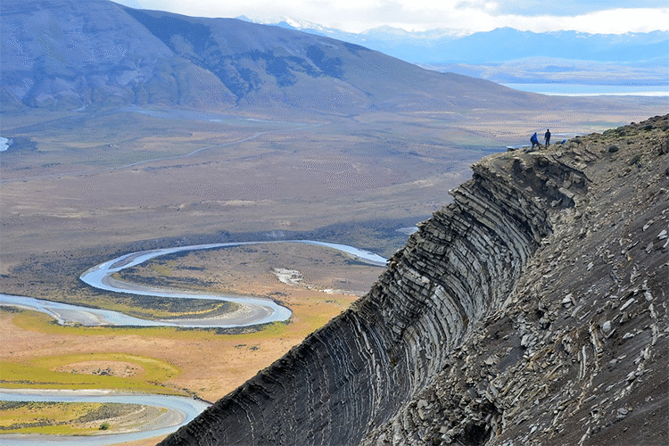
Photograph by Zoltán Sylvester; reproduced with permission.
A sedimentary sequence of mud-rich strata overlain by sand-rich strata is the record of a shift in depositional conditions at a site over time. In the image above, from Chilean Patagonia, the vertical sequence of layers shows that as time went by, there was less and less mud being deposited at this location, and more and more sand. The progressive stack of layers is a record of time, with older, earlier chapters at the bottom, and more recent chapters at the top.
So we’ve made an observation (the shift from muddy to sandy) and that observation begs a question: Why was there less mud and more sand? (In other words, what’s the story?)
Maybe it shows a shift from deeper water to shallower water conditions. Maybe it shows tectonic drift of a landmass into a more energetic, storm-dominated location. Maybe it shows the advance of a submarine fan system spreading onto the abyssal plains of the deep ocean. Maybe it shows the development of a nearby mountain belt, shedding the source sediment. Each of these “maybes” is a hypothesis, a potential explanation for the observation of the sandier layers overlying the muddier layers. The goal of historical geologists is to probe each of these possible explanations and test the ideas against other local details of the geology. Storms rip up mud chips, for instance. Are there mud chips in these sands? Submarine fans often show graded beds. Are there any? Shallower conditions are often marked by a change in the fossil fauna. Tectonic drift can be marked by changes in the paleomagnetic inclination. There are a profusion of additional data we can collect to match up with the different potential interpretations. Generating and considering multiple working hypotheses allows historical geologists a “toolkit of the imagination” when they head into the field.

Photo by Yukio Isozaki; reproduced with permission.
Here is another example, from Inuyama, Japan:
Here, the strata are not in their original horizontal orientation. They have been rotated during tectonic accretion of these deep ocean strata to the Japanese mainland. The layers get younger to the right (rather than “up”). Don’t let that throw you off – You can twist your head to the right if you need to.
The important thing is to note that a distinctive color change occurs across the outcrop: the layers shift from black to red. This is a signature of changes in the amount of oxygen in the deep ocean: there was almost no oxygen (black) and then there was plenty (red). This is interesting because a major mass extinction occurs just before this sequence: the end-Permian mass extinction (also called “The Great Dying”). These strata are 247 to 242 Ma, early middle Triassic, and show the recovery after the mass extinction. Evidence such as this sequence of strata suggest that ocean anoxia (low oxygen levels) were associated with this major die-off in animals, either as a cause or as a consequence. And most everything on the planet died: 95% of species. It was the worst thing that ever happened to life on our planet, and this sequence of jet black layers transitioning to red layers is trying to tell us why it happened. Can we speak Rock well enough to hear the story? Our own species’ future might depend on our ability to translate. This work is important.
Again, no single layer tells the whole story – we must look at the succession of layers over time.
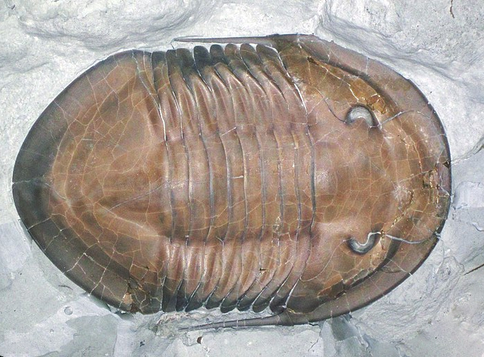
Fossil vocabulary
Within those layers, we find clues of various kinds. One of those varieties of information is fossils. Earth is a planet that has hosted life for most of its 4½ billion years, and especially for the last ½ billion years, there have been plenty of animal skeletons and plant tissues to be included in the strata as clues to when they were deposited. For instance, with the Japanese cherts we just examined; we know how old they are based on the fossil radiolaria that they contain.

Consider an analogy: these piles of old newspapers. Imagine reaching into these stacks and extracting three pages at random. You read them, and find many familiar words and phrases: each is written in English. But also on each of them, you see distinctive words and phrases:
-
- On one: Hepcat. Daddy-O. Supermurgitroid. Peepers. Knuckle sandwich. Made in the shade.
- On another: Moxie. Bee’s knees. Gams. Flapper. Sockdollager. Zozzled.
- On a third: Fain. Forsooth. Betwixt. Thou. Verily. Swain. Hugger-mugger.
These words are all archaic in some sense (i.e., they are no longer in widespread use), but they are also specific to certain periods of time (as well as to English-speaking areas of the world). One set of words derives from the 1950s, another from the roaring 1920s, and the last from Elizabethan England (~1600, as recorded by William Shakespeare). The words alone evoke the time in which the newspaper was written.
Wikimedia Commons
Similarly, in historical geology, fossils are the rich vocabulary that serves to indelibly mark their strata with the time of their formation. Some sediments speak a strain of Rock with a pachycephalosaur patois or a trilobite tone. Others communicate with an ichthyosaur inflection or a brachiopod brogue. As with language, these distinctive fossil “words” are emblematic of a specific time or a specific place, or both.
While sandstones and shales are enduring elements in the language of Rock, fossils are the slang that changes with time and space. Fossils mark the passage of time and tectonics with their unique lexicon.

Photo illustration mashup orchestrated by Callan Bentley.
Like a digital watch on a medieval knight, it would be anachronistic to find an Ordovician fossil in Cretaceous strata. Shakespeare’s characters never said “groovy” or “coronavirus.” And you can’t buy an Anomalocaris at the pet store today. Certain fossils — the ones most useful for constraining the age and place of formation of their host strata — are distinctive enough that we can rely on them as signals of the origins of the sedimentary strata that host them, markers of particular times or places.
Magma, metamorphism, & mountains
Traditionally, Historical Geology has focused its attention on sedimentary rocks, built up in layers and host to distinctive fossils. But this is only one dialect that Earth is capable of speaking. She is equally eloquent when she writes igneous and metamorphic stories, or deforms her earlier works through later episodes of mountain building. In this text“book,” we embrace the full gamut of Earth’s works, giving equal value to the Earth stories we can decode from metamorphic and igneous rocks, and tectonic structures too.
For example, the outcrop below shows a pattern that’s quite striking. Click on it and spin it around to see its distinctive shape.
Igneous is a dialect of Rock with elegant structure and fiery intonation.
3D model by Marissa Dudek & Callan Bentley.
The pattern you observe in the 3D model above is a particularly regular system of fractures that developed in a cooling lava flow. The iron-rich lava erupted 50 million years ago in Northern Ireland, congealed, and cooled down, shrinking as it did so. (Cold rock takes up less space than warm rock.) The contraction induced tensional stresses across the surface of the lava flow. These stresses were greater than the strength of the freshly-solidified rock, and it cracked. The fractures met each other in a “honeycomb” like pattern on the surface of the flow, and then propagated down into the flow’s interior, dividing the warm young rock into a series of cold polygonal pillars.
The locals were so impressed with the precise regularity of this pattern, they were convinced it must have been constructed by a conscious mind. They spun a legend to explain it – a tempestuous giant named Finn MacCool (Fionn mac Cumhaill), trying to pick a fight with a Scottish giant named Benandonner. Benandonner had been so bold as to claim Ireland as his own, and Finn wouldn’t stand for it! Finn started pitching rocks toward his rival and realized he could build out a causeway to connect the two landmasses. He journeyed to Scotland (specifically, to the island of Staffa) to confront the usurper, but got scared by Benandonner’s size, and rushed back across the causeway to Ireland. The Scot pursued but was tricked into a hasty retreat thanks to some clever subterfuge by Finn’s wife Sadhbh (pronounced “Siive”). She dressed Finn as an infant, and told Benandonner that he was in fact merely Finn’s baby, and that big daddy Finn would be home soon! Benandonner beat his own hasty retreat, knocking the causeway to pieces as he fled. The site is therefore known as the Giant’s Causeway.
Geologists have a different way of explaining the Giant’s Causeway, of course. Because they speak Rock rather than Giant, they note that on a landscape scale, this lava flow is one of many that erupted in a vast region between 60 and 50 million years ago, smothering the local landscape as they flowed and pooled. The volcanic activity was not limited to Ireland and Scotland. It also produced basalt in the Faroe Islands, Norway, and Greenland. Collectively, all of these sites are the North Atlantic Igneous Province (NAIP). The Paleogene-aged lava flows link them all to be in the same spot around 60 million years ago, marking them all with a common stamp prior to the various landmasses separating from each other, with the Atlantic Ocean opening up in between.
The cause of this eruption may have been the Icelandic hotspot, which continues erupting similar lava today at the Mid-Atlantic Ridge. The now-widely-dispersed basalts of the NAIP help link together landmasses that experienced divergent tectonics during the Paleogene, and have been moving apart ever since.
Furthermore, the timing of the NAIP’s eruption overlaps with a time of extreme global warming, the Paleocene-Eocene Thermal Maximum (PETM), and some scientists have suggested that CO2 emissions from the lava may have been the cause of this superlative episode of global warming. As with the end-Permian extinction, that is potentially really important: a matter of some urgency to Rock-fluent humans who are living in their own time of global warming.
Bottom line: Igneous rocks are just as vital as sedimentary rocks in interpreting Earth history.
On the metamorphic front, consider this blueschist:
Callan Bentley GIGAmacro
Blueschist is a metamorphic rock which is blue and flaky. But like all metamorphic rocks, it didn’t start off that way. This blueschist started as basalt – the same sort of mafic volcanic rock we just saw at the Giant’s Causeway! The fact that it doesn’t look like that any more is evidence of a profound journey it took – from Earth’s surface down deep into its interior, down 40 or maybe 50 kilometers into the mantle. Down there, temperatures were hotter, but more importantly, the pressure was insanely high. The minerals making up the basalt couldn’t take it: they reacted and fell apart and their atoms recombined to make new minerals. The new minerals were chemically stable under the crushing pressure.
This distinctive blend of minerals is therefore evidence of a journey. Like an astronaut coming back from the Moon, the blueschist has come back from a place none of us will ever get to go. Its minerals tell a story, like stamps in a passport. The best travel stories are written in Metamorphic.
Scars tells stories too, and Earth has picked up her share of scars through the years. For the most part, these “scars” are tectonic structures like folds, faults, and shear zones. Consider this photograph of the Andes Mountains in southern Argentina:

Photograph by Zoltán Sylvester; reproduced with permission.
Rock layers are laid down in layers that are pretty close to horizontal, perhaps as steep as 30° (the angle of repose). But when you see them as in this Patagonian mountainside, with some of the layers upside-down, you know that they must have been seriously contorted sometime after their original deposition. After all, you cannot deform a rock layer without first having formed it.
Stories can be extracted not only from the sequence of sedimentary layers in this case, but also from their contortion, their orientation, their elevation, and their shape. Structure is the most passionate strain of Rock vernacular. If we ignore the structure of the mountainside, we potentially miss out on the most dramatic stories these rock layers have to tell.
Earth’s story is your story
Why should you care about any of this?
You are an Earthling. You are were born on this planet, and you will live out your entire life on its surface. The atoms from which your body is constructed are atoms that have been on this planet for more than four billion years, repurposed endlessly before becoming part of you, and destined for continued eternal recycling after you die. The carbon that makes up your eyeballs, your neurons, and your fingertips was derived from food you ate, and the plants who captured that carbon pulled it from the atmosphere, and it got there perhaps from volcanic emissions, or exsolution from the ocean, the rotting of a dinosaur, or the combustion of ancient coal. You are literally made of Earth bits. When you eat or breathe or pee, you are connecting with the Earth, as surely as a child poking around in the soil.
Callan Bentley photo.
You and I are fortunate to live on a very interesting planet. Earth is big enough to have differentiated. This allowed the development of a metallic core, whose circulation powers a magnetic field that protects our atmosphere from erosion by the solar wind. Differentiation also provides for mantle convection, the power source driving plate tectonics. The eruption of volcanoes and gravitational acquisition of comets both yield water, and this water is critical for life. Every critter and microbe needs liquid water, and for 4.5 billion years, our planet’s surface has had the right blend of solar heating and greenhouse gas insulation to keep the water flowing. What fortune! Every move we make, every breath we take, we rely on geology.
How has this charmed situation come to pass? If you speak Rock, you can learn some of the backstory. If you speak Rock, a drive through the mountains or the patterns in a fancy countertop become interesting tales, potentially shocking revelations. If you speak Rock, you can answer questions about the circumstances that led to your very existence.
Understanding Historical Geology is essential work for the sake of our species’ future, and —more personally — for the sake of feeling at home here on the most fascinating planet in the neighborhood.
________________