Plate tectonics: what governs Earth’s surface dynamics today
As we have covered elsewhere, the way the world works today is largely governed by plate tectonics: the differential movement of large plate-like slabs of the planet’s lithosphere, mainly horizontally, but with significant vertical motion too at sites of subduction and continental collision. The fathomless deep sea trench or a towering Himalayan-style mountain range are ephemeral topographic features, however. While they allow us to spot plate boundaries at a glance today, they don’t last over geologic time: the trench gets filled in with sediment; the mountains are eroded to their roots.
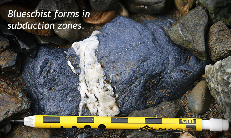
Callan Bentley photo
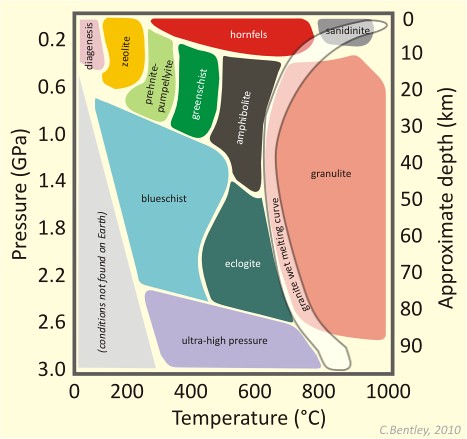
So how can we figure out when plate tectonics began on this planet? We must look to other aspects of the geologic record. This is a vibrant area of research in geology now, and there is genuine scientific controversy about how best to interpret a patchy record. This much is agreed upon, however: Plate tectonics results in several features that are decisive “signatures” of its operation, and are potentially “durable” enough to persist in the geologic record through time. First is the production of blueschist as an example of a high-pressure but low-temperature metamorphic rock, only results when you have the subduction of old, cold, dense, oceanic crust. The oldest known blueschist on Earth is merely Neoproterozoic in age (Condie and Kröner, 2008, and references therein).
Second, blueschist is usually associated with other subduction metamorphic rocks, such as eclogite. Distinctive minerals, including glaucophane (a blue amphibole mineral that makes blueschist blue) and lawsonite mark these rocks. But the belt of “subduction metamorphic rocks” is paralleled by a second belt of metamorphic rocks, with a higher temperature signature, the rocks forming in association with the accompanying volcanic arc. These include classic Barrovian metamorphic minerals (sillimanite, staurolite, garnet, etc.) in rocks such as phyllite, schist, and gneiss.
The set of two parallel belts with different temperature/pressure regimes is the key observation: that’s how it works today, with plate tectonics. And unlike the deep trench or the towering volcanic arc, the paired belts of rock with distinct metamorphic signatures stand a good chance of being preserved in the geologic record.
But as we go further and further back in the geologic record, we see fewer and fewer blueschists, and fewer and fewer paired metamorphic belts, forcing us to conclude that plate tectonics was not always the way the Earth’s outer rocky layer behaved.
Did I get it?
It was different in the Archean
We don’t find blueschist in Archean rocks. We don’t find paired metamorphic belts in Archean rocks. It appears, therefore, that plate tectonics was not operating on Earth in that early time. Instead, our oldest rocks appear distinctively different, in both rock type and structure, and they therefore imply a different tectonic regime for Archean Earth.
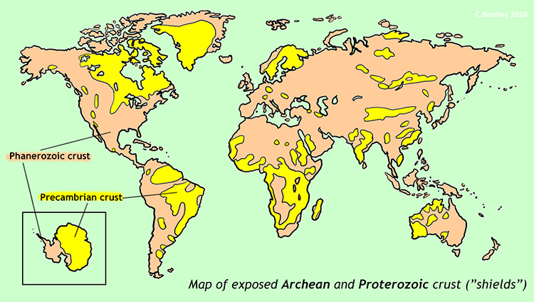
So what was that “style” of tectonics, and what is the evidence for it? The oldest coherent features we see that can answer this question are called greenstone belts. These are linear or branching zones of distinctive low-grade metasedimentary and metavolcanic rocks. Notable greenstone belts on Earth include examples from the oldest parts of the cratons of Australia, South Africa, Europe, Siberia, Brazil, Antarctica, India, Greenland, China, and northcentral North America. All are included in otherwise fairly homogenous felsic crust of similarly ancient age. We call each of these “continental nuclei” by the term craton. Where the craton’s rock is exposed at Earth’s surface, we call it a “shield.” Areas where the craton is present, but buried beneath a sedimentary blanket, are called “platforms.”
Callan Bentley graphic
Examples of cratons include the Pilbara Craton of Western Australia, the Kaapvaal Craton of South Africa, and the Superior Craton of the U.S. and Canada. The greenstone belts are typically sandwiched between large bodies of crustal rocks such as granite and gneiss. Not all greenstone belts are Archean; some are also known from the Proterozoic. But the Proterozoic’s tectonic record is more diverse, so for the sake of this case study, we will focus on the Archean.
The greenstone belts are interpreted as the remains of ancient ocean basins, which were squished between ancient proto-continental terranes, in the same sense as how in modern plate tectonics, ophiolites mark the position of former ocean basins. The process of partial melting had repeatedly “distilled” the silicate crust of the planet into small mobile blobs, roughly the size of modern U.S. counties or states, and once solidified, these resisted subduction due to their low density. They drifted about, approaching other similar granitic terranes, with the intervening ocean basin sagging out of the way, straight down below. The more sagging occurred, the more room there was for sediments to accumulate atop the subsiding region, until the neighboring granitic blobs got close enough to compress the rocks between them. Once they collided, they often stayed stuck together, resulting in a granite/greenstone belt/granite horizontal sequence.
Let’s now examine them in more detail, starting with the roster of rocks we find in greenstone belts, and progressing to an overview of their large-scale structure.
Did I get it?
Rocks found in greenstone belts
Rock types in greenstone belts are of both igneous and sedimentary varieties. In general, both tend to be lightly metamorphosed (greenschist facies). Here we will examine the igneous ones first, both volcanic and plutonic, and then move on to the sedimentary ones.
Igneous
Basalt and komatiite
Callan Bentley photo
Volcanism and plutonism have been themes in Earth history from very early times. In the fact that they show evidence of the production of magma and lava, Archean greenstone belts are not that different from modern oceanic ridge systems.
Basalt was a common rock then as it is today. Greenstone belts get their very name from this prominent rock, which served as protolith for the low-grade metamorphic rock called greenstone. Then, as now, basalt erupted as mafic lava onto or near Earth’s surface, cooling rapidly to make a fine-grained igneous rock. We know there must have been at least some water present, because greenstone belt basalts include pillow structures, features that form when basaltic lava erupts underwater. Other primary volcanic structures include vesicles, the “fossil gas bubbles” that formed as exsolved gases were trapped in solidifying lava.
Callan Bentley photo
While basalts in greenstone belts looks more or less like basalts forming today, that’s not true for komatiite, an ultramafic volcanic rock. It is named for the Komati Valley of South Africa, a river valley in the area of the Barberton Greenstone Belt. Komatiite is often cited as an example of an “extinct rock,” since it hardly ever forms on Earth any more. The reason for its formation in the Archean but not today is temperature. Komatiite is dominated by the mineral olivine, and olivine has a very high crystallization temperature, around 1500°C. Lavas that hot don’t erupt on our planet today; a more typical temperature for a modern mafic lava (like the Kilauea volcano in Hawaii) would be around 1100-1200°C.
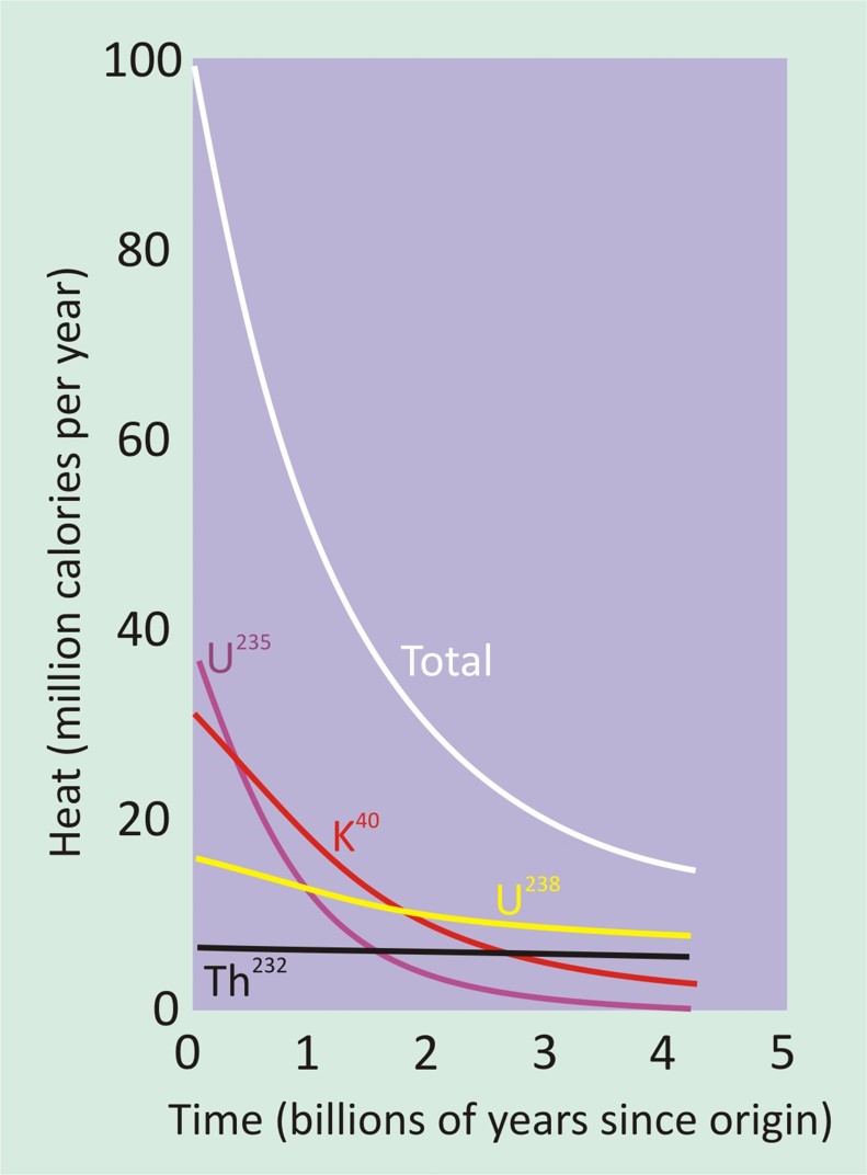
Callan Bentley graphic
The fact that we see komatiites in Archean-aged deposits is strong evidence that the early Earth was hot. At least internally, it was hotter than today. Why was this? A few reasons: (1) First, less time had passed since the planet was assembled from an unthinkable number of meteorite impacts, events that instantaneously transformed a very high kinetic energy into heat energy. So it was “still hot,” like a pie recently removed from the oven. It may be cool on the outside, but you’ll burn your mouth if you take a bite! (2) Second, the rate of new heat production was much higher in early Earth history. Less than a billion years after the nebula-forming supernova of Earth’s predecessor star, there were a lot more unstable (radioactive) isotopes around. Remember that [link to numerical dating discussion here] half of a population of radioactive atoms fall apart in the first half-life, followed by a quarter of them in the second half-life, followed by an eighth in the half-life after that, and so on. Totaling all known radioactive isotope sources suggests something like five times as many radioactive decay events in the Archean as today. So there was a much higher level of heat production in the first eons of Earth history than there was in subsequent eons.
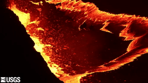
From a video by the USGS.
In summary, not only was the planet hot from its initial smash-up mode of formation, but radiation also kept it “on a hotplate” for its initial stages. Only gradually did that heat naturally get “turned down” over time, as there were fewer and fewer unstable isotopes left to decay and make new heat. The result was that the mantle, and the crust it produced, were both much hotter than they are today. Things were hot enough that ultramafic magma stayed molten all the way to Earth’s surface, and was erupted hot to flow as lava.
Examine this pair of komatiite samples and note two features: (1) the prominent brownish-orange weathering rind, indicating the high iron content of the rock, and (2) the long needle like crystals of olivine, a feature called “spinifex texture.”
Callan Bentley GigaPan
Though komatiite is a volcanic rock (and thus we would expect a mostly fine-grained aphanitic texture), these large crystals of spinifex olivine are a common sight in komatiite outcrops, particularly near the top of the lava flows. Apparently, as the ultramafic lava lost heat, it began to crystallize most rapidly from the top down. Crystals of olivine nucleated on the chilly upper surface of the flow and then grew downward into its molten interior, hanging into the molten rock like chandeliers on the ceiling. Meanwhile, chunkier olivine crystals nucleated within the flow, free floating and untethered. These settled to the floor of the komatiite flow, building up a cumulate layer there.
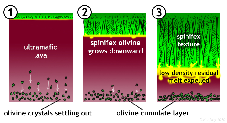
Callan Bentley cartoon
Did I get it?
Tonalite, trondjhemite, granodiorite suites
Granite is a coarse-grained, felsic igneous rock. Its coarse grained (phaneritic) texture indicates it cooled slowly, which implies it cooled underground – that is to say, it is intrusive. Granite is a common rock of the modern continental crust. There are granite-like rocks in Archean cratons, too. Technically, these are not precisely granite, but instead a suite of three similar plutonic rocks: tonalite, trondjhemite, and granodiorite. Collectively, this trio of rocks are often called the “TTG” suite. The distinction between TTGs and a true granite is the absence of the mineral potassium feldspar in the TTGs.
Here is an example of one such unit: an outcrop of the Kaap Valley Tonalite, a 3.2 Ga pluton from South Africa’s Kaapvaal Craton. Explore it and and count how many different textural or compositional aspects to the pluton you can find:
Callan Bentley GigaPan
Overall, we think that the TTG plutons originated the way modern granitic plutons originate: through the partial melting of other rocks, “sweating out” a magma of the easiest-to-melt minerals (those at the bottom of Bowen’s reaction series). Those minerals are nonferromagnesian and silica-rich, and the result is a felsic magma. Then as now, those magmas cooled slowly underground, developing a coarse-grained texture.
Did I get it?
Sedimentary
Chert
Interestingly, the oldest Archean sedimentary rocks are not silicliclastic. There are no sandstones. There are no conglomerates. There are no shales. This implies, quite strongly, that there was no land exposed above sea level – no rock exposures available for weathering and erosion. But underwater, there were still chemical sedimentary rocks forming due to mineral precipitation from the ocean. Among the oldest Archean sedimentary rocks is chert.
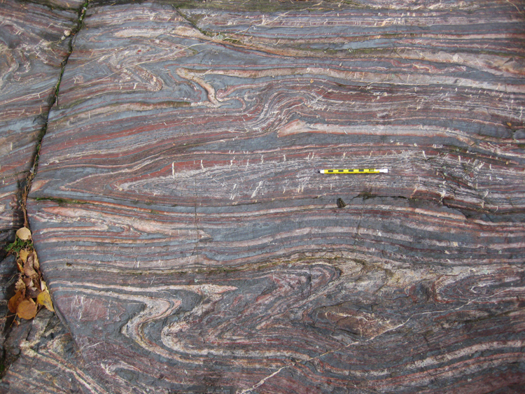
The Barberton Greenstone Belt’s Buck Reef Chert is one of the most extensive chert deposits in the Archean geologic record. It is thick and covers a wide area, and records an extended period of chemical precipitation of silica from seawater, sometime around 3.4 billion years ago. Examine this boulder of the Buck Reef Chert, and consider its alternating black and white layers, subsequent faulting, veining, and pressure solution, and a modern surface veneer of lichens.
Callan Bentley GigaPan
Did I get it?
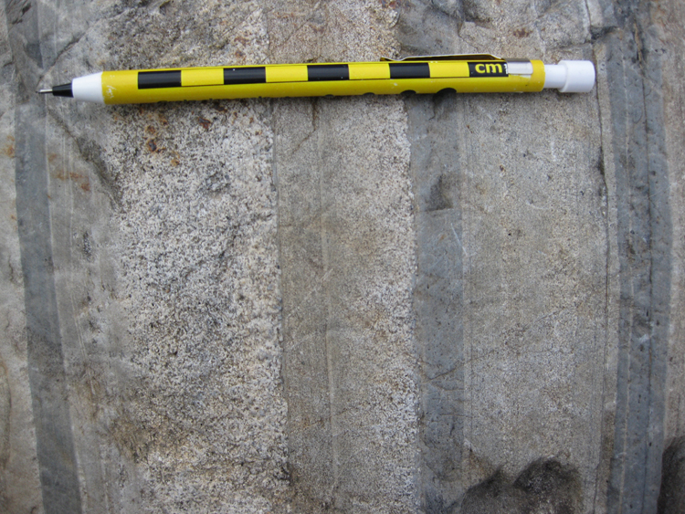
Banded iron formation
Callan Bentley photo
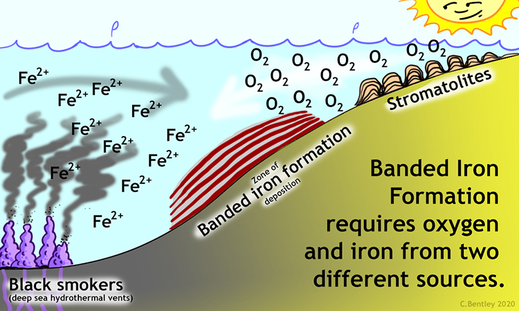
Banded iron formations (‘BIF’s) are another distinctive kind of chemical sedimentary rocks, known only* from the Archean Eon and subsequent Paleoproterozoic Era. They are chemical sedimentary rocks composed of alternating layers of iron-rich oxides (usually hematite or magnetite) and silica precipitates (chert or jasper). Banded iron formations are the main ore of metallic iron for human use, but in the context of Historical Geology, the thing that’s really interesting about BIFs is that they are a signature of radically different ocean chemistry, and therefore also imply a radically different atmospheric chemistry.
Specifically, BIFs imply a world without widespread free oxygen. This is hard for us to imagine, considering that oxygen makes up around 21% of Earth’s modern atmosphere. But oxygen is a highly reactive element, and it likes to form bonds with other atoms. After all, about half of Earth’s crust is oxygen, it’s just bonded to silicon and other elements to make up minerals.
Callan Bentley GigaPan
As to the rhythmic nature of the alteration in BIF’s internal composition, several hypotheses have been proposed. One possibility, the straightforward one, is that these are primary sedimentary layers: bedding, in other words. In that case, a rhythmic alteration in sediment source is required. This sedimentary “rhythm” is potentially tidal, seasonal, or represents fluctuations in the position of the chemocline (a boundary within the water column separating anoxic, iron-rich water below from oxygenated, iron-free water above). However, another possibility is that the original sedimentation was more or less homogeneous, and only later during diagenesis did the silica-rich and iron-rich components separate out from each other into layers.
Regardless of the details, BIF’s mode of formation must have been a chemical compromise between the upwelling waters loaded with dissolved iron and shallow surface waters, pumped full of oxygen by the photosynthetic action of microbes, including those microbial mats we today call stromatolites.
Callan Bentley cartoon
Did I get it?
Turbidites of graywacke and shale
Callan Bentley photo
Later in the Archean, enough land had risen above sea level that significant quantities of siliciclastic sediments were produced: mud, sand, and pebbles. Turbidity currents flowed into deep-water marine basins of the Archean, adjacent to significant sources of clastic sediment such as proto-continental terranes. Then, as now, these turbidity currents transported a slurry of sediments of different sizes. As the current slowed, its capacity dropped, and sedimentary grains settled out, in order of their weight. The biggest ones tended to be the heaviest ones, and settled out first, followed by progressively more and more lightweight grains (which tended to be smaller). The result was a graded bed: coarse at the bottom, fine at the top. Using this pattern, can you tell which way is stratigraphic “up” in the graded bedding photo here?
Shallow-water sandstone with microbially-induced sedimentary structures
In shallower water, in river deltas and nearshore settings, there were better-sorted, more mature sand deposits, dominated by quartz sand. These sand deposits record evidence of widespread microbial mats, preserved as thin, sediment-binding dark layers called “microbially-induced sedimentary structures” (MISS). These are essentially the siliciclastic version of stromatolites. Here’s an example from Barberton, seen in cross-section:
Callan Bentley GigaPan
Photographs by Nora Noffke; reproduced with permission.
Next, consider an example from the Pongola Supergroup in Africa, as viewed on the bedding plane, and compared with a modern analogue. Many MISS show soft-sediment (and soft-mat!) deformational features such as rips and tears, wrinkles, and “elephant skin texture.” Sometimes they are rolled up, or folded back on themselves.
MISS show us that microbial mats were a key feature in Archean sedimentary systems, helping to bind sediment in place. They also show us that at least one aspect of the biology on Earth has been consistent for billions of years.
Did I get it?
Conglomerates
Callan Bentley photo
Some Archean sediments are very similar to modern day conglomerates – full of cobbles and pebbles and sand, that were deposited by fast-moving river currents. Based on their size, sorting, and the rounding of the cobbles in them, we think they accumulated in modestly-sized wrench basins formed in releasing bends along the edges of transpressional embryonic orogens. The clasts that make up these conglomerates tend to be volcanic in origin, as one might expect for a hot, young, immature planet. As small proto-continental masses were colliding with one another along what we today call greenstone belts, dilational wrench basins opened up, ready to receive the sloughed-off clastic detritus of the primordial mountains.
Some Archean conglomerates contain sand grains and pebbles of pyrite. These detrital pyrites are primary sedimentary grains, not some later manifestation of metamorphism. While pyrite exists as a mineral in the modern world, we never see it as a major constituent of sediment, because it rapidly rusts (oxidizes) in the planet’s current oxygen-rich atmosphere. The fact that pyrite grains could tumble along, getting physically rounded but not chemically weathered is a surefire signal that the atmosphere of the Archean Earth was decidedly oxygen-poor. In this way, the “testimony” of the detrital pyrites corroborates the testimony of the banded iron formations we discussed earlier.
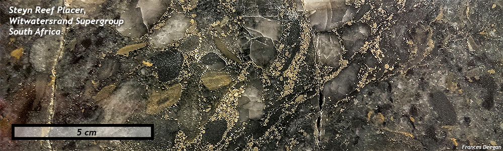
Photo by Frances Deegan; reproduced with permission.
Meteorite impact strata
Callan Bentley photo
Another unusual aspect of really old sedimentary rocks is that they record a fair number of violent meteorite impact related rocks. Theoretically, we would expect more meteorite impacts in early Earth history than today, since then the Archean was much closer in time to the planet’s accretionary formation. Since then, we’ve had more than three billion additional years of the planets’ gravity cleaning stray chunks of space rock out of our solar system. in other words, we expect the number of meteorite impacts to decrease through time.
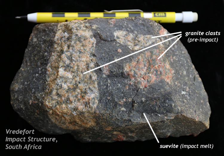
But during the early Archean, even though the Late Heavy Bombardment had concluded, impacts were still fairly frequent events. Fortunately, we can now begin to read the story of their impact because unlike the Hadean, a rock record still persists from the Archean. The record of impacts is recorded in rocks that come in several varieties: ejecta and fallout as well as jumbled and disturbed sedimentary layers deposited by tsunamis, rocks that record perturbations in ocean chemistry due to the impact, and also rock melted directly by the collision, called suevite.
A famous example of suevite can be found in the Vredefort Impact Structure in South Africa, and and even older example occurs in the Sudbury Impact Structure of southern Ontario in Canada. In both cases, clasts of pre-impact basement rocks (granites, mostly) are found ripped up and “floating” in the glassy suevite.
Events energetic enough to melt rock also blasted rock high into the sky, generating energetic clouds of suspended ash and water vapor, violently twirling around (generating static electricity). Clumps of ashy particles formed, and grew layer upon layer in the manner that hailstones do. We call these odd little sphere-shaped structures “spherules” and they are present in sedimentary layers of the time. Violent volcanic eruptions (of ultramafic komatiitic composition) also produces little “volcanic hailstones” in the same fashion, though it didn’t take a meteorite impact to make them happen. Their similar-shaped (and sized) structures are called “accretionary lapilli” rather than spherules, but they are essentially the same thing. Compare the two (both Archean, from the Barberton Greenstone Belt) below:
Callan Bentley GigaPans
Meteorite impacts, being violent events on an Archean planet without true continents, were very likely to happen in the oceans, which generated tsunamis. These high-energy events ripped up pre-existing strata and mixed them with spherules, redepositing the mix as energy conditions abated and the waters calmed, as seen in the virtual sample below. See if you can find a foliated chunk of basement rock, an angular chunk of chert, and a spherule…
Callan Bentley GigaPan
Another consequence of crust-piercing, ocean-churning impacts was to alter the chemistry of the oceans radically. One interesting feature associated with impact-origin strata are odd chemical sedimentary deposits of barite, a mineral rich in the element barium. Note that these strata show bedding-perpendicular oriented crystal forms that are interpreted as nucleating on the ocean floor and growing ~vertically upward into the water column. Ocean chemistry must have been seriously weird to permit such odd layers:
Callan Bentley GigaPan
Did I get it?
Metamorphic
Greenstone
Callan Bentley graphic
As their name implies, greenstone belts have seen relatively light levels of metamorphism: merely “greenschist facies,” which is sufficiently hot and high-pressure to transform basalt to greenstone (or its foliated equivalent, greenschist) but this allows certain primary features such as vesicles, pillows, and cooling columns to persist. There are no high temperature+pressure metamorphic rocks (e.g., amphibolite, granulite), nor subduction related blueschists (high pressure and relatively low temperature).
Because the volcanic and sedimentary packages of greenstone belts were protected by the surrounding buffers of “granitic” material (see next section), they were never subjected to proper modern-style mountain-building or subduction, and this is a good thing from the perspective of the historical geologist, as it has allowed subtle, delicate primary features to survive, relatively undisturbed, for billions of years! If this hadn’t been the case, we would today find completely recrystallized metamorphic rocks, and instead we can see primary features such as these pillow basalts in Michigan:
Ron Schott GigaPan
Did I get it?
Structure of greenstone belts
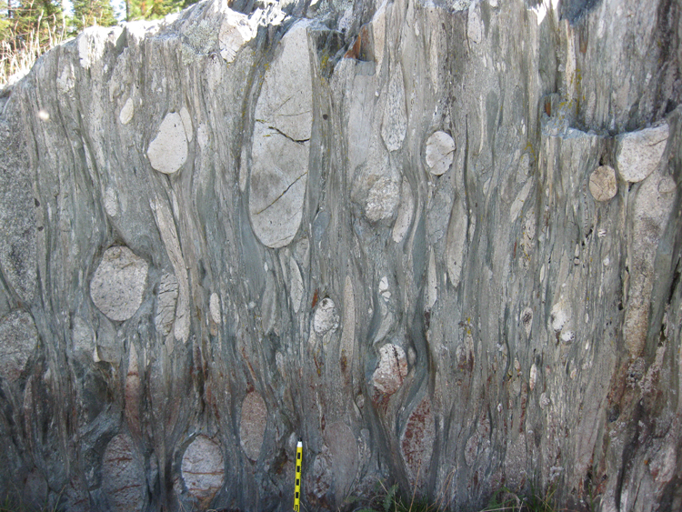
If you examine a map view of the Pilbara Craton in Western Australia, you’ll see a distinctive pattern of shapes… Ignore the roads and towns, and focus on the colors and shapes in the unvegetated landscape instead:
Notice there how there are broad oval shaped light colored features, separated by more linear dark colored rocks? This is a fairly typical arrangement of rocks in Archean crust. The big light colored features are ‘granite’ (really: tonalite, trondjehmite, and granodiorite) and the dark colored lines separating them are steeply dipping layers of lightly metamorphosed volcanic and sedimentary rock. In the third dimension (depth), we think the metavolcanic and metasedimentary cover sequence pinches out, making a thin septum between blob-like granite domes. We call this geometry “dome and keel,” and it’s thought to represent a kind of vertical tectonics that dominated during the Archean. Here’s a diagram showing the relative motion of the plutonic domes and the surface strata folded into the thin keels:
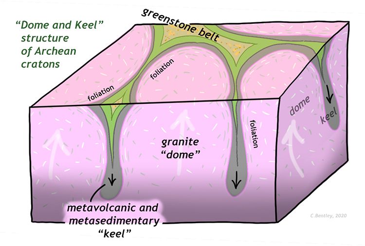
Callan Bentley cartoon
The idea here is that the crust hadn’t yet organized itself into thick, laterally-continuous slabs like plates. Instead, on a much smaller scale, the primordial crust was forming through both plutonic processes (pushing up from below) and surface processes (eruption of lava and production and deposition of sediment). The rising domes of granite moved vertically, and to accommodate this relative motion, the surface rocks sagged downward, perhaps even foundering (akin to a sinking ship) and “dripping” into the dynamic mantle.

Geological Survey of Canada map
Though Archean cratons and greenstone belts tend to be in relatively placid corners of the modern Earth, where we can’t get a significant view into their three-dimensional structure, airborne magnetometry and gravitotometry can produce some insights into their structure, as this magnetic map of a greenstone belt in Manitoba, Canada, shows.
Overall, the dome-and-keel structure suggests that during the Archean, vertically-oriented, small-scale tectonics dominated, forming stable cratons of continental crust that have fortunately persisted until the present day, where they form the nuclei of most continents.
Did I get it?
Further reading
Condie, K. C., & Kröner, A. (2008). When did plate tectonics begin? Evidence from the geologic record. In When did plate tectonics begin on planet Earth (Vol. 440, pp. 281-294). Geological Society of America Special Papers.
Klemetti, Erik. “The Lava That Doesn’t Erupt Anymore,” WIRED, October 2016.