Geologic virtual field experience to Glacier National Park, Montana:
-
- Overview
- Stratigraphy
- Structural geology
- Glacial geomorphology (this page)
During the Pleistocene epoch, Earth experienced an overall cooler than average climate, which alternated between glacial and interglacial conditions several dozen times. Repeated oscillations between ice-building and ice-melting conditions correlate with variations in Earth’s orbit around the Sun. In the northern hemisphere, both mountain glaciers and ice sheets have waxed and waned in response. In some places, the flow of these glaciers has sculpted the landscape through erosion, and modified it elsewhere through the addition of glacially-transported sediment.
Examine this physiographic map of the region to see the distinctive topography that results from the action of these moving “rivers of ice” on a mountain landscape:
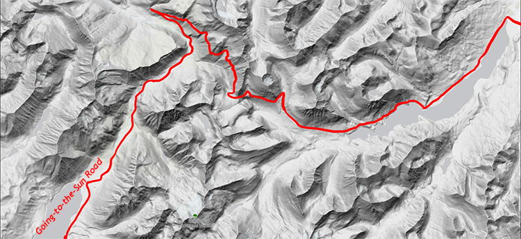
If you click on that map, it will take you to a dynamic map where you can zoom in and out and explore the topography in more detail.
Pleistocene glaciation
The last 2.1 million years of geologic time have been cold relative to the bulk of global climate history. Starting shortly after the Isthmus of Panama formed, diverting the Gulf Stream northward in the Atlantic, and oscillating in rhythm with slight variations in Earth’s orbit around the Sun, the Pleistocene epoch is characterized by repeated advances and retreats of glacial ice, particularly pronounced in the northern hemisphere. Nominally, the Pleistocene ended 10,000 years ago with the start of the Holocene, but from a zoomed-out perspective the Holocene looks an awful lot like the 30 or so interglacial periods that preceded it, every 100,000 years or so, throughout the Pleistocene.

Callan Bentley graphic
The glaciers of the Pleistocene were important agents of change for the landscape. They reshaped it in two major ways: (1) by removing rock from some areas (this scraping generated particles we call sediment) and (2) by depositing that sediment somewhere else. There are glacial landforms that result from the removal of rock and other glacial landforms that result from the deposition of sediment in another location.
Erosional landforms of alpine glaciation
Processes of glacial erosion
Above the high elevations of the mountains, air masses are forced upward, which cools them and triggers condensation and deposition (the processes by which water vapor turns to liquid water or ice). All else being equal, precipitation falls in greater amounts over mountains than surrounding lowlands. High elevation land is also cooler than low elevation land, and any snow that falls there is more likely to persist. As a result, snow tends to accumulate in temperate mountain regions. During an ice age, the amount of snow that builds up is greater than the amount of snow that melts away. This is the precursor to glacial ice.
When the snow gets to be about 50 m (150 feet) thick, the pressure of the overlying snow compacts the snow below into ice, and this ice begins to flow. The flow is a solid-state flow, akin to putty or warm wax. Gravity pulls the ice mass downward, and so the glacier begins to flow downhill. It will utilize pre-existing drainages (valleys) on its path downhill. Moving downhill into open air is easier than moving downhill into solid rock, so the pre-glacial valleys end up being retained as pathways even after they are filled with ice. This BBC video shows the process very well.
Glaciers erode the bedrock in two major ways: (1) abrasion and (2) plucking. Abrasion is a grinding, sandpaper-like process, where rock particles of many sizes are entrained in the glacial ice and scraped against the bedrock as the ice flows over it, gouging the solid rock on many scales. This gouging results in the liberation of new particles, which then also become agents of abrasion.

Animation from Landsat photography by F. Paul, USGS
Plucking is a bit more complicated. Ice is a mineral, and when it is subjected to higher pressures, it dissolves (liquid water takes up less volume than ice does). When it encounters lower pressures, it refreezes. When glacial ice flows against some obstacle of bedrock, it dissolves on the upstream (uphill) side, flowing through cracks in the rock, and refreezes on the downstream (downhill) side. As it refreezes, it rejoins the glacial ice mass and potentially surrounds blocks of bedrock. In Belt strata, these blocks of bedrock are defined by the bedding plane and joints that are perpendicular to bedding. The ice-turned-high-pressure-water infiltrates these planes of weakness and, once refrozen, liberate the blocks from their original place.
Did I get it?
The shape of the landscape
Abrasion and plucking change the shape of the mountain landscape they flow over. The glaciers gouge downward and outward, resulting in scoop-shaped valleys that show a U-shape in profile. This is in sharp contrast with the V-shaped valleys that rivers carve. When these valleys intersect in various ways, they generate a variety of distinctive landforms. When the glaciers melt away, the landforms are left as testimony to their former occupancy of the land.
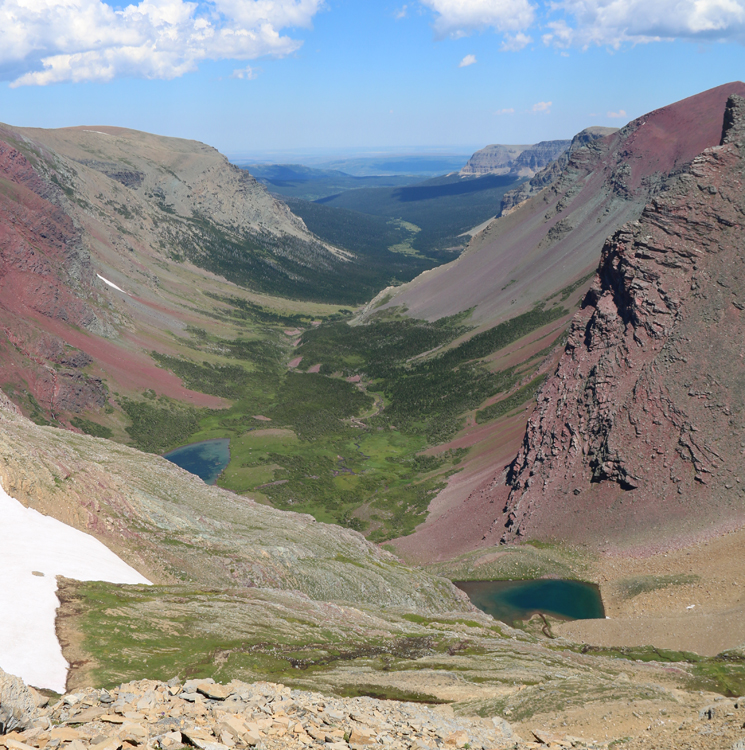
U-shaped valleys
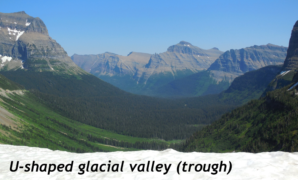
Much of the grandeur in Glacier National Park comes from its extraordinary valleys, which are wide and then curve gently into near-vertical cliffs on either side. Unlike rivers, which focus their erosion downward in a relatively focused zone, and may be surrounded by broader floodplains, glaciers can erode on their bottoms simultaneously with erosion on their edges. While rivers cut V-shaped valleys, alpine (mountain) glaciers cut U-shaped valleys, and even after the glaciers are gone, the mountains retain this distinctive signature of their former presence.
Callan Bentley photo
Cirques
Each U-shaped valley has a scoop-shaped head, as if an ice-cream scoop was plunged downward and outward from the upstream end of the glacier.
Arêtes
When two U-shaped valleys run parallel to one another, and gradually eat away at the bedrock ridge between them, a thin fin of rock is etched out. Glacier has many examples of arêtes, including the Garden Wall. Fusillade Mountain lurks prominently in the background of the most photographed scene in the park, Wild Goose Island. Viewed end-on, it might look at first like a horn, but it’s really an arête, as a side-view shows!
Horns

Callan Bentley photo
When several concave-out cirques point away from a central, isolated peak, it gives the peak a shape like a pyramid. There are dozens of examples of horns in Glacier National Park.
An excellent example is Flinsch Peak:
Hanging Valleys
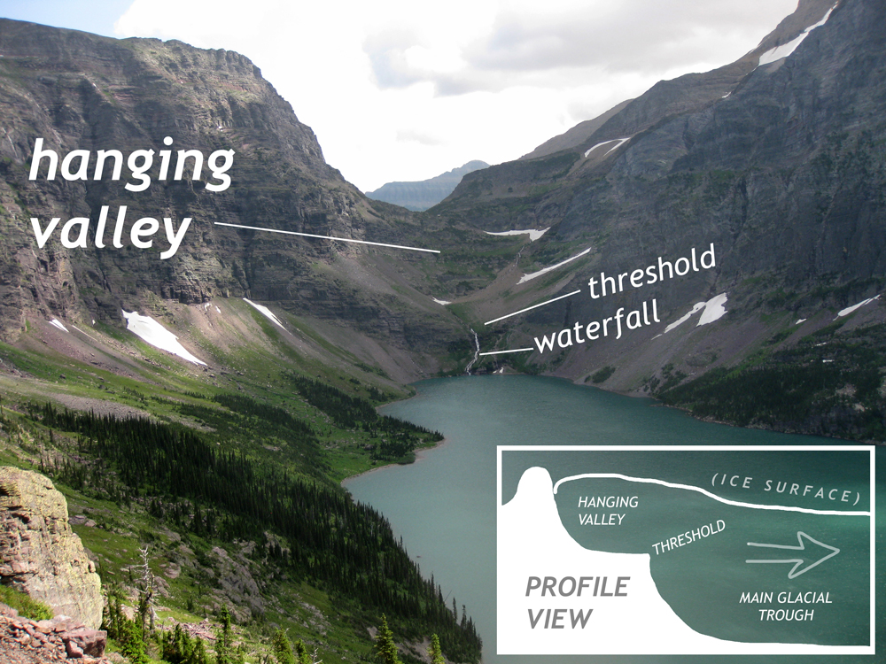
Like rivers of flowing water, glaciers have tributaries and main “trunk” ice streams. Unlike rivers, however, these tributary glaciers flow into the main glacier in a way that merges the two ice streams at the top rather than at the lowest point. This means that when the ice has all melted away, what’s left is a tributary valley “hanging” above the main valley, where the valley floor of the tributary glacier is far higher in elevation compared to the main glacial trough. Any rain or meltwater collected by the hanging valley coalesces into a stream, which then flows downhill and over the “threshold” of the hanging valley, creating a waterfall. Bridalveil Falls in Yosemite National Park is a classic example of this phenomenon, but there are literally dozens of examples in Glacier National Park, too.
Roche Moutonnée

Roche moutonnée are knobs of bedrock that have had a glacier slide over top of them. On the up-current side of the knob, the ice scours a gently-inclined ramp-like surface into the rock. On the down-current side of the knob, the glacial ice plucks large boulders from a steep downhill-facing cliff. The result is an asymmetric hill of solid rock, shaped something like a grazing sheep, with its head down in the grass and its rump poking up in the air. The name “roche moutonnée” translates from the French as something like “rock sheep” (or “rock mutton“). With this mammal mnemonic in mind, remember that grazing sheep faces up the glacial valley, in the direction from which the ice originated.
Striations

Callan Bentley photo
Because the ice is constantly grinding directly against it, the upstream end of a roche moutonnée is likely to be covered in striations (sometimes called “striae”). These are nothing more than scratches, as cobbles and boulders entrained in the glacial ice are dragged slowly but firmly over the bedrock surface. These striations are therefore a record of glacial flow direction, and intersections between striation directions can indicate changes in glacial flow direction through time.
There are also some glacial lakes to be aware of:
Tarns
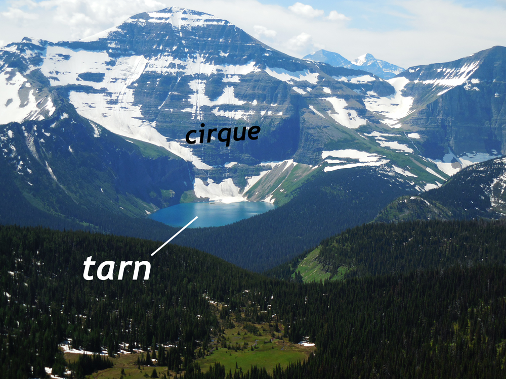
Tarns are glacial lakes that sit at the bottom of a cirque. As glacial ice forms and flows downhill out of the cirque, it moves both down and out, rotating. This “scoops” out the cirque in a way that often leaves a low spot upstream of a threshold. The difference in topography can also be enhanced by the deposition of an end moraine across the edge of the cirque. If this depression in the landscape isn’t well drained, it will act to impound and retain water: a tarn.
Pater noster lakes

Along the course of a glacial valley’s trough-like shape, there are various things that can stop and impound water, most particularly a series of recessional end moraines. Add in a tarn at the top of the valley, and you can have a series of lakes, each connected to the next one downstream by a single drainage stream. In map view, then, these lakes look something like beads on a string, resulting in their distinctive name. To some Catholic geologist, this pattern resembled a rosary, and they were dubbed after the first two Latin words of a common prayer refrain in that faith, Pater noster, which means “our Father.”
Color

Callan Bentley photo
Glacial lakes high in the mountains (close to their glacial source) often have a striking blue color. This is due to suspended fine particles of rock. Glacial erosion generates many sizes of sedimentary particles but when rushing water flows away from the glacial terminus and enters a lake, it keeps silt in suspension, but will leave behind larger particles such as gravel and sand (frequently dumped where the meltwater stream enters a lake, forming a delta).
Peyto Lake in Banff National Park, just north of Glacier in the Canadian Rockies, shows this dynamic well: The upstream-most quarter of the lake basin is filled with an outwash delta, and the lake downstream of that retains a heavy load of suspended silt, rendering it a peacock blue color.
Did I get it?
Glacial sediments and depositional landforms
Glaciers leave their mark on the landscape in many ways. One is through the distinctive striations they scratch into the bedrock as they move.

Photo by Tom Biggs.
Another is the deposition of extraordinarily poorly sorted sediment, called till, and of water washed sediment, called stratified drift. Till forms directly from the deposit of sediment by glacial ice, while stratified drift is the result of meltwater transporting sediment away from the glacier’s terminus, sorting and rounding it along the way.
Here’s an example of till:
Note how this outcrop shows substantial boulders dumped amid much smaller particles, including clay. This same effect can be seen from space, as in this Google Earth view of the area between Sun River Canyon and Augusta:
All the white chunks you see in this Google Maps view are erratics, large glacially transported boulders dumped far from their source outcrops. This broad region covered in erratics indicates it is an area of ground moraine.
Individual cobbles or boulders in till will often show glacial scratches on their surface, as with this example:
The lithology (rock type) of the erratics can be used as a clue to trace the source of the sediment. Where did the glaciers come from? In this case, they are mostly Mississippian limestones, so the adjacent Sawtooth Range of the Rockies (i.e., the mountains around Sun River Canyon) are the source. But not too far from here, a short distance to the northeast, there are erratics with a different character. There, they are made of granite and gneiss and other rocks of the Canadian Shield. This suggests the just northeast of Browning is where the Cordilleran ice sheet and the Laurentide ice sheet met, each delivering their own distinctive populations of erratics as a signature of where they came from.
Did I get it?
Ground moraine, kettles and deranged drainage
Ground moraine is a general term for the collection of landscape features that mark an area of continental glaciation. In addition to erratics, they often show hummocky topography, deranged drainages, underfit streams, and kettles. Let’s now examine each.
Typically in this area, areas of glacial melting are marked with hummocky topography, a characteristic lumpy shape to the landscape, where kettles and other low spots are interspersed with low, erratic-covered hills. Here’s an example from the Blackfeet Reservation, between Browning and Piegan:
It’s hard for water to find its way smoothly downhill amid such an irregular landscape. The resulting drainage pattern is twisted and gnarled, and sometimes called “deranged.” Deranged drainage patterns are a signature of landscapes where the sedimentary deposits and flowing streams have yet to come to terms with one another.
When a lot of till is deposited rapidly as a glacier rots, big chunks of ice break off and are buried or partially buried. When they eventually melt, it leaves holes in the landscape. Sometimes these are large, and sometimes these are small. If the bottom of the hole is deeper than the water table, then they will be expressed as a pond. We call these ponds “kettles.” (Walden Pond in Massachusetts is a famous example.) In the arid conditions of Montana’s high plains, though, the ponds can’t stay wet for long, and the same glacial set-up gets a different expression: it makes salty playas: ephemeral ponds that dry out though evaporation and infiltration. Any minerals in solution end up being precipitated, giving them a white crusty appearance. Here are three prominent examples, just north of the road into Sun River Canyon:
There is no major through-going drainage into or out of these kettles, so they never get these “evaporite” minerals flushed out of them.
Here’s an example of what happens to modern streams running through this post-glacial landscape:
In this Google Map, you can see an “underfit” stream running through a broad glacial outwash valley. Where it encounters a recessional end moraine (horseshoe-shaped feature opening to the northwest), it has ponded, making a moraine-dammed lake (the pale blue region). As the stream flows, it continues transporting sediment. When the current of the stream hits the standing water of the lake, the water’s ability to move sediment decreases dramatically. Sediment is deposited at that point, creating a delta (dark green area with vegetation). Eventually this delta will advance southeast, filling in the lake with sand and mud.
The character of the sediment deposited by the meltwater is different than glacial till. The water is much more effective at teasing out fine particles and dropping larger ones, resulting in better sorting. It also tends to produce layered deposits, which is which the drift, the sediment deposited by outwash rivers, is often called stratified drift.
Did I get it?
Evidence for multiple cycles of glaciation
In addition to till, glacial outwash is another kind of sedimentary deposit that forms downstream of glaciers, as meltwater works through the poorly-sorted till and separates out the finer-grained components from the coarser-grained components. In this outwash setting, stream deposits produce clast-supported conglomerates, like this one:
If the pebbles and cobbles are being dropped from floating icebergs into silty lake sediments, the character of the conglomerate is different: It can be matrix-supported instead:
Lake deposits are dominated by silt (the same “glacial flour” that makes glacial lakes such striking colors when it is suspended in the water column), producing a chalky-feeling deposit.
Callan Bentley photo
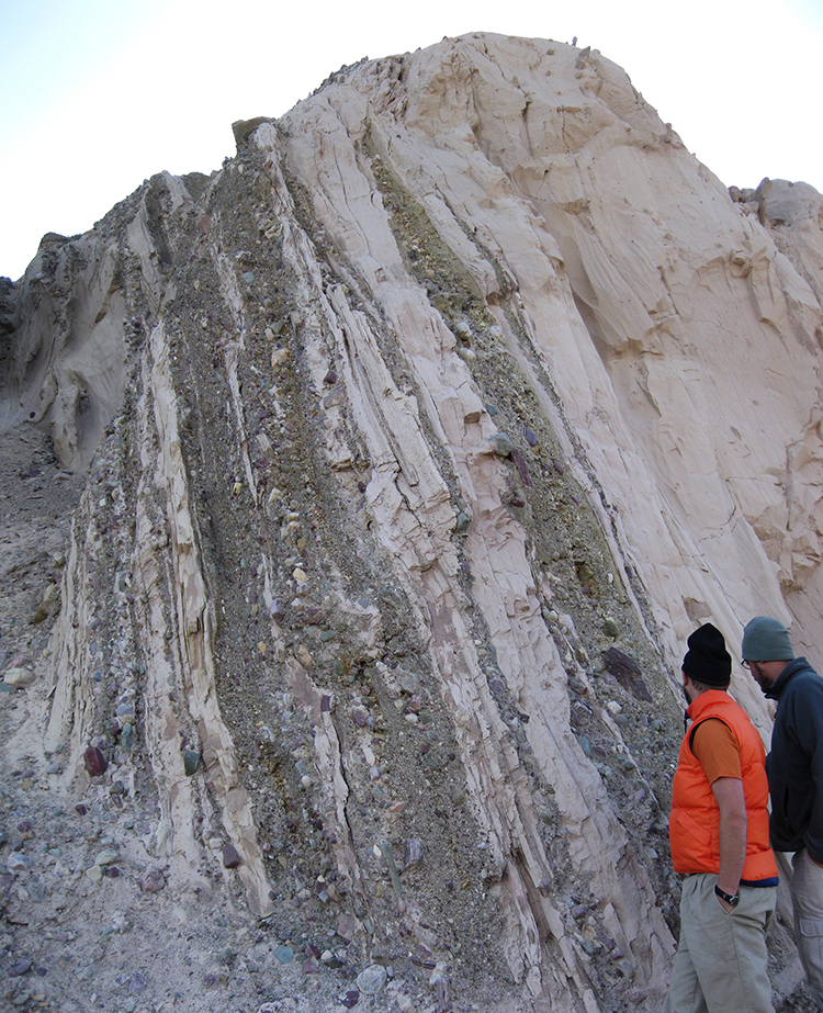
At a set of striking outcrops on the Looking Glass Highway (between St. Mary and East Glacier), there are outcrops of these very young outwash sediments, but with an unusual character: Mostly silt, but also with layers of river gravel and dropstones. The familiar colors of red and green argillite jump out, as well as cobbles of diorite, quartzite, and limestone. It’s a grab bag of Belt rock types, rendered into cobbles and pebbles, and brought eastward out of the park by Pleistocene glaciers.
But here’s the kicker: these deposits of stratified drift are not horizontal. Check out the attitude of the layers here:
That’s quite deformed! Here’s a look at the adjacent outcrop, 10 meters to the south:

Tom Biggs photo
These layers are tilted, and tilted a lot. In fact, they are almost vertical!
How could such a situation come to pass, given that the tectonic compression of the Sevier Orogeny ended tens of millions of years previously? These are young glacial outwash sediments; how could they have been forced into such astoundingly deformed positions, given their extreme youth? This is a puzzle!

Callan Bentley graphic
The answer seems to be that this is evidence for multiple cycles of glaciation in the Glacier National Park region. The compression that rotated these layers was glacial in origin, not tectonic.
Consider the following sequence of steps:
- A glacier deposited an end moraine. It could have been a terminal end moraine (representing the maximum extent of the glacier) or it could be a recessional end moraine (representing some spot where the glacial terminus “paused” for a while, reflecting a balance between inputs and outputs).
- The glacier receded a bit, with a proglacial lake forming between the glacier and the moraine (which acted as a dam).
- Outwash sediments from the glacier entered the lake, including suspended silt (glacial “flour” that settled from the lake) as well as gravel brought in by outwash streams. Icebergs calved from the glacial front floated out into the lake, melting and dropping their internal sediments into the silt on the floor of the lake (dropstones).
- The glacial budget changed again, but this time with inputs exceeding outputs. So the glacier advanced, moving out over the area of the lake and “bulldozing” the outwash deposits, folding and tilting them.
- The glacier finally melts away for good, leaving the deformed outwash sediments high and dry, and available for curious geologists to contemplate… and perhaps even marvel at!
Did I get it?
Bull Lake & Pinedale glaciations in the northern Rockies
On the North American continent as a whole, glaciologists and Quaternary geologists have identified multiple cycles of Pleistocene glaciation. Each cycle consists of an advance of glacial ice southward from Canada into the lower latitudes of the United States, but also from higher elevation mountain regions downhill into lower elevations. The problematic part of this work, teasing out the history of glaciation, is that each new episode of glaciation tends to destroy the evidence of its predecessors as it rolls over the same territory. This means that, with a few exceptions, we only really know “a lot” about the most recent episode of glaciation, and the only older episodes we can see well recorded are those which reached further south (and downhill) than their successors. Those older but more extensive deposits survive only on their uttermost fringes, with any territory later occupied by younger glaciers overprinted.
The major episodes of North American glaciation that have been identified are named after U.S. states: pre-Illinoian (consisting of perhaps 11 separate episodes, though this number is controversial), Illinoian, and Wisconsin. In the Rocky Mountain region, including Glacier National Park, these terms are not applied, as the character of the glaciation we strongly influenced by the mountains, with their high elevations and steep gradients. Most Quaternary glacial geomorphologists identify two principal pulses of glaciation in the Rockies: the Bull Lake glaciation from 200 ka to 130 ka, and the Pinedale glaciation, which spanned from around 30 ka to 10 ka. As such, the Bull Lake correlates with the Illinoian on the continental scale, and the Pinedale is the Rockies equivalent of the Wisconsin glaciation.
The Pinedale is named for Pinedale, Wyoming, where exquisite landforms associated with that glaciation can be found along the southwestern front of the Wind River Range. Consider this gorgeous example of a moraine-dammed lake, for instance:
There are plenty more in the area – Explore for them using this live Google Map, zooming out and panning southward along the mountain front.
Interaction between Cordilleran and Laurentide ice sheets
As alpine valley glaciers extended downhill and eastward out of the Rocky Mountains during the Pinedale glaciation, they spread out into Piedmont glaciers and merged to make a substantial ice sheet. This ice sheet is called the Cordilleran ice sheet, as it was centered on the North American Cordillera (the “spine” of mountains that runs from Alaska to Panama).

The area immediately east of Glacier National Park is interesting because it is where the Cordilleran ice sheet met the continental-scale Laurentide ice sheet. In other words, the bulky maximum extend of the Pinedale glaciation crept out of the Rockies and pressed up against the edge of the maximum extent of the ice sheet from the Wisconsin glaciation. Consider for a moment how Quaternary geologists might determine where this zone of interaction was. What evidence might they search for?
As seen in the preceding examples of till and glacial outwash in the Glacier National Park region, the rock types making up the glacial sediments of the Cordilleran ice sheet must match the source outcrops in the mountains. Similarly, the Laurentide ice sheet brought its own distinct blend of rocks with it, transporting them south out of the Canadian interior. These rocks of the Canadian shield tend to be high-grade metamorphic rocks like gneiss as well as plutonic rocks such as granite. There are no such lithologies present in the Lewis Range or Sawtooth Range, so it stands to reason that, headed east from Glacier, when you run out of Belt and Mississippian carbonate as particles in the local glacial sediments, and start seeing gneiss and granite instead, that’s the indication that you’ve crossed out of the zone occupied by the former Cordilleran ice sheet and into the “continental” signal showing the footprint of the Laurentide ice sheet.
Did I get it?
Conclusion
During the Pleistocene epoch of geologic time, repeated episodes of glaciation dramatically changed the region of Glacier National Park. These flowing rivers of ice carved the deformed Belt and Mississippian bedrock into mountain scenery with new shapes, characterized by U-shaped valleys and spiky peaks and fins of rock. In doing this carving, a tremendous amount of sediment was generated, and that sediment was dumped largely to the east of the park, producing another set of landforms made of till and stratified drift. The Rocky Mountain record of glaciation shows two discernible pulses of ice growth, as well as interaction in the northwest Great Plains with the continental Laurentide ice sheet.
Further reading
Eric Karlstrom (1987), “Zone of interaction between Laurentide and Rocky Mountain glaciers east of Waterton-Glacier Park, northwestern Montana and south western Alberta,” Rocky Mountain Section of the Geological Society of America Centennial Field Guide vol. 2, Geological Society of America, Stanley S. Beus, editor.
National Park Service (n.d.) “Glacial Landforms.” Website.
Also consider reading the Snowball Earth case study in this text “book.”
“How do glaciers move? TIMELAPSE!” (2018) BBC Earth video.