Modified by CB from an original by Frank Ramspott – republication permission currently being requested.
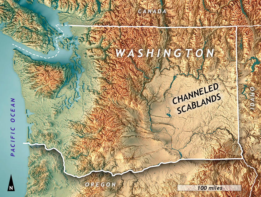
In eastern Washington state, there is a vast landscape with unusual landforms, the Channeled Scablands. Here, a dedicated geologist meticulously documented data that challenged his colleagues to accept a violent flood as a viable interpretation of past events. His discovery contradicted prevailing orthodoxy, but he was ultimately vindicated when another scientist documented evidence of a vast glacier-dammed lake in neighboring Montana.
Uniformitarianism vs. Catastrophism
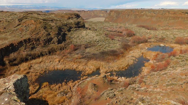
Photo by Pictoscribe, CC-by via Flickr
We have to start our story with the backstory. This was a philosophical debate, the tension between two competing ideas: uniformitarianism and catastrophism.
Before geology was established as a scientific discipline in western Europe in the mid- to late-1700s, the prevailing intellectual paradigm was based on a literal reading of the Bible, specifically the book of Genesis. Many people will be familiar with the story of Noah’s flood, one of many similar flood myths in different cultures. A global flood would be a great catastrophe —indeed, that was the point— and the thinking went that it might be responsible for moving a lot of sediment around from one place to another. Attributing geologic change to a flood (specifically to “The” Flood) was the ideology called catastrophism. This was palatable to those thinkers who anchored themselves firmly in the Christian faith, which was almost everyone in western Europe during the 1700s. Because of this, catastrophism is frequently invoked alongside creationism, the idea of a divine origin for the world. It is a favorite go-to explanation today among young-Earth creationists, those who think the Earth is far younger than most geologists do. For our purposes, the key thing to note is that broadly construed, catastrophism argued that geologic change was sudden and violent.
Public domain via Wikimedia Commons.
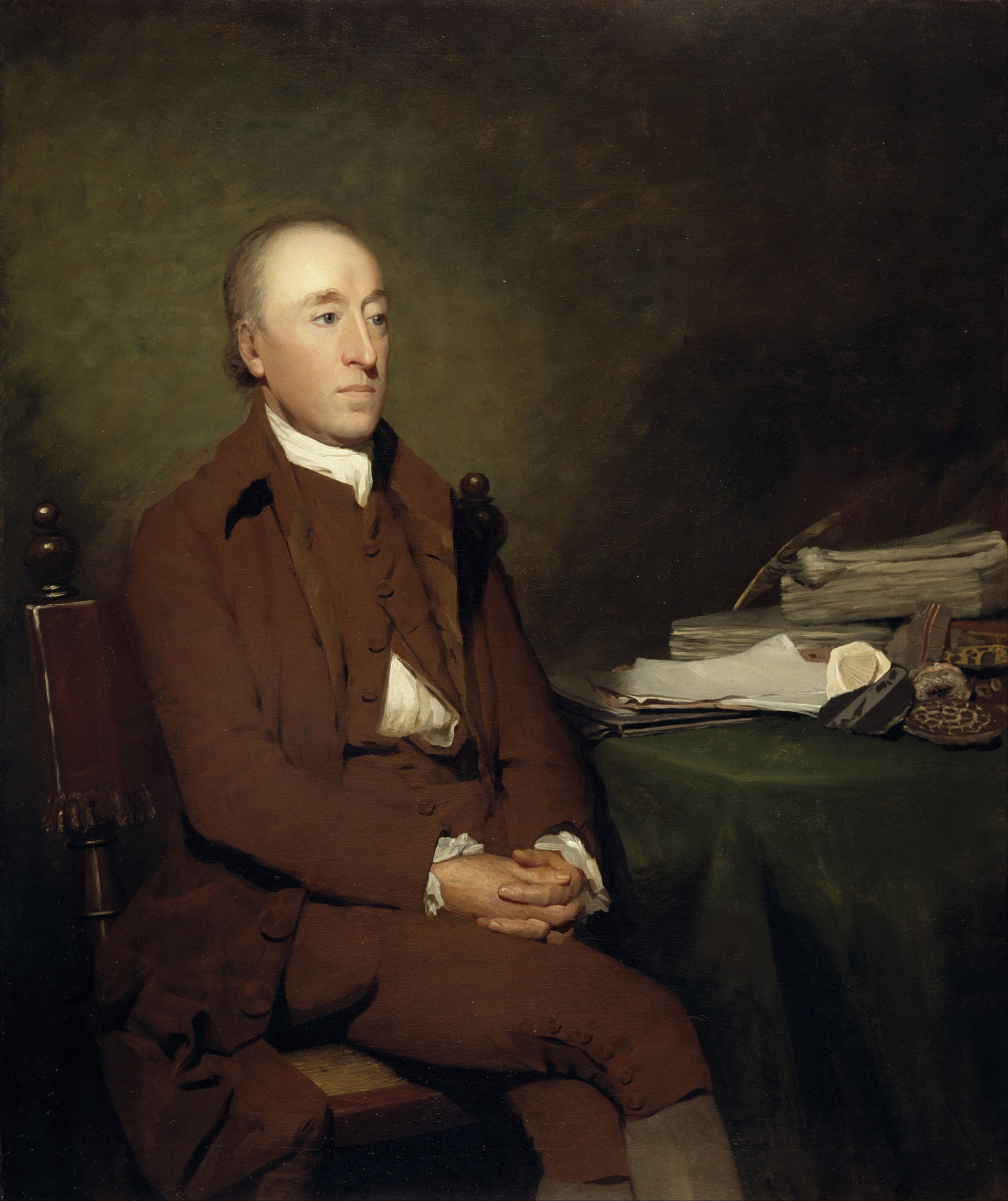
Then came the new discipline of geology. Early geologists found evidence that was inconsistent with all change being catastrophic. Foremost among them was James Hutton, a Scottish intellectual and farmer. Hutton saw the creeks draining his farm turn brown and turbid after a heavy rain, and inferred that some of the soil on his fields was being lost to the sea. He envisioned what must happen to that sediment after it coursed out of sight. When the creek flowed into the sea, that sediment would settle out and make a thin layer over the seafloor. Repeated thousands or millions of times, this simple, inefficient process could eventually denude the land and carpet the bottom of the ocean with vast layers of sediment. He inferred that the many layered sedimentary rocks must have formed in just this way, a little bit at a time, in enormous horizontal sheets. The present day’s slow and gradual change wasn’t just the ‘calm after the storm Flood,’ it was the way that change had happened over eons, producing and erasing the geologic record through slow, gentle, gradual processes playing out over vast amounts of time. Repeated cycles of uplift and erosion at a given location were interspersed with times of deposition, burial, and lithification.
Callan Bentley photo.
Taking the next step from this insight, Hutton articulated the significance of the angular unconformity at Siccar Point, Scotland, where two packages of stratified sandstone are juxtaposed at two different orientations. Hutton realized that it would take six steps to make this distinctive outcrop: (1) deposition of gray mud and sand strata horizontally on the seafloor, (2) lithification of those muddy sands into graywacke followed by rotation of the layers into a vertical position, (3) erosion of some of those layers — presumably above sea level where erosion is easiest to accomplish, (4) a new round of deposition of horizontal sediment, this time highly oxidized red mud and sand — but still horizontally, (5) lithification of those new sediments into solid sandstone and shale, followed by rotation of those layers slightly, and (6) modern erosion of both rock types. That’s a lot of detail to extract from one outcrop, and Hutton reckoned that going through all those steps must have taken a good long while. He thus established that geologic time must be fairly vast, fairly “deep.” Siccar Point holds a special place in the hearts of geologists, since it was the place where “deep time” was first fully appreciated.
Since Hutton’s insight, geologists have successively pushed our sense of the age of the world back further and further. William Whewell dubbed Hutton’s big idea uniformitarianism, and Charles Lyell promulgated uniformitarianism far and wide in his best-selling textbook The Principles of Geology. Charles Darwin read Lyell’s book, and used this newfound sense of an immensely old Earth as a necessary pre-condition for his own ideas about natural selection driving evolutionary change in living organisms.
Photo: Michael John Cheadle, University of Wyoming
Later still, the discovery of radioactivity finally gave geologists a “clock” they could use to quantitatively determine when certain minerals formed. Before this technique was a few decades old, it had put an age on the planet that exceeded a billion years. Modern estimates place the planet’s formation at 4.566 Ga: plenty of time for slow, gradual change to dominate the geologic record. Uniformitarianism now had all the wiggle room it needed to explain Earth history. Geologists were now almost unanimously uniformitarian in their outlook. Catastrophic hypotheses smacked of young-Earth creationism, and that was plainly unacceptable to professional geologists. (An excellent exploration of flood mythology, creationism, and uniformitarianism may be found in the book The Rocks Don’t Lie, by David Montgomery.)
This was the situation that J Harlen Bretz walked into, and he had some unwelcome news for his colleagues: he had found geologic evidence of an actual catastrophic flood.
J Harlen Bretz
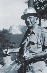
J Harlen Bretz is the hero of this story, a geologist who followed the evidence in the landscape to his own conclusion, even though it flew in the face of the prevailing orthodoxy: uniformitarianism. He began his career as a high school teacher in Seattle, but became interested in geology, and soon quit his job so he could pursue graduate school. With a PhD in hand, he began studying a region in eastern Washington state where the farming was so poor that local farmers had dubbed it the “Scablands.” After a spell working back in Seattle at the University of Washington, Bretz settled in at his alma mater, the University of Chicago, in Illinois. Summer field campaigns brought him back repeatedly to the Scablands, where he put his students to work mapping the strange landscape, which was unlike anything they had ever seen.
Channeled Scablands geomorphology
Photograph by Lynn Suckow, CC-by via Wikimedia.
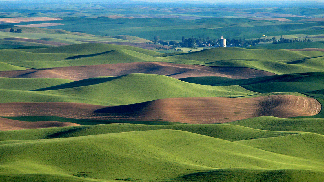
The area of the Scablands has a three-part geological history. The third part is the one that Bretz elucidated. We will get to that in a moment, but here’s what came first. The area is part of the Columbia Plateau, a vast flood basalt province that mostly formed between 17 Ma and 15 Ma. Mafic lava flows are stacked up like a batch of pancakes. On the very top (like powdered sugar on the pancakes?) is a layer of loess, which is windblown silt. The loess makes for very fertile soils, and it makes for a region of prime agricultural land called the Palouse.
But as we shall soon see, the nurturing soils of the Palouse (and much of the basalt they overlie) were blasted away by the Missoula floods. That’s the third part of the region’s geologic history; the one discovered by J Harlen Bretz. So what did Bretz see instead of the usual basalt and loess? His great contribution to geology was meticulous documentation of a series of superlative landforms. The first of these to consider are the coulees.
Coulees
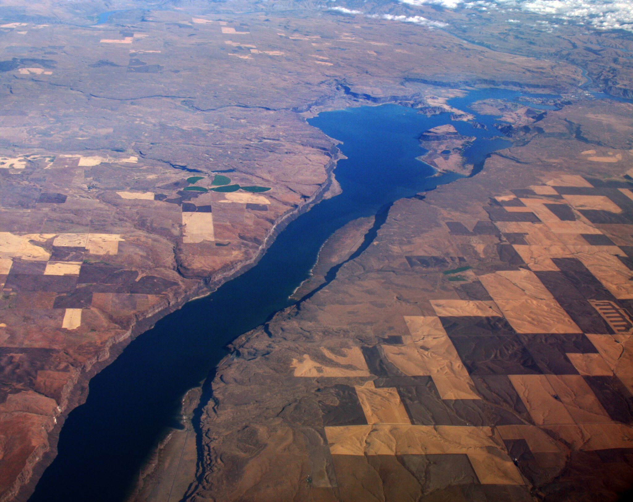
Photo by Doc Searles, CC-by license via Flickr.
Local place names are one of the delights of traveling to different parts of the world. For instance, a small current of running water might be called a stream, a creek, a run, or a kill, depending on what part of the country you find yourself in. An amphitheater-shaped glacial valley head might be called a cirque, a corrie, or a cwm, depending on whether you’re in the Alps, Scotland, or Wales. A valley may be a hollow (or “holler”), a draw, an arroyo, gully, a ravine, a dell or a glen.
In eastern Washington state, some valleys are called coulees. These are not the classic V-shaped valleys with a stream running along the bottom, however: they are rectangular or “boxy” in cross-section, thanks to the architecture of the basalt lava flows they cut through.
As Bretz explored the coulees of eastern Washington, he noticed several things: (1) many of the coulees were bone dry, despite presumably having been formed through erosion by running water, and (2) there was a pronounced common orientation to the coulees, trending from Spokane in the northeast off to the southwest. Bretz and his students documented these landforms across the Scablands, and when presented in a map, the pattern is striking:

The coulees branch and merge, wrapping around isolated mesas of basalt and loess. This is why Bretz dubbed the region the Channeled Scablands. The “Channeled” part of the name refers to these coulees.
Dry waterfalls
Sometimes the coulees featured dramatic downward steps along their downhill course. These “steps” would be dramatic waterfalls if water was flowing over them, but instead they are bone dry, often with dramatic plunge pools below the cliffs. The GigaPan below shows one of these sites; explore it for a sense of the tremendous scale of these features.
Bill Richards GigaPan
The Dry Falls complex separates upper Grand Coulee from lower Grand Coulee. It is 400 feet high and about three miles wide. That is about ten times the size of modern Niagara Falls in New York.
Eroding out these downstream channels and plunge pools would have produced a lot of new clastic sediment, principally basaltic gravel. The size of the clasts of basalt varied from “normal” sizes you could hold in your hand, to truly jawdropping monsters.
Big boulders
The biggest boulders are most worthy of our attention, because they establish an upper bound on how powerful a current of water it must have taken to move them. One giant is found near Soap Lake, Washington, part of a vast deposit of gravel called the Ephrata fan. It is a substantial distance from its source outcrop, but it is Columbia River basalt, so it seems unlikely to have been ice-rafted.
Check it out:
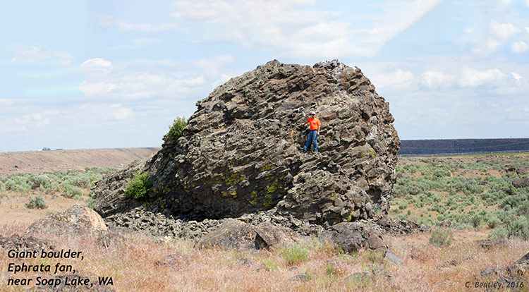
Callan Bentley photo.
That is an enormous boulder, and it must weigh a lot. Though glaciers regularly transport erratics of this size, there is no evidence that glacial ice ever flowed over this part of the country. The nearest glaciers were dozens of miles off to the north… we’ll come back to them in a moment.
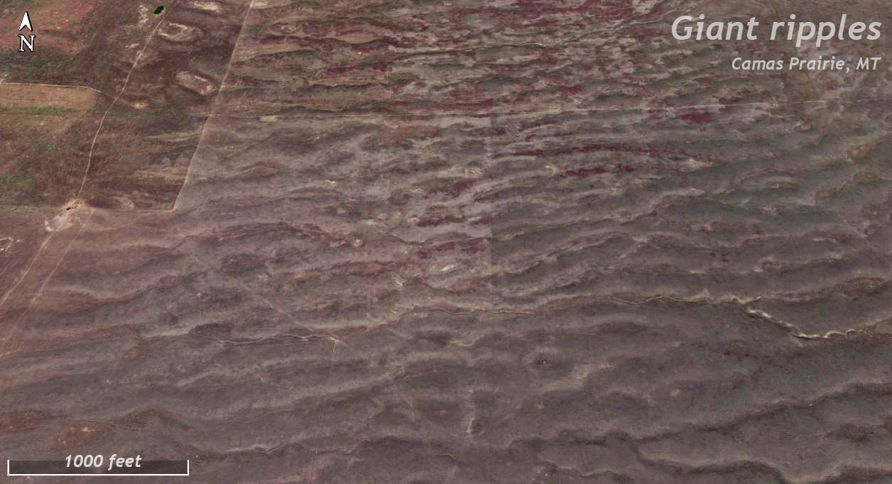
Giant ripple trains
Callan Bentley photo
As if this weren’t enough, the Channeled Scablands also included vast trains of giant ripples – like the cm-scale ripples that form in sand on a stream bottom, but these were just gargantuan. Each ripple stood 35 feet tall, with a wavelength of 300 feet between ripple crests. They were arranged in large clusters called “trains.” Over one hundred giant ripple trains have been documented in the region.
Google Earth image.
Consider this scene from Google Earth, which shows a satellite view of the giant ripples that cover the floor of the Camas Prairie in northwestern Montana. Many places in the Channeled Scablands also feature vast arrays of these ridges. To make ripples this large out of such large sediment would seem to require a lot of very fast moving water. At least, that’s how it seemed to Harlen Bretz.
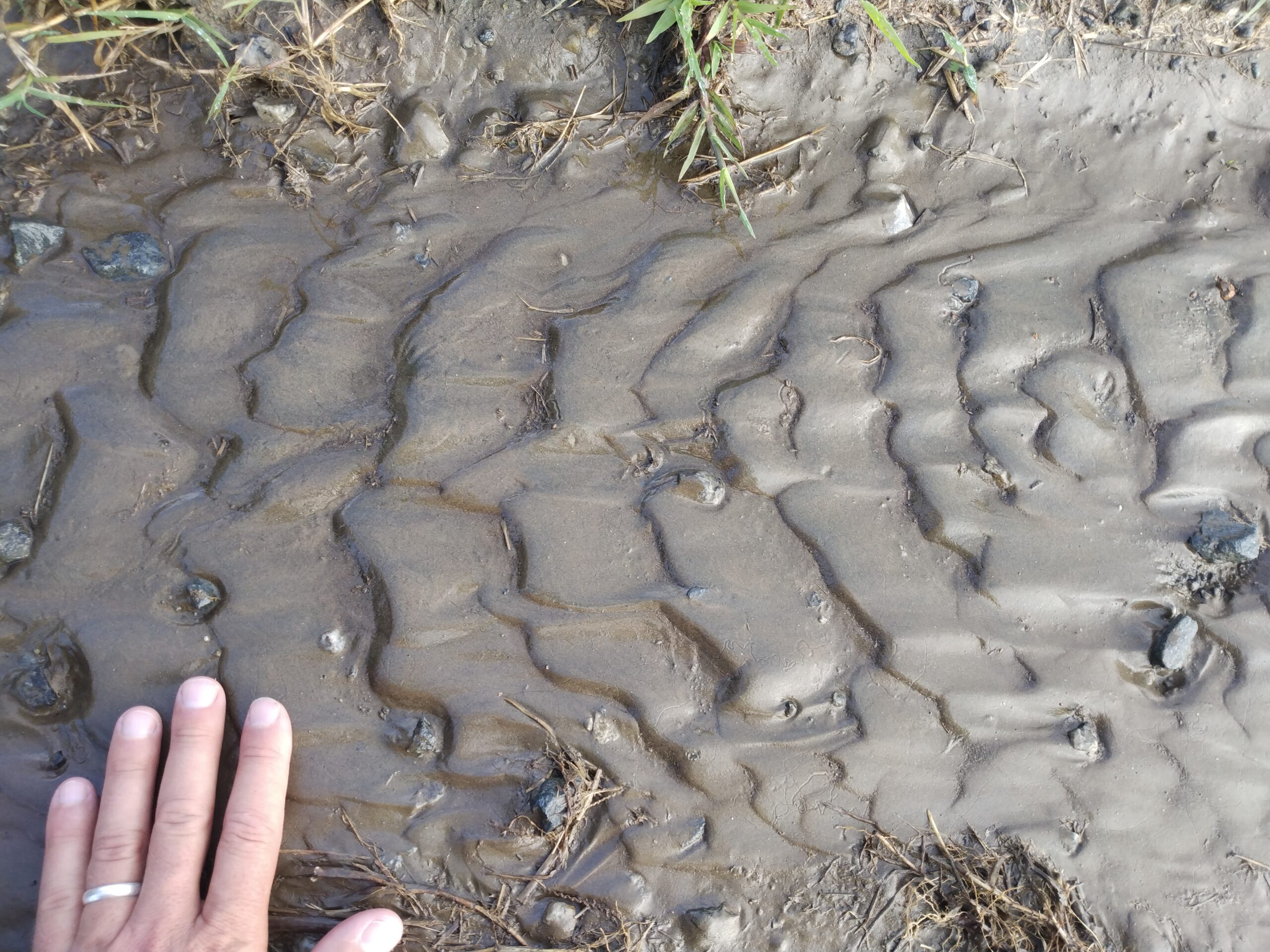
Instead of being made of sand, like normal ripples, these giants were constructed from boulders and cobbles – sedimentary particles that take vastly more energy to move than sand grains. Here’s a cross-section through one:
Callan Bentley GigaPan
It would be difficult to identify that as a ripple from ground level! This is a case when backing away from the subject yields the critical perspective that gives insight.
Now, let’s zoom out again, and see what these ripples look like from far away. Compare the giant current ripples in the GigaPan below (tan rolling hills above the modern river) to the sheer cliffs of basalt that define the edges of the Columbia River’s gorge:
Callan Bentley GigaPan
Potholes
Callan Bentley photo.
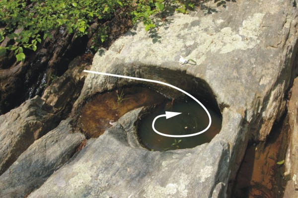
When fast-moving water flows over a tough bedrock surface, drag slows the current immediately adjacent to the rock. Meanwhile, less-impeded water flows freely in the main channel, and that sets up a differential rate of flow. Spiral shaped vortices develop, and if these vortices of water have sediment suspended within them (such as sand and silt, under normal circumstances), then they can focus abrasion on the bedrock at the point of the vortex. This creates a cylinder-shaped hole to be bored into the rock: a pothole.
In the Channeled Scablands, there are potholes, too – as you might expect from such violently-rushing waters. The difference between the “normal” situation and that found in eastern Washington is merely size. The potholes in the Channeled Scablands can be a quarter-mile in diameter. Here’s one such location, Potholes Coulee, shown in Google Maps. Zoom in and explore the substantial round holes in the ground. These are potholes – but incredibly enormous potholes!
In summary, Bretz had documented a suite of features that were both very unusual and could all be explained by a common hypothesis. The dry coulees and falls of raw basalt, lacking the mantle of fertile Palouse loess, the giant boulders, potholes, and ripple marks — they all suggested the same thing: the Channeled Scablands had been ravaged by a giant flood beyond anything recorded in human history.

NPS photo
Bretz thought the flood might have been similar to big glacial outburst floods documented in Iceland, when volcanic activity melted a glacier from beneath. These jökulhlaups (“yokel-ahps”) were impressive indeed, though not quite on the same scale as what Bretz envisioned for the Channeled Scablands. The jökulhlaups were powerful, but perhaps not quite “catastrophic.” Bretz had cut his teeth working on the glacial geomorphology of Puget Sound, and knew that there was substantial evidence for glaciers not too far away – up by Spokane. Could a jökulhlaup have carved the Channeled Scablands?
My Multiple Choice Quiz
Bretz floats his hypothesis
In 1923, Bretz finally put his audacious ideas into print. Like any careful scientist, he considered potential objections and attempted to disarm them before they could be deployed. He knew what he had to say was going to be controversial, because a giant flood was anathema to the uniformitarian paradigm that governed professional geoscience. If “the present is the key to the past,” Bretz had a big issue: A flood of the size he was proposing had never been seen in human history. He was venturing into catastrophist terrain! But what choice did he have? He couldn’t account for the singular collection of landforms in the Scablands any way except for the big flood hypothesis.
It should probably be noted here that Bretz’s proposed flood was very much a regional (not global) affair. It would be a big mistake to leap from the conclusion that there was a big flood in the Channeled Scablands during the Pleistocene to anything on the continental or planetary scale. Bretz’s flood was big, but it wasn’t that big.
In January 1927, Bretz formally presented his idea that the Channeled Scablands were best explained by an enormous flood. He spoke at the Geological Society of Washington (that’s D.C. this time, not the state), and it was a legendary case of scientific ambush. The professionals there chewed him up and spit him out, especially those who were older and professionally established, teaming up to vocally attack his ‘flood’ interpretation. But sitting quietly in the room was J.T. Pardee, a young and thus relatively vulnerable new recruit at the USGS. Pardee didn’t want to run the risk of irritating his new colleagues and superiors by speaking out. But he knew that something no one else did – just to the east was a glacial lake that could have provided sufficient water to supply Bretz’s flood: Glacial Lake Missoula.
Glacial Lake Missoula
Above the town of Missoula, Montana are a series of subtle notches in the hillside. Like the giant ripples we mentioned earlier, they are hard to see if you’re standing on them. They show up most photogenically when lightly dusted with snow, and viewed from high above.
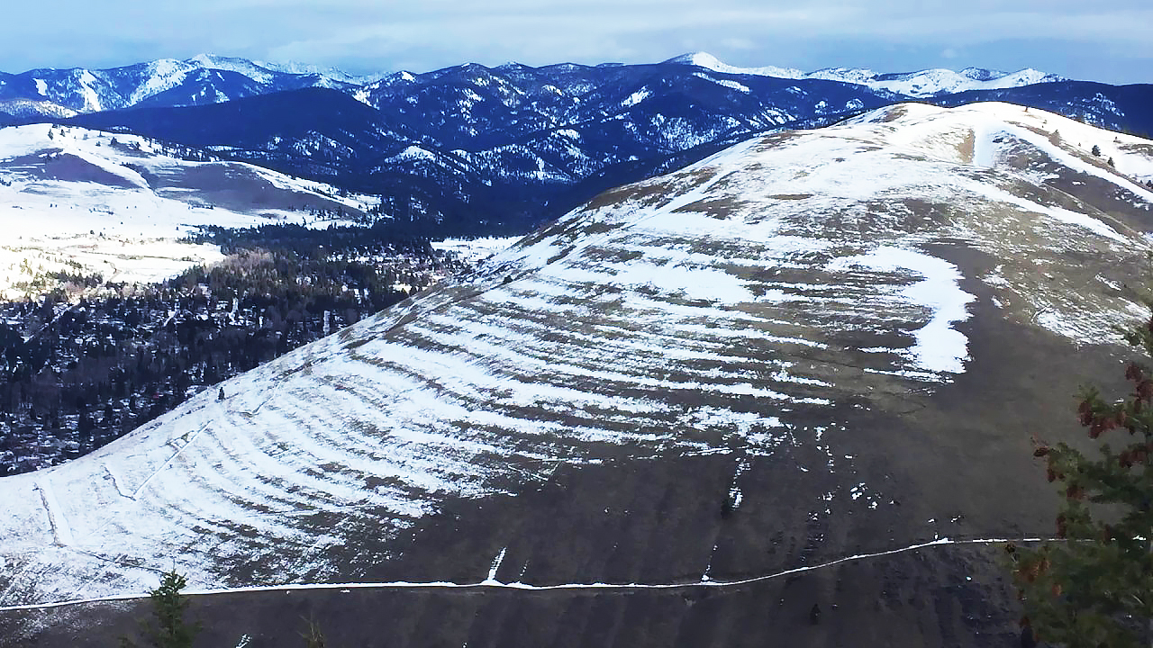
Image modified from a still from a video produced by the Montana Natural History Association.
Each of these notches is perfectly horizontal, wrapping around the landscape without deviating in elevation even by an inch. Thomas Crowder Chamberlin noted these in 1886, correctly interpreting them as ancient lakeshores by comparing them to what he had read of the so-called “Parallel Roads” of Glen Roy, Scotland. The idea is that waves on the shore of a now-vanished lake must have lapped against the hillside with sufficient vigor to etch out a notch. The valley was apparently filled by lakes of many different levels in the past. These lakeshores are called strandlines.
Modified by CB from an original by the Montana Natural History Association.
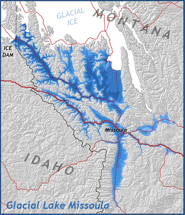
The Missoula strandlines imply an ancient lake once filled the valley where today the University of Montana is situated adjacent to the Clark Fork River. What formed that ancient lake? J.T. Pardee thought he knew. Pardee was a native Montanan who pursued a career doing geology for the United States Geological Survey. He traced out the strandlines across the landscape, heading north and downstream along the Clark Fork River. His mapping led him to Sandpoint, Idaho (on the Idaho/Montana border), where there was no evidence of a landslide dam, nor a lava dam, nor any other kind of dam that was still there. What impounded the Clark Fork to make the lake, then? If the Parallel Roads of Glen Roy were to act as any guide, perhaps it was glacial ice that dammed the river.
Pardee postulated that the Purcell Lobe of the great Laurentide ice sheet nudged south into the valley and made an ice dam 23 miles (37 km) wide, spanning the relevant drainage, and rising to half a mile (0.8 km) high above the valley floor. The impounded waters of the Clark Fork River pooled to make Glacial Lake Missoula. This huge glacial lake extended up to 200 miles upstream from the ice dam.

Callan Bentley photo.
In places, the lake may have been as deep as 200o feet. At the bottom of this vast volume of water, depositional conditions appeared calm. In many places, laminated strata record lake-bottom sedimentation that alternated rhythmically between silt and clay. These regular oscillations are interpreted as varves.
Why did the dam eventually break? The answer lies with the fact that ice is less dense than liquid water. So when the voluminous waters of the lake got deep enough, this giant ancient lake simply floated its icy dam away. Released by the now-absent dam, where did the waters of Glacial Lake Missoula go? In a word, downhill.
The path downhill — to the Pacific Ocean, via the Columbia River — ultimately led across eastern Washington. Released in an instant, the violent draining out of the lake unleashed 500 cubic miles of water across the landscape. With a discharge estimated at 60 times the size of the Amazon River, the flood waters gouged in and spread out, and reconvened, and pushed boulders, deposited giant ripples, tumbled over waterfalls, and drilled out massive potholes.
And then the ice flowed back in, rolling over the same ground, backing up the same river again, regenerating a new iteration of Glacial Lake Missoula, and etching a new strandline into the surrounding valley walls.
This 2015 video, by Nick Zentner and Tom Foster, shows many of the key details:
Catastrophes aren’t against the rules
So J Harlen Bretz ended up having an impact on geologic thinking that went far beyond the dissected canyons of the Columbia Plateau. He pushed the limits of our imagination, forcing geologists to consider that maybe they hadn’t seen it all. Nature had tricks up her sleeve that might be powerful, singular, and of vital importance, but these processes are still well within the bounds of the laws of physics. If we want to be good at interpreting the past, we have to consider the potential for unique violent events to periodically occur. If not for Bretz, would Walter and Luis Alvarez have dared to invoke an extraterrestrial impact for the end-Cretaceous extinction event? Would the Snowball Earth hypothesis ever have been proposed?
 In 1979, the Geological Society of America (GSA) unambiguously celebrated Bretz’s willingness to follow the field data where it led him, even though that path led to the conclusion of a vast catastrophe well beyond the human experience. In accepting GSA’s Penrose medal, Bretz humbly summarized, “Perhaps I can be credited with reviving and demystifying legendary catastrophism and challenging a too rigorous uniformitarianism.”
Further reading
David Alt, 2001. Glacial Lake Missoula and its Humongous Floods, Mountain Press, 191 pages.
Vic Baker, 2022. “J Harlen Bretz (1882–1981): Outrageous Geological Hypothesizer.” GSA Today, May 2022, p. 50-51.
Callan Bentley, 2016. “Flood deposits of Glacial Lake Missoula outburst floods,” Mountain Beltway blog.
J Harlen Bretz, 1923. “The Channeled Scablands of the Columbia Plateau,” Journal of Geology, Nov.-Dec. 1923, p. 617-649.
“Mystery of the Megaflood,” NOVA, Public Broadcasting System. Television broadcast, 2005.
“The Great Ice Age Floods,” video by Washington State University (10 minutes).
Scott Johnson, 2014. “The Scablands: A scarred landscape as strange as fiction.” Ars Technica.
David Montgomery, 2013. The Rocks Don’t Lie, W.W. Norton, 320 pages.
J. T. Pardee, “Unusual currents in Glacial Lake Missoula, Montana.” GSA Bulletin 1942, 53 (11): p. 1569–1600. doi: https://doi.org/10.1130/GSAB-53-1569
John Soennichssen, 2008. Bretz’s Flood. Sasquatch Books, 286 pages.
John Soennichssen, 2009. “Legacy: J Harlen Bretz (1882-1981),” University of Chicago Magazine, Nov-Dec 2009.