The History of the San Andreas Fault and the Basin and Range
At the end of this chapter, students should be able to:
- Explain the events that lead to the Basin and Range and San Andreas Fault System
- Identify the physiographic features of the Basin and Range, horsts and grabens
- Describe the extensional tectonics and volcanism of the Basin and Range
- Explain the complex tectonics of the modern San Andreas Fault System and its development
Introduction
What happens when a mid-ocean ridge is subducted?
The basics of plate tectonics are essential to introductory geology. Two essential aspects are the idea that ocean basins grow via seafloor spreading at mid-ocean ridges and close via subduction. But what happens when these two processes combine? The answer to this is complicated, and is best exemplified by exploring the Cenozoic tectonic history of western North America. This was the first place on Earth where this process was understood, and it is rare enough that not many examples of this can be clearly described in the geologic record.

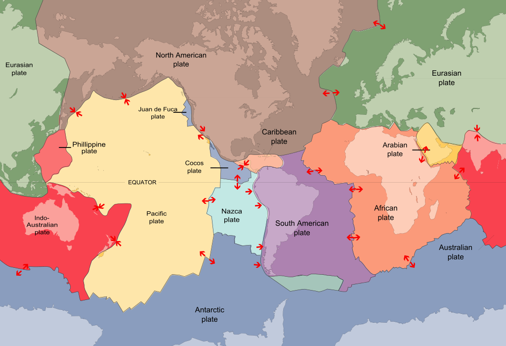
In the Mesozoic, the west coast of North America was dominated by subduction. This led to the Nevadan, Sevier, and Laramide orogenies. The last of these, the Laramide orogeny, was typified by flat-slab subduction. The reason the subduction was flat was that the subducting plate (called the Kula Plate and the Farallon Plate) was hot and young. The subduction zone was close to the mid-ocean ridge, and therefore, the plate was newly formed and still hot from mid-ocean ridge processes. As the plate subducted, the warm temperature lowered its density: warm rock is less dense than cold rock. It was buoyant, making the subduction happen with a shallow angle. Eventually, the mid-ocean ridge itself was subducted, starting around 30 Ma. This event caused two important tectonic features to form: the San Andreas Fault System and the Basin and Range Geologic Province.
Basin and Range
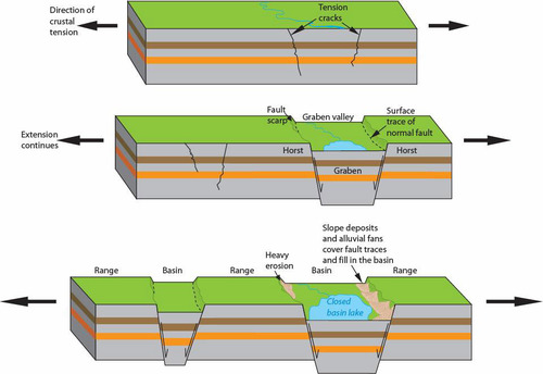
The Basin and Range is a singular geologic province that covers a large portion of the southwest United States and western Mexico. It is probably the best modern example of a wide rift; a continental divergent boundary where the deformation is spread out. Unlike typical (narrow) rifts, like the East African Rift, where the normal faulting due to tensional stresses related to rifting creates a central graben, wide rifts distribute the faulting over a series of horsts and grabens.
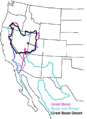
Note that the Basin and Range is different from the Great Basin, which is defined as an area of drainage basins that do not flow towards the ocean but drain internally. The Great Basin is within the Basin and Range, and is made up of the northern arm of the Basin and Range geologic province.
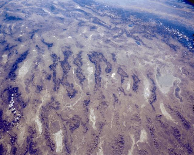
Wide rifting is the cause of the famous Basin and Range physiography: seemingly endless north-south trending mountain ranges bound by north-south trending valleys. Nevada, which is entirely within the Basin and Range, is actually the most mountainous state in the U.S. This is not because it contains the tallest mountains, but because it contains the most mountains. Each of these mountains are bound by normal faults.
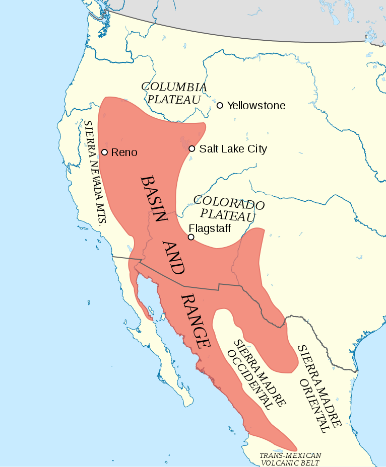
This faulting has doubled the width of the state of Nevada over the last 50 million years. Most of the faults in the Basin and Range are either inactive in the modern day or have a low level of activity. Only the normal faults toward the eastern (e.g. Utah’s Wasatch Fault near Salt Lake City) and western (e.g. eastern Sierra Nevada faults in eastern California) extremes are highly active.
The faulting that started the Basin and Range is complex and not very uniform. In some places, extension started before 55 million years ago, and in some places, it is still active, as mentioned above. However, the majority of the extension occurred around 20 ±10 million years ago. The extensional provinces in the northern part of the Basin and Range started generally earlier, while the southern portion (especially south of 40° north latitude) mostly started later, around 30 million years ago. On any single extensional fault system, it rarely lasted more than 10 million years (Axen el al., 1993).

Another important side effect of Basin and Range extension is heat. A thin plate after stretching means an easier time for upwelling material in the asthenosphere to come up to the surface. This is shown in very high heat flows in the Basin and Range area. Even today, 98% of the geothermal electricity in the United States is produced in Basin and Range states, with California and Nevada being the most productive.
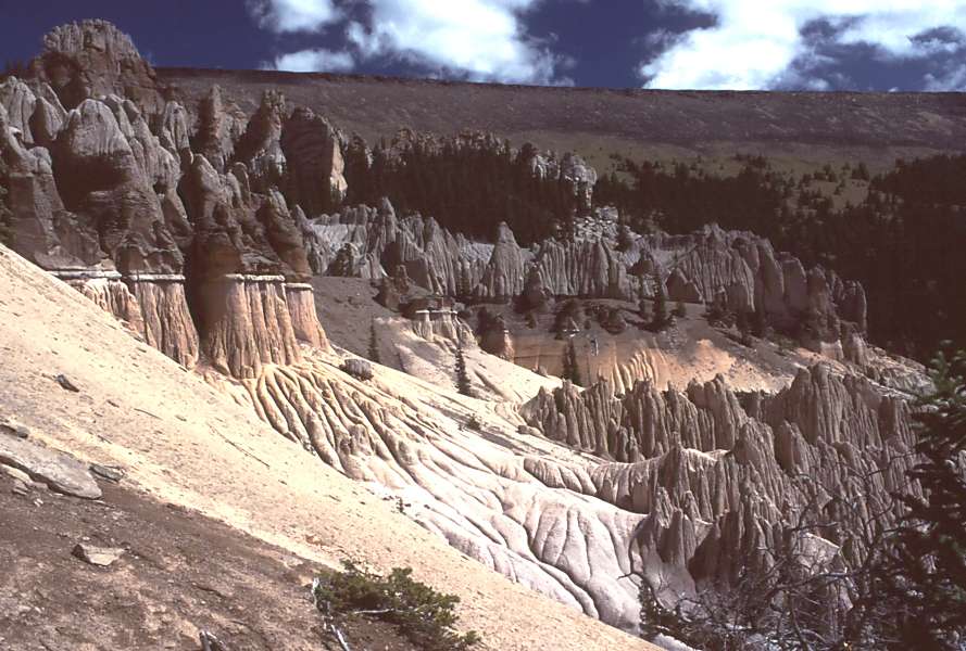
Related to heat is the extensive volcanism across the Basin and Range. The details of how this volcanism occurred is interesting, especially since the preceding Laramide Orogeny is noted for lacking volcanism. The details are debated, but one way or another, subduction stopped, and a ‘hole’ developed in the shallowly-subducting slab which allowed material to come up from below. This event, known as the Mid-Tertiary Ignimbrite Flare-up, started in two swaths, one in Washington and Idaho at about 54 Ma, another in Arizona/New Mexico near the US border with Mexico at 43 Ma. The northern branch of volcanism moved south, and the southern branch moved north, converging near Las Vegas at 21 Ma (Humphries, 1995). This period is noted for producing gigantic explosive eruptions, including some of the largest ever known on Earth, arnd are recorded in extensive tuff deposits. Some of these eruptions are more than 5000 times volumetrically larger than the May 1980 Mt. St. Helens Eruption.
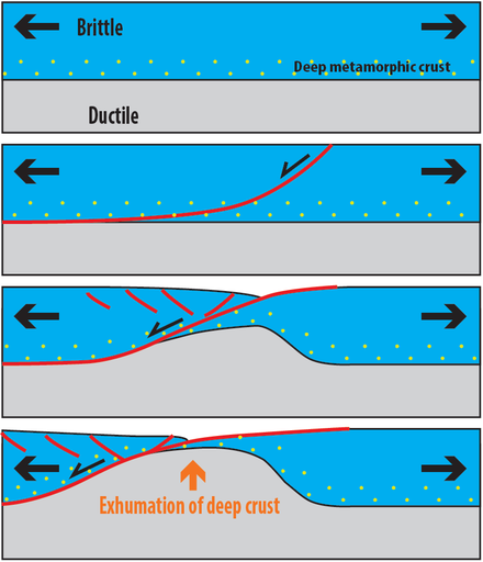
The importance of the Basin and Range to geology is vast. Not only did the extension cause many sedimentary formations, fossils, and resources to be exposed and easier to find, it also helped in the understanding of normal faulting. Two important and related features were first recognized as a result of studying Basin and Range extension: the detachment fault and the metamorphic core complex. Detachment faults, also called low-angle normal faults, were very controversial when they were first described. Most normal faulting occurs at high angles, more than 30° from horizontal, typically around 60°. These faults either started at high angles and rotated to lower angles with extension or form at low angles, which pushed the known limits of rock mechanics at the time. Some geologists and geophysicists felt that the detachment fault could not exist! But over the years, more and more evidence led the entire community to accept these faults, with examples found across the world and on the ocean floor. Near mid-ocean ridges that have a higher spreading rate than their ability to produce magma to form the plate, detachment faults have been known to form, like what is happening in the southwest Indian Ridge near Madagascar. There is even evidence of active detachment faults in Papua New Guinea, which was a hole in the theory previously.
Movement and detachment faults also cause the formation and exposure of metamorphic core complexes. These are places where the large amounts of extension (dozens of miles in places) has allowed deep crustal rock to bulge ductilely toward the surface. The detachment in these cases marks a boundary between highly different rocks: deeply seated, highly metamorphosed basement rocks in the footwall separated by more brittlely-deformed tilted rocks of the hanging wall. Through progressive deformation, the deep rocks ‘pooch upward’ and enter the brittle regime. Signatures of depth, such as mylonite, are overprinted by signatures of shallowness, such as brecciation. Perhaps the best studied and understood detachment fault and metamorphic core complex is in the Whipple Mountains near the border of California and Nevada (one of the ranges of the Basin and Range). Another example include the Black Mountains near Death Valley.

Extension in the Basin and Range has two commonly-cited causes, which may in themselves be at least somewhat related or both occurring at the same time. One cause, which is partially favored as an explanation for earlier extensional provinces in and around Idaho, is extensional collapse. Starting in the middle Mesozoic, the western edge of North America had been experiencing compressional forces due to subduction and terrane accretion. This resulted in the Nevadan, Sevier, and Laramide Orogenies. By 60 Ma, there was a decrease in this compression, with a complete reduction in this force starting 30 million years ago. So many mountains had been built by thrust faulting over this time, and the lithosphere was overthickened. When the forces that built these mountains finally subsided, the topography was allowed to ‘relax’ and part of the crust spread out and thinned, causing at least some of the Basin and Range extension. One big piece of evidence that backs up this model is reactivated structures. These are found all over the west as former thrust faults turned into normal faults upon the transition to extensional tectonics.
San Andreas Fault System
The other cause of extension in the Basin and Range has to do with the creation of the San Andreas Fault System, a complicated but vital piece of the story in understanding the modern plate boundary between the North American and Pacific Plates.
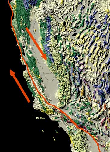
In 1970, still in the infancy of the development of the theory of Plate Tectonics, Tanya Atwater published a paper that explained the newly-discovered magnetic striping in the ocean crust off of the northern California coast. She used the offshore striping patterns in the ocean crust to reconstruct onshore tectonic history. Analysis of the striping implied that a significant event occurred around 30 million years ago: the mid-ocean ridge between the Pacific and (now mostly subducted) Farallon Plates started to subduct. Original Farallon Plate subduction had a convergent motion with respect to the North American Plate. However, once the mid-ocean ridge began subducting, the relative motion of the plates changed direction. This is because the new plate motion was between different plates, namely the North American and Pacific plates. The relative motion was no longer convergent, but instead mostly transform, with the Pacific Plate moving northwest with respect to the North American Plate. This change in transform motion started to form a strike slip fault at the plate boundary. This would eventually become the San Andreas fault system.
The current motion, and most likely motion in the past, is not exactly parallel to the fault system itself. There is a divergent component to the motion, and that divergent motion might be at least somewhat responsible for Basin and Range extension, particularly after 30 million years ago. It is also responsible for the opening of the Gulf of California (rifting of the Baja California peninsula from the mainland of Mexico) and the more than 90° rotation of the Transverse Ranges in Southern California (Ingersoll and Rumelhart, 1999). The video above, illustrated by Tanya Atwater, shows both of these events, in addition to the widespread extension of the Basin and Range, especially in Nevada.
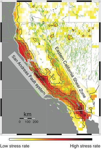
The San Andreas Fault, at least the current, modern one, has not been the only transform boundary that has existed in this location. In the southern section, there have been at least two previous iterations (Powell and Weldon, 1992). More importantly, a ‘new’ San Andreas appears to be forming in eastern California and western Nevada. Called the Eastern California Shear Zone and Walker Lane Fault Zone, these are just part of the reason that the San Andreas Fault proper only accounts for about 75% of modern plate motion. The other 25% is spread over many different faults, including the faults in this probable future version of the plate boundary. This zone is responsible for famous and large earthquakes like the 1872 Mw ~7.6 Owens Valley Earthquake, 1992 Mw 7.5 Landers Earthquake and the 2019 Mw 6.4&7.1 Ridgecrest Earthquakes.
Did I Get It? – Basin and Range/San Andreas
Final Thoughts
For beginning geology students on the west coast of North America, the seemingly simple question “What plate boundary is on the western edge of the continent?” is a difficult one to answer. In California, the San Andreas Fault is the plate boundary, running east of Los Angeles and west of San Francisco, but in actuality the plate boundary is diffuse and spreads as far east as Salt Lake City, Utah as part of the Basin and Range. To the south, the San Andreas blends into a series of faults, like the San Jacinto Fault, and it eventually turns into a mid-ocean ridge as Baja California has rifted away from Mexico and become a peninsula. North of San Francisco, near the town of Eureka and Cape Mendocino (the westernmost part of the state), the plate boundary makes a westward turn into the ocean, ending the San Andreas Fault and transitioning into the Mendocino Fracture zone and the southern boundary of the Juan de Fuca Plate, a residual piece of the Farallon Plate. North of Cape Mendocino, the plate boundary between the Juan de Fuca and North America is convergent, forming a subduction zone. This stretches toward British Columbia, forming famous volcanoes like California’s Mount Shasta, Oregon’s Mount Hood, and Washington’s Mount St. Helens and Mount Rainier. In Canada, north of the Juan de Fuca Plate, the boundary between the North American Plate and the Pacific Plate is again a strike-slip fault called the Queen Charlotte Fault before curving around to generate a subduction zone again near Juneau, Alaska. The difficulty in answering the plate boundary question becomes even more complex when travelling back in time, when a mid-ocean ridge being subducted around 30 million years ago started the process of creating a transform that would eventually create the San Andreas Fault.
Further reading
https://www.nps.gov/articles/basinrange.htm NPS site on the Basin and Range
Atwater, Tanya. “Implications of plate tectonics for the Cenozoic tectonic evolution of western North America.” Geological Society of America Bulletin 81, no. 12 (1970): 3513-3536.
Axen, Gary J., Wanda J. Taylor, and John M. Bartley. “Space-time patterns and tectonic controls of Tertiary extension and magmatism in the Great Basin of the western United States.” Geological Society of America Bulletin 105, no. 1 (1993): 56-76.
Davis, Gregory A. “Rapid upward transport of mid-crustal mylonitic gneisses in the footwall of a Miocene detachment fault, Whipple Mountains, southeastern California.” Geologische Rundschau 77, no. 1 (1988): 191-209.
Humphreys, E. D., Post-Laramide removal of the Farallon slab, western United States, Geology, 23, 987-990, 1995.
Ingersoll, Raymond V., and Peter E. Rumelhart. “Three-stage evolution of the Los Angeles basin, southern California.” Geology 27, no. 7 (1999): 593-596.
McPhee, John, “Basin and Range” HarperCollins (1981)
Miller, Marli B., and Terry L. Pavlis. “The Black Mountains turtlebacks: rosetta stones of Death Valley tectonics.” Earth-Science Reviews 73, no. 1-4 (2005): 115-138.
Powell, Robert E., R. J. Weldon, and Jonathan C. Matti, eds. The San Andreas fault system: Displacement, palinspastic reconstruction, and geologic evolution. Vol. 178. Geological Society of America, 1993.