An Arctic field project
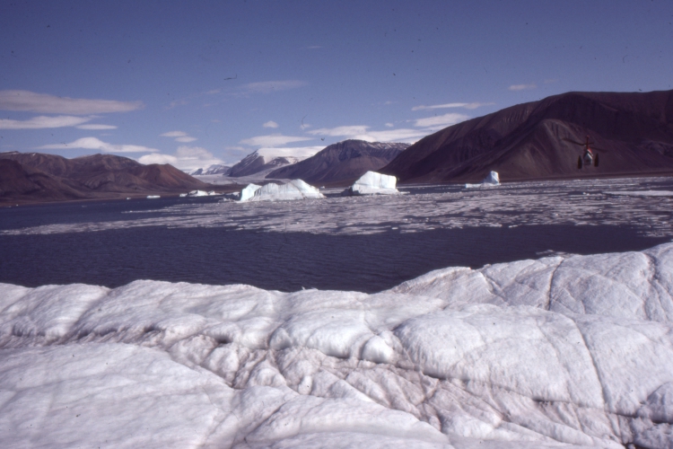
Field work in remote places is always a challenge, mentally and physically. The Canadian Arctic is no exception. Mentally, because it really is isolated, and the one or two companions you will spend the next 6-10 weeks with should be reasonably accepting of each other’s foibles. Frigid winters (minus 40o C and F – this specific temperature is the same on both scales) and snow-drift blizzards mean that most field work is a summer venture (some geophysical work is conducted during winter when fjords and seaways are frozen).
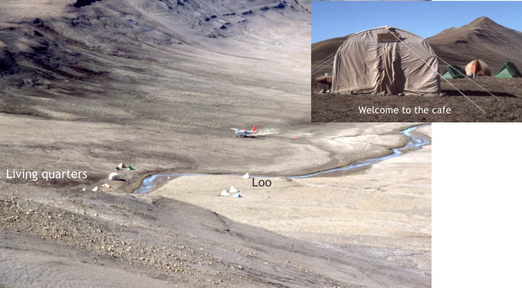
Field logistics in places like Ellesmere and Axel Heiberg islands require good planning – getting there and moving around while on site that, in addition to foot-slogging, frequently relies on a helicopter that needs fuel and an engineer. Food, tents, and general field equipment are deemed essential. A source of clean water commonly dictates the location of a camp. One base camp on western Axel Heiberg in 1983 sourced water from an iceberg a few 100 m offshore, retrieved by a helicopter dipping a 45-gallon drum into a melt pond and ferrying it to camp. That the water was probably a few thousand years old was humbling (although there was a distinct paucity of gin and tonics to take advantage of the ice). Equally important is finding a convenient spot for the loo (toilet for North American readers), placed a suitable distance from all other camp activities; one benefit of working summers in the Arctic is that you never need to stumble in the dark in search of it.
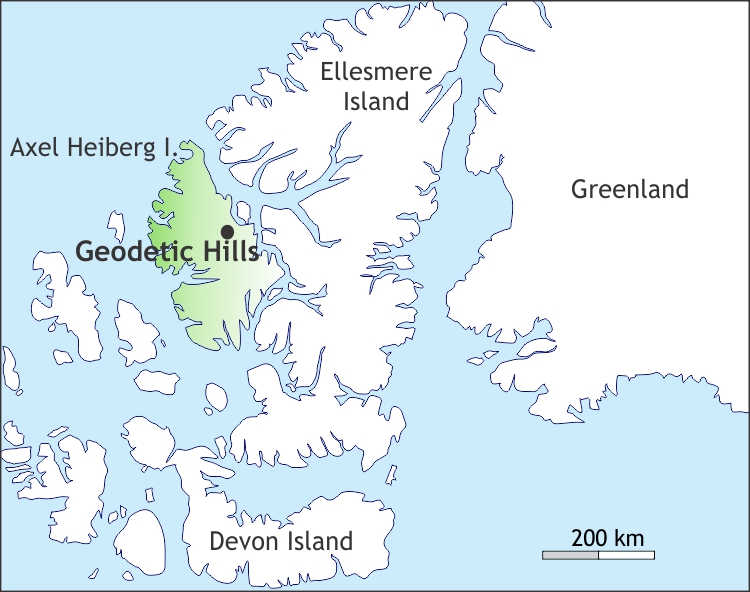
Geodetic Hills, Axel Heiberg Island
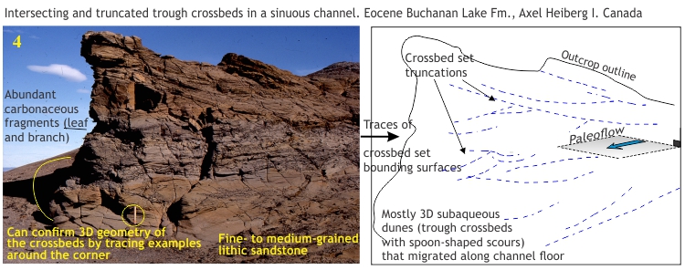
In 1985 my field assistant and I were examining sedimentary rocks on central Axel Heiberg Island. The project was part of a broader science program being run by the Geological Survey of Canada, and my role was to map and interpret the Late Cretaceous to Paleogene sedimentary basins. I had surmised, from some of my earlier work that the deposits in this sector of the island (the Buchanan Lake Formation) had formed in response to tectonic upheaval and mountain building in the region about 40 to 45 million years ago (middle Eocene); we were on the look-out for additional information to assess this hypothesis.
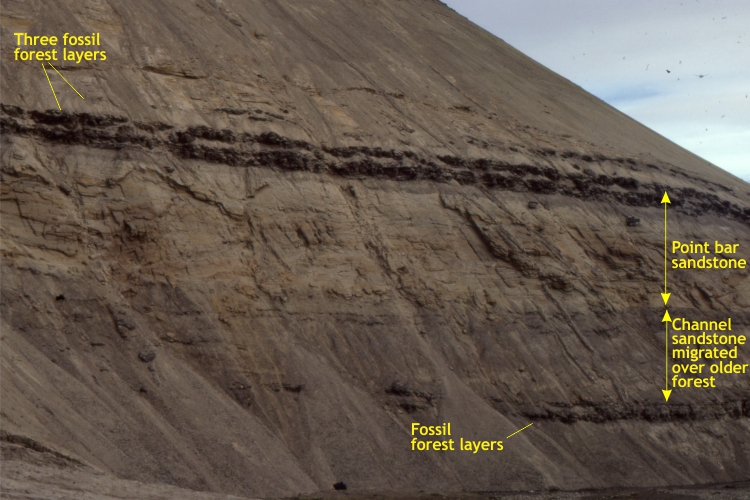
Our helicopter had dropped us off at the base of a gentle ridge, known as Geodetic Hills. It was a beautifully clear, cold summer day, as so often is the case in the eastern Arctic Islands, but very windy. Working our way up the ridge, measuring rock layers and recording observations as we progressed, we came upon thin layers of coal; at least that’s what they looked like at first glance. Beds of coal are common in Arctic geology, testaments to very different environments in ancient times, so initially these beds were of no surprise. Continuing up the ridge, we chanced upon flat ground that, as luck would have it, allowed us to walk across the top of a coaly layer. It was stunning.
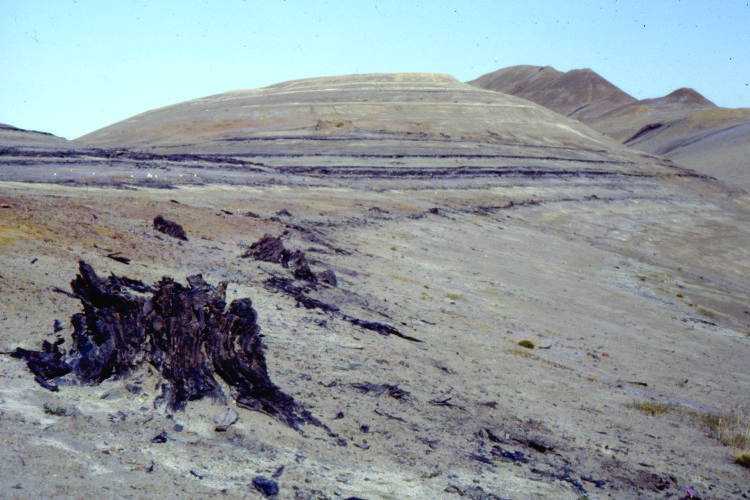
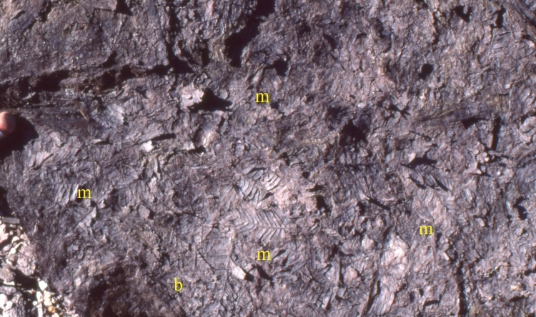
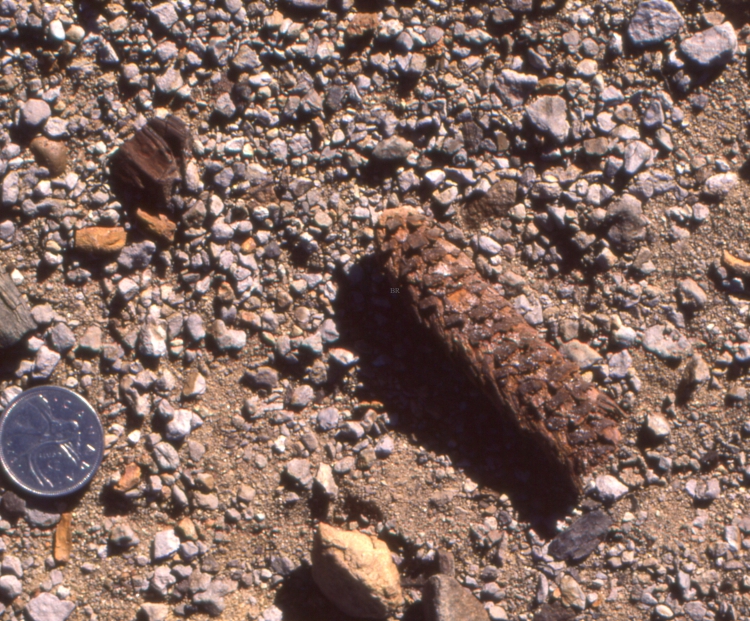
Poking out of the layer were numerous tree trunks; we were basically walking through the remains of a very old forest, around the trees, stumbling on exposed roots, branches strewn across the ground. But the real surprise was that these trees were not coal; they were darkened by age, but there was still wood – mummified wood. And this wood was 45 million years old! Mummified wood is fossil wood that has not been permineralized, and is relatively unaltered due to rapid burial.
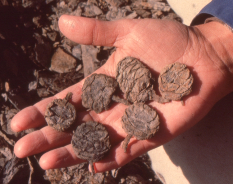
On closer inspection the layers, in addition to tree stumps and logs galore, contained fossil leaves, cones and seeds that could easily be pulled intact from the deposit. It was like extracting plant remains from a recent forest litter. Some ancient spruce or fir cones looked almost as fresh as the day, 45 million years ago, when they fell to the forest floor (today, the nearest spruce tree is about 1600km south). The litter layers were a treasure-trove – here was good evidence for a climate back in the middle Eocene that was much warmer than the modern frigid, desert conditions we were experiencing on that exposed Arctic hillside.
The puzzle continued…
There is another twist to the story. We know from Plate Tectonics theory that over long periods of geological time, continental and oceanic plates move in relation to each other, in some case many thousands of kilometres. Within this knowledge framework we also know that the land area now occupied by the Arctic Islands has basically been in the same position relative to the geographic North Pole for at least the last 100 million years. In other words, the ancient forests were at a similar (high) latitude back in the Eocene as its fossil remains are now. This being the case, the forests and whatever critters that lived therein must have experienced months of continuous summer daylight, and for the opposite season months of darkness. What kind of forests were they; and who lived there?
Back in the Eocene…
What was the rest of the world like 40-45 million years ago?
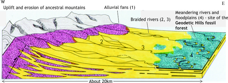
Continental and oceanic plates (other than the Arctic landmass) were in quite different positions to where they are now. A consequence of this was that the distribution of land masses, mountain belts and ocean currents, all of which contribute or help drive climate change over millions of years, were also different. Significantly, the Geodetic Hills forests flourished at a time of mountain building on Ellesmere and Axel Heiberg islands.
There were no Antarctic or Greenland icecaps, and no Arctic sea ice. The North Atlantic Ocean was quite a bit narrower than it is today. Australia was separating from Antarctica about this time, opening a major seaway that changed southern hemisphere ocean currents; New Zealand had already separated from the Antarctic-Australia amalgam long before this time. All were remnants of the Gondwana supercontinent. And importantly, from the point of view of our Arctic forests, the global climate had veered into carbon dioxide-driven hothouse conditions.
Average global temperatures began increasing in the late Paleocene. This was established initially from foraminifera oxygen isotope data (the proportion of 18O/16O is strongly correlated with temperature), and supported by multiple studies of fossil plants, pollen, and vertebrates, plus marine invertebrates.
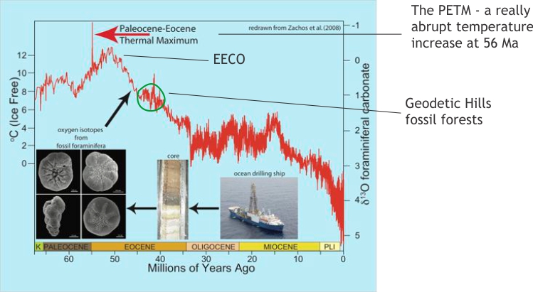
The data record a thermal maximum at about 56 Ma (the Paleocene-Eocene Thermal Maximum, or PETM), an abrupt, short-lived event that developed over a few thousand years (from a geological perspective this is very quick). The cause for this spike in average global temperatures is thought to have been a sudden introduction of CO2 into the atmosphere. The source for this sudden infusion of CO2 is unknown: it may have been volcanic. Interest in the PETM has grown recently because it offers a possible analogy for possible abrupt climatic effects resulting from modern increases in CO2. The PETM is superimposed on a more gradual increase in temperatures into the Early Eocene – this was the Early Eocene Climatic Optimum (EECO).
The Geodetic Hills fossil forests are a few million years younger than the EECO, and by this time average temperatures had cooled slightly. Note that initiation of the Antarctic Ice sheet was still 10-15 million years in the future (Early Oligocene). This then is the general climate backdrop to the Geodetic Hills’ Eocene forests – warm, and probably humid.
Fast-forward to 1986
The 1986 field season was the beginning of a concerted effort for different scientific groups to study the Geodetic Hills forests and other fossil sites in the region; this effort continues today. Earth scientists who study fossil pollen, vertebrate animal life, wood preservation, ancient soils, coals, and sedimentary rocks have at one time or another converged on this site.
The first paleobotanical analyses by Jim Bassinger (University of Saskatchewan), Jane Francis (British Antarctic Survey) and their colleagues focused on the flora and forest dynamics (tree size, tree rings, spacing, canopy). More recent field excursions that extended to similar-aged deposits beyond Geodetic Hills, have concentrated on plant physiology, leaf sizes and shapes, floral densities, floral associations and wood chemistry to interpret paleoclimatic conditions like precipitation and seasonality.
The list of plants includes ancient conifers, like hemlock, spruce, pine, larch and Dawn Redwood (Metasequoia, once thought to be extinct but subsequently found in China), the broadleaf-conifer relative Ginkgo, plus deciduous broad-leaf trees like birch, alder, oak and sycamore, and ferns. Based on trunk size and spacing, it has been inferred that some of these trees grew to 30m (100 ft) (Francis, 1991).
The only animal fossils to have been found at Geodetic Hills are the teeth of an ungulate (hooved mammal) that resembled a hippopotamus. However, slightly older Eocene deposits on nearby Ellesmere Island have revealed a diverse group of mammals such as small hedgehog-like animals, various rodents, tapirs, semi-aquatic creatures like turtles, badger-, fox-, and weasel-like carnivores, plus boa-like snakes, and a species of alligator. Presumably there were insects, but the fossil record of them at this site is poor.
So, what was the Geodetic Hills site like back in the Middle Eocene?
Picture a lowland area, carpeted with mixed conifer and deciduous broadleaf trees and shrubs, interspersed with swamps and bogs. Sluggish rivers meandered through, en-route to a more distant sea. Farther inland new mountains were shedding gravel, sand and mud, some of which was moved by the rivers and deposited on their floodplains.
There are two main schools of thought on what climate prevailed here. Early studies that examined wood chemistry, posited the hypothesis that the climate was wet and monsoonal, much like modern coastal Asia. However, a recent publication on slightly older Eocene deposits from the same area (West et al. 2015) argues the case for a seasonal rain forest based on analysis of leaf physiognomy (size and shape), including leaf area and leaf margin analyses, and comparing these with modern British Columbia coastal conditions.
Three methods commonly used to estimating paleoclimate, using proxies for paleotemperature and paleo-precipitation, from floral assemblages (information from West et al, 2015) are:
- Leaf margin analysis is an empirical, quantitative measure of mean annual paleotemperature, calculated from the ratio of toothed leaf margins to complete (smooth) margins. It is based on the observed correlation between temperature and the proportion of toothed, or serrated leaf margins to complete or smooth margins; the higher the mean annual temperature, the greater the proportion of smooth margins. However, this method only applies to woody, dicotyledonous species (one of the main groups of flowering plants).
- Likewise, mean annual precipitation can be estimated by comparing the leaf areas of fossil assemblages. Again, this is an empirical method based on modern floral associations where it can be demonstrated that leaves tend to be smaller in drier climates, because it reduces the loss of water via evapotranspiration. One advantage of the leaf margin and leaf area analyses is that taxonomic identification of leaves is not necessary (although it is desirable for forest reconstructions).
- Comparing your fossil assemblage to nearest living relatives is also useful, but is less precise than the leaf margin and leaf area analyses. This method does exactly what the title states – fossil species are compared with extant species. This method requires correct taxonomic identification of fossil leaves.
These wet and warm conditions prevailed during the middle Eocene PETM; mean annual temperatures are estimated to have been 13o-15oC (55-60°F). The Geodetic Hills forests are a bit younger and the climate had cooled slightly. But the forests flourished, enough to support various mammals and rodents, and in the swamps, alligators and turtles.
Afterword
Our walk through these ancient forests, although having scientific purpose, unlocks one’s imagination – stepping over those fallen logs 45 million years ago, brushing aside spruce and hickory boughs, swatting the odd insect, camera-ready. And depending on the season, a walk at twilight, and even total darkness. Savour the moment, because that cold blast of Arctic air will bring you back to a wind-swept ridge.
The fossil forest is still being studied. It has become an important component of a paleoclimate puzzle that many scientists believe has a direct bearing on the kind of climate changes we are witnessing today. Therein lies the value of scientific enquiry and discovery; the unexpected lies just over that ridge.
All the images used in this chapter are from geological-digressions.com
References and Further reading
R.L. Christie and N.J. McMillan, (Editors), 1991. Tertiary fossil forests of the Geodetic Hills Axel Heiberg Island, Arctic Archipelago. Geological Survey of Canada, Bulletin 403. 15 papers on many aspects of the forests.
J.J. Eberle and D.R. Greenwood. 2012. Life at the top of the greenhouse Eocene World – A review of the Eocene flora and vertebrate fauna from Canada’s high Arctic. Geological Society of America Bulletin, v. 124, p. 3-23.
J.E. Francis, 1991. The dynamics of polar fossil forests: Tertiary fossil forests of Axel Heiberg Island, Canadian Arctic Archipelago. In R.L. Christie and N.J. McMillan, (Editors), 1991. Tertiary fossil forests of the Geodetic Hills Axel Heiberg Island, Arctic Archipelago. Geological Survey of Canada, Bulletin 403, p.29-38.
G.E. Mustoe, 2018. Non-mineralized fossil wood. Geosciences, 2018, 8. This is Open Access
K. West, D.R. Greenwood and J.F. Basinger, 2015. Was the Arctic Eocene ‘rainforest’ monsoonal? Estimates of seasonal precipitation from early Eocene megafloras from Ellesmere Island, Nunavut. Earth and Planetary Science Letters v. 427 p. 18–30. Available for download. Has a useful summary of the PETM.