4 Volcanoes and Volcanic Rocks
KEY CONCEPTS
- Volcanic eruptions vary greatly in size.
- The eruption Sumatra’s Toba Volcano, 74,000 years ago, was the largest eruption known to have occurred on Earth in last 25 million years. Toba is especially significant because it may have killed most people on Earth, creating a genetic bottleneck.
- Volcanologists classify volcanos as active, dormant, or extinct.
- Volcanic eruptions may be effusive (involving lava flows) or explosive.
- Volcanoes pose many different potential hazards, including death or destruction by lava flows, volcanic gases, or volcanic ash. Secondary hazards from volcanoes include landslides and tsunamis, and effects on weather and climate.
- Scientists monitoring active volcanoes use several different approaches, but predicting eruptions is challenging.
- 50-60 volcanoes are erupting at any time – most in the Ring of Fire around the Pacific Ocean.
- The U.S. contains about 170 potentially active volcanoes, most in Alaska’s Aleutian Islands. The most recent U.S. major eruptions have, however, been in Hawaii.
- Identifying minerals and naming igneous rocks is challenging in the field and is most often done by examining thin sections or by obtaining chemical analyses of rocks.
- The International Union of Geological Sciences (IUGS) has promulgated the most widely used rock-naming and classification system for volcanic rocks. For more precision, IUGS names are modified by adding textural descriptors.
4.1 Two Significant Eruptions
4.1.1 Tambora Volcano
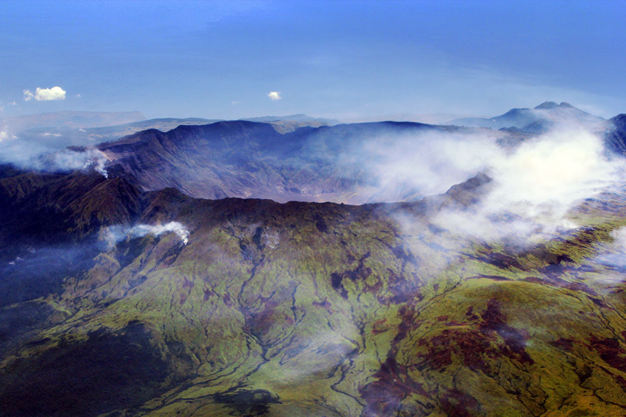
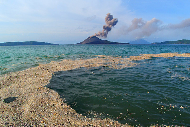
The largest volcanic eruption in recent history occurred in 1815 when Mt. Tambora, on the island of Sumbawa, Indonesia, exploded and ejected 160 cubic kilometers of material into the air. The eruption created the large depression seen in Figure 4.1. We call depressions that form this way caldera. The Tambora caldera is 6 kilometers in diameter and 1,100 meters deep. It formed when Tambora’s estimated 4,000-meter-high peak blew away and the ground collapsed as the magma chamber below emptied. Tambora is still an active volcano, and several minor eruptions have extruded lava on the caldera’s floor since the big eruption in 1815.
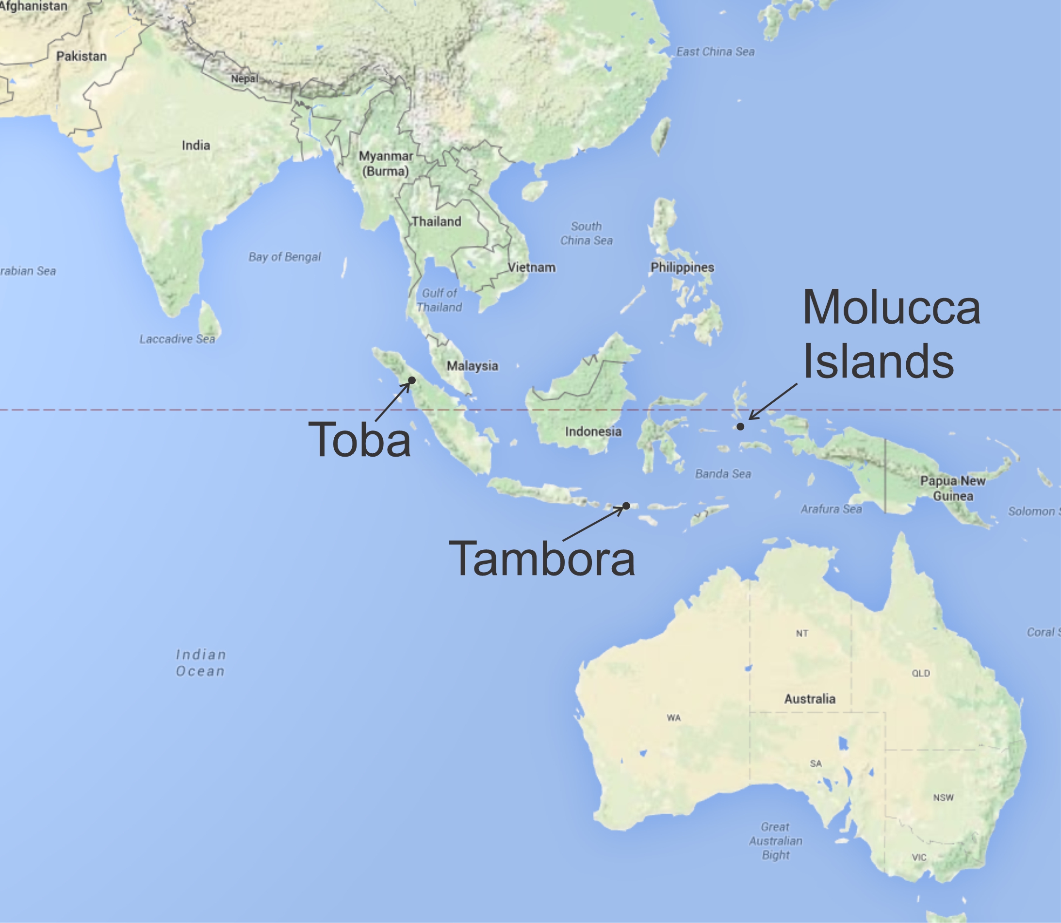
The sound of Tambora’s 1815 eruption was heard more than 1,400 kilometers away in the Molucca Islands (Figure 4.2). Thick layers of volcanic ash were deposited over a huge region, traveling thousands of kilometers from the eruption site. The ash eventually hardened to become tuff, a type of volcanic rock formed by consolidation of volcanic airfall deposits.
Volcanologists estimate that Tambora’s eruption killed at least 70,000 people, some because of the immediate effects of the explosion and ashflows, but most because of subsequent starvation and disease. Although the death toll on Sumbawa and nearby Lombok Island was huge, Tambora’s effects were felt worldwide. In the months following the eruption, volcanic ash and sulfuric acid, carried around the globe by atmospheric circulation, blocked incoming sunlight and caused the year without summer. Average global temperatures fell by 0.5 – 1 oC (1 – 2 oF), leading to crop failure and major food shortage in the northern hemisphere. Famine led to food riots in northern Europe and caused a typhus epidemic in Ireland. The effects were not as great in North America, but still, frost killed most crops in New England and parts of Pennsylvania and the region experienced snowfall in June and July.
4.1.2 Toba Volcano
We have recorded history documenting Tambora’s effects, but it was a relatively small event compared to many earlier prehistoric eruptions. Scientists interpret the history of those eruptions, and their effects on humans, using incomplete geological, anthropological, and other evidence. Toba Volcano, which erupted multiple times about 74,000 years ago, is an example. It is in northern Sumatra, Indonesia, about 2,500 kilometers (1,550 miles) northwest of Tambora Volcano (see Figure 4.2).

Figure 4.3 shows Lake Toba, the largest volcanic lake in the world. It is 100 kilometers long, 30 kilometers wide, and more than 505 meters deep. This lake occupies a large caldera, in many ways similar to the one at Tambora, where the ground collapsed when lava spewed from a magma chamber below. Toba is a supervolcano. Its caldera is thousands of times larger than typical volcanoes and 100 times larger than Tambora.
Toba erupted several times, but the last of the eruptions 74,000 years ago – the one that created the present-day caldera – was the largest, and it was the largest eruption known to have occurred on Earth in last 25 million years. Subsequent activity, many years after the large eruption, created some small cinder cones and volcanic islands in the center of Lake Toba, and several younger volcanoes along the lake rim.

Geologists have identified a few other supervolcano eruptions that were larger than Toba. The largest known eruption, the Wah Wah Springs eruption, occurred in Utah 30 million years ago. Another huge eruption created the Fish Canyon Tuff in Colorado 28 million years ago. Figure 4.4 shows some climbers on a Fish Canyon Tuff outcrop. This tuff contains several different layers of slightly different compositions, all composed of thick layers of consolidated volcanic debris. The eruption that created the tuff occurred at La Garita Caldera in southwest Colorado. In all, it produced an estimated 5,000 cubic kilometers of volcanic ash and some coarser material. The tuff layers vary in color due to slightly different compositions and are easily eroded, leading to the colorful rounded outcrops seen in this photograph.
Although there were larger eruptions, Toba is especially significant because it may have affected humans and human diversity. The eruption produced more than 2,800 cubic kilometers of ash that circled the globe, depositing ash layers 15 centimeters deep over most of South Asia. The volcano spread noxious sulfur-rich gases in all directions. Ash and sulfuric acid in the air led to cooling, generally estimated to have been 3 – 5 oC in all parts of Earth. (Some researchers, however, think the cooling may have been much greater.) Whatever the exact amount of cooling, the effects were a global ice age that lasted years and an overall Earth cooling that lasted, perhaps, 1,000 years.
Although human ancestors have been around for more than 10 million years, scientists studying mutation rates have concluded that humans could not have been evolving independently that long – we are all too genetically similar to each other. Even before geologists dated the Toba eruption, geneticists had concluded that humans descended from a small number of ancestors slightly more than 70,000 years ago. There is some debate, but most archaeologists and geneticists believe that Toba’s eruption caused a genetic bottleneck.
Humans, 74,000 years ago, mostly lived west of Indonesia, in a downwind direction from Toba. So, the direct effects of ash and gases, the longer term climate change, and loss of food, must have been significant. Many scientists believe that the once larger human population was reduced to a few survivors. Perhaps as few as 100 or 1,000 humans existed after Toba, greatly limiting genetic diversity. Although we do not know exactly where all humans lived before the Toba eruption, ample evidence suggests that there was major migration – after the effects of the eruption waned – from Africa north to Europe from between 70,000 and 60,000 years ago. Some studies also suggest that populations of humans in southern India and on some islands upwind of Toba survived the eruption too.
4.2 Volcanology
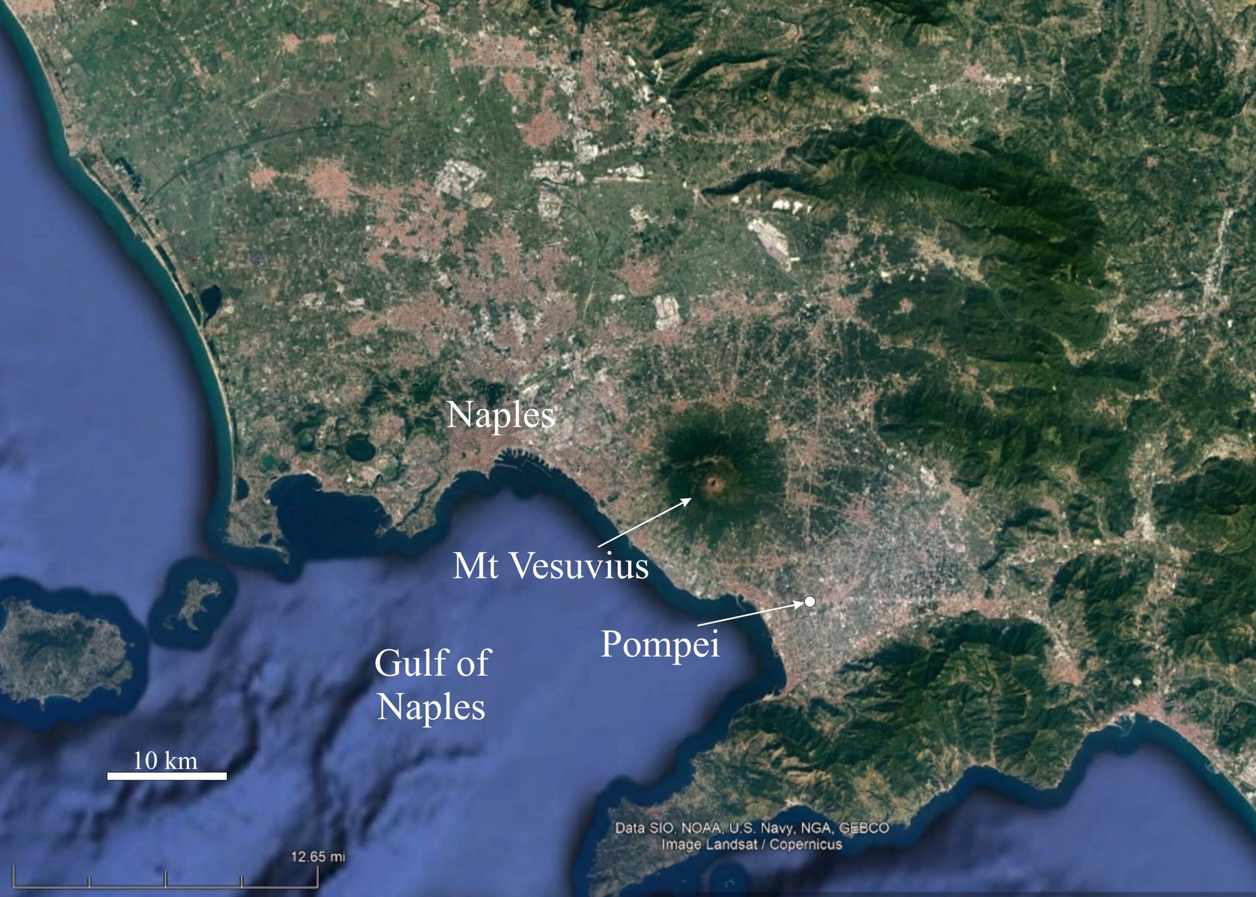
Pliny the Elder (AD 23/24 – 79) was a Roman author and naturalist. He wrote the encyclopedic Naturalis Historia (Natural History), the first encyclopedia written. Pliny was fascinated by nature of all sorts, and when Mt. Vesuvius, in southern Italy, erupted in 79 AD, he took copious notes. The eruption had already destroyed the towns of Pompeii and Herculaneum when Pliny, an officer in the Roman Navy, sailed across the Gulf of Naples to rescue people stranded a few kilometers south of Pompei in the town of Stabiae. Unfortunately, Pliny was overcome by thick clouds of hot volcanic ash and gas and died during the rescue attempt. After the senior Pliny’s death, Pliny the Younger wrote about the eruption of Vesuvius and about his uncle’s demise. His descriptions, based in part on the notes of his uncle, were so detailed and insightful that today we call eruptions similar to that of Mt. Vesuvius Plinian eruptions.
Mt. Vesuvius, best known for destroying Pompeii, has erupted many times since 79 AD – the last time in 1944 during the World War II Allied invasion of Italy. Because of its historical significance in a region of high population, Vesuvius has long been the focus of scientific investigation. Although it has not erupted in nearly 80 years, the volcano is considered one of the most dangerous in the world because of its violent eruptions and the many people who live nearby. The outskirts of Naples, with a population of more than 3 million people, is less than 10 km from Vesuvius, and other moderate sized towns sit in the volcano’s shadow.
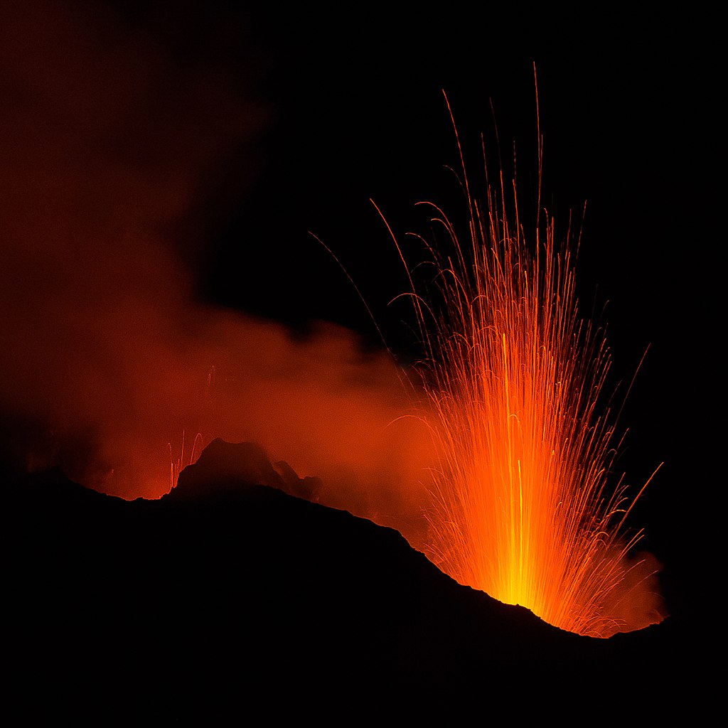
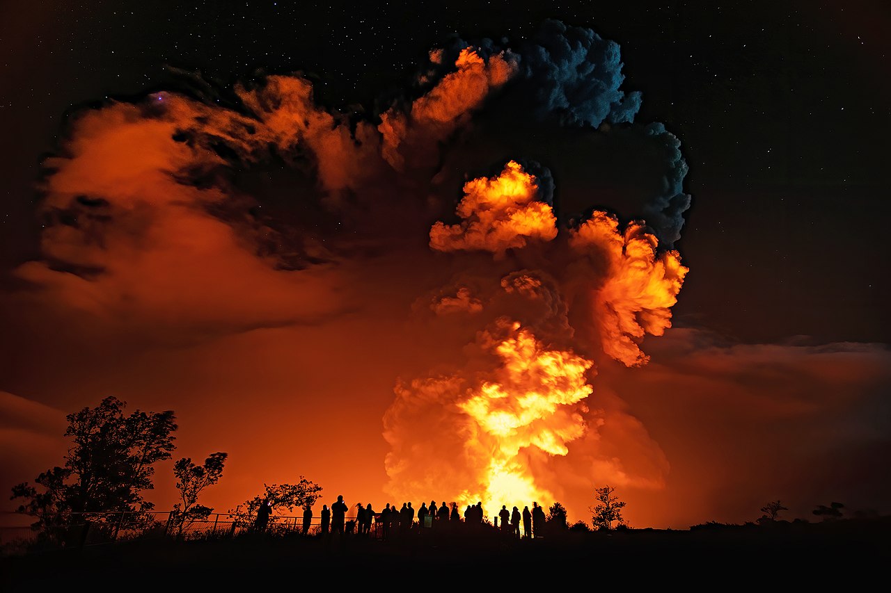
Today, Mt. Vesuvius is the only active volcano on the mainland of Europe. But, there are other active volcanoes in the Mediterranean region. Stromboli, an island volcano 225 km south of Vesuvius, has been erupting nearly continuously since 1932. Figure 4.6 is a night view of a Stromboli eruption in 2015. About 200 people live on Stromboli Island, less than 10 km from the site of active eruptions, and many tourists visit the island every year to watch the fireworks. Tourists, and the small number of residents can, in principle, be evacuated if need be, but there are periodic deaths when people linger too long after warnings are given. In 2019, a hiker died while trying to visit the summit to see an eruption close up. And, Stromboli continues to impress us today.
▶️ Click here for a link to a short 2019 video of Stromboli erupting.

Volcanology, derived from the name of the Roman god of fire, Vulcan, is the study of volcanoes. It is a hybrid science, involving investigations by geologists, geophysicists, geochemists, geodesists, archaeologists, and others. Figure 4.7 shows the first volcanological observatory, the Vesuvius Observatory near Mt. Vesuvius and Naples, that was founded in 1841. Today other dedicated volcano laboratories exist, including notably the United States Geological Survey’s Hawaiian Volcano Observatory on the Big Island of Hawaii.
Volcanologists classify volcanoes as active, dormant, or extinct. The distinctions are imprecise and sometimes used in different ways by different people. Active volcanoes are those that are erupting today or that have erupted recently. For example, Tambora is an example of an active volcano, although it has not erupted in 200 years. The Global Volcanism Program defines recently as meaning in the past 10,000 years, but some scientists are not that specific. And, in many places we don’t have a record of any sort that goes back 10,000 years.
Dormant volcanoes are presently inactive but could reasonably be expected to erupt in the future. However, it is often hard to judge reasonably if a volcano may come back to life and some dormant volcanoes may not even be recognized as volcanoes. The El Chichon volcano in Chiapas, Mexico was considered extinct until it erupted in 1982. Mt. Lamington, in Papua, New Guinea was not known to be a volcano until it erupted in 1951.
Extinct volcanoes are those that will probably never erupt again. If a volcano has not erupted for a long time – longer than the recurrence intervals of previous eruptions – it is generally considered extinct. This sort of determination requires extensive field work, mapping, and age dating. Such information is lacking for most of the world’s volcanoes. But still, even with that information, scientists are fallible, and some presumed extinct volcanoes have come back to life. For example, Chaitén volcano in Chile, thought to be extinct, erupted in 2008 but had not erupted in the previous 9,000 years.
Volcanologists study all three types of volcanoes (active, dormant, or extinct), but their tools and purposes vary. Those studying active volcanoes are concerned with predicting volcanic eruptions and protecting human lives. Active volcanoes pose many different potential hazards. Primary hazards include death or destruction by lava flows, volcanic gases, or volcanic ash. Ash, which can go as high as 40 km in the air, is particularly dangerous because it can cause jets and planes to crash. Secondary hazards from volcanoes include landslides, tsunamis (destructive tidal waves), dust inhalation, and other things. In 1985, a lahar, a name given to volcanic mudflows, traveled 48 km down a river valley from the volcano Nevada del Ruiz and engulfed the town of Armero, Columbia. It killed more than 20,000 of the town’s 29,000 residents. And, in 1986, CO2 released from volcanic Lake Nyos in Cameroon asphyxiated 2,000 people.
On a larger time scale, eruptions can affect weather and climate. For example, the eruptions of Tambora in 1815, of Krakatau in 1883, and of Pinatubo in 1991, all released huge volumes of ash and dust into the atmosphere. The ash and dust led to years-long cold spells causing crop failures and many deaths. Eruptions also add CO2, sulfate, and other gases to the atmosphere that contribute to long-term climate change. Even smaller volcanic events probably have impacts on climate but the connections are less certain.
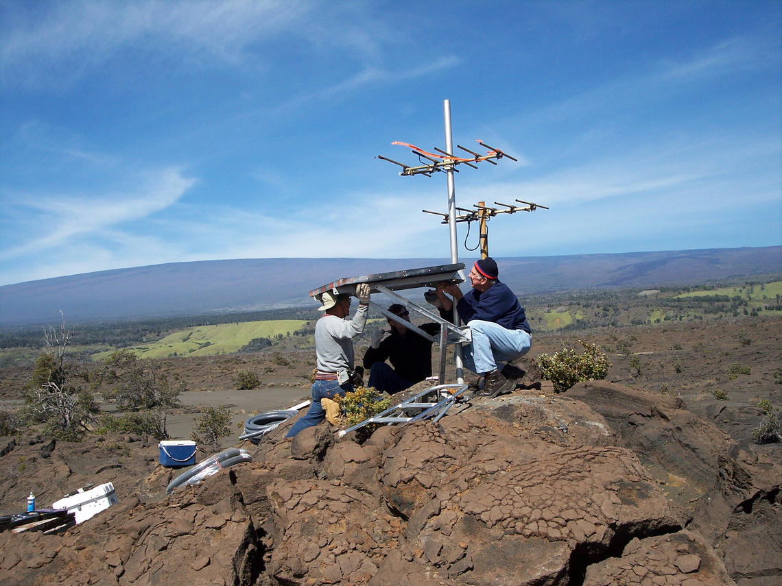
Scientists monitoring active volcanoes use several different approaches. They may install seismographs to measure Earth tremors, because tremors suggest magma movement and possible eruption (Figure 4.9). They may monitor uplift and deformation of Earth’s surface using automated land-based surveying systems and satellite measurements, because magma flowing into a region or moving toward the surface often produces bulges in the land above. They may measure gas emissions and temperatures using direct monitoring instruments or, remotely, infrared spectroscopy, because changing gas compositions, increased emissions, or temperature increases often precede an eruption. Furthermore, they may use other kinds of measurements that also yield valuable information, including measurement of gravity, magnetism and electrical resistivity.
Predicting eruptions and risks is a good thing, but often little can be done except to evacuate potential victims. People have, at times, tried to slow or divert lava flows but most attempts have been unsuccessful. In 1935, the U.S. Army Air Corps bombed lava flowing from Hawaii’s Mauna Loa to stop lava from reaching Hilo – but the lava kept flowing. Walls and earthen impoundments have had minor success several times when Mt. Etna, in Sicily, erupted. In the early 1990s, engineers diverted a flow into a trench and saved the Sicilian town of Zafferana Etnea from destruction. And in 1973, diversion barriers, and a large amount of water spraying to cool the lava, kept an eruption from destroying a town on Heimaey Island, Iceland. For the most part, however, attempts to control lavas have not worked.
Some volcanologists focus their studies on past eruptions – on dormant or extinct volcanoes – to learn how and why volcanoes erupt, to investigate Earth’s evolution, or perhaps to discover the effects that volcanoes had on civilization. Their studies include geological mapping and determining the composition and age of volcanic rocks. Those volcanologists collect rock samples in the field, make thin sections for examining rocks with microscopes, and obtain rock and mineral analyses. They study the history of volcanic activity in a region, and how it has changed over time. Additional studies may focus on the ways that volcanic activity has affected Earth’s atmosphere, climate, soil formation, and energy and ore deposits.
4.3 Volcanoes Today
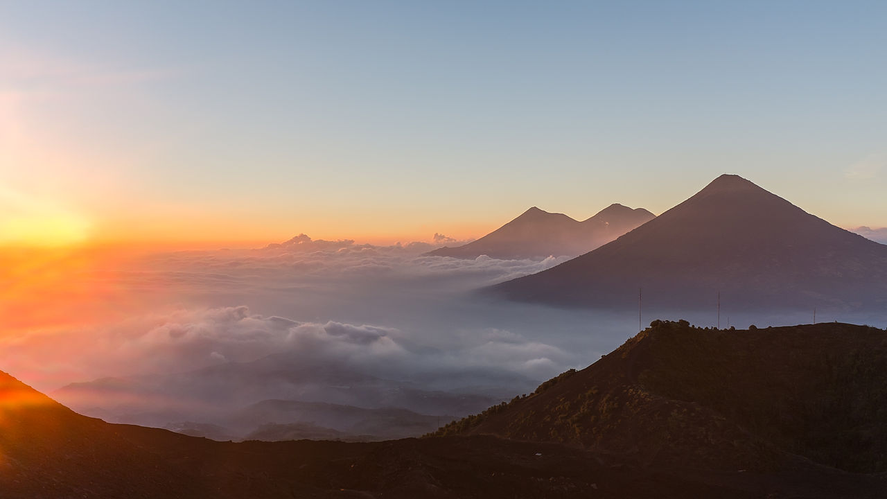
Volcanoes can be pretty spectacular and they can be pretty dangerous. But, there are many different kinds that behave in many different ways. All of them, however, are formed by eruptions of magma – very hot molten rock. When we think of volcanoes, we commonly think of steep sided conical mountains. For example, Figure 4.10 is a view of three spectacular volcanoes in Guatemala, the volcanoes Fuego, Acatenango and Agua. But most volcanic eruptions do not produce cones so beautifully formed. So, volcanic landforms vary greatly in size and shape. Eruptions may produce volcanic mountains such as those seen in this figure, but they may also yield much smaller irregularly shaped volcanic hills, and some eruptions yield sheet-like flows that cover vast areas of continents. And perhaps the most common, but rarely seen, eruptions produce the flat plains that make up the floors of the world’s oceans.
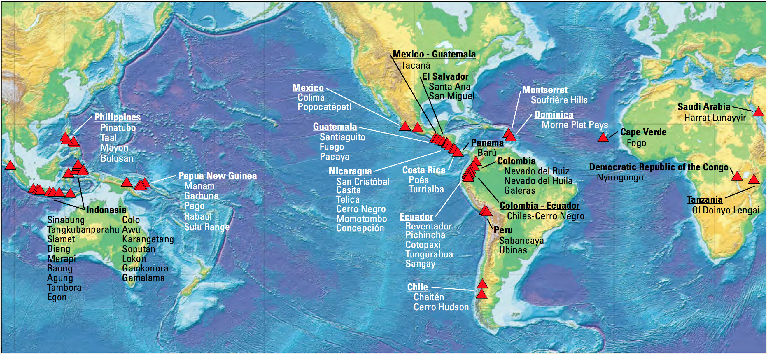
Figure 4.11 shows some of the many volcanoes that erupted between 1986 and 2018. In the United States, volcanoes in Alaska’s Aleutian Islands, on Hawaii, and Mt. St. Helens in Washington have erupted during this time span but are not labeled on this map. According to the United States Geological Survey, North America contains nearly 200 active volcanoes. This number is a bit misleading, however, because many of these volcanoes have not erupted for 1000s of years. They could, however, erupt in the future. Many other North American volcanoes are considered extinct but, as pointed out previously, extinct volcanoes occasionally come back to life.
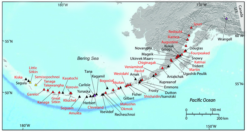
Most U.S. active volcanoes are in Alaska’s Aleutian Islands, where one or two eruptions occur every year. Notable eruptions in the last decade include Mount Cleveland, Bogoslof Island, Pavlof Volcano, and Kanaga Volcano. But, as seen in Figure 4.12, the Aleutians contain many more volcanoes than just those four.
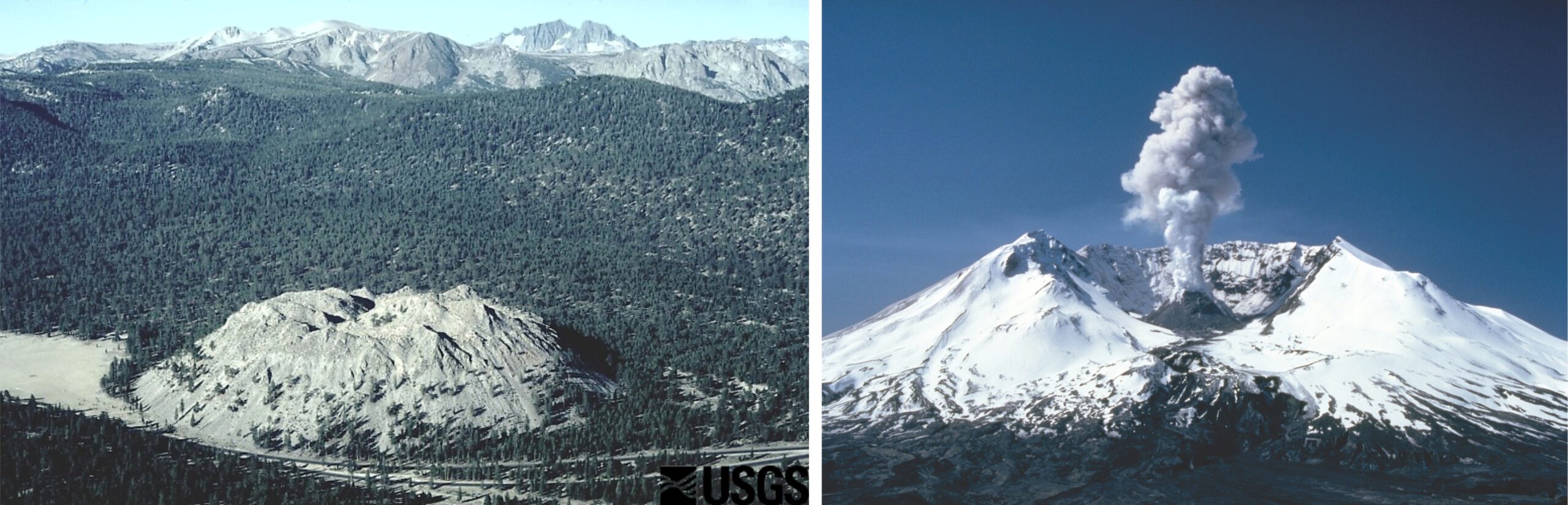
There are about 20 active volcanoes in the Pacific coast states (Washington, Oregon, California). Other active volcanoes are found in New Mexico, Arizona, Colorado, Idaho, and Wyoming. But, in the contiguous United States, only three volcanoes have erupted since our country was created: Mount St. Helens (Washington) last erupted in 2008, Lassen Peak (California) last erupted in 1917, and Mount Hood (Oregon) last erupted in 1791.
Two large active volcanoes, Mauna Loa and Mauna Kea, make up most of the island of Hawaii, the largest of the Hawaiian Islands. Unlike some volcanoes, these two have broad conical shapes. They are shield volcanoes, the largest kind of volcanic mountain. Shield volcanoes have gentle slopes because they form from basaltic lavas, which are very fluid and can spread out and flow long distances.
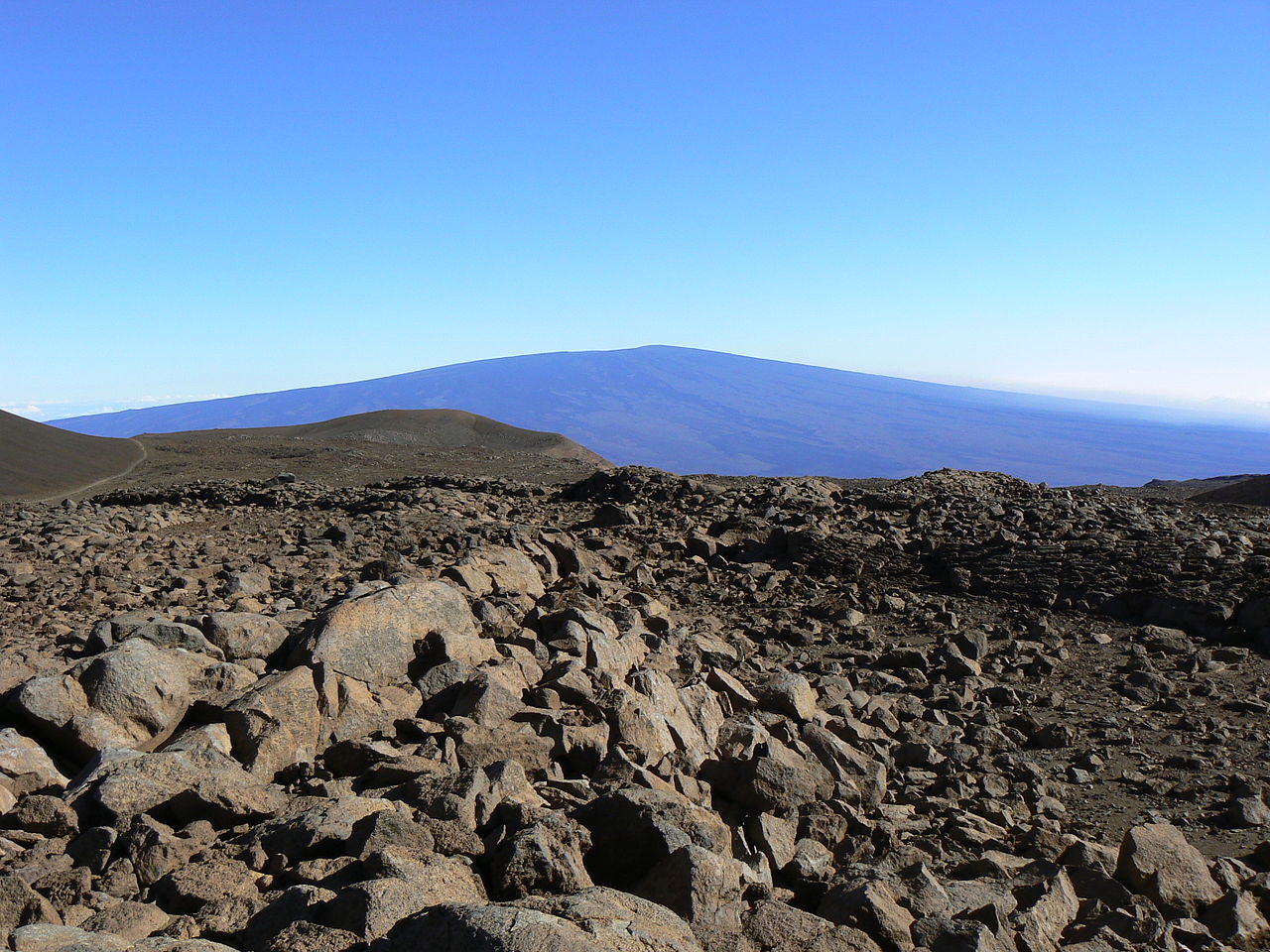
Mauna Loa, the southern of the two volcanoes, last erupted in 1984, but Mauna Kea, the northern volcano, has not erupted for 4,000 years. Figure 4.13 is a view of Mauna Loa from near the summit of Mauna Kea. The foreground contains basaltic rubble. These volcanoes appear as two topological highs on the map below in Figure 4.14a.
A third Hawaiian volcano, Kilauea, has erupted many times recently. Kilauea, which is more of a region of volcanic activity than a single volcano, occupies the southeast corner of the big island – Hawaii (Figure 4.14). The inset map on the right is an enlargement of that region. Kilauea is the most active U.S. volcano and one of the most active in the world. The volcano has a summit containing several craters just southwest of the village of Volcano, but the summit is really just a bump on the side of the much more massive Mauna Loa Volcano.
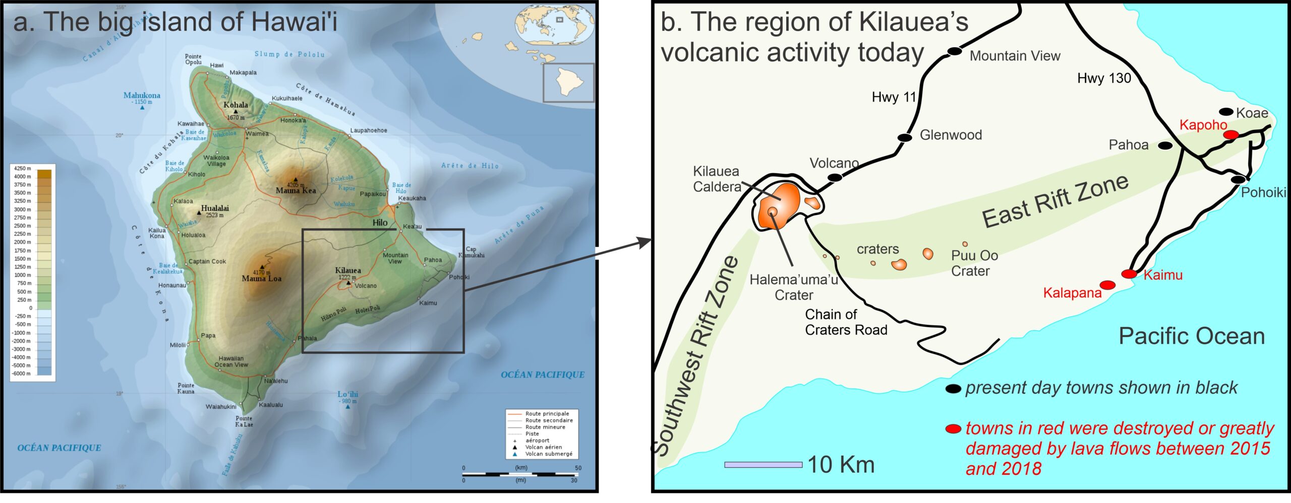
During the past 70 years, Kilauea has erupted more than 30 times, and eruptions were nearly continuous from 1983 to 2018, most in craters along Kilauea’s East Rift Zone (labeled in Figure 4.14b). Between 2015 and 2018, lava flowed from fissures in the eastern part of the rift zone. The fissure eruptions largely destroyed several towns including Kaimu, Kapoho and Kalapana. During the past several years, intermittent eruptions have also occurred in the Halema‘uma‘u crater at Kilauea’s summit.
More than 500 volcanoes have erupted since the beginning of recorded history, and volcanic activity dates back to the early days of Earth. Volcanic rocks more than 3 billion years old are found around the globe, but we cannot estimate the total number of eruptions that have occurred because much of the evidence is gone – covered or erased by later geological events. Worldwide, about 20 volcanoes are actively erupting at any given time. 50-60 volcanoes erupted at some time during the spring of 2021, when I was writing this chapter. Figure 4.15 shows currently erupting volcanoes on May 28, 2021. Most are in the Ring of Fire around the margins of the Pacific Ocean. Click on the link below the figure to see what is erupting as you read this.
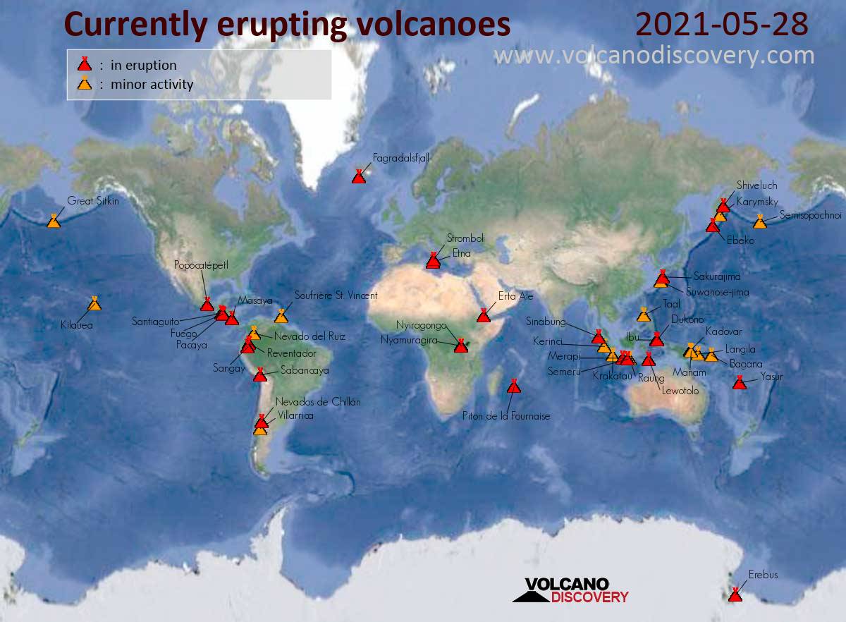
▶️ Link to map showing currently active volcanoes
4.4 Effusive and Explosive Eruptions
All volcanic eruptions involve magmas reaching Earth’s surface, but eruptions vary in violence and size. Volcanic eruptions fall into two main categories: effusive eruptions and explosive eruptions. Effusive eruptions are relatively low energy compared with violent explosive eruptions that blast magma and fragmented material into the air. For now, we will focus mostly on effusive eruptions and leave explosive eruptions for the next chapter.
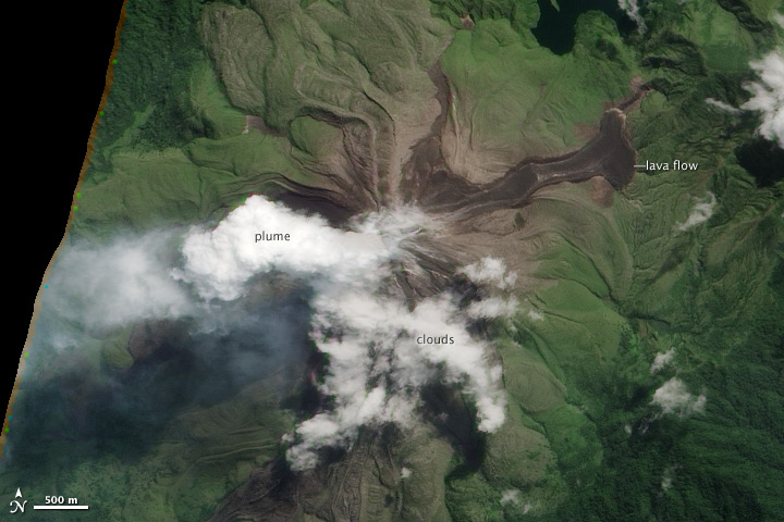
Some effusive eruptions are small and only produce spatter cones (steep-sided mounds of welded lava fragments) around small vents (any opening where magma reaches the surface). Other eruptions may produce larger lava fountains, or flows from fissures, that yield localized lava flows. Figures 4.16 to 4.19 are photos of Hawaiian eruptions. Figure 4.16 shows a spatter cone and a lava lake that formed in Kilauea’s Pu‘u ‘Ō‘ō crater in 2013. Figures 4.17 and 4.18 show 2011 East Rift Zone fissure eruptions where lava fountains are occurring. And Figure 4.19 shows a glowing river of lava surrounded by hardened basalt that is slightly older. This lava flow, which occurred in 2007, was also in Kilauea’s East Rift Zone.
|
|
|
|
|
|


Eruptions of the sorts that typify the recent activity in Hawaii are sometimes called Hawaiian eruptions, or Hawaiian-type eruptions (even if they do not occur in Hawaii.) More properly, we call any eruption that involves lava flows on the surface, an effusive eruption. Effusive eruptions may be single events, or multiple eruptions in the same area, but the volume and violence of the eruptions are generally relatively small and localized compared with other large eruptions that may have global impacts.
Although they occur in other places, most of the best photographs of effusive eruptions come from Hawaii because that is the site of much recent volcanic activity, and because photographic techniques today are much better than in the past. The maps in Figure 4.14 show the part of Hawaii where the most recent volcanism has occurred.
Magmas that produce effusive eruptions are generally basaltic. This is because mafic magmas have low viscosities and generally do not retain high gas contents or gas bubbles that could power a large explosive event. Less common intermediate and silicic lava flows are more viscous than basalt and may form blocky lava flows or steep-sided lava domes – hills of lava too viscous to spread out. Extensive rhyolitic flows are uncommon because silicic magmas tend to erupt explosively instead of flowing effusively.

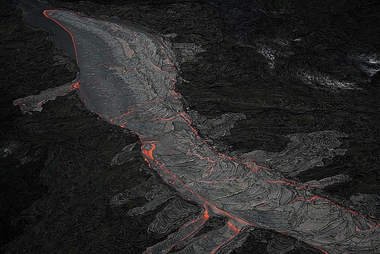
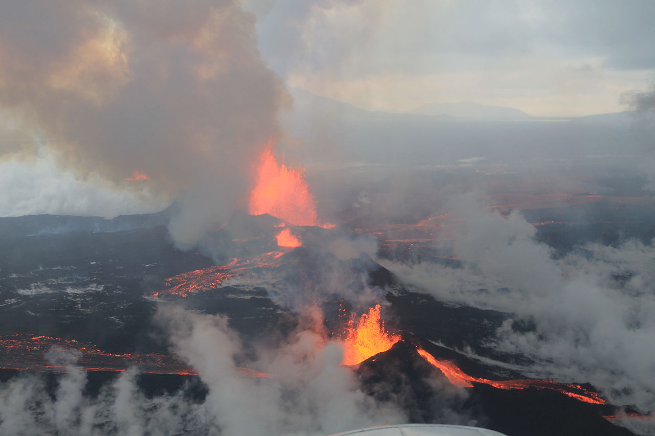
Effusive eruptions begin when magma moves upwards through fractures and eventually reaches the surface. If eruption activity is concentrated in one place, a single volcano may form. But commonly, as in Hawaii today, linear fracture zones lead to multiple fissure eruptions that occur in rift zones over considerable distance. Kilauea has two rift zones, labeled in the map of Figure 4.14. The East Rift Zone extends 50 kilometers from Kilauea’s summit to the ocean, and then another 80 kilometers beneath the sea. The Southwest Rift Zone, which is not as active, extends from the summit a shorter distance and has only a small part under the ocean. The photos in Figure 4.18, above, show recent eruptions in the East Rift Zone. Figure 4.20 is a photo of hardened basalt from an earlier eruption in the same area.

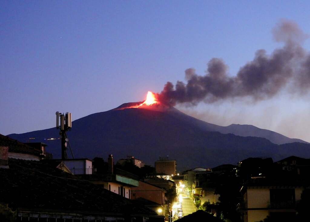
Effusive eruptions can be spectacular, especially when viewed at night. The photo in Figure 4.21 shows flows emanating from Mt Etna, Italy, in 2001. Although only moving 2-3 meters per hour, the lava eventually reached the town of Nicolisi and caused considerable damage. Taking photos like this one, with glowing lava rivers, is generally only possible after dark. During the day, steam and smoke reflect sunlight, masking any views of flowing lava.
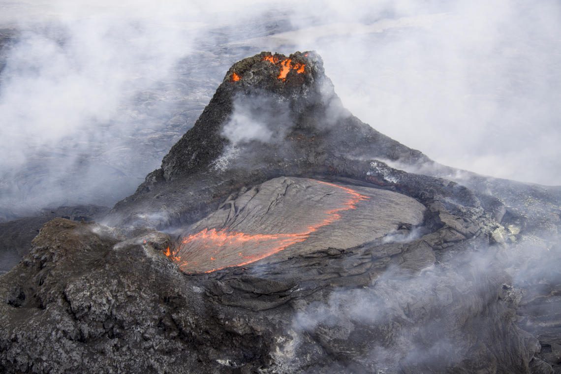
Fluid lavas generally do not explode, but they can contain dissolved gases that expand and propel lava fountains tens to hundreds of meters into the air. Figure 4.22 shows a lava fountain at the summit of Mount Etna, Italy, in 2021, and Figure 4.23 shows multiple fountains and lava flows at Bardarbunga Volcano, Iceland in 2014. When fountaining magma returns to Earth it creates lava lakes and lava flows such as those in the photos in this chapter. Once hardened into rock, lavas may contain vesicles that were once the gas bubbles that powered fountains.
|
|
|
4.4.1 Different Kinds of Lava Flows
Basaltic lava flows fall conveniently into three categories; ʻaʻā and pāhoehoe are the most common. Blocky lava flows are less common. Basaltic lava tends to spread out, and lava flows of all three kinds tend to be thin, perhaps up to a few meters thick. The different kinds of flows may be intermingled.
|
|
|
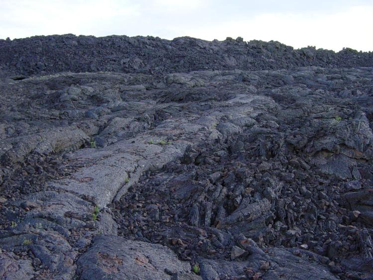

The names ʻaʻā and pāhoehoe derive from descriptions of flows on Hawaii. Pāhoehoe flows have a smooth, billowy, or ropy surface. ʻAʻā flows have a rough blocky, spiny or jagged surface akin to clinker. The rougher texture develops as partially hardened lava tumbles over itself during gradual flow advance. Figure 4.24 is a photo of lava in Craters of the Moon National Monument, Idaho, the smooth flows in this photo are pāhoehoe and the rough flows are ʻaʻā. Figure 4.25 shows a blocky lava flow in Utah.

Figure 4.26a shows a June, 1986, eruption from a lava vent on the side of Kilauea’s Pu‘u ‘Ō‘ō cone. The glowing lava rivers flowed for days and have flowed intermittently since then, creating both ʻaʻā and pāhoehoe basalts. Lava from several different East Rift Zone eruptions has traveled downhill several kilometers and covered roads near the Hawaiian coast. Figure 4.26b shows partially solidified basalt and a no longer needed “No Parking” sign that restricted parking on Chain of Craters Road in Hawaii Volcanoes National Park. Some Hawaiian flows travel greater distances than the flows shown, but never more than 5 or 10 kilometers.

Lava flowing at the surface may move relatively slowly, but if magma is confined underground in lava tubes where it can maintain high temperatures, it will be less viscous and thus flow much faster. Often swift magma rivers are capped by thin layers of solidified rock. If the rocks are too then, they may collapse, producing a skylight and providing a view of the magma below. The geologists in Figure 4.27 are looking through a skylight at magma flowing rapidly through a lava tube in Hawaii Volcanoes National Park. Magmas of this sort may travel as fast as 35 kilometers an hour.
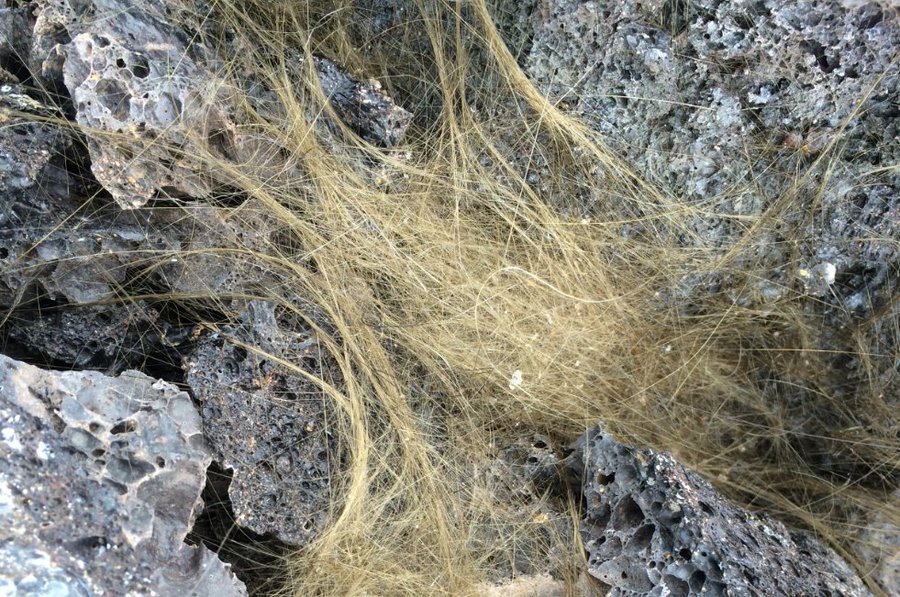
When lava cools and hardens, no matter its composition, it becomes a rock, also called lava. The geologists in Figure 4.27 are standing on recently formed basaltic lava (rock) created by a Kilauea eruption. This basalt, like most basalts, contains a great deal of volcanic glass and no mineral crystals that are visible with the naked eye. Cooling magma droplets from lava fountains often form fine glassy threads called Pele’s hair that collect on flow surfaces; Figure 4.28 shows some examples. Pele’s hair is ubiquitous on the flows in Kilauea’s East Rift Zone today.
4.4.2 Submarine Eruptions
|
|
|
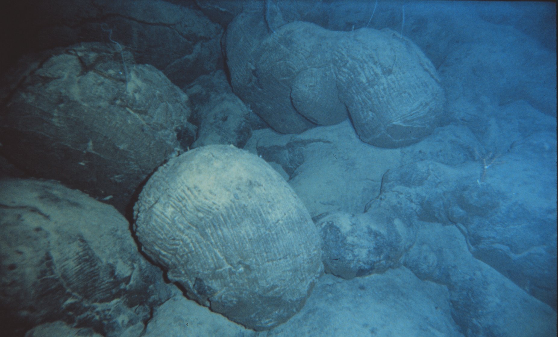
Although eruptions on land are the ones we generally think about, some effusive eruptions are submarine. This photograph (Figure 4.29) shows pillow basalts, named for their shape, on the ocean floor near Hawaii. Pillows like these form when basalt erupts under water and, consequently, cools rapidly before it can flow any long distance. In some places, pillow basalts have been incorporated into continents and uplifted above sea level. They, thus, become more amenable to study. Figure 4.30 shows an example of basalt pillows from Pt. Bonita, near San Francisco.
4.5 Naming Volcanic Rocks
We name some volcanic rocks based their mineralogy. The common primary minerals in volcanic rocks are generally quartz, K-feldspar, plagioclase, muscovite, biotite, amphibole, pyroxene, or olivine (Table 2.1 in Chapter 2). These are the essential minerals sometimes used to assign rock names. However, many volcanic rocks contain small or large amounts of volcanic glass instead of minerals, or contain mineral crystals that are too fine grained for easy identification even with aid of thin sections and a petrographic microscope.
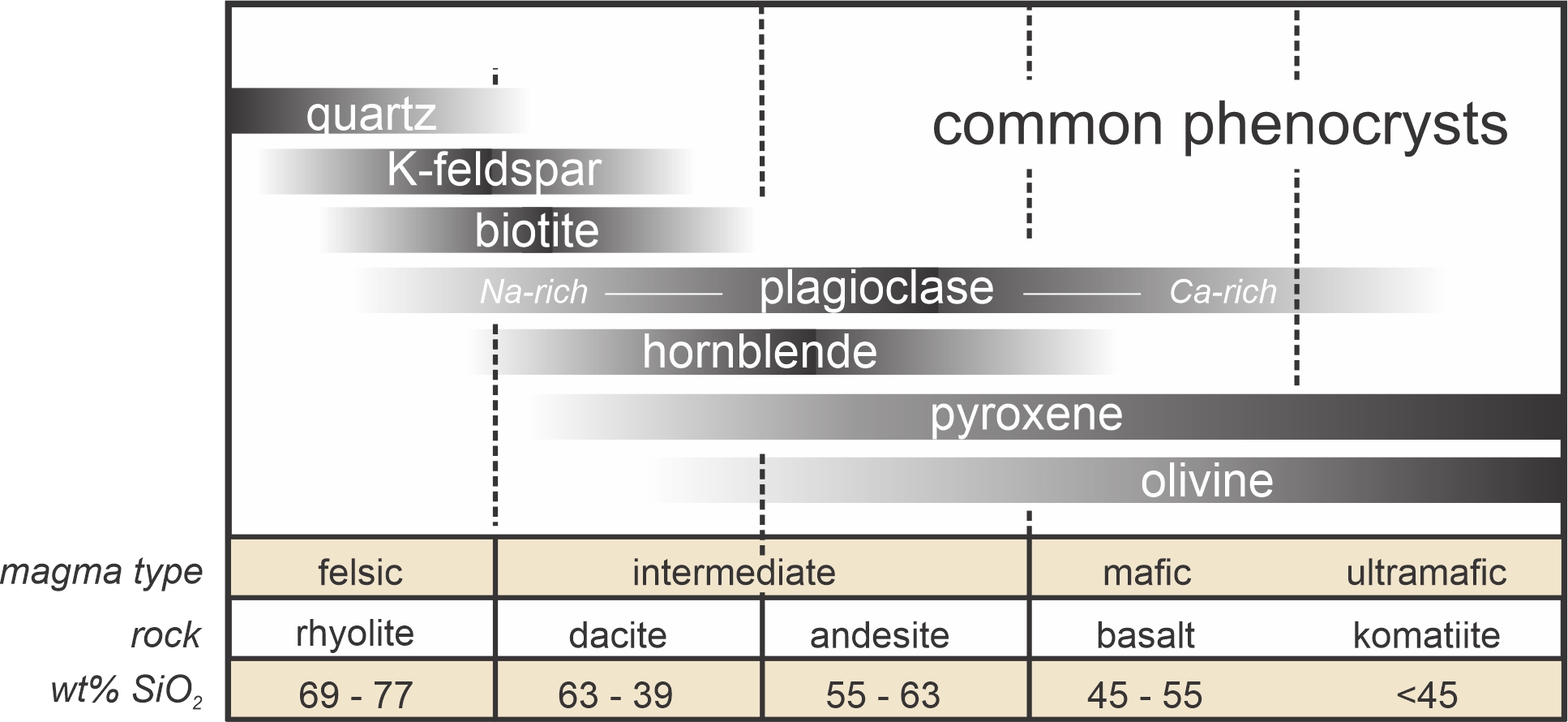
Although they may contain only fine grains, if present, larger phenocrysts help distinguish different kinds of volcanic rocks. Figure 4.31 shows the common phenocrysts in rocks ranging from those that are silica-rich to those that are relatively silica-poor. These phenocryst minerals are the same minerals that may be present as microscopic crystals in the groundmass. Quartz and K-feldspar are generally restricted to relatively silicic rocks, olivine and pyroxene to relatively mafic rocks. The other minerals are most common in intermediate rocks. Plagioclase is a solid-solution mineral in volcanic rocks and varies from being Na-rich for silicic rocks to being Ca-rich for mafic and ultramafic rocks. Figure 4.31 is only an approximation because the minerals present as phenocrysts depend also on other things besides silica content (the horizontal axis in the figure). And in some porphyries, where the amount of phenocrysts is small compared with the amount of groundmass, phenocryst mineralogy may not well represent the overall rock composition. So, sometimes classifying and naming volcanic rocks based on mineralogy is problematic.
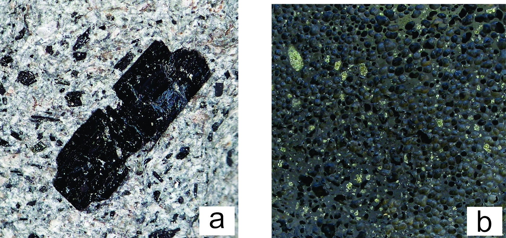
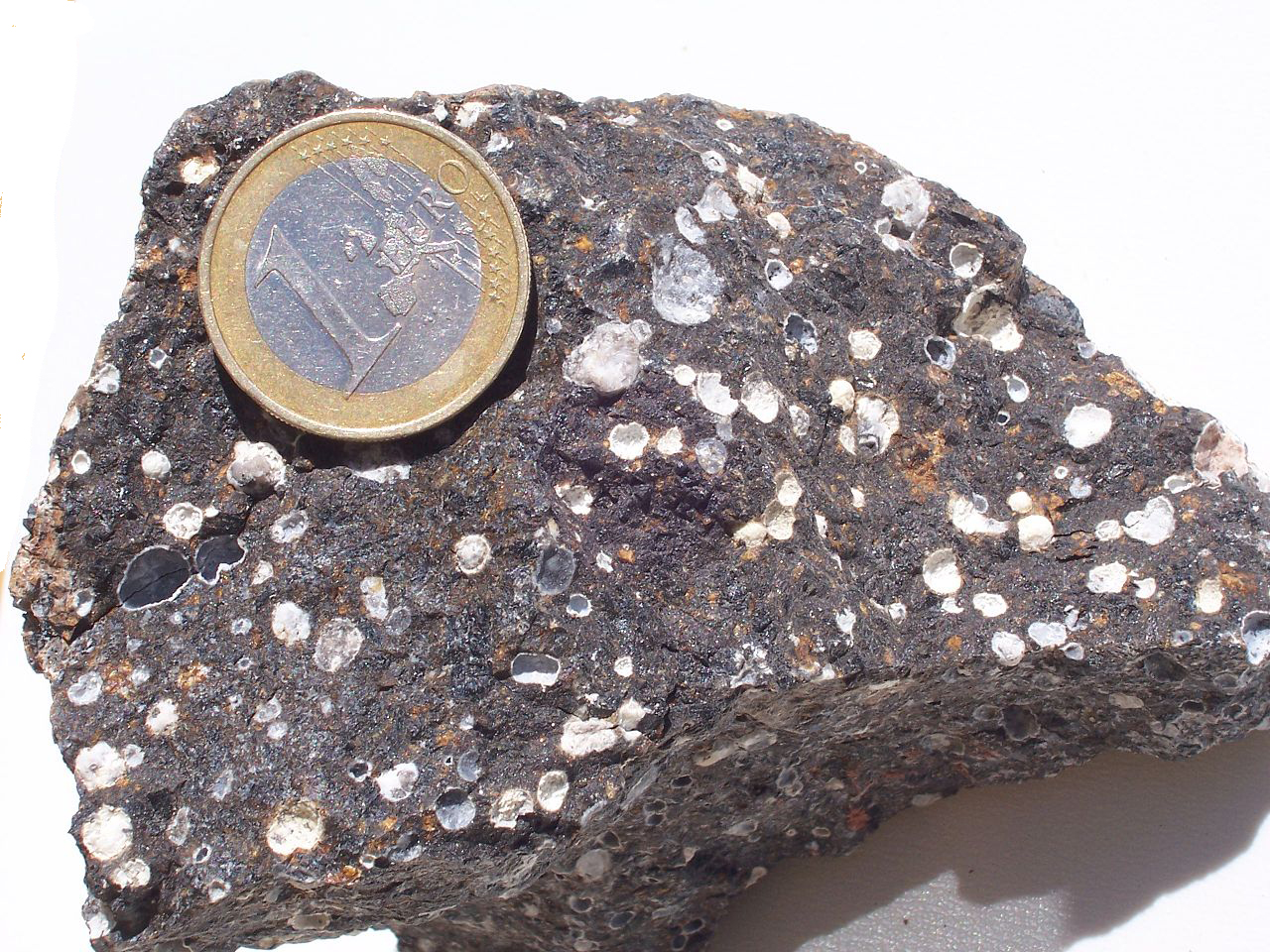
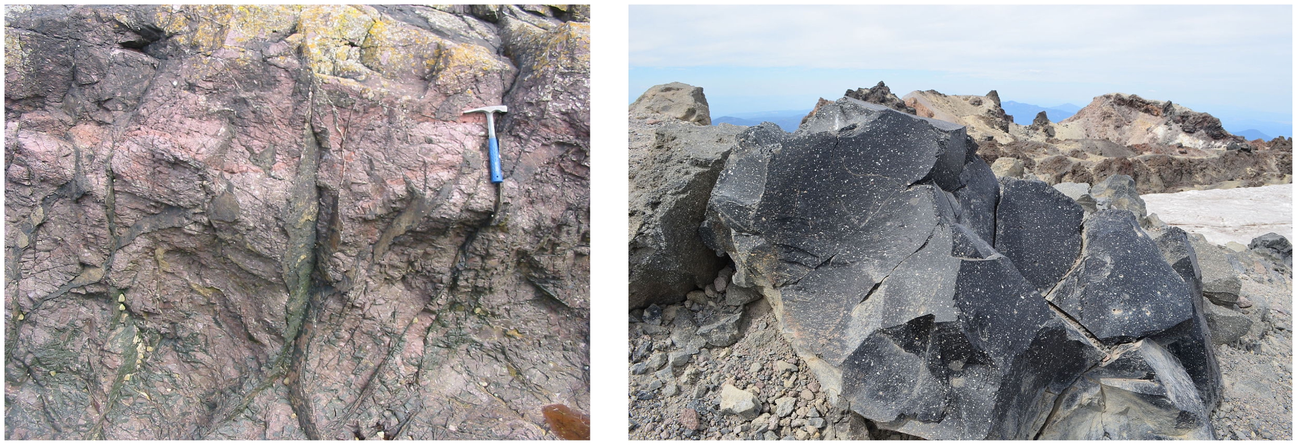
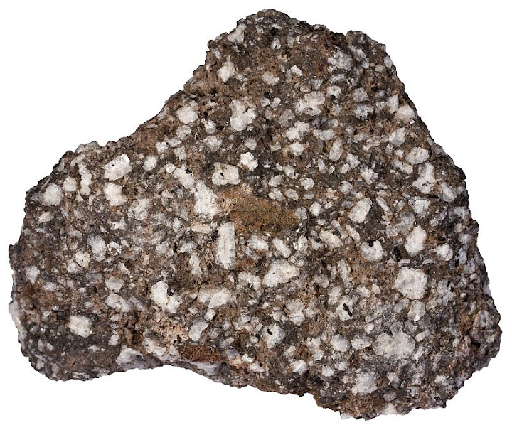
We commonly modify volcanic rock names based on rock textures. For example, this view (Figure 4.32a) of a porphyritic andesite shows an intermediate composition rock that contains small lath-like plagioclase (light-colored) and a one-centimeter long phenocryst of black accessory augite (pyroxene). Smaller augite crystals are also present but hard to pick out. Besides texture, we may modify rock names based on characterizing accessory minerals too. For example, the vesicular olivine basalt shown in Figure 4.32b (from La Palma, Canary Islands) contains many 3-5 millimeter-sized vesicles and relatively large green olivine phenocrysts in a fine-grained matrix.
| Chapter 16 (Section 16.2) contains many photos of volcanic rocks in hand specimen and in thin section. If you want to know what they look like, go there. |
4.5.1 The IUGS System for Naming Volcanic Rocks
The International Union of Geological Sciences (IUGS) developed a standard classification system that divides volcanic rocks into fundamental groups, each of which contain several rock types:
xx• feldspar-containing effusive rocks
xx• pyroclastic rocks
xx• ultramafic rocks
xx• carbonatites
xx• melilitic and related rocks
xx• high-Mg rocks
Unfortunately, identifying and naming rocks cannot be done the same way for all groups. Some names are assigned based on the minerals a rock contains, some based on the overall rock chemistry, and some by rock texture. The most important groups of volcanic rocks are feldspathic effusive rocks, pyroclastic rocks, and mafic rocks. These groups include the most common volcanic rocks at Earth’s surface. Rocks belonging to other groups are quite rare and we will not discuss naming them further in this book. And in this chapter, we will only consider the IUGS system for feldspar-containing effusive rocks. Despite some lingering debate and some shortcoming, this IUGS system gives useful and consistent results for any rock that contains at least 10% by volume of identifiable quartz, alkali feldspar, plagioclase, and feldspathoids combined. One difficulty, however, is that the IUGS system often requires obtaining a rock analysis, something that cannot be readily done in the field.
4.5.1.1 The QAPF Classification System
Some effusive rocks contain quartz, alkali feldspar, and plagioclase, singly or in combination. If we can identify these minerals and their relative proportions, the proportions yield an IUGS rock name. Typically, we examine a thin section of a rock to determine the modes (volume %) of quartz (Q), alkali feldspar (A), plagioclase (P), and feldspathoids (F) present. After normalizing the percent values to 100%, we plot the results on the IUGS QAPF diagram, shown in Figure 4.33, to get a rock name.
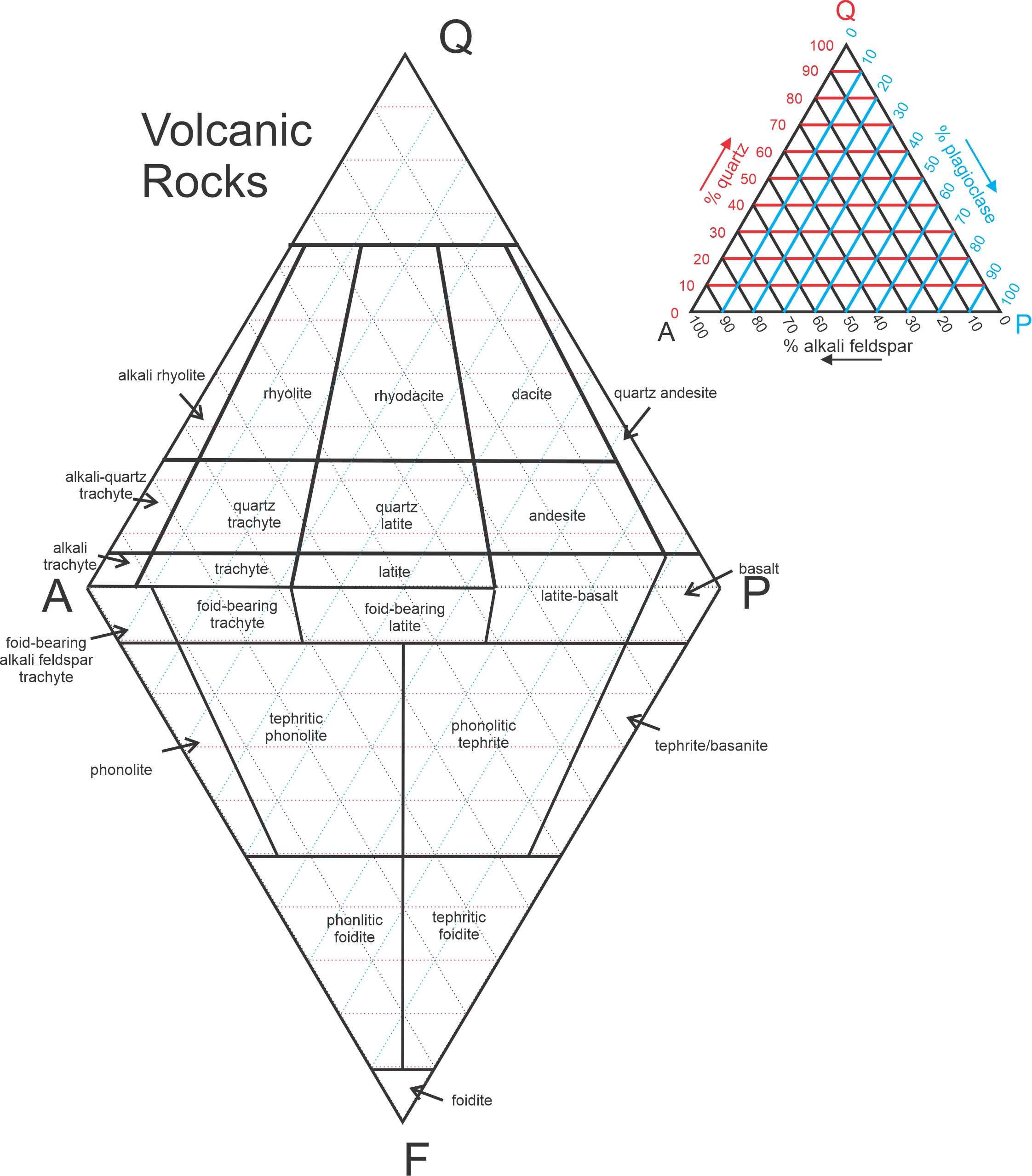
The QAPF diagram contains two different triangles (top and bottom of Figure 4.33) that share the AP line. The top QAP triangle applies to rocks that contain quartz. The less commonly used upside down bottom APF triangle applies to rocks that, due to low SiO2 content, do not contain any quartz. If rocks do not contain quartz, they often contain a mineral belonging to the feldspathoid group. So, for low-SiO2 rocks, feldspathoids (most commonly leucite or nepheline) may replace quartz, and naming is based on the modes of alkali feldspar, plagioclase, and a feldspathoid. Because quartz and feldspathoids are never found together, it is generally clear whether to use the top or bottom half of the diagram. Some of the rock names in this system include the term foidite, an abbreviation for feldspathoid-bearing rock.
Most igneous rocks contain minerals other than quartz, alkali feldspar, plagioclase, and feldspathoids. Some may contain abundant mafic minerals such as olivine or pyroxene, but the IUGS system for feldspathic effusive rocks does not consider this. Consequently, two rocks with dissimilar appearance may have the same name using this system. Other effusive rocks may be extremely mafic, containing very small amounts, or no, quartz and feldspars. For such rocks, we must use the IUGS classification system for ultramafic rocks. Furthermore, when looking at a hand specimen, we may not be able to distinguish plagioclase from alkali feldspar, making the standard IUGS system unworkable.
4.5.1.2 The TAS Alternative
Determining accurate mineral modes for volcanic rocks can be difficult or impossible due to small grain size or the presence of glass. Although some volcanic rocks contain larger phenocrysts, the modes of phenocrysts may not reflect the true mineral modes. The IUGS recommends using a TAS (total-alkali-silica) diagram (Figure 4.34) to name rocks if mineral modes cannot be determined accurately. The TAS system is, today, more often used than the QAPF system for naming volcanic rocks. This figure contains the same diagram presented in Chapter 3 (Figure 3.45) to name magmas, so an advantage is that this system gives a rock and its parent magma the same name. A second advantage is that this system is based on rock chemistry. So, even rocks that contain no visible minerals, or that contain large amounts of glass, can be unambiguously named.

In the TAS diagram, the vertical axis is the total alkali oxide (Na2O + K2O) content of a rock and the horizontal axis is the silica (SiO2) content. The diagonal red line divides rocks into alkalic (top) and sub-alkalic (bottom) categories. To use the TAS system, we must know the chemical composition of a rock, so we can plot rock composition appropriately. Acquiring whole rock chemical analyses is not difficult but is more complicated than making thin sections. It can be time consuming and requires specialized analytical instruments. The most common analysis methods used today are X-ray fluorescence spectroscopy (XRF) and inductively coupled plasma-mass spectrometry (ICP-MS). Chapter 1 contains descriptions and photographs of these instruments.
The TAS and QAPF classification systems are closely related, and the two systems yield the same, or nearly the same, rock names if we can apply them both. The horizontal axis in the TAS diagram (weight % SiO2) correlates with the vertical axis in QAPF diagram (the amount of quartz or feldspathoids present in a rock) because the modal amounts of either quartz or feldspathoids are functions of SiO2 concentrations. Rocks that contain abundant quartz are relatively rich in SiO2; those that contain less quartz contain less SiO2. Rocks that contain feldspathoids (foidites) are even poorer in SiO2. The vertical axis in the TAS diagram (weight % Na2O + K2O) correlates with the horizontal axis in the QAPF diagram because feldspathic rocks high in Na2O + K2O generally contain abundant K-feldspar; those that contain less Na2O + K2O contain more plagioclase.
4.5.2 Textures of Volcanic Rocks
All basalts have about the same chemical composition and consist primarily of two minerals: plagioclase and clinopyroxene. But different basalts may not appear the same because they have different textures or fabrics. For example, basalt may be glassy, massive, porphyritic, vesicular, or scoriaceous. So, we may modify rock names with textural terms, and say perhaps that a rock is a glassy basalt, a massive basalt, a porphyritic basalt, etc.
The most important things that determine the texture of an igneous rock are magma composition and cooling history. Magma composition is important because it dictates the minerals that can form, and different minerals have different shapes and may form at different temperatures. Consequently, mineral crystals may grow into, or around, crystals of other minerals.
Cooling history includes the cooling rate, whether cooling was continuous or occurred in stages, and crystallization temperatures. Temperature is a key because it affects the rate of nucleation, which is the rate that new crystals begin to form from just a few atoms. Temperature also controls the diffusion rate – the rate at which atoms can move (diffuse) to sites of growing crystals. At higher temperatures, nucleation and crystal growth are more rapid compared with lower temperatures.
In the sections below, we review the most common textures seen in volcanic rocks. Many of the terms were introduced before, but here we try to put them in a larger context by comparing them and relating them to each other. These terms apply to rocks of many compositons, and some of them are also used to describe textures of plutonic rocks.
4.5.2.1 Grain Size and Related Characteristics
Cooling rate is the most important factor influencing grain size. Over time, crystals tend to grow larger at the expense of smaller crystals. This process, termed Ostwald ripening, occurs because larger crystals have lower surface energies – and thus are more stable – than smaller crystals. Additionally, multiple crystals may grow into each other and coalesce to produce compound grains, or recrystallize to produce a single larger grain. So, slow cooling generally leads to large crystals and fast cooling does not.
Igneous rocks come with a wide varieties of textures related to grain size. As discussed in Chapter 2, intrusive rocks generally are phaneritic, meaning they contain grains visible with the naked eye. Especially coarse-grained intrusive rocks have a pegmatitic texture. Extrusive rocks, in contrast with intrusive rocks, are generally aphanitic. Aphanitic rocks are very fine grained. Crystals, which may be microcrystals up to a few tenths of a millimeter across, can only be seen using a microscope. Cryptocrystalline rocks contain even finer crystals – crystals not visible even with a microscope.
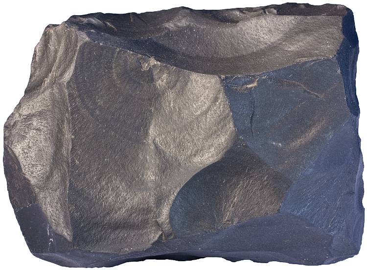
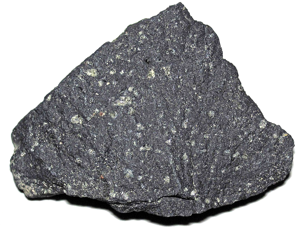
Figure 4.35 shows an aphanitic basalt that contains only microscopic grains. The rock has a massive texture, meaning it has uniform grain size, a random arrangement of grains and shows no planar or linear features. A thin-section view of this rock would reveal that it is made of augite, plagioclase, and much volcanic glass.
4.5.2.2 Crystalline and Fragmental Rocks
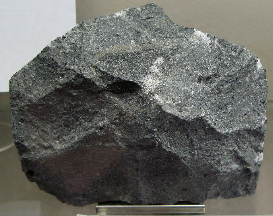
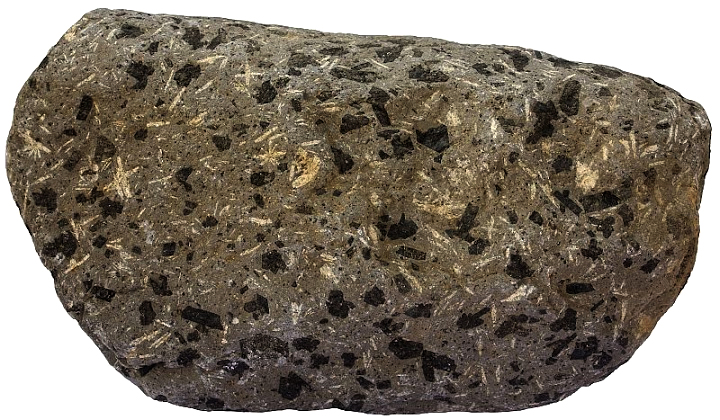
Many extrusive rocks are partly to entirely crystalline. They are made of interlocking crystals that formed when molten rock cooled. For example the latite in Figure 4.36 (composed of fine crystals of plagioclase, K-feldspar and dark-colored biotite and augite) is a crystalline rock. Other extrusive rocks are fragmental, also called pyroclastic, or volcanoclastic rocks. They consist of some combination of mineral crystals, rock fragments, pumice, or volcanic ash cemented together. The tuff in Figure 4.37 is a good example. The different rock constituents settled from a jumbled cloud of ash and coarser debris and subsequently became welded together during lithification.
4.5.2.3 Vesicles and Amygdules
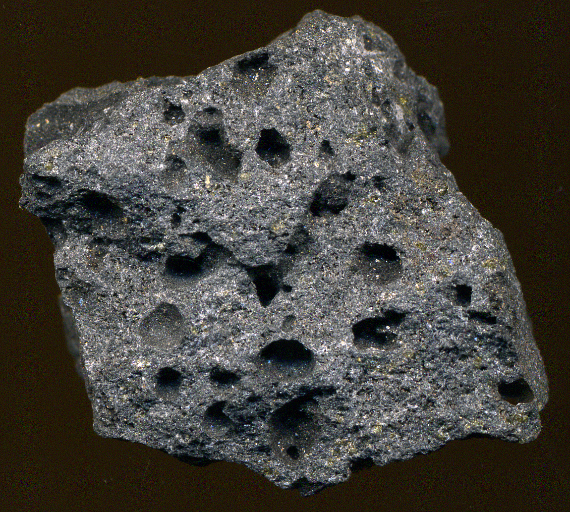

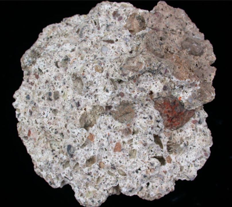
Vesicles, gas bubbles trapped in magma as it cools and hardens, are a common feature of basalts and many other kinds of volcanic rocks. Vesicles are holes or cavities, spherical or sometimes elongated, that range from millimeters to centimeters in scale. Figure 4.38 shows a vesicular rock that contains millimeter-sized crystals of pale green olivine. Vesicular rocks such as pumice (Figure 4.39) and scoria (Figure 2.18), comprise mostly vesicles and so have very low densities. So, pumiceous rock can sometimes float on water as seen in Figure 4.40. Scoria and pumice are quite similar, but scoria (which is generally made of dark-colored fine volcanic glass) forms from gas trapped in a lava flow, while pumice results from a gas-rich explosive eruption of foamy molten magma. Both kinds of rocks are made mostly of volcanic glass.

Most vesicles are roughly spherical, but sometimes vesicles form as long tubular vesicles called pipe vesicles (Figure 4.41). Pipe vesicles, which have the appearance of vertical worm holes, form at the base of a lava flow when gas bubbles rise vertically through viscous lava.
Secondary minerals, including quartz, calcite, or zeolites, may crystallize in vesicles. The filled cavities are amygdules and the term amygdaloidal describes rocks containing amygdules. Figure 4.42 shows an example of an amygdaloidal basalt from Kaiserstuhl, in southern Germany. Some of the pipe vesicles in Figure 4.41, too, are filled with secondary minerals.
Amygdules develop during cooling and low-temperature alteration of solid rock and their presence may be hard to distinguish from minerals produced by low-grade metamorphism. Many of the minerals that precipitate in amygdules, especially some zeolites, are the same ones that form during metamorphism.
4.5.2.4 Porphyries and Phenocrysts
Some extrusive rocks are porphyritic. In these rocks, fine-grained material called groundmass surrounds larger mineral grains called phenocrysts. Often, but not always, porphyritic textures form because a magma cooled in stages instead of all at once.
Figures 4.43 and 4.44 show two examples of porphyries: a basalt from the Canary Islands that contains both augite and plagioclase phenocrysts, and a basalt from Utah that contains olivine phenocrysts. For more photos of porphyries, see Figures 2.9 and 2.10.
If phenocrysts are very small (like the vesicular basalts in Figures 4.32 and 4.38), we may refer to a rock as a microporphyry. Sometimes we use the terms phyric to describe rocks that contain porphyroblasts and aphyric for those that do not. Vitrophyric rocks contain a matrix made of glass; felsophyric rocks have a matrix made of quartz and feldspar.
Some porphyritic rocks have a groundmass composed of small but identifiable crystals. Often, however, groundmass shows weak interference colors in thin section, contains significant amounts of glass, and identifying any minerals present is impossible. We use the term cryptocrystalline to describe a groundmass made of minute crystals that cannot be seen, even with a microscope, but that make the groundmass anisotropic.

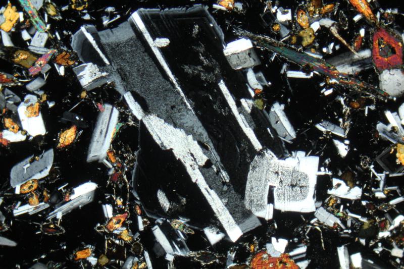
Most phenocrysts are single mineral crystals, but some are compound. Glomeroporphyritic rocks contain apparent phenocrysts composed of mineral aggregates, or clots, called glomerocrysts. Glomerocrysts form when growing crystals are attracted to each other by surface tension and subsequently crystallize and become interlocked together. The thin-section view in Figure 4.45 shows a glomerocryst that contains plagioclase and augite crystals. The finer groundmass is mostly plagioclase and glass. Small plagioclase crystals are tabular with white to gray interference colors.
4.5.2.5 Variable Amounts of Volcanic Glass

Most extrusive rocks contain volcanic glass. Glass is isotropic and so appears black when viewed under crossed polars with a microscope. In Figure 4.46, for example, isotropic glass surrounds crystals that are mostly plagioclase.
Rocks that are entirely glass are holohyaline. Obsidian and tachytite are names for silicic and basaltic holohyaline rocks, respectively. Most obsidian, however, contains tiny microcrystals that give the glass a turbid (somewhat cloudy) look in thin section. Rocks that contain a mix of crystals and glass, like the andesite in Figure 4.46, are hypocrystalline. Rocks composed entirely of crystals, such as the latite in Figure 4.36 and the lunar basalt in Figure 4.47, are holocrystalline rocks. Most holocrystalline rocks, however, are plutonic, not volcanic.
4.5.2.6 Other Microscopic Features
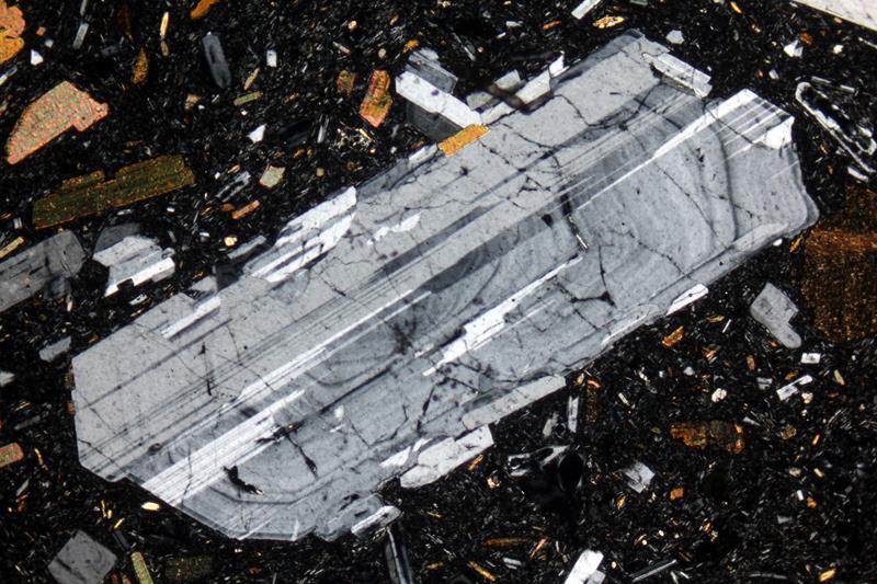
In principle, minerals that crystallize from magma should be homogeneous. Elements will diffuse in and out of growing crystals to maintain chemical equilibrium as temperature changes. Sometimes this does not happen, however, and crystals may become compositionally zoned, like the plagioclase crystal seen in a glassy rhyolite in Figure 4.48. The zoning in this crystal appears as vague rings, sort of like tree rings. In some zoned crystals, zones are more pronounced.
The plagioclase grain in Figure 4.48 contains concentric zones with different compositions. The different compositions have different optical properties and so show different shades of interference colors under crossed polars. This plagioclase grain also exhibits polysynthetic twinning, a kind of twinning involving multiple twin domains that are parallel to each other. Zoned phenocrysts are common in volcanic rocks because rapid cooling does not give crystals time to homogenize. But phenocrysts in plutonic rocks sometimes show zoning as well.

Volcanic glass is unstable at Earth’s surface and, over time, tends to devitrify (crystallize) and turn into minerals. Thus, very old volcanic glass is rare. Silica-rich rocks often develop a felsitic texture (Figure 4.49) composed of remnant glass and extremely small mineral grains called microlites that formed when glass devitrified. Microlites show birefringence but are too small for certain mineral identification. A felsitic matrix also commonly contains crystallites, smaller than microlites, with spherical, rod, or hair-like shapes.
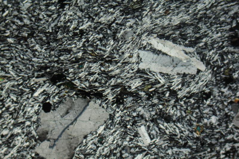
The texture seen in Figure 4.50, a trachytic texture, appears somewhat like a felsitic texture but does not form from devitrified glass. The matrix is composed of subparallel feldspar (sanidine) microlites and their alignment may reflect magma flow at the time of crystallization. This texture is typical of trachytes and chemically similar volcanic rocks.
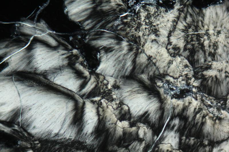
Sometimes glass devitrification produces spherulites – radiating or branching arrays of fibrous or needle-like crystals. Spherulites are common in glassy silicic volcanic rocks, and are most commonly aggregates of quartz and feldspar. Figure 4.51 show spherulites in devitrified glass of a pumice.
4.5.3 Identifying and Naming Volcanic Rocks in the Field
Because identifying different kinds of fine-grained rocks in outcrops, or in hand specimens, is problematic, geologists sometimes use very approximate classification systems. Often, the best we can do when naming volcanic rocks without the aid of analytical instruments, is to note rock color and texture. Rock color depends on the minerals present and their grain sizes. Usually, rocks that contain abundant feldspars and quartz have a light color; those that contain abundant mafic minerals (Fe- and Mg-rich minerals such as amphibole, pyroxene, olivine) have a dark color. The percentage of dark colored minerals is the rock’s color index.
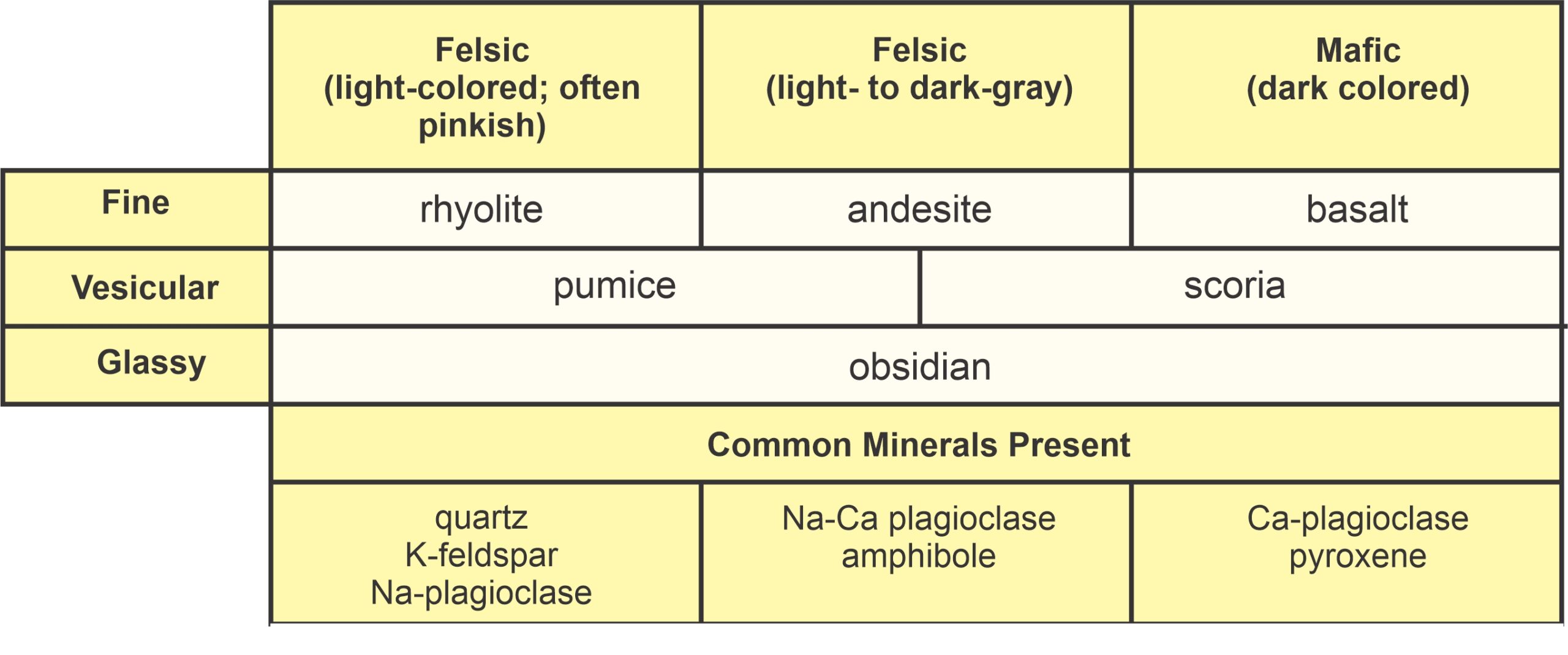
Alkali feldspar, the kind of feldspar that dominates silicic rocks, is often pinkish or tan. Because silicic rocks generally contain alkali feldspar, silicic rocks are generally light-colored (low color index) and may have a pink or tan hue. Mafic rocks are dark-colored (high color index), and intermediate-composition rocks fall somewhere between. Unfortunately, some fine-grained rocks may appear darkly colored, even if they are silicic. Often, the best we can do when looking at rocks in the field is to call them basalt if dark colored, andesite if white or gray, and rhyolite if pinkish or tan. Upon thin section examination, or after obtaining a chemical analysis, the names may have to be corrected. Table 4.1 is a simple naming system that we can use when examining volcanic rocks in the field. The system is based on rock color, and whether a rock is fine-grained, vesicular, or glassy. The bottom part of the diagram lists the (likely) minerals present in rocks of different sorts, although they may not be visible.
4.6 Common and Unusual Volcanic Rocks
4.6.1 Ultramafic Volcanic Rocks
Ultramafic plutonic rocks make up most of Earth, because they make up most of the mantle. Although the mantle is out of our reach, ultramafic mantle samples have reached the surface as tectonic fragments caught up in mountain building or as much smaller xenoliths carried up by magmas. Yet, despite the abundance of ultramafic rocks at depth, ultramafic volcanic rocks are rare.
Ultramafic magmas, which must originate in the mantle, do not reach the surface to produce ultramafic volcanic rocks today. They did, however, reach the surface during Earth’s early history. Thus, we find rare ultramafic volcanic rocks in old Archean shields, and much less commonly in younger terranes. The dearth of young ultramafic volcanic rocks is probably due to Earth’s cooling. The young Earth was much hotter than today’s Earth. Ultramafic magmas crystallize at high temperatures, but when Earth was warmer, the magmas could make it to the surface before they crystallized. Today they cannot, because they are likely to cool and solidify at depth.
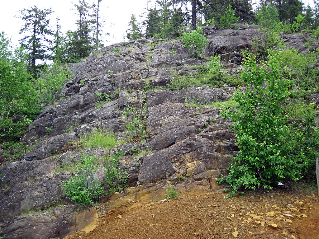
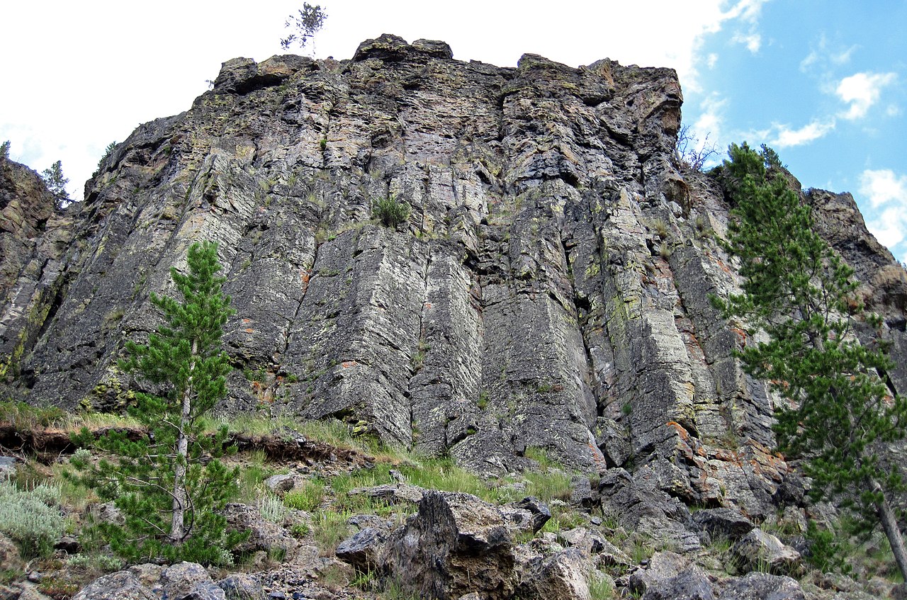
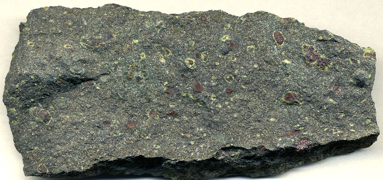
Figure 4.52 is a photo of 2.7 billion year old rocks exposed at Pyke Hill, in western Ontario. These are one of the best studied examples of ultramafic lava flows. The flows are a type of volcanic rock called komatiite, named after its type locality on the banks of the Komati River in South Africa. Komatiites are, by definition, ultramafic volcanic rocks that contain more than 18 wt% MgO. Primary minerals in komatiites include much olivine, one or two Mg-rich pyroxenes (augite, pigeonite, or orthopyroxene), along with chromite, plagioclase, or ilmenite. Rarely komatiites contain amphiboles. All known komatiites have been metamorphosed and some contain prograde minerals such as tremolite, chlorite, talc, and magnesite. Many have altered and contain secondary serpentine, chlorite, or brucite, often with carbonate minerals, that have replaced the primary minerals.


One of the most distinctive things about komatiites is that layers within them commonly display a spinifex texture. This term derives from the shape of needles of a spinifex plant (Figure 4.53). In rocks, spinefex texture appears as long acicular (needle-shaped) crystals of olivine (or pseudomorphs containing altered olivine) or pyroxene that give the rock a bladed appearance. We most easily see spinifex texture on a weathered surface like the one see in Figure 4.54 . Some of the lavas seen in Figure 4.52 display spinefex texture but the photo is not of high enough resolution for the texture to be visible.
4.6.2 Mafic Volcanic Rocks
In contrast with ultramafic rocks, mafic volcanic rocks are widespread. Basalt is the most common variety of mafic rock and the most common volcanic rock on Earth. Basalt flows dominate in oceanic regions, and basalts are found in some continental areas, too.
Most mafic magma is generated by decompression melting of the mantle beneath mid-ocean ridges. Some of this magma erupts on the ocean floor as basaltic lava, but most cools underground, creating gabbros. Small amounts of basalt are also occasionally produced in subduction zones when water released by subducting slabs causes flux melting of overlying mantle.
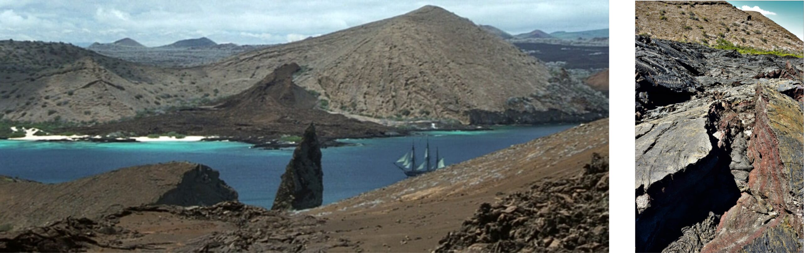
Although most igneous activity occurs at plate margins, basaltic melts may form in plate interiors. Mafic volcanoes and, often, gabbroic (mafic) dikes are commonly associated with hot spots or with continental rifts. For example, the basalt flows in the Hawaiian and Galapagos Islands are products of a hot spot. Figure 4.55 contains two photos of basalt in the Galapagos. The photo on the left shows Bartolomé Island; the photo comes from the 2003 Russel Crowe movie Master and Commander. The photo on the right is a close-up of the lava flow seen in the distance in the larger photo.
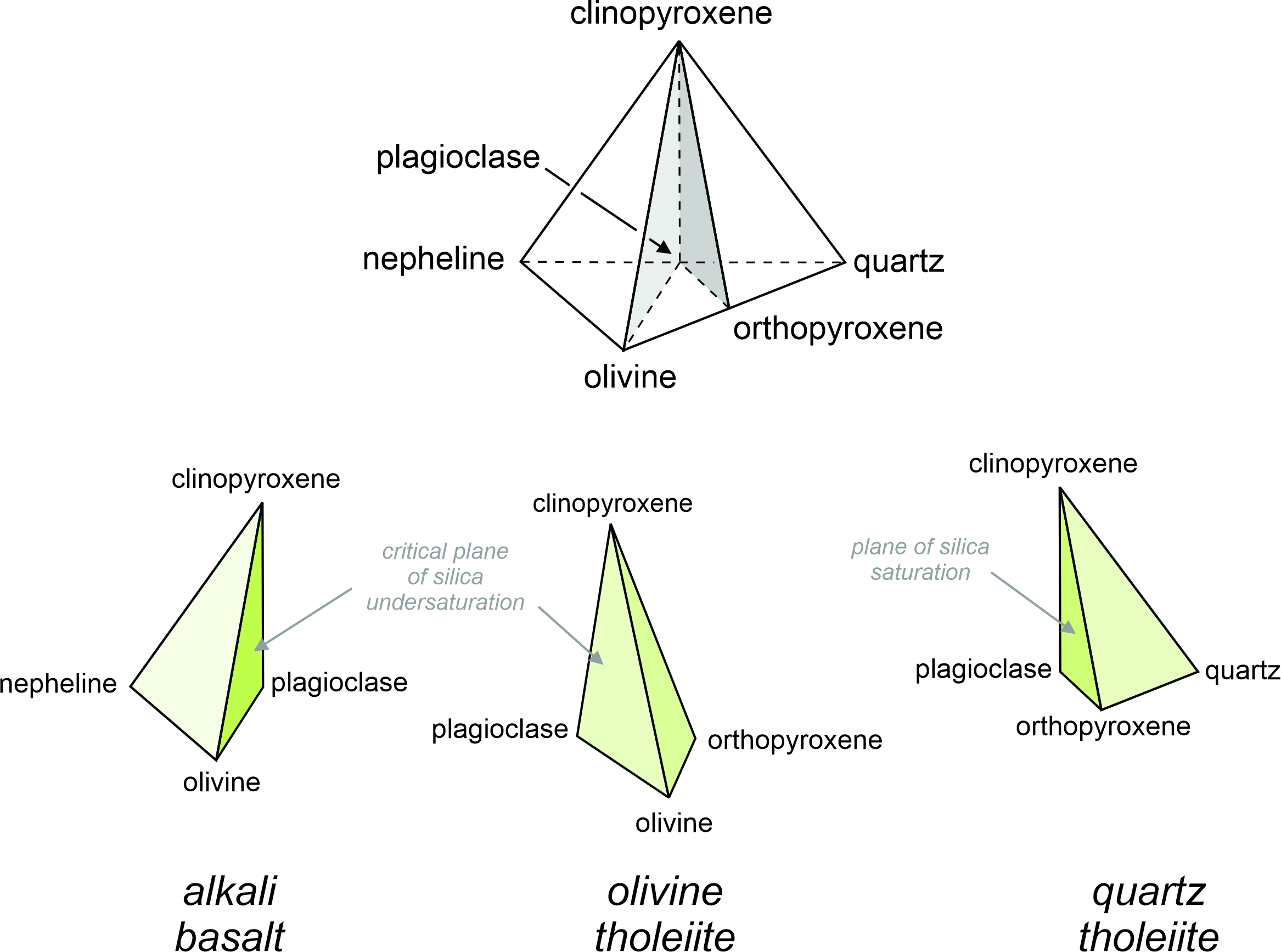
We can visualize basalt compositions and mineralogy using the basalt tetrahedron (Figure 4.56). The tetrahedron has clinopyroxene, quartz, olivine, and nepheline at its corners. Orthopyroxene (which has composition halfway between olivine and quartz) plots in the center of the front edge. And, plagioclase (which has composition halfway between nepheline and quartz) plots in the center of the back edge. The main variables in this tetrahedron are silica content (which increases from left to right), calcium content (which increases from bottom to top), and alkali content (which increases from front to back).
Clinopyroxene, quartz, olivine, orthopyroxene, and plagioclase are the major minerals found in basalts. But they cannot all be present, and basalts fall into one of three categories: alkali basalts, olivine tholeiites, and quartz tholeiites (Table 4.2), separated by the plane of silica undersaturation and the critical plane of silica saturation in the basalt tetrahedron. The three bottom drawings in Figure 4.56 highlight the different kinds of basalt.
| Table 4.2 Common minerals in different kinds of basalt | |
| type of basalt | space common minerals |
| alkali basalt | space olivine, plagioclase, clinopyroxene |
| olivine tholeiite | space plagioclase, clinopyroxene, orthopyroxene |
| quartz tholeiite | space clinopyroxene, orthopyroxene, quartz |
Nepheline never coexists with orthopyroxene, and the critical plane of silica undersaturation separates alkali basalts from olivine tholeiites. Olivine cannot coexist with quartz (or else the two would react to yield pyroxene) and the plane of silica saturation separates olivine tholeiites from quartz tholeiites. Basalts of the ocean floor, most large oceanic islands, and continental flood basalts are tholeiites. Alkali basalts are associated with continental rifting, hotspot volcanism, and are occasionally found on ocean islands. The different kinds of basalts depicted in Figure 4.56 seem straightforward, but basalts can be complicated. Many are so fine grained that mineral identification is difficult, and most are partially to entirely glassy. So, basalts of different sorts may be missing all or some of the minerals in the tetrahedron.
4.6.3 Intermediate and Silicic Volcanic Rocks
Intermediate-composition volcanic rocks – most often andesites, and closely related dacites (Figure 4.57) – are typically associated with subduction zones, but the exact origin of intermediate composition magmas is debated today. Perhaps the debate is because they may form in more than one way. In some places, intermediate composition magmas appear to form by partial melting of mafic rocks during subduction. In other places, it seems that andesitic magma is what is left over after a basaltic magma has partially crystallized. It also is likely that mixing of magmas, crustal melting, and crustal assimilation play important roles in the production of intermediate magmas.
Like intermediate magmas, the origins of silicic magmas are sometimes debated. If partial melting of ultramafic and mafic mantle and lower crust are the source of silicic melts, there must be much leftover mafic material in the source regions. Yet, evidence for the existence of those leftovers is skimpy at best. So, although huge silicic batholiths and large rhyolite terranes exist, it seems inconceivable that they could be products of the partial melting of highly mafic, or ultramafic, parent material. The consensus today is that, although getting silicic magmas from anatexis of mantle or lower crust is possible, many silicic melts come from melting of crustal rocks. As occurred beneath Yellowstone, the heat needed to cause the melting may be carried into the crust by rising mafic magmas that originated in the mantle. This process occurs at hot spots, in rift zones, and in the roots of mountain chains. It may occur elsewhere on a smaller scale.
Intermediate and silicic magmas are rare in oceanic terranes but common on continents. They are most often associated with subduction zones, but also occur at hot spots or in rift zones. These magmas are relatively viscous and often contain high gas contents. So, they tend to erupt explosively, producing ash and other airfall debris that eventually settles and consolidates to become tuffs. Rhyolitic tuffs are arguably the most voluminous of type of continental igneous rock.
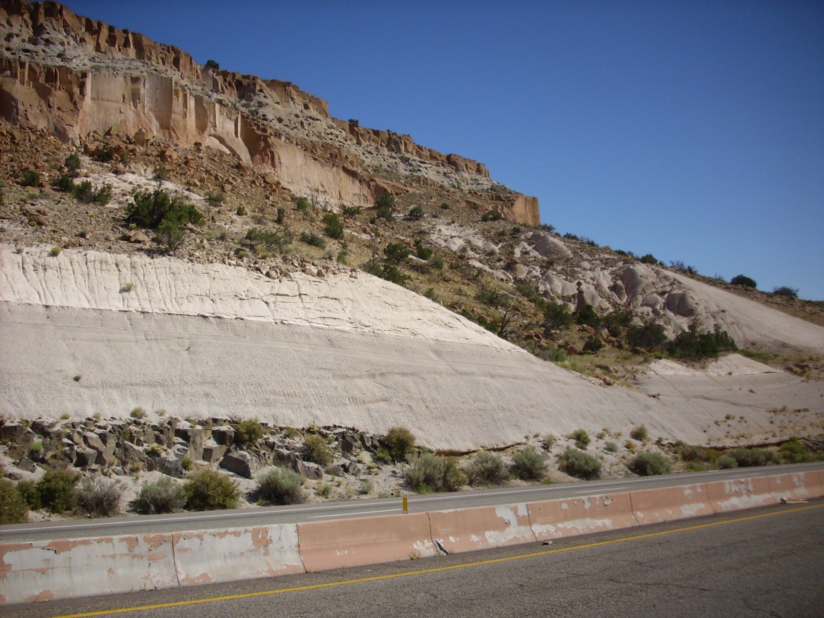
Figure 4.58 is a photo of New Mexico’s Bandelier Tuff – a tuff associated with the Rio Grande Rift. The tuff contains three members, deposited as ash flows at different times 1.85 to 1.05 million years ago, during explosive eruptions that produced the Valles Caldera near Los Alamos. Figure 4.58 shows two of these members, one forming sloping gray slopes and the other exposed in cliffs above. Both have rhyolitic compositions. Bandelier National Monument is very close to where this photo was taken. For a view of the tuff in Bandelier, with its Puebloan dwellings, see Figure 5.14.
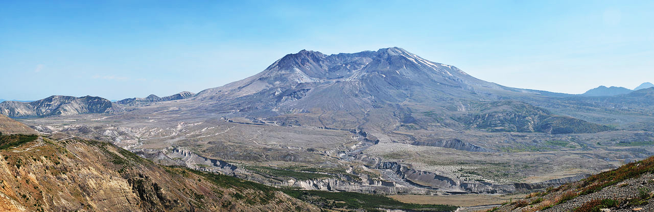
Most rhyolites and andesites erupt to produce stratovolcanoes such as those that we find in the Ring of Fire surrounding the Pacific Ocean. Figure 4.59 (below) shows an example – Mt. St. Helens, an active volcano of the Cascade Range in Washington. Most of the rocks produced by this mountain have been rhyolitic, and this photo shows a small rhyolitic dome that developed in the center of the summit crater. Mt. St. Helens is a typical stratovolcano with a long history. It first erupted about 275,000 years ago. During the past 4,000 years major eruptions have occurred more than a dozen times, including the devastating eruption on May 18, 1980 (described more fully in Chapter 5). Investigations by The United States Geological Survey have concluded that St. Helens magmas originated by flux melting in the mantle, above the subducting Juan de Fuca Plate. Hot magma rose and collected near the base of the crust temporarily before moving up to shallower storage chambers and, ultimately, erupting.
4.6.4 Lava Flows with Intermediate and Silicic Compositions
Generally, high dissolved gas content means that silicic and intermediate magmas erupt explosively. Consequently, effusive eruptions of rhyolitic, dacitic, and andesitic lava, are relatively rare. But after many explosive eruptions magmas may become depleted in gases. So, later eruptions of the same magma may be effusive. Perhaps 10-15% of all lava flows are silicic or intermediate. Examples include the rhyolite flows that have almost filled the Yellowstone Caldera since it formed 640,000 years ago, such as the flow at Obsidian Cliff seen in Figure 4.60. Other rhyolite flows are found west of Yellowstone in the Snake River Plain. The most common occurrences of silicic and intermediate lavas, however, are associated with subduction zone volcanoes. For example, South America’s Andes Mountains contain many andesite flows (intermediate), along with lesser amounts of dacite and rhyolite flows (silicic).
Although most are associated with subduction zone volcanism, andesitic flows are also found on ocean islands. Figure 4.61 is an aerial photo of an andesite flow on Bagana Volcano. Bagana is one of seven active volcanoes on Bougainville Island, in Papua New Guinea, northeast of Australia. The volcano has erupted multiple times during the last 175 years, with major eruptions in 1950, 1952, and 1966. Almost continuous eruptions have been occurring since the early 1970s. Bagana’s andesitic lava flows are sometimes as thick as 150 meters.
As pointed out in Chapter 3 (Section 3.2.2), even if they do erupt effusively, silicic and intermediate magmas may not travel far. Often they produce localized lava domes instead of flows because the magmas are too viscous to travel significant distances. The rhyolite dome on the left in Figure 4.62 is about 650 meters across with steep sides. The photo of Mt. St. Helens on the right shows a smaller silicic lava dome in the volcano’s summit crater in 1982. The dome can also be seen in a more recent photo (in 2009) in Figure 4.59.
4.6.5 Alkalic Volcanic Rocks
Alkalic volcanic rocks are relatively rare. They mostly occur in continental interiors and may be associated with rift zones such as the East African Rift. These rocks are enriched in sodium, and sometimes potassium, compared with other volcanic rocks. Most petrologists use the descriptor alkalic rock for rocks that contain more sodium and potassium than can fit into feldspars alone. These rocks vary quite a bit in mineralogy. If low in silica they commonly contain feldspathoids (typically nepheline), so they may be nephelinites or phonolites of various sorts. With more silica, they may be trachytes (see Figures 4.33 and 4.34).
Although most alkalic volcanic rocks are associated with continental rifting, some are found at hot spots. Figure 4.63 is a photo of a trachyte from Gran Canaria, a hot-spot island. This trachyte, like all trachytes, contains mostly alkali feldspar with small amounts of mafic minerals. Typically these rocks contain light-colored phenocrysts of sanidine (high-temperature alkali feldspar). Trachytes may also contain Na-rich pyroxene and amphibole.
Figure 4.56, earlier in this chapter, introduced alkali basalts. They are alkali-rich and silica-poor compared with other kinds of basalt. Alkali basalts sometimes contain nepheline, reflecting their high alkali contents and relatively low silica contents. Alkali basalts, however, contain essential plagioclase and lack K-feldspar, which distinguishes them from other alkalic rocks.
4.6.7 Carbonatites
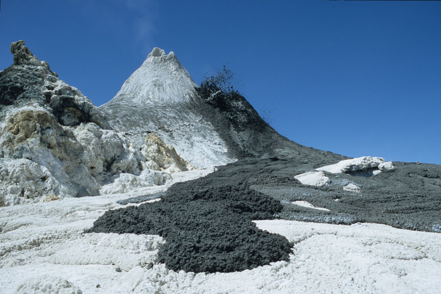
Carbonatites, rare igneous rocks that contain half or more igneous carbonate minerals (calcite, dolomite, siderite, or ankerite), are sometimes associated with more common alkalic rocks. Carbonatites contain less than 20 wt% SiO2, and so are the most silica-poor igneous rocks known. They are, however, for the most part plutonic or subvolcanic rocks. An exception is the active Ol Doinyo Lengai Volcano in Tanzania. Figure 4.64 shows black carbonatite lava flowing from a small cone. When the lava cools, it turns white. See also the photo and brief discussion of this volcano in Chapter 3.
4.6.8 Kimberlites
Kimberlites are a rare type of alkalic rock named after Kimberley, South Africa, where they were first identified as a source of diamonds. These ultramafic rocks occur mostly in diatremes called kimberlite pipes, or in dikes, and less commonly in sills. In many ways they are the equivalent of mica-bearing peridotites. These are coarse rocks, generally brecciated, that may contain primary olivine, phlogopite, garnet, pyroxene, ilmenite, and fragments of the rock the magma passed through during upward movement. Kimberlites, however, often alter and may become highly serpentinized.
Kimberlites form from magmas that originate at depths greater than 150 km, perhaps as deep as 450 km. They erupt at the surface in explosive eruptions powered by expanding CO2 gas. Besides containing diamonds, kimberlites may contain ultramafic xenoliths and thus provide mantle samples for study. Figure 4.65 is a kimberlite sample from the Chicken Park kimberlite in northernmost Colorado. It contains visible red garnets in a sea of green-gray serpentine.
| Chapter 16 (Section 16.2) contains many photos of volcanic rocks in hand specimen and in thin section. If you want to know what they look like, go there. |
● Figure CreditsUncredited graphics/photos came from the authors and other primary contributors to this book. 4.0 (opening photo) Eruption of Kilauea, National Park Service (NPS) |