A virtual field experience examining the crust/mantle boundary
Orientation: Moho Basics
This virtual field experience (VFE) will enable you to explore a unique boundary within the Earth’s lithosphere. You will explore the Mohorovičić Discontinuity, the base of the Earth’s crust. Ultimately, the goal will be to better understand how this boundary provides insight into the evolution of plate tectonics on our planet.
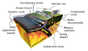
Jules Verne was wrong. No one has ever been to or seen the Earth’s interior. Geoscientists know about its structure in two primary ways. First, through large blocks of rock that have been thrust up onto the outer crust tectonically. Second, through igneous materials that have been erupted volcanically. In this VFE, we will explore the boundary between the crust and mantle, a layer referred to as the “Moho”, for short, or the Mohorovičić Discontinuity, more fully. Before you begin, you can read more about the Moho here.
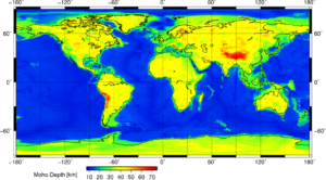
You can get a glimpse of the Moho from the image below, where it is traced out with a green line. Keep in mind that while the Moho averages about 10km deep beneath oceanic crust, it can be as much as 70km deep beneath continental crust.
The Moho’s depth varies depending upon geographic location. In the geophysical map below, the depth of the Moho is evidently much greater in some places than it is in others. Can you see where it is shallowest and where it is deepest?
Moho: How Deep Is It?
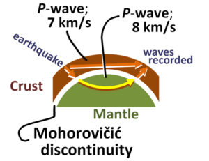
The Moho is very identifiable using seismic data. Seismic waves are produced by energy released by earthquakes and other disturbances. Seismic waves are not unique to earth, Mars has seismic waves also that travel through the planet, as does our natural satellite, the Moon. On Mars, much of this activity is caused by wind. Wind can also cause seismic disturbances on Earth, but to detect anything at depth like the Moho, earthquake data is necessary. On any of these bodies, we can use seismometers to measure the waveforms and differentiate between them. P-waves, are also known as “Primary Waves” (first to arrive at a seismic station from the focus of an earthquake) or “Pressure Waves” (they push and pull the medium in which they travel as the energy propagates). In the image to the right, the P-wave velocity increases significantly at the Moho, from 7m/s to 8m/s. This sudden velocity change shows us that at the Moho, there is a significant change in the density of the material. The layer beneath the crust (the mantle) is more dense than the crust, and so the P-waves speed up when they enter it.
Moho: What is It?
A Trip to Oman: The Semail Ophiolite Complex
In this first VFE, our purpose is to introduce some material that we will revisit later, but to do so in a very cursory way. Thus, our main goal is to help you learn to make observations, sketch them, and relate them to actual processes that can be modeled and then explained. So, this may feel like an advanced activity, but try not to let that feeling get in the way of what the questions are asking you to do. Your main focus should be answering each question in a way that is satisfactory in your mind…not worrying about what you think your instructor wants.
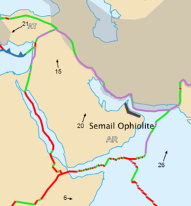
So… Off to beautiful, magical, Oman! Below is a geological map of the Semail ophiolite complex. Please read about this unique rock complex and how it is being used by some researchers to answer important questions about microbial metabolism as it relates to geochemistry (life and geology interacting!). More purely geologically, the Semail ophiolite offers researchers an opportunity to investigate low-temperature metamorphism: how certain minerals interact with water.
An “ophiolite” is simply a chunk of oceanic crust thrust up onto land. Please explore how an ophiolite makes its way onto land at this link.
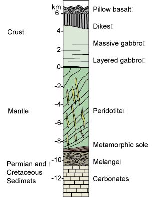
An ophiolite, as a section of oceanic crust, has a particular model of formation resultant structure. At right is a model of the stratigraphic and structural layering of the Semail Ophiolite.
You can see here that there are a bunch of new terms for you. For now, just know that these terms refer to either different kinds of rocks or features. For the moment, the only thing to focus on is that boundary between the peridotite (mantle) and gabbro (base of the oceanic crust).
Field Sketch: The Semail Ophiolite
Begin exploring this image and produce a “field drawing” of the ophiolite. Be sure to include in your drawing:
The “OASIS” method:
Orientation
Annotation
Scale
Information
Sketch what you see!
Here is a nice introductory video on making geological field sketches:
Below, you will see a GigaPan image of the Semail Ophiolite. You can view the image in its native location here. You are looking at a very rare and unusual mountain. Pan around, zoom in, and see if you can find the Moho. Hint: The boundary is located in a place where you can see the lighter-colored lithospheric upper mantle rocks separated from the darker-colored crustal gabbros.
Once you complete this, annotate your drawing by identifying the main boundary between the mantle and crustal rocks and what you see at this field site.
Here is the field site for you to sketch below:
Where’s the Moho?
Field Specimen 1: Peridotite
So, you decide to climb up to the base of this mountain to collect a specimen to compare the rocks below and above the MOHO. While climbing, you pick up this lovely piece of peridotite along the way. Initially, you note that the peridotite sample is “coated” with a film of basalt (kind of like a chocolate-covered peanut):
Make some observations of the specimen above after reading about the rock Peridotite.
Peridotite: Phaneritic or Aphanitic?
Field Specimen 2: Gabbro
After taking a break and a long drink of water, you continue to venture up the mountain to areas above the Moho. In fact, you climb directly to the top! What a view!
Once you’re there, you look around for some good specimens. You find this one:
What do you notice right away that’s very different? You can click on the numbers on the rock also – they will give you some clues.
Gabbro: The Dominant Minerals
Leaving the Field: Considering the Moho
After visiting the Semail Ophiolite Complex, drawing the Moho as it appears in outcrop, and considering the specimens you collected, you leave with a better understanding of a part of the Earth’s interior that is otherwise invisible to you. You have learned that the Mohorovičić Discontinuity is a real seismic boundary within the Earth. It is located at different depths within the Earth’s lithosphere. In oceanic lithosphere, it is shallower and in continental lithosphere, deeper. It exists because their densities are different due to changes in physical and chemical attributes, which are a function of their different compositions.
You might be left with some questions:
1) Is this compositional boundary deep within the Earth so distinct everywhere?
Actually, the gigapan you sketched above is a bit misleading! The Moho is considered to be a transitional zone between the crust and mantle that is, on average, about 500m in thickness. It looks very crisp and neat in the gigapan. How did you draw it in your sketch?
2) Has the Moho always existed?
Probably not, but we really do not know.
3) Does the Moho exist everywhere?
It does not! It is noticeably absent under volcanic island arcs. This is due to the process of delamination (separation), the detachment and descent of lower crust into the asthenosphere, possibly due to lateral flows of mantle material due to subduction. Japan is an example. The Philippines and New Zealand are others. Interestingly, the Moho is nice and crisp under the eastern United States. Considering that this region is composed of island arcs that accreted onto the ancestral continent between 460 Ma and 250 Ma, this might be surprising. One hypothesis that attempts to explain this suggests that once the volcanism ceases, so does the delamination of the lower crust. Under island arcs like Japan, there is no Moho due to delamination due to active volcanism and the processes that feed that. Under the eastern United States, a passive margin, there is no volcanism. So, the lower crust is wedded crisply to the upper mantle.
The Moho in Earth’s History
Much about the evolution of plate tectonics remains unknown. It is an active field of study. Seismic data, particularly in the form of seismic tomography (kind of like CAT scans of the Earth), is rapidly filling in our knowledge of the current situation. How we see our planet’s interior today, coupled with what we know of its past from the rock record, is giving scientists the ability to look back into these earlier times.
The Moho plays a role in this. Is characteristics tell us important things about the Earth’s past and its present, their similarities and differences. As far as we know, there has been a Moho if there was solid crustal material in existence. Its depth and even the rocks on either side of it may have changed with time and the evolution of plate tectonics. What has not changed is the nature of the boundary – it is a disontinuity between two layers of distinct densities that result from relatively sudden changes in physical and chemical properties.
For Further Reading
King, Hobart (2020). Peridotite. Geology.com. Retrieved from: https://geology.com/rocks/peridotite.shtml
King, Hobart (2020). Mohorovičić Discontinuity. Geology.com. Retrieved from: https://geology.com/articles/mohorovicic-discontinuity.shtml
Rock Powered Life (2020). Semail Ophiolite, Oman. University of Colorado, Boulder, Rocker Powered Life. Retrieved from: https://www.colorado.edu/lab/rockpoweredlife/research/theme-i-field-investigations/samail-ophiolite-oman
Volcano World (2020). Ophiolites. Oregon State University Volcano World. Retrieved from: http://volcano.oregonstate.edu/ophiolites