A virtual field experience via gigapixel panoramic images

Explore these sites in Shenandoah County, Virginia. This virtual field experience will “take you” to the northern Shenandoah Valley near Strasburg, the northern Massanutten Range, and the Fort Valley. All these sites show rock outcrops that are part of the regional-scale Massanutten Synclinorium.
A synclinorium is a large down-fold (where the limbs overall dip inward toward a central fold axis), with smaller-scale synclines and anticlines superimposed on it. The sedimentary strata on the west side of the structure are the same on the east side of the structure, and those are older than the strata exposed at the center of the structure. Differential erosion of the strata has preferentially etched away at the limestones, shales, and graywackes, making low-lying valleys: the Shenandoah Valley and its eastern counterpart, the Page Valley, and the Fort Valley in between. The mountain ridges of the Massanutten Mountain system are all underlain by a resistant quartz sandstone unit that stands up better to the forces of weathering.
Here is a Google Map showing where this VFE’s eight principal stops are located (in blue), plus logistical information if you wanted to visit in person (in red), and supplementary stops (in yellow):
The eight principal stops on this field trip tell a story (1) of shifting sedimentary conditions in the Appalachian sedimentary basin over the course of two episodes of passive margin sedimentation and two orogenies and then (2) all of those same strata being deformed during a third orogeny. The two passive margin episodes are marked by carbonate deposition, while the two early (basin-adjacent) mountain-building episodes that contributed clastic sediment are the Taconian and Acadian orogenies. The final mountain-building episode that turned the basin into part of the mountain belt was the Alleghanian Orogeny.
To explore this story’s rock record, the stops below are shown with gigapixel panoramas of outcrops and hand samples. Each is “explorable” by you as the virtual field tripper: you can zoom in, pan around, make observations, pose potential interpretations, and then look somewhere else to test those ideas. The images are organized by stratigraphic and structural sequence. We begin with the oldest strata, work our way up through the available outcrops to the youngest strata exposed in the region (considering what they have to tell us about depositional conditions and active/passive margin conditions through the early to mid-Paleozoic) and then look at deformation associated with the late Paleozoic Alleghanian orogeny.
Stop 1: Conococheague Formation exposed at Mulberry Run
The oldest rock unit on our trip is the Cambrian-aged Conococheague Formation. It is a limestone with some secondary dolostone. It features primary sedimentary structures including ooids, cross-bedding, and stromatolites.
Easternmost portion of the south-facing outcrop:
A little bit further to the west: Can you find the stromatolites?
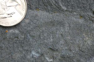
Some of the Conococheague, particularly at the west end of this outcrop, show small ooids. It’s oolitic limestone. Ooids forms due to chemical precipitation of calcite from seawater, building up on small nuclei particles, layer on layer, like a hailstone. They get rounder as they get larger, and the reason they have such even layering is they are gently shifted around from moment to moment by waves. If we look at where ooids occur today, we find them in shallow tropical marine settings, such as the carbonate platform of the Bahamas Islands. Therefore, using uniformitarianism, we can infer that when the Conococheague Formation was deposited, Virginia must have been a carbonate platform where the seafloor was within reach of the waves – moderately shallow, in other words.
Here is a Petri dish full of ooids, the spherical building blocks of oolitic limestone:
So: ooids only form in moderately shallow water, as their formation requires gentle shifting by the waves. But stromatolites too are an indication of shallow conditions, as the microbial mats were photosynthetic, and needed sunlight in order to grow. Light doesn’t penetrate to great depths through the water, so stromatolites “corroborate the testimony” of the ooids, backing up the interpretation of the Conococheague Formation as being indicative of conditions we would expect on a shallow tropical carbonate platform.
Going further: Here are some samples of stromatolites from other sites, similar to those in the Conococheague Formation:
| (Credit Ariel Anbar) |
Two views of Shark Bay, western Australia, a place in the modern world where stromatolites are thriving; geologists infer the depositional setting of the Conococheague Formation would have been similar:
(Credit Ariel Anbar) |
(Credit Ariel Anbar) |
Q: What is the “take home message” regarding our interpretation of the depositional conditions that prevailed during the deposition of the Conococheague Formation and related Cambrian carbonates?
Stop 2: Tumbling Run (New Market, Lincolnshire, & Edinburg Formations)
There are three formations exposed at a famous outcrop, east of Tumbing Run on Fisher’s Hill. The uppermost end of the outcrop (stratigraphically, the lowest/oldest layers) shows the contact between the New Market and overlying Lincolnshire formations:
The strata at Tumbling Run change as you walk up-strata (downhill) eastward through the outcrop: the proportion of carbonate decreases, and the proportion of clay and silt increases. They also get darker.
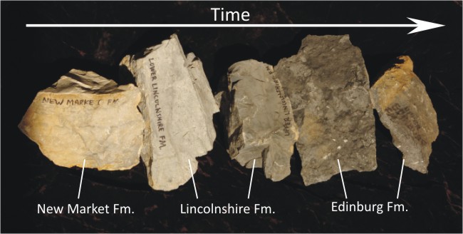
In the Edinburg formation, there are a couple of layers that weathers away much more easily than the limestone above and beneath them! Upon closer inspection, these layer consists of tan to yellowish clay, very crumbly to the touch. Each is a bentonite layer, a layer of clay that has resulted from the weathering of a volcanic ash deposit.
Near here is another bentonite of extraordinary size. In North America, it is referred to as the “Millbrig bed.” In Europe, a similar bentonite layer is referred to as the “Big Bentonite.”

The presence of bentonites indicates that volcanic ash was periodically being added to the sediments of the carbonate platform.
Q: What is the overall story recorded by the outcrops at Tumbling Run? (Hint: it changes from bottom/older to top/younger.)
As a tangential observation, it’s cool to note that in Tumbling Run itself, Ca and CO3 ions (dissolved from local source rocks such as those displayed in the outcrop) reprecipitate to form fresh deposits of travertine, like this:
Stop 3: Lower Martinsburg Formation on Route 11
This is a quick stop to see an outcrop of rock that is intermediate between the strata of Tumbling Run (Stop 3) and the strata we will see at Stop 4. There is limy shale of the Martinsburg Formation exposed at the intersection of Funk Road and Route 11.
This is stratigraphically higher than the Tumbling Run site’s uppermost strata:
This outcrop shows us that the story told at Tumbling Run (of less carbonate and more mud) continues. Along with the bentonites, this shift from carbonate to siliclastic sediment is the first clear signal that the Taconian Orogeny has started to the east.
On the other side of the Massanutten Synclinorium, there is a sweet fold and and some very well developed slaty cleavage developed in this same set of strata. If you want a bonus stop, consider visiting the South Page Valley Road with this video:
Stop 4: Upper Martinsburg Formation on Millner Road:
The transition from 100% carbonate to 100% clastic sediment is complete by the time we get to Stop 4. This shift is a signal that a signficiant new source of clastic sediment (i.e. a mountain range) exists by the late Ordovician period of geologic time, and is shedding lots of sand and mud into the basin.
The basin itself has deepened, presumably due to the edge of the ancestral North American crust flexing downward upon being loaded with the Taconian mountain belt. In this deep basin, turbidity currents avalanched downward, bringing sand and mud from their mountain source area deep into the water to slowly settle out.
As evidence of this mode of deposition, here we see very steeply dipping strata of graywacke and shale (lacking any calcite), exhibiting graded bedding. This alternation between coarser and finer clay-rich clastic sediment and the characteristic graded bedding is interpreted as being due to deposition by turbidity currents:
Here is a graded bed from the Martinsburg Formation as seen in hand sample:
Another sample of graded bedding from the Martinsburg Formation, but cut into four pieces to show four sections through this single Bouma sequence:
Q: How can you tell that the two previous GigaPans are shown “right side up?” Explain.
Overall, then, this stop shows us a great example of “flysch” (deep marine clastic sedimentation, where the sedimentary source is an adjacent mountain belt).
Before we leave, though, let’s stroll down the road for a couple of minutes to check out an outcrop that shows bedding/cleavage relationships in Martinsburg Formation:
Bedding here dips moderately to the right (east), and cleavage dips very steeply to the left (west). Though deformation isn’t our focus at Stop 4, it’s worth it to make note of it when we see it. Both the tilting of the sedimentary layers and the cleavage are both later tectonic signatures that overprint the original sedimentary story. Outcrops like this one tell two stories for the price of one! (They are “palimpsest” in character.) Though right now our focus is on the sedimentary signature of the Taconian Orogeny, the deformational structures should be noted as well. We will return to the deformational “overprint” story when we get to Stop 8.
Reiterate key points from stop 4 with a bonus stop on the other side of the synclinorium:
Stop 5: Massanutten Formation at Passage Creek
Now it’s time to enter the Massanutten Mountain system and the Fort Valley, by way of the narrow gorge that Passage Creek has carved below Buzzard Rocks. By the time we get to stop 5, the deepwater turbidites of the late Ordovician Martinsburg Formation that we saw at Stop 4 have given way to cross-bedded quartz sandstones of the Silurian-aged Massanutten Formation. The shift in sedimentary rock signals a shift in depositional setting. Let’s examine the new rock outcrops and think about what sort of setting they might have accumulated in.
Outcrop #1 adjacent to Fort Valley Road, in the George Washington National Forest:
Don’t let the brownish color of that outcrop throw you off – that is just surface staining by iron oxide; a thin veneer of rust on the outcrop surface that gives a false impression of the bright white rock’s true color. As proof, consider this hand sample #1 of Massanutten Formation quartz sandstone:
So we have a quartz sandstone (a quartz arenite) that shows pretty good sorting and is dominated by the hard, chemically-stable mineral quartz. The individual grains vary between rounded and subangular in shape. So this is a fairly mature deposit of sediment. But what about primary sedimentary structures? Consider sample #2 of Massanutten Formation here, showing cross-bedding:
Outcrop #2, up the hill from outcrop #1: Can you find cross-bedding here?
Q: Compare Massanutten Sandstone hand sample #2 to outcrop #2. Both show cross-sectional views of beds of sandstone. In each case: what way (what direction) was the current flowing when these strata were deposited (from left to right, or right to left)? What structure tells you this? Explain.
What sort of depositional setting could produce layer after layer of cross-bedded quartz sandstone like this? One interpretation is a vast braided river system, advancing outward over the now-filled-up flysch basin. The Massanutten Sandstone correlates with the Tuscarora Formation sandstone to the west, and so a tremendous amount of quartz sand was required to make such an extensive deposit.
Further west, an intervening formation, the red bed “molasse” of the Juniata Formation, occurs below the Tuscarora, recording advancing deltas, rivers, and floodplains. In the Massanutten Synclinorium, there is no Juniata, implying perhaps a local unconformity between the Martinsburg Formation and the Massanutten Formation.
Primary sedimentary structures such as cross-bedding survived long enough to be lithified, but other more subtle structures may have been lost to bioturbation. Trace fossils indicate that there were animals disturbing the sediment, too. For instance, explore these trace fossils on a slab of in the Massanutten Sandstone: You’re looking down on the bedding plane here, and the blue lines are annotations showing the trace fossils. They track together; play with it a bit to “train” your eye to see these structures:
So there were creatures burrowing in the sediment at the bottom of this braided river system, prior to lithification.
Now, once again, let’s briefly touch on deformational observations that can be made at this stop. As with the cleavage we observed at the end of Stop 4, these are the result of the late Paleozoic Alleghanian Orogeny. The overall regional structure (the Massanutten Synclinorium) is a result of that final mountain-building event. Its shape is hinted at by these two outcrops in Passage Creek:
| On the east side of the syncline, the strata dip to the west: | On the west side of the syncline, the strata dip to the east: |
This location is essentially at the axis (or “hinge”) of the Massanutten Synclinorium: the line of greatest flexure of the strata. Those east of us dip downward to the west; those west of use dip downward to the east. Our structural perspective is much like that of an ant at the bottom of a canoe, somewhere close to the stern: From our position, the layers of the Massanutten Formation move out and up, getting steeper the further away from us we look, right up to the crest of the mountain ridge.
As proof of that, consider these two views of Buzzard Rocks, the cliffs above and to the east of the outcrops we have just examined:
The point of devoting a bit of your attention to Buzzard Rocks is to note how very steep the beds of Massanutten Sandstone are at that location – almost vertical! (Did you find the rock climber on one of the cliffs in the left image?)
Stop 6: Helderberg Group limestones exposed on Fort Valley Road:
There isn’t too much to see at Stop 6, and indeed it’s not very safe to actually visit these outcrops in person, as there’s nowhere safe to stand on the road. But they are outcrops of important rock layers for our overall story, so we want to make time for them. And there’s no danger of being hit by a virtual speeding car on a virtual field experience!
These limestone strata are stratigraphically above the Massanutten Formation, and like the Martinsburg Formation outcrops at Stop 4b, this rock shows prominent cleavage due to post-depositional tectonic squeezing (during the Alleghanian Orogeny):
Next, let’s focus on a cleaner slab of the Keyser Limestone, one of the formations within the Helderberg Group. Explore it for copious fossils; what marine invertebrates can you identify here?
These fossils help us establish the relative age of the Helderberg Group as late Silurian to early Devonian. The boundary between the two periods (based on conodont fossils) is found near the top of the Keyser Limestone.
So there doesn’t appear to have been much sand or mud being deposited here during the early Devonian… What does that imply about the presence or absence of nearby mountain ranges?
Q: Taken together, what do the Massanutten Formation and Helderberg Group have to say about depositional conditions during the Silurian and early Devonian? How does this relate to what we saw in the Martinsburg Formation? Explain.
Stop 7: Mahantango Formation
So if a return to carbonate deposition (Stop 6) implies that there are no longer nearby mountains to serve as a source of clastic sediment, what does it mean when clastic sediment begins to show up again in the mid-Devonian? That’s the question that the Mahantango Formation should have us pondering….
Here’s a black shale outcrop at the intersection of Fort Valley Road and Ramsey Road.
Clearly, the beds are thin, and the sediment is fine, and the color is dark: these are deep-water shales. Where’s that sediment coming from, though? It turns out that phase 2 of Appalachian mountain building, the Acadian Orogeny, has gotten underway, and it’s producing some sediment that has made it out to this location (in the future Fort Valley) to be deposited.
As with previous formations, organisms are living in this sediment. They left their traces…
Mahantango Formation showing trace fossils (orange-colored tubes), Fort Valley Road:
An outcrop of Mahantango Formation, showing characteristic carbonate nodules:
These nodules can get huge, up to 2 meters across. They are formed through diagenetic processes, and should not be considered as primary sedimentary structures. For whatever reason, they formed in the Mahantango Formation, but not other local shale units. So they are distinctive marker features, unique to the Mahantango. Here’s one of the big ones:
Mahantango Formation showing intersection of bedding and cleavage, with both body fossils and trace fossils, exposed near Trinity Church:
Mahantango Formation sample showing a large straight nautiloid fossil:
Mahantango Formation outcrop showing Zoophycos trace fossils:
Another Mahantango Formation outcrop showing Zoophycos trace fossils:
Mahantango Formation sample showing a nice example of the Zoophycos trace fossil:
Mahantango Formation sample showing a shell-rich horizon:
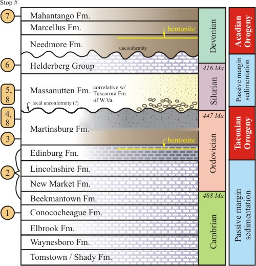
 A conceptual stratigraphic sequence through the strata of this VFE, offering a tectonic interpretation in the right column.
Much of the Mahantango is fairly featureless black mud, with bedding rarely spotted except in shell-rich horizons like the one pictured above. These layers are thought to be storm deposits, where short-lived high-energy conditions took brachiopod shells from shallower places and tumbled them down into the deep, dumping them en masse and leaving them in an undisturbed state thereafter.
As a summary: for the second time in this trip, we’ve seen a transition from passive-margin carbonate deposition to tectonically-induced clastic sediment deposition. A new orogeny had intiated by the mid-to-late-Devonian.
Let us conclude our examination of the stratigraphic of this region by summarizing everything in a simplified stratigraphic column: the sequence, names, and lithologies of the various geologic layers are shown, as well as their timing within the appropriate periods of the geologic timescale, and finally each is marked with long-term tectonic interpretations on the far right.
Q: How do the strata of the Mahantango Formation relate to the presence or absence of mountain-building during the late Devonian? How does this relate to what we saw in the Massanutten Formation and Helderberg Group? Explain.
Stop 8: Veach Gap, to see deformation induced by Alleghanian mountain-building
Though the overall structure of the region is synclinal (youngest strata in the middle; oldest strata on the flanks of the fold), there are smaller-scale anticlines and synclines superimposed on that larger structure. The anticlines in particular weather out well at a small water gap in Little Crease Mountain. This gap is called Veach Gap.
Here are four views of the anticlines exposed at Veach Gap (all are folds within the Massanutten Sandstone):
3D model of one of the Veach Gap anticlines:
As a bonus, here’s an anticline developed in Needmore Formation shale, further south in the Fort Valley. Note the prominent cleavage “fan” superimposed on the sedimentary layering:
All of these structures challenge us to explain them by invoking the principle of original horizontality – these strata were originally deposited within a few degrees of horizontal. The fact that we see them contorted into such extraordinary positions now implies that they must have been deformed at some time after they originally formed.
The folds we see today (as well as the tectonic cleavage, which forms due to pressure solution) is evidence these rocks got seriously squeezed at some time after they were deposited and lithified. The thing that caused the compression was the tectonic merger of ancestral North America with ancestral Africa (then the leading edge of the Gondwana supercontinent).
As ancestral Africa and North America converged, the Iapetus Ocean was snuffed out, and the resulting mountain belt grew upward and laterally, overtaking the sedimentary basins that formed during the earlier Taconian and Acadian events. The former mountain-adjacent sedimentary basin was now incorporated into the Alleghanian mountain belt’s fold and thrust belt; i.e., the future Valley & Ridge geologic province. Meanwhile, Blue Ridge rock was arched upward into a vast anticlinorium, and thrust upward and westward. The strata of the eastern Valley & Ridge province were compressed, causing them to fold into the enormous Massanutten Synclinorium, as well as undergoing penetrative pressure solution, particularly in shaley units, giving them a slatey cleavage.
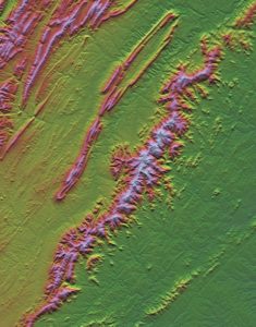
Finally, weathering erosion went to work on this landscape of deformed rock, etching out some rock units preferentially relative to their neighbors. The Massanutten Sandstone, now folded into a crinkly shape, stood up tough against these forces. As the shales and limestones above it and below it were eroded away, it gradually rose above the landscape to make the long, sinuous form of Massanutten Mountain.
Here is a 3D model showing some of the terrain features that resulted from this differential weathering:
Thanks for exploring with us on this virtual field experience!
Chapter Contents
- 1 Stop 1: Conococheague Formation exposed at Mulberry Run
- 2 Stop 2: Tumbling Run (New Market, Lincolnshire, & Edinburg Formations)
- 3 Stop 3: Lower Martinsburg Formation on Route 11
- 4 Stop 4: Upper Martinsburg Formation on Millner Road:
- 5 Stop 5: Massanutten Formation at Passage Creek
- 6 Stop 6: Helderberg Group limestones exposed on Fort Valley Road:
- 7 Stop 7: Mahantango Formation
- 8 Stop 8: Veach Gap, to see deformation induced by Alleghanian mountain-building