This case study presents a single image and challenges you to interpret it. This diagram shows a geological cross-section through rocks of a park in Extremadura, Spain.
Cross-sections give us a “sideways” view into the structure of a region, showing the variation of rock units with depth as well as distance. They are essential tools for interpreting geological histories.
So examine this diagram. How many geological events can you postulate having happened, in order to produce the sequence of rocks and structures seen here?
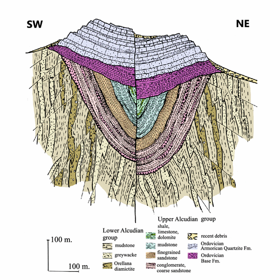
Modified from a figure by J.J. Álvaro, S. Jensen, and T. Palacios.
Here is one possible answer, starting with the oldest units (at the bottom of the diagram):
| 1 |  |
Once upon a time, there was a sedimentary basin where most of the time, mud was deposited. According to the figure’s explanation, this mud would go on to be preserved as the “mudstone” of the Lower Alcudian Group. The exact nature of this basin isn’t clear from the data available to us, but depositing mud requires calm water. Fast moving water keeps small particles moving rather than laying them down, so probably this was a deep setting, perhaps a deep marine basin. That mud had to come from somewhere, so the presence of the mud deposit implies the weathering and erosion of rock, somewhere else. |
| 2 |  |
Periodically, turbidity currents would bring in layers of dirty sand. Turbidity currents are gravity flows of sediment and water, and they tend to hug the bottom of the ocean due to their density. They can travel laterally for substantial distances before slowing and depositing their sediment, often in graded beds. This would later lithify to greywacke. (Usually this word is spelled graywacke in America, and spelled with an ‘e’ in Europe. Since this is a European example, we’ll retain the source nomenclature.) |
| 3 |  |
At some point, either a glacier dumped a bunch of debris in, or there were some submarine landslides that resulted in an exceptionally poorly sorted deposit of diamictite. (We can’t tell from the data available here whether the clasts in that diamictite are faceted and striated or not; that would allow us to distinguish whether a glacier was responsible for the diamictite.) In unfaulted sections, there are two layers of diamictite, separated by mudstone; so whatever process made the diamictite, it must have happened twice. |
| 4 |  |
Then there was an time of folding and thrust faulting, probably accompanying an episode of mountain-building. Roughly speaking, and with the diamictite acting as our marker unit, the strata were warped into what appears to be a regional antiform in structure. The strata would not have been as steeply inclined then as they are now, so let’s call this a broad antiform. (I use the term “antiform” instead of “anticline” here because we don’t have information about the “paleo-up” direction of these Lower Alcudian strata. Strictly speaking, anticlines preserve superposition age sequences – youngest is “up” — but antiform is a more agnostic term; it implies that the strat could young in either direction.) |
| 5 |  |
This tectonic squeezing resulted in uplift, subjecting our now-near-vertical strata to a time of erosion. The mudstone, greywacke, and diamictite layers were truncated against the ancient Earth’s surface. (This is the first step in making an unconformity.) |
| 6 |  |
Time went by and subsidence occurred, allowing sea level to creep back up and over the site. Higher-energy fluvial or shoreline (delta) deposits were laid down. Based on the lens-shaped deposits of conglomerate within the coarse sandstone, it looks like this was either terrestrial or transitional. The base of the unit makes an angular unconformity with the layers described in steps 1-5. |
| 7 |  |
On top of that is a layer of fine-grained sandstone, perhaps indicating that the next step was sand being deposited on a beach or in a nearshore marine setting. |
| 8 |  |
On top of that is a layer of mudstone, implying that deposition shifted back to a more offshore setting, and… |
| 9 |  |
Topping that is a layer of limestone, dolostone, and shale – the most offshore facies yet. We can now apply our understanding of stratigraphy in relating the deposition of these different types of sediment. In total (steps 6,7,8, and 9: the Upper Alcudian Group), this package represents a classic fining-upward transgressive sequence. |
| 10 |  |
Then another episode of tectonic compression happened, folding all these layers into a big syncline. |
| 11 | 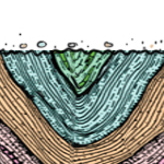 |
Once again, this uplifted the edges of some of the layers to the surface, where they were eroded. (We’re working our way into a second unconformity.) |
| 12 |  |
Again, subsidence and/or sea level rise (during the Ordovician, according to the figure’s explanation) brought deposition back to the site, resulting in the “Base” Formation. An angular unconformity exists now between the base of the Base (see what I did there?) and the underlying steeply-dipping strata of the Upper Alcudian Group. |
| 13 |  |
Based on truncation of some of the upper layers of the Base Formation against the overlying unit, I’m guessing there was another round of erosion. This was not as extreme an episode of erosion as the two we’ve seen previously, apparently lacking any significant tilting or major uplift. |
| 14 |  |
Deposition resumed anew, with layers of quartz sand, also during the Ordovician. Later this will be lithified and apparently metamorphosed to make the Amorican Quartzite formation. This makes an disconformity with respect to the underlying Base layers. |
| 15 | 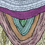 |
Then there was a little bit of folding (pretty subtle compared to its predecessors), again affecting all layers, but most noticeable in the non-horizontality of the Ordovician package. Again, it’s taken on the form of a syncline. |
| 16 |  |
Then faulting down-dropped the northeast side relative to the southwest. |
| 17 |  |
Then (or plausibly accompanying step 16) uplift brought it all above the surface, where erosion went to work again, breaking down the mountainous outcrop and laying down temporary (?) deposits of Recent debris on the flanks of the mountain. |
Seventeen steps are needed in order to generate the succession and position of the rock units of this part of Spain. Were you able to key in to all of them?