Outcrop of the Silurian Tonoloway Formation, located along Corridor H (US48) in West Virginia. This formation is a part of the Tippencanoe Sequence.
KEY CONCEPTS
After reading this chapter, students should be able to:
- Identify and describe the three North American cratonic sequences;
- Describe the stages of the Wilson Cycle.
- Distinguish between sea level transgression and regression.
- Describe the various Systems Tracts that comprise a sequence.
Note: This study is best understood after spending time studying Sequence Stratigraphy basics. For a primer, please read: Stratigraphic Tools: Basic Sequence Stratigraphy.
Sequences of strata in ancient Eastern North America
The Appalachian region of the United States east coast provides an excellent record nearly the entire Paleozoic Era in its rock record. A drive along Corridor H (US 48) through eastern West Virginia will start in the Cambrian carbonate strata and end in Carboniferous coals and sands. During this time, the North American craton would see the opening and closing of the proto-Atlantic Ocean (Iapetus Ocean), plate movement from southern subtropical latitudes to tropical latitudes, and the coming and going of epicontinental epeiric seas. The rock record in this region is diverse and important. The ebb and flow of sea level and facies have left a very detailed record of changes over time.
Sedimentary Sequences of the Paleozoic
Four large sequences of sea level transgression took place around the Laurentian craton from the late Proterozoic Era through the end of the Paleozoic Era. The oldest, the Sauk Sequence, is dominated by carbonates. The youngest two, the Kaskaskia and Absaroka, record the closing of the Iapetus Ocean Basin. In between these and the Sauk exists the Tippecanoe Sequence. Based upon sediment thickness and volume alone, it is likely that this transgression was the deepest of all of them in terms of water depth. It also records the evolution of the ancient Taconian Mountains.
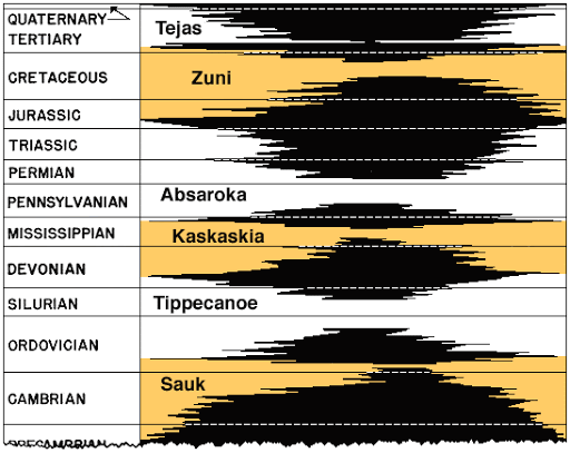
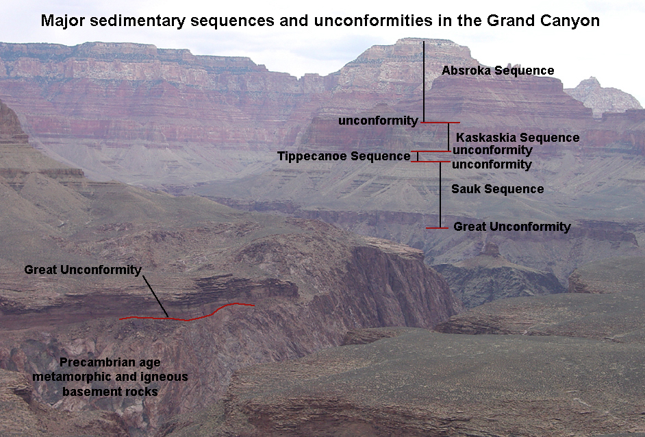
In 1963, a geologist named Lawrence Sloss from Northwestern University would become famous because of a paper published as a part of a symposium held by the Kansas Geological Survey and collectively published in KGS Bulletin 169. Sloss identified six sequences of sedimentation that occurred along the margins and interior of the of ancient North America, known as Laurentia, from the late Neoproterozoic through the early Cenozoic Eras. These sequences were given names. The oldest was the Sauk, followed by the Tippecanoe, Kaskaskia, Absaroka, Zuni, and Tejas. The names of these have their various origins, but geological names are always linked to a physical location. The Sauk Sequence get its names from rocks in the vicinity of Sauk County, Wisconsin. The Tippecanoe Sequence is named for rocks in the vicinity of the Tippecanoe River in the U.S. State of Indiana. The Absaroka Sequence is named for rocks described in vicinity of the Absaroka Range in Wyoming. The name Tippecanoe really refers to the sea that existed in the Iapetan Basin that these layers of strata represent. This sequence of rock layers records the history of this sea at that location. As the Tippecanoe Sea surrounded all of Laurentia, there are many places in North America where you can see a progression of this sequence in the stratigraphic record, including, for example, in the Grand Canyon.
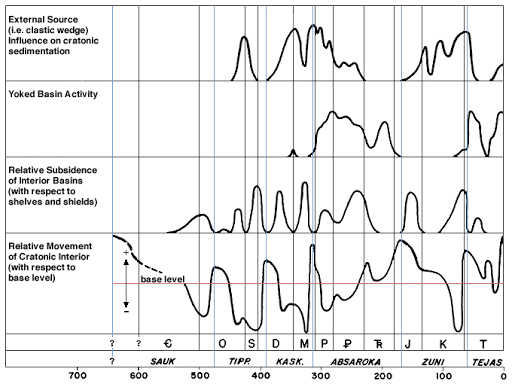
Sloss (1964) identified these sequences through the development of curves based upon data on land subsidence (lowering), cratonic interior uplift, and sedimentation. The lower plot in the figure below, is the basis for the famous sea level curve eventually developed by other researchers working for Exxon in the 1970s. The curve explores global (eustatic) sea level changes as they relate to base level. Each Supersequence, Sauk, Tippecanoe, etc., is similar. The sequence begins with high eustatic sea levels above the base level, progresses through a time of much lower sea levels, and then ends with a major transgression of the sea to end the sequence. Each sequence begins with a sequence boundary, a regression and progradation of the coastline, and then ends with a major transgression. In the middle of all of these sequences are major orogenic (mountain-building) events, as depicted above.
Watch this great video that puts together the Sloss Supersequences with the tectonic and environmental changes taking place in North America. Pay attention to the time periods in the Paleogeographic images. The Sloss Supersequence diagram is much clearer if you watch it in full screen however, you can match the diagram in the video with the diagram above for better clarity.
The Wilson Cycle
Four of these six sequences (Sauk through Absaroka), all were deposited during one very long 1st order megasequence. This megasequence marks the opening and closing of the Iapetus (ancient Atlantic Ocean) as a whole. It is also known as a “Wilson Cycle”. The Wilson Cycle, named after the Canadian geophysicist J. Tuzo Wilson, is a model that explains how an ocean basin opens and closes, beginning with a divergent boundary and ending with collisional subduction between two continents. In his seminal work (1966), Wilson built upon earlier observations of fossil similarities existing on either side of the Atlantic by proposing that there also existed a “proto-Atlantic Ocean” between the continents during the Paleozoic Era. This ocean closed by stages, bringing dissimilar rocks together as the supercontinent Pangaea formed. This simple model can then be applied to other contexts, such as the closing of the Tethys Sea as India moved northward toward Asia, etc. Watch this simple schematic video of the Wilson Cycle below.
Stages of the Wilson Cycle
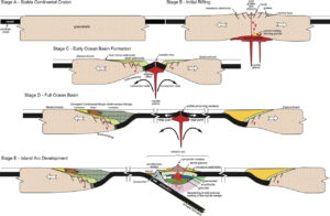
There are nine stages to a Wilson Cycle, as described in the diagrams below. Stage A begins with a stable continental craton and progresses to Stage B, where continental rifting begins. This rifting progresses through stages C through E with passive margins on both sides of the new ocean basin.
Closing of the basin begins with Stage F and then runs through Stage I, where the two continents come together to form a new supercontinent. In the meantime, Stages E through H record the formation of orogenic events and the accretion of terranes. This cycle will be described in more detail in another chapter. The Tippecanoe Sequence takes place in this model between stages E through G.
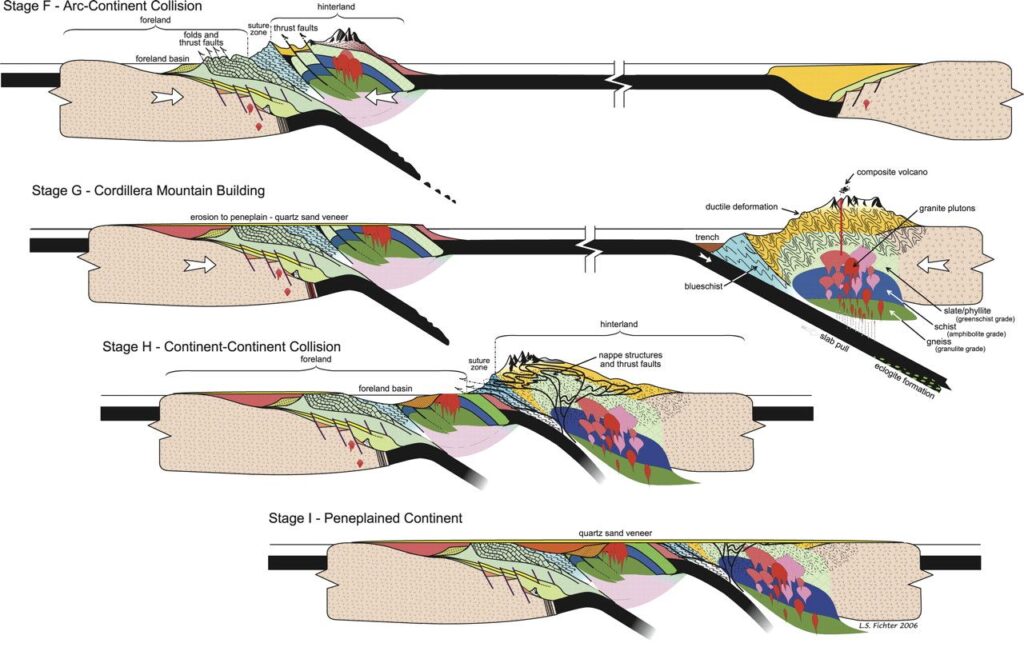 Stages F through I of a Wilson Cycle (Whitmeyer et al., 2007).
The Tippecanoe Sequence begins with missing rock, an disconformity. Called the Knox Unconformity, it serves as the sequence boundary across the craton. It can be seen in the strata of the Grand Canyon as well as it is seen in the strata of western Virginia. It is an erosional surface resulting from a rapid drop in sea level. Throughout the Tippecanoe, sea level is transgressing onto the craton. As average sea level rose, there were fits and starts of smaller sequences, higher order sequences, within the Tippecanoe. These are due to a variety of factors. The story of the Tippecanoe includes Bahamian-like offshore reefs and tidal expanses, extensive muddy submarine landslides, sandy beaches, and a return to carbonates. It includes volcanic ash from Taconian eruptions and a variety of important body fossils.
The Tippecanoe Sequence: Transgressing Seas, Taconian Mountains
The story of the Tippecanoe is the story of the beginning of the end of the Iapetus Ocean. During the late Proterozoic, a supercontinent referred to as Rodinia would break up. The breakup of this supercontinent would create a rift basin into which seawater would flow, eventually widening into a very large ocean. The event left its mark across the Laurentian craton, in the form of a basal sequence boundary. Known as the Great Unconformity, this erosional boundary would mark the start of deposition of sediments along the margin of the Sauk Sea that existed from the late Precambrian through the early Ordovician. The end of the transgression of the Sauk Sea (Highstand Systems Tract) marked a second important sequence boundary (Falling Stage Systems Tract). Known as the Knox Unconformity, it marks the base of the sequence of rocks that record the Tippecanoe Sea’s interactions with North America from the middle Ordovician Period through the middle Devonian. (See stratigraphic column below). Before it was all over, it be interrupted by the Taconian Orogeny, a major orogenic event. Laurentia at this time sat mostly south of the paleoequator with the modern eastern United States along its southern flank. Eventually, the Tippecanoe Sea reaches its penultimate highstand in the middle Devonian and, as the Falling Stage Systems Tract commences the formation of the Wallbridge Unconformity, deposition of Tippecanoe sediments comes to an end.
Eventually, the Taconian Mountains formed off of the coast an arc of Japan-like volcanic islands. Evidence for this is contained within the lithostratigraphic record as widespread and in many cases very thick volcanic ash deposits. While the entire sequence is transgressive across the craton, tectonic change and sedimentation changes taking place due to the process of orogeny along the southern portion of the craton would lead to more localized changes. Relative sea level, sedimentation, and tectonics would lead to lower orders of sea level sequences (3rd and higher). Embedded within the Tippecanoe as a whole then are successively smaller sequences of shorter duration that record events taking place throughout this time period.
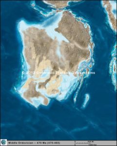
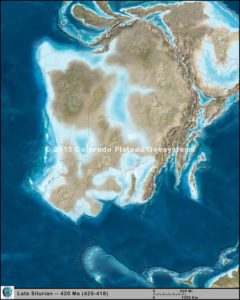
Middle Ordovician Tippecanoe Sea. Note the position of the Paleoequator. The Taconian Island arc is still off of the southern coast of Laurentia (modern eastern North America) and the Tippecanoe Sea lies to its north (forearc basin). Sediments deposited in the forearc basin include the early Tippecanoe Carbonates into the Martinsburg Formation.
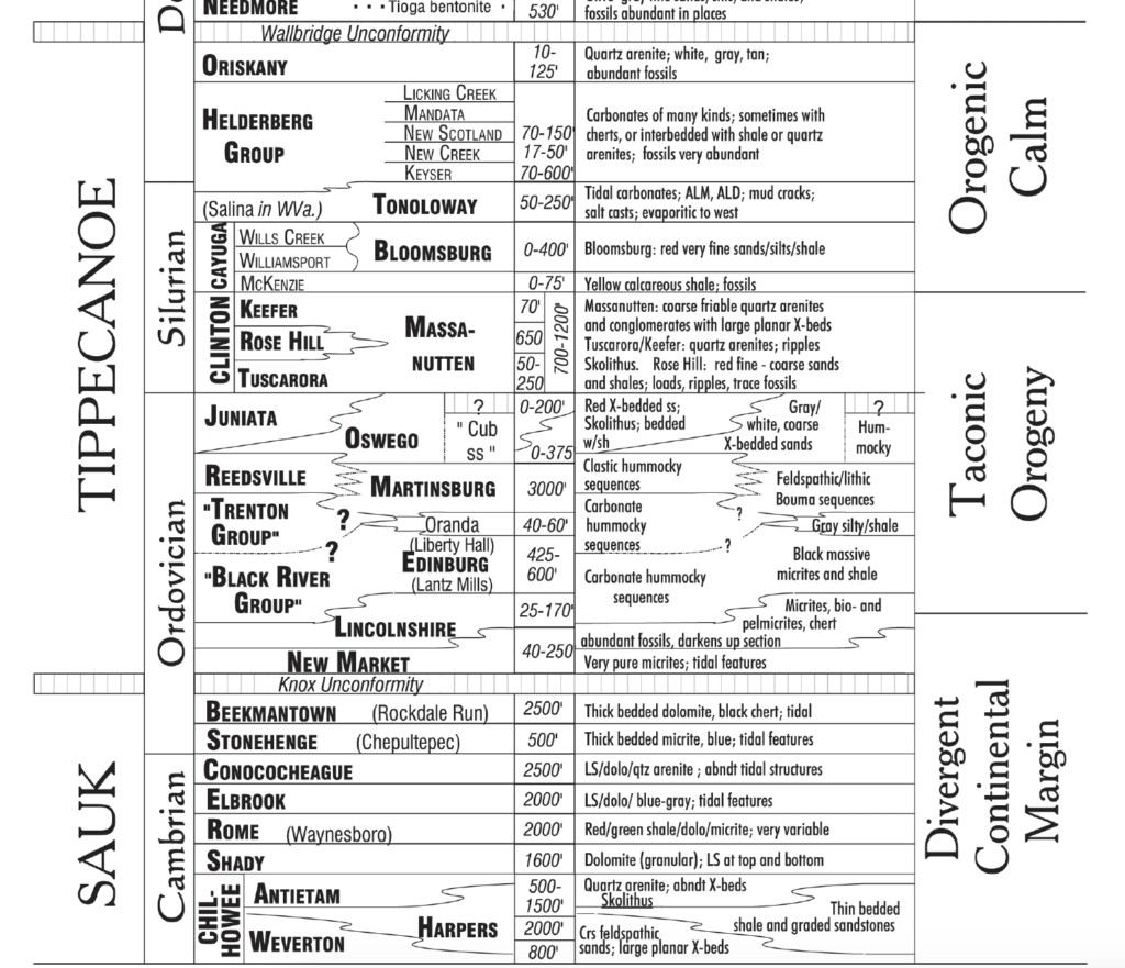
encompassing the lithologic units visited on Day 2 of the field trip. After Fichter and Diecchio (1993).
Tippecanoe Sequence 1
We can divide the Tippecanoe into two smaller sequences. The first records deposition directly following the Knox Unconformity and ended with the onset of coarse sandstones. This 3rd order sequence includes the carbonate bank sediments of the lower Tippecanoe, the New Market Limestone through the early Martinsburg Formation. It also includes the very distal upper Martinsburg Formation to the base of the Oswego Formation, where an unconformity existed across some of the area. The Oswego Formation has places in it that are rich in river cobbles, a good indication that this represents sediment that was being deposited very near land. Below is an accommodation space plot for this 3rd order sequence:
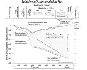
This plot might be a bit confusing at first. But, you are looking at the cross section of the Taconian forearc basin over time during this portion of the Ordovician Period (left to right). As time passed the shelf basin was deepened and accommodation space increased (hachured area). Carbonate deposition was still the norm, as it was during the latest portion (uppermost) of the Sauk Sequence.
The contact between the lower Ordovician New Market Formation and Lincolnshire Formation. These carbonate deposits are typical of rocks deposited at a part of the “Great American Carbonate Bank”. They also represent shallower-water conditions. This is because of their carbonate lithology, fossil content, and structure.
The sequence began with the lowstand systems tract (LST), as recorded by the New Market Limestone. The sequence boundary already existed (Knox Unconformity) and the bulk of sediment being deposited was being formed in place by organisms secreting carbonate for their shells, tests, and some perhaps through evaporation. The seas at this time were conducive to calcite, rather than aragonite, being the primary shell-forming mineral. Abundant seafloor spreading is keeping magnesium levels stable and a warm global climate favored widespread biochemical carbonate production.
This sequence began to deepen as the onset of the Transgressive Systems Tract (TST) approached, marking the progression of deposition into the Edinburg Formation. This deepening, or subsidence, was the result of the downward flexure of the forearc basin. The transgression of relative sea level was due to the approaching Taconian island arc. Subsidence continued until about 468 million years ago, when deposition of the lower Martinsburg Formation began. Terrestrial sediments took over, eventually drowning out carbonate production.
Martinsburg formation, Page County, VA. The Martinsburg is composed of cyclical packages of turbidite sequences. These “fining-upward” sequences are interpreted as representing offshore mixed carbonate-siliciclastic conditions below wave-base. The dominant lithologies are siltstones and shales. Carbonate-rich materials are richest at the base of the formation, where the transition from the Edinburg Formation below is gradational in many places (Stickley Run Member, Martinsburg Fm.).
Graptolite fossils in the Martinsburg Formation, Page County, VA. Graptolites are fossilized here as carbon films. They break into small pieces very easily. Preservation in such detail is indicative of rapid burial, which would be typical in turbidite deposits.
During the Highstand Systems Tract (HST), submarine turbidite (submarine landslide) deposits became the norm. Accommodation space began to diminish as the Taconian highlands approached. During HST, sediment supply from land typically causes a prograding shoreline situation. This was likely the case for the Martinsburg Formation as its deposition progressed. Beginning as a very distal carbonate/mud in the lower Martinsburg, it eventually prograded into more proximal thick-bedded deposits as terrestrial sediment supply continued to increase and relative sea level dropped. By the end of Martinsburg Formation deposition, over 900m of sediment had been deposited and an erosional boundary formed at the base of the Oswego Formation.
At this point, the Falling Stage Systems Tract (FST) was completed and an entire sequence stratigraphic cycle is complete.
During this time, the craton as a whole experienced the results of an overall rise in global (eustatic) sea level. But, the paleocoastline (of today’s mid-Atlantic) saw a period of transgression (New Market Lm to Edinburg Lm) followed by a period of regression (Lower to Upper Martinsburg Fm). The end of this first 3rd order sequence of the Tippecanoe brought to an end the Ordovician Period and the full Taconian Orogeny was underway.
Tippecanoe Sequence 2
The latter half of the Tippecanoe is marked by another 3rd order sequence.
Beginning with the landward Massanutten Formation, replete with its Skolithos sp. and Arthrophycus sp. burrows marking it as sandy shoreline facies, this entire sequence ends beneath the Wallbridge Unconformity. The Taconian mountains reached their peak elevation during the late Ordovician and very early Silurian and were eroding into the nearby passive margin basin.
Massanutten Sandstone, Woodstock Tower, Massanutten Mountain, VA. The image below is of a bedding plane surface on a nearly vertical slab of Massanutten Sandstone. Replete with what are very likely Arthrophycus sp. trace fossils, the Massanutten Fm. represents shallow water conditions typical of the base of a sequence.
Hand sample of the Massanutten Sandstone. Note the coarse-grained nature of the specimen. Unlike the base of the other 3rd order sequence of the Tippecanoe, the Massanutten Sandstone is not a carbonate.
This passive margin (FST to HST) brings with it an eventual break from siliclastic sedimentation, marking the erosion of the Taconian mountains now to a peneplain. With the eventual onset of the Acadian Orogeny coming at the end of the Tippecanoe, there is time for a carbonate bank to form once again in this still very tropical sea, south of the Paleoequator. The transition from the coarse sandy Massanutten Sandstone to the fine-grained intertidal Bloomsburg and Tonoloway Formations and into the Helderberg Limestones that represent this new carbonate bank is very typical of TST conditions. Sea level is rising, even if the rocks represented here are, overall, more proximal to shore. Deepening is occurring.
Bloomsburg Formation, Fort Valley, VA. This iron-rich sandstone was mined as a source of iron during the 19th century in the Shenandoah Valley of Virginia. Finer-grained than the Massanutten Sandstone, it represents the early onset of TST.
Tonoloway Formation, hand samples from Corridor H in West Virginia. The left image shows evaporite structures in the form of salt casts. There is a short-term cyclicity evident in the sample also, as the environment alternated from carbonate production to sabkha. The image on the right is of dessication cracks, a cross-cutting feature indicative of very dry conditions.The
Tonoloway Formation, Corridor H, West Virginia. This outcrop of the Tonoloway formation well represents the higher-order cycles that exist just within this single formation. Carbonate production occurring in marine conditions is alternated with periods of intense evaporation.
Helderberg Limestone escarpment, New York. These massive limestones represent the deepest waters of the HST.
The sequence boundary is best placed at the top of the Oswego Formation. LST existed at the time of the deposition of the Massanutten (Tuscarora) Sandstone. The coarse sands and trace fossils of the Massanutten are indicative of shallow water. The Transgressive Systems Tract, TST, began when the first carbonates appear in the stratigraphy, interbedded with the very iron-rich red beds of the Bloomsburg Formation. The seas were beginning to rise and accommodation space was increasing. The transgression continued with the tidal Tonoloway Formation. This very interesting formation, at once full of ostracode fossils, salt casts, and mud cracks, is interpreted as representing a sabkha-like environment. It was a time of relative aridity with intense evaporation. While the salt casts of the Tonoloway Formation were being generated in what is now the Virginias, major salt deposits currently residing under Lake Erie were also forming.
As this new carbonate bank developed, it was deepened as sediment supply from the land diminished and accommodation space increased. This led to the formation of the very fossiliferous Helderberg Group limestones of the late Silurian and early Devonian. Having arrived now at HST, the waters of basin were as deep as they were going to get. As the sequence matured, a new moutain-building event began its onset, the Acadian Orogeny. The first clean quartz arenites show up in later Helderberg deposits, marking the coming of another terrestrial highland, called “Avalon”. These arenites mark the beginning of the prograding deposition so indicative of HST periods. The Acadian Orogeny got its start with the deposition of the Oriskany Sandstone, a fossiliferous and Skolithos sp.-rich sandy shore facies.
This sequence again ends with the formation of a sequence boundary as FST once again begins due to the sedimentation and then tectonic changes that lead to the formation of the new sequence boundary, the Wallbridge Unconformity. After a time, these Acadian mountains eroded to a plain. Following some amount of time and the Wallbridge sequence boundary, the Kaskaskia supersequence progressed.
4th Order and Higher Cycles
Within these two 3rd order sequence that have been described above, there are certainly 4th and perhaps 5th order parasequence sets and parasquences to be found. Identifying such short-term packages of sediments would add much to the story of the Tippecanoe. Any in-depth analysis of that level of detail goes beyond the scope of this case study, however.
Final Thoughts
As illustrated in the 2nd order Tippecanoe Sequence and the two 3rd order cycles contained within it, sequence stratigraphy can provide a model for how to interpret the changes we see in facies. These changes, resulting from the complex interplay between tectonics, eustacy, sedimentation, and relative sea level make up the story of the strata. The application of these models to the this stratigraphic story brings a richness to the history of a basin that is less apparent than it would be otherwise. The tools of sequence stratigraphy, on other words, are necessary for hearing what the rocks are telling us about their story!
References
Fichter, L.S. and Diecchio, R.J., 1993, Evidence for the progressive closure of the Proto-
Atlantic Ocean in the Valley and Ridge Province of northern Virginia and eastern West
Virginia: in National Association of Geology Teachers, Southeast Section Meeting Field Trip
Guidebook, p. 27-49.
Haynes, John T., Pitts, Alan D., Doctor, Daniel H., Diecchio, Richard J., and B. Mitchel Blake Jr. (2018). Appalachian Basin Stratigraphy, Tectonics, and Eustasy from the Blue Ridge to the Allegheny Front, Virginia and West Virginia: In West Virginia Geological and Economic Survey Field Trip Guide FTG-10. 86p.
Sloss, Lawrence L. (1964). Tectonic Cycles of the North American Craton. Symposium on Cyclic Sedimentation: Kansas Geological Survey, Bulletin 169. pp. 449-459.
Whitmeyer, S.J., Bailey, C.M., and Spears, D.B., 2015, A billion years of deformation in the
central Appalachians: Orogenic processes and products, in Brezinski, D.K., Halka, J.P., and
Ortt, R.A., Jr., eds., Tripping from the Fall Line: Field Excursions for the GSA Annual
Meeting, Baltimore, 2015: Geological Society of America Field Guide 40, p. 11–33,
doi:10.1130/2015.0040(02).
Wilson, J. Tuzo (1966). Did the Atlantic Close and Then Reopen?